
Having gone to bed at a little over 6,000 feet above sea level and surrounded by snow, I was a little worried that I'd be freezing cold and that the tent would be covered in frost when I woke up in the morning. To my delight, neither came to pass, and as I climbed around on the rocks behind camp - looking for rock art - just before sunrise, I found myself hopeful for the day ahead.

After watching the sun crest the horizon, I hopped from stone to stone on my way back to camp. Cereal - with extremely cold milk, my favorite - and a few minutes putting away the tent, and I was ready to start my search for the petroglyphs I knew were out there. Somewhere.
In my research, I'd found several references - and photographs - of the petroglyphs along this, the Pahranagat Trail. Unfortunately, none of them gave specific locations, instead using phrases like "facing east" or "in Black Canyon."
Given that I was in Basin and Range country - where countless ranges run north-to-south, their walls separated by vast basins - not to mention BLM land, where roads are (more) plentiful than other public lands, I had my work cut out for me.
With my binoculars in hand, I hugged the hillsides as much as possible, and stopped frequently whenever desert varnish-covered boulders presented themselves.


For several hours, I climbed spur road boulder fields on the edge of the wilderness. Sometimes I'd climb the same field several times, trying my best to cover the ground in a grid pattern so as not to miss any etchings in the stone. Several times, I tried to "line up" the orientation of the carsonite post, hoping that whoever had placed it was thoughtful enough to use it as a sort of "rock art gun sight."
Alas, I at each location, I was unsuccessful. It was quite literally like searching for a few needles in a 40 square mile haystack.
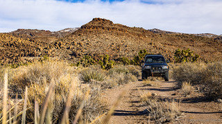

Travelling every road I encountered - especially the ones that weren't on my maps - I found myself hugging the wilderness boundary, snow covering the ground at higher elevations. It was - despite my growing frustration - beautiful.

While most roads were primarily at low enough elevations that snow was intermittent - at least on the road itself - things started to change as I worked my way up the eastern side of the wilderness. Climbing through 5,000, then 5,500 feet - and even as the road traversed sun-drenched southern-facing slopes - the route was completely snow covered.

At 6,000 feet, I was plowing through untouched snow more than a foot deep. Taking a look at my topo maps, I was within a couple hundred feet of the highest point of the route, but with the remainder dropping down the north side of the mountain, I made the call to backtrack the way I'd come. It wasn't like I was going to be searching for petroglyphs when I was just focused on keeping the truck on the road!
By now, I'd searched for much of the day and had - at least as far as rock art was concerned - nothing to show for it.

Ultimately, I was forced to come to terms with something that others who know me probably consider obvious: For me, as much as I love exploring the outdoors, my favorite part of the adventure is the actual finding, seeing, and accomplishing of those things I set out to find, see, and do. Be they grand vistas from a hard-to-reach summit, rock art etched into varnished sandstone, or the ruins of a failed gold mine, it's the act of actually achieving them that I enjoy.
ō′vər-lănd-er
one who engages in self-reliant travel to remote destinations where the journey is the principal goal.
So yeah, I'm not a real overlander. And that's just fine by me.
This realization - that it's not the journey/search that brings me joy - was a nice feeling. And, along with the knowledge that future roads in the Pahroc and Big Rocks Wilderness would only take me to higher elevations than I'd already explored, I decided it was time for a change of plans.
Luckily, I'd mapped more than twice as much stuff as I had time to see, so rather than spend the last two days of the trip searching for unknown needles in this vast haystack, I pointed the Tacoma east, towards ruins and rock art that I knew where to find. Mostly.
The Widowmaker
My first destination turned out to be just across the valley. Having mapped - but never visited - a loop route to-and-from the ghost town of Delamar for a trip we'd taken a couple years earlier, I soon found myself bumping along a worn-out road, crisscrossed with washes.


In 1889, prospectors John Ferguson and Joseph Sharp discovered gold around Monkeywrench Wash. A mining camp was established and in April 1894, Captain Joseph Raphael De Lamar bought most of the important mines in the area for $150,000, renaming it Delamar. At the same time, a newspaper called the Delamar Lode began publication and the Delamar post office was opened.
From 1895 to 1900, Delamar was the primary ore producer in Nevada. Buildings here were made of native rock and by 1896, the Delamar mill was handling up to 260 tons of ore daily. Such production required manpower, and by 1897, more than 3,000 residents called this place home - a hospital, opera house, churches, a school, several businesses, and saloons supporting those who worked in the mines.


The town was almost entirely destroyed by fire in the spring of 1900 and, in 1902, De Lamar sold his mines which had produced $8.5 million in gold to new owners. After installing a new 400-ton mill in 1903, they continued production until 1909, outproducing all other mines in the state and bringing in another $4 million in ore.

Unfortunately, the gold in the Delamar mines was embedded in quartzite, which created a fine silica dust when crushed. Because water was scarce - piped in from more than 12 miles away - the crusher in the mill was run almost dry and the deadly dust was inhaled by the miners, causing silicosis and an ultimately death. So many men died working these mines that the town itself became known as "The Widowmaker."


Here's an article on Delamar from the June 1970 issue of Desert Magazine: Hidden Gold of the Piautes | Desert Magazine
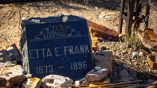
On my way out of town - along a much more nicely graded route than the one I'd come in on - I passed the Helene Cemetery. A ghost town even at the time of Delamar, I stopped in for a quick visit and to pay my respects.

I Don't Have Access to that Information
From Delamar, my plan was to continue east - this time in search of rock art in Rainbow Canyon. Another place I'd marked on the map the last time we'd visited the Pahranagat Valley, we'd simply prioritized it lower than some of the more dramatic rock art of Mt. Irish, the White River Narrows, and the Shooting Gallery.
It was, as I passed through Caliente, that I noticed the BLM Field Office along the side of the road. Thinking that there might be a way to get my original plan back on track, I stopped in to see if the information officer could share any more specific information about rock art in the South Pahroc and Big Rocks Wilderness'.
Initially, she seemed hopeful. Coming out from behind her desk, she quickly walked over to the Lincoln County Rock Art guide that I'm sure everyone who's visited the area has already seen.
In the nicest way possible, I let her know that I'd already visited all of the sites covered in that guide, and that I was looking for information on the lesser-known sites, specifically, those that were on the border or within the two wilderness areas.
Again, she seemed hopeful, heading to the back office to pull out the Wilderness Management Plan and Environmental Assessment for the Big Rocks, Mt. Irish, and South Pahroc wilderness areas. Unfortunately, I'd already read that report as well, and though it contains photos of some of the sites, and mentioned the existence of others, it didn't give any clues to their actual locations.
After pressing a bit, she somewhat reluctantly let me know that "This is all I can give out. Only the geologists have access to the actual locations of the lesser-known rock art."
Though a little disappointing - I'd hoped that by showing up in person, I might get a bit more information than is available on the internet - it's completely understandable given the sensitive nature of these sites, so I thanked her for helping as much as she could, and then continued on my way.
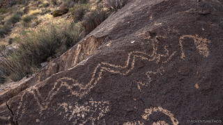
Rainbow Canyon
Ancient people inhabited Rainbow Canyon starting about 10,000 years ago. Several cultures have come and gone, including nomadic hunter-gathers, ancient farmers, and - in more modern times - railroad men. Several sites exist along the north-south corridor that runs along the Meadow Valley Wash.


On the other side of the tracks, the wash - constrained between volcanic cliffs on the west and a berm that protects the railroad tracks from flooding on the east - funneled me towards a tunnel through the ridge. Dug by railroad workers to direct flash flood away from train traffic, it now served as a secret passage to my first pictograph site.


Knowing I still had several more sites to visit - and with limited daylight - I made my way back to the Tacoma and continued south on NV-317. This highway - between Caliente and Elgen - was a pleasure in itself. Continually crossing over - and through during times of high water - the Meadow Valley Wash, it is crossed by several steel train bridges that carry freight along this route.


A second site - this one containing both pictographs and petroglyphs - came up quickly. Here, a short spur led off the highway to a camp site that's been used for thousands of years, nestled into a side canyon.


I had less than an hour - after visiting the second site - before sunset as I slowly made my way south. Unsure what I should do about dinner and camp, I pushed those small details out of my mind as I pulled up to the location of the next set of petroglyphs.


Headed to the final site - only a couple miles north of Elgin - I decided that I ought to first check out Elgin itself, before hitting the rock art on my way back towards Caliente.
Elgin was a siding on the San Pedro, Los Angeles and Salt Lake Railroad (now part of the Union Pacific). Homesteaded as early as 1880, it became an important watering stop and even had its own post office from 1913 until 1966. A school - built in 1922 and operated until 1967 - educated first through eighth grades in the single room.Information Sign


After visiting Elgin, I made a quick stop at the final petroglyph site.

My day hadn't gone at all as I'd planned, but as is often the case, everything worked out. After making a quick dinner at the train tunnel I'd visited earlier - still hoping that a train would materialize on the other side - I continued north through Caliente where I fueled up and made a plan for the remaining two days of my trip.
I had no idea at the time, but I'd end up wandering through colorful cathedrals, searching for some of the most unique petroglyphs I've ever seen, hiking to a pictograph taller than me, and spelunking through caves in search of vibrant hues of red and yellow.
Looking back now, my change of plans was totally the right call!
The Whole Story


November 2023 Update: This is not the end of the story (or the beginning)! To read the entire saga, check out these fun updates:
The 2023 Pahranagat Trail Series

")

Enjoying this trip and waiting for more. Were the RR folks working on the track, or is the track no longer used?
Thanks Bill! Bit of time between the last installment and this one because I was out exploring the Joshua Tree area for a while, but hopefully I'll be able to get the rest of the story posted over the next week or so!
The RR folks were working on the line, though at the time I took the photo, that crane was on a siding. The line there through Rainbow Canyon is still in use by UP.
Love this site. Thanks Bill. You inspire me to get off my old ass and get out there. I’m retired and have plenty of time, just looking for someone to go along. Anyway already looking forward to your next adventure.
Glad you're enjoying it Ken! There are tons of trips to get you motivated, and I'm always trying to get out there as much as I can to add more stories to the list. I don't know how long I'll be able to (or want to) keep it up, but for now, I'm very much enjoying it!
If you run across stories that you particularly like, or that remind you of some experience you've had in life, I always love to hear about it, so by all means, leave a comment! ?
Cheers, Dan
Oooh, this area is now on my list of places to explore! I keep going back to Gold Butte or Valley of Fire, but I need a change...maybe not in January though.
Thanks Kim! This is definitely a place rich with history. If you enjoyed this part of the story, you'll definitely enjoy the next couple installments, and you should also check out a trip we took a couple years ago that was in the same area: It's a Bird, It's a Plane, It's Pahranagat Man | Mid-Winter #1
Thanks! I have so many more destination goals now, thanks to you!
wow love all the pictures you always inspire me to go exploring.
I don't think they call them (An old caboose sits next to the restored schoolhouse.) a caboose anymore. What I heard is that they call them a Fancy Rear End Device - FRED. Maybe, I'm wrong.
Love the photography, thank you.
Really?! Crazy, how the times change. Actually, I don't think I've seen one on a train in years. I wonder if they are still in use, at all...
Okay, so it's called a Flashing Rear End Device, still FRED. It's on Wikipedia, so it has to be true: https://en.wikipedia.org/wiki/End-of-train_device.
Yea, times do change, don't they.