
It was with the best of intentions that I planned a trip to explore the Pahranagat Trail in southeast Nevada. The very first trip where I'd be flying - rather than driving - to make the trek south, I'd work my way north from Las Vegas to explore three wilderness' that were once home to Native American Indians: Arrow Canyon Wilderness, South Pahroc Wilderness, and Big Rocks Wilderness.
It was a classic example of counting chickens before they hatch, but we'll get to that part of the story in good time. At the beginning, things were going quite well.

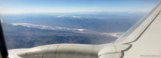
This being my first time flying in to pick up the Tacoma, I spent a few minutes unpacking - and stowing - my clothes and the few things I'd brought along, and then headed to the grocery story to provision the fridge and In-N-Out to provision my stomach. An hour later, I was headed northeast out of Las Vegas.
Having landed just before 1:00pm, and with a couple hours worth of driving to Pahranagat Wash and the Moapa Valley, I knew that I wasn't going to get any exploring in on the first day, but I wasn't complaining - it was a whole lot better than a 22-hour drive!


It was just before 5:00pm - and just moments after sunset - when I reached my camp site. At the edge of the Arrow Canyon Wilderness, the striped walls of the wash rising up around me as I set up the tent and settled into my book. As usual, I didn't last long before dreaming of what was to come.

The Following Morning...
Knowing I had a long day ahead, I set my alarm for a few minutes before sunrise. The first order of the day was a five-mile hike through the narrows of Arrow Canyon, so after eating a bit of breakfast and putting away the tent, I left the truck right where I'd parked it the evening before and covered the final few hundred yards to the trailhead on foot.

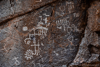
Never one to be burdened by the need to do first things, first, I was delighted to stumble on some petroglyphs before I even made it to the narrows. I'd known that there was rock art in the area, but I'd only hoped that my constant poking around would allow me to discover some of it while I was here.


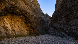
My spirits raised by the early discovery, it was time to get back to first things... second, and start my hike through Arrow Canyon. The inclined strata - mostly limestone - that encloses the lower end of Pahranagat Wash is deep and narrow for nearly a mile. Towering cliffs - up to 300 feet tall - transported me back through time, the narrow passageway a constant reminder of the tremendous flash floods that carved the channel.


My eyes constantly drawn upward, I had to continually remind myself to turn my gaze down - towards the base of the wall - in search of evidence of those who'd come before me.


For a mile or so I hiked through the narrows. Beneath my feet, softball-sized rocks lined the wash, and with no real established path - I'm sure everyone simply wanders between the walls - I found myself wondering if the entire hike was going to be so laborious.
Little did I know just how much I'd be wishing for this uneven surface, shortly.


Halfway through the canyon, and just after passing a similarly narrow - but much shorter - side canyon (named, cunningly, Side Canyon) that entered from the south, the terrain changed dramatically. Gone were the rocks, replaced by the slickest, slimiest mud one can imagine and sections of wash still covered by 12 inches of standing water. Where the first half of the hike had taken only 40 minutes, the second half would require more than two hours and significant cussing.
There were no photos.
Ultimately, this gauntlet of gunk led to a dam built by the Civilian Conservation Corps (CCC) in the 1930s, passage further made impossible by the moat of muck between me and the dam.

Glad to have reached the end, I radioed my starship to transport me back to the rocky narrows, but the deep canyon walls must have blocked my signal. As such, I retraced the wet, muddy trail as carefully as I could, my arms, legs, and torso bombarded by the Catclaw Acacia (Senegalia greggii) as I bushwacked my way through.
Eventually, I reached the entrance of Side Canyon and thanked my lucky stars for a surface that - while I'd considered it uncomfortable the first time through - was, at least, not trying to kill me with every step. The reason for this - I realized later - was that nearly all the water that flows down Arrow Canyon from seasonal rains is via this Side Canyon drainage; the CCC dam has effectively stopped flow down the Pahranagat Wash above this point.
Once again, it was time to enjoy the narrows.


Even though the hike through Arrow Canyon had taken much longer than I'd expected - thanks to the muddy conditions - I decided that I still might as well head around to the top of the CCC Dam in order to check it out from the other side. I knew this too could add quite a bit of time - unlike the lower route, my research suggested that the road above the dam ended "when the ground got too muddy to continue" - but I decided that I'd eat lunch upon my arrival, and then just enjoy myself rather than worrying that I was losing daylight.
Slowing down isn't always easy.


My belly full, it was 1:00pm - about four hours of daylight left - when I set off on foot for the upper side of the dam. With the ground soggy enough that I'd had to stop a mile before the end of the road, it wasn't a long hike, but I knew that round-trip was going to take an hour or so by the time I stopped for photos, admired the views, and did my best to clean all the slop off my shoes.


An old, fixed rope hung from the dam, and probably would have held my weight well enough to climb 30-40 feet down the front side, but even if there hadn't been several feet of mud and water down there, I certainly wasn't dumb enough to risk it. Never mind injuries, a broken rope would mean walking through the mess I'd just endured a third time!
On the way to and from the dam, I ran into some more shield-like rock art along the wash.


I'm sure I didn't see all the petroglyphs in this section of the Pahranagat Wash, but I did discover an alcove with one of the most mortero-covered stones I've ever encountered.

After leaving the Arrow Canyon Wilderness, I followed Pahranagat Wash to the north - pavement making quick work of the miles. I can't count the number of times I've passed Coyote Spring Valley on US-93, wondering what all the palm trees are about, and hoped that this time - coming from the east - I'd get a better sense. Unfortunately, all roads leading into the area were closed, leaving me as curious as ever as to what this place was.
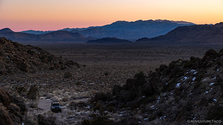
Eventually, I turned off the highway, following a side road into Eightmile Valley on my way to the South Pahroc Range Wilderness. This is where I planned to spend the next 24 hours - or so - poking around the plethora of roads and glassing the hillsides for rock art.


Eventually - and having climbed to elevations with significantly more snow - I called off the search. I'd failed to find the petroglyphs somewhere in Eightmile Valley, but with three more full days of poking around, surely there was enough time - for even the blindest of us - to stumble upon something of interest.
For now, it was time to find camp.

Climbing into bed, a little voice in the back of my head nagged at me as I drifted off to sleep: if I couldn't find petroglyphs - that I knew existed - in the 2-or-so square miles of Eightmile I'd traversed, how the heck would I find any in the South Pahroc Wilderness, that I planned to explore the following day.
It was a good question.
The Whole Story


November 2023 Update: This is not the end of the story (or the beginning)! To read the entire saga, check out these fun updates:
The 2023 Pahranagat Trail Series

")

Always wondered what the name of Moapa Peak could be, Coyote Springs (And palm trees) was a master planned community that went bust. All that's there is the golf course today. Almost directly across Rt.93 (From the golf course) is a trail that goes up and over those mountains facing you into the National Wildlife Refuge System. There's a trail that goes 80 miles up to Alamo Nevada that starts at the Visitor Center. It's a nice area. Several off trail's and hiking only canyons and trails. Hidden Cabin is a great hike almost 8000ft. up into a mountain peak. It's well stocked and in fine shape. I live moments from this place. It's where I spent my 'Anti-Super Bowl Sunday'. Happy Trails...
Makes you wonder when did they actually sit there to draw petroglyphs! What were they thinking, what were they like, what was that area like for them then?