As it seems many of our nights in Colorado were, this one was a cold one. Camped at 10,400', that was probably to be expected, but I didn't expect my packaged of baby wipes to be frozen in the morning, and my morning clean-up wasn't a pleasant experience given that they were. 
But the elevation did make for a nice sky at sunrise - for that, I was grateful.

And, with another day - or morning as it'd turn out - of clear blue skies above, it didn't take long for the sun to warm camp up enough that we all ventured out of our tents to greet the new day.


In fact, this was the day we'd all been waiting for - it was the first day (of many, we hoped) that we'd really experience the grandeur of Colorado's mountains. And, it was the first day that we'd get some technical wheeling under our tires.
Eager to get underway, we made quick work of breakfast and breakdown of camp, and soon we were on the road - our camp site only a few hundred yards from the first short trail we were tackling on the day: Chihuahua Gulch.

Chihuahua Gulch is a short and enjoyable trail that climbs into and then through a valley below two of Colorado's 14,000-ft peaks - Grays and Torreys Peak. As we broke through the dense treeline into the valley, I remarked over the CB that I probably hadn't needed to stop a few hundred feet downhill to take a bunch of photos!


At just over two miles each way, though the trail is a relatively short one, the scenery does not disappoint - packing a lot into that short distance. And the trail itself is fun too - the terrain varied, offering flexy sections, rocks, and even several easy water crossings.
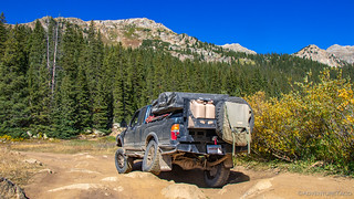


We reached the end relatively quickly and after a few minutes saying hi to hikers who were on their way to bag a "14er" or two, we got our rigs turned around and headed back the way we'd come, our next destination just a few miles up the main road.
We arrived at the Pennsylvania Mine to a lot full of cars, but were pleasantly surprised to find that we were - for the moment - the only people exploring the mine; everyone else off on a hike or other adventure, leaving us in peace.

This mine was a rich producer of gold and silver in Colorado, it's best year occurring in 1893 - the year of the great silver crash. It continued to operate through the crash, producing $3,000,000 in earnings between 1893 and 1898. A major source of pollution for the water in nearby Peru Creek, several cleanup efforts have occurred over the years and are now complete. (from Funtreks Guide to Colorado Backroads & 4-Wheel-Drive Trails)


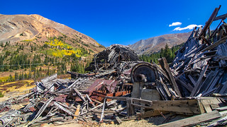
Not only was the mill still in remarkably good condition for its close proximity to a major road and lots of human traffic, but there were tons of cool old artifacts to check out as well. The boilers made of 1" thick steel - a little cattywampus, the smelter - ready to melt silver for bars, and two old pistons that powered a huge drive belt - relics from Ingersol Rand.
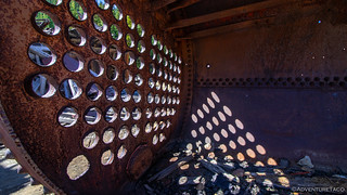


It took us a while to get our fill of these ruins, but eventually we pulled ourselves back to the trucks that were biding their time in the parking area, like cats ready to pounce.

Done with our exploration of the immediate area, we headed back down toward Montezuma, pausing momentarily at a bridge the crossed Peru Creek, the covered in some brilliant white substance - pollution from the mine.

As we entered Montezuma, one thing in particular stood out to me. Unlike nearly every other population center that we drive through - where dirt ends and pavement begins - Montezuma was exactly the opposite. As we drove into town on Montezuma Rd, the pavement ended and dirt began - both main streets in town gravel, the entire town evoking a feeling of going back in time.
Caught completely off guard, I forgot to snap a photo. We continued on.
Looking back on it now, our destination now was what I can only really refer to as our first real Colorado trail. Not that it was difficult in any way - that would come shortly - but it took us to a height of 12,103' with views of the taller mountains around us! Our destination was Webster Pass.
It all started out innocently enough - making our way up and unassuming valley - our elevation gain steady, but seemingly slow. In front of us, what appeared only as a range of scree hillsides. These were mountains, really.

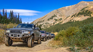

Up and up we climbed, the elevation gain now more dramatic, switchbacks necessary in order to make progress. Still, it didn't seem that we were achieving anything unusual. I mean, the views always get better as you go up, right?


But as we reached the pass, it was something special. Getting out of the trucks, you could tell we were high by the cool temps and strong winds. A sign announcing our elevation - 12,103' - surprising when we glanced around and realized that yes, nearly every peak we could see was still hundreds of thousands of feet above our current position.
There, in the near distance to our east was the aptly named Red Cone - a one-way trail that we were set to tackle next.


But first, we had to make it down the back side of Webster Pass. Unlike Red Code - despite the fact that it was in some places only a few inches wider than our trucks, that there were signs warning against full-size truck travel, and that there were several washouts along the way - this road was bi-directional. We proceeded with an abundance of caution.


Having made our way through the narrowest - and frankly, dangerous sections - we eventually encountered a group of six UTVs making their way up the back of the pass. Squeezing ourselves as far as we could onto the edge of the road, they did the only thing UTVs know how to do - they climbed off-trail on the uphill side to go around us. Classy.

From there, it wasn't long before we reached the bottom - or at least, as near the bottom as we were going to get - and decided that this would be a great time to have lunch. Parked near a small stream, and with Red Cone looming over our shoulders, we pulled out our chairs, assembled our sandwiches, and recounted the narrowest spots in our descent - happy for our narrow wheel base, and wondering whether it would have presented an issue for Frankenstein's long travel.
Little did we - or at least I (since I have a suspicion that this wasn't the case for Brett) - know at time, that we were in for quite a bit more before the day was over!
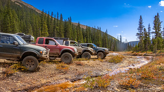

Our bellies refilled and with all the time in the world to stop and chat on the trail, we climbed back into our trucks and headed to our next trailhead - the road to Red Cone. This was the most difficult trail (by rating) that we'd done so far, largely due to a couple of the obstacles on the way up the mountain. It wouldn't be the most difficult of the day - though now I'm getting a little ahead of myself. 
As we made our way up the initial ascent - which started at just over 10,000 ft - we quickly came to the most difficult of the obstacles - a rocky section that required precise tire control in order to maintain traction on the otherwise dug-out, dusty trail.
Monte was up first.


Despite what looked like a good line, he was almost immediately high-centered on his driver side slider, his front and back wheels grasping for traction in dug-out holes from previous wheelers. He tried again. Crunch. And again. Bang. Even with spotting, he was closer and closer to danger - his rear tire and bumper flirting with the exposed rock.

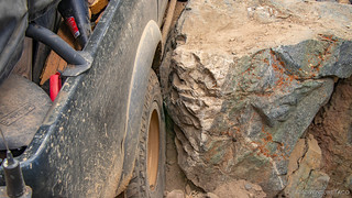
Eventually, we resulted to stacking rocks to give him a bit more traction, and with that he was up and over. Quite the feat when he was working - essentially - with two wheel drive.

Next up, it was Brett's turn. With larger tires, more familiarity with the trail, and lockers - though I don't know if he used them both - he made the entire situation look easy, and still - his sliders didn't go unscathed.


Mike and the Redhead followed Brett, and with judicious use of the throttle - and also equipped with lockers - Mike too stepped up through the rocks, his skids and sliders clanking here and there, his tires getting thrown around as he was pushed left and right.


And then it was my turn. Clearly my truck would make it - but that didn't mean I wasn't a bit nervous. After all, I'm the first to admit - and tell others - that our trucks, even in stock form, are more capable than 90% of their drivers. With both lockers engaged, I approached the rocks. I steered as directed. The front tires climbed up and came down - the sliders bashing away.
And then I stalled.  Laughter broke out, naturally.
But that's just part of the game, and I fired the truck right back up and climbed my way out - just like everyone else. It was a fun time - though, as I'd recount later - right on what I felt like the edge of my skill level was.

From that point on though, Red Cone was what I'd consider easy. That could have simply been a relative rating, but with my adrenaline pumping it didn't seem like we really hit anything else that caused any concern.
As we wound our way up, we eventually rose above the treeline - the perfect time to stop, get out, and have a look around. We were at 11,700' above sea level and we had another 1100' to go before we'd reach the top of Red Cone, seen here as the tallest peak in the distance.

What better place to shoot the sh!t for a while? 

And then - when we could see that we'd have the summit to ourselves - we continued our trek to the top.
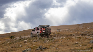


Our arrival at the top was a well-coordinated dance - the pad at 12,800 ft offering plenty of room, but blind from the approach - the appearance being that you're essentially going to drive off into nothingness.

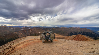
And it's here that I feel it prudent to relate a description of the Red Cone trail from a popular off-roaders resource:
Red Cone is [a] trail that has a reputation for being dangerous, when it is perfectly safe as long as you pay attention. [As you reach the top] there is a one-way, somewhat steep, slippery and narrow, descent that is the area of concern. If you go off you will die, but if you are slow and careful you will be OK.JeepTheUSA
Luckily, none of us were scared of heights - as far as I know. And so after taking in the 360º view around us, we started down the one way section - our engines doing most of the braking on the 26% down-grade.

Red Cone now behind us, and the time nearing 4:30pm, I felt sure that we'd seen our last trail for the day. I mean, earlier we'd discussed also running Radical Hill - a trail just across the valley from Red Cone - but I was sure that the later hour would mean that was an adventure for tomorrow.
Nope. Radical Hill was too radical to wait - and wouldn't take long - promised Brett. So with him leading the way, we set off.

Like Red Cone, Radical Hill started with a steep, rocky section that included a couple of gatekeeper obstacles. While there were more of these than Red Cone, none of them - I felt - were quite as hard. Brett scooted right up, clearly thrilled with the fact that we were finally doing a trail he'd been looking forward to all day.


Then, it was Monte's turn. Once again, having two open diffs wasn't the easiest way to make it up the trail and several valiant efforts followed, a few of them resulting in a bit of scraping of parts we'd all rather not scrape.


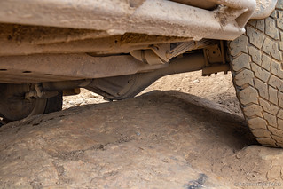
In the end though, he of course made it - his overlanding skillz honed from years of Frank-less driving.  And then, having plenty of time to determine the best line, it was Mike's and my turn to make it look easy as we made it through the first obstacle.


From there, it was more rocky road - litterally, not the ice cream - as we climbed up what had clearly become stream bed when the snow was melting, our trucks bouncing this way and that as we picked the line that most suited our mood.


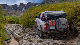
Just as we reached the top of the rocky section we ran into a 3rd gen Tacoma. He'd apparently snuck down the switchbacks we were about to encounter as he and his (girlfriend/wife) had been looking for the "shortest route to Webster Pass from Deer Creek," completely unaware of the craziness they had been in for!
We chatted for a few minutes and congratulated him on his accomplishment before heading up ourselves, past an old mining cabin as we made our way onto the switchbacks.

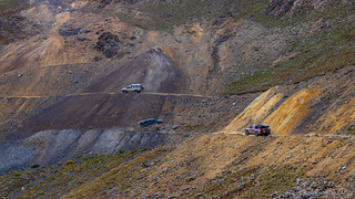
Now, these switchbacks in themselves are nothing all that complex. There's plenty of room for a multi-point turn at the corners, and the road isn't carved into a scree field or anything. However, portions of the trail are - or at least feel - way off camber as well as being washed out on the downhill side and very narrow.
We proceeded slowly, and with extreme caution.


Of course, we all made it - Monte declaring that this was even narrower than the back side of Webster Pass - but not without a casualty. Brett had been hugging the uphill side of the trail so tightly that he'd punctured his front, driver-side tire on a rock. It wasn't severe enough that he had to change it right there on the switchbacks, but he scooted his truck up to the top while the rest of us paused for a moment to snap an #instafabulous photo or two at a top-of-the-world sort of overlook, Red Cone in the distance.


By the time we got to the top, Brett was nearly done with his repair - my suspicion that he'd had help from a couple of mountain goats he found wandering around at the top of the pass.


With everyone safe and sound, and Brett's truck back in working order, we couldn't help but reflect on the adrenaline that was pumping through our veins. It was chilly here at the top of Radical Hill, but it was radical to be here for sure. And we were all ready to find ourselves a camp - hopefully at a significantly lower elevation!


So down along and then down the other side of the ridge we went - first towards Deer Creek Rd and then further east - towards, but not to, Breckenridge. As we did, the sun made its way toward the horizon - peaking under the clouds that had been with us all afternoon - lighting up the hillsides in a warm orangey glow.


We continued down, the road eventually leveling and smoothing out a bit until we started passing other campers as well as a few old mining structures that had seen better days. This cabin is the most visible remains of the gold mining town of Swandyke. With a population of 500 in the late 1890's, the town boasted a 75 bed hotel and had stage coach service to Jefferson via Georgia Pass. In 1898, an avalanche destroyed the mine's mill, after which the population fell to about 20. If you have time, exploring up the hill here will reveal additional cabins and remnants of the town. Oh, and the gold found here was surface gold, so keep your eyes open!

We were, unfortunately, still in Summit County which meant that when we finally did find camp on the edge of a meadow, it was another night with no campfire. Like the night before, we gathered around a tailgate and made the best of the cold situation for as long as we could.
Brett broke out his traditional camping treat - animal crackers, and Monte opened up a container of chocolate chip cookies. It'd been a long, hard, fun day and we all went to bed knowing that there was more of the same to come!

