
It's been over a year since I was last in Idaho, and boy did I miss it! So, after spending a few weeks at home upon returning from the New Mexico Backcountry Discovery Route (NMBDR), and with @mrs.turbodb heading out on a camping trip with her dad, late July seemed like the perfect time for me to whip up a little something in the Sawtooths.
The key word there being "seemed."
I'd been collecting places to go - some of them from roads not travelled on earlier trips, others discovered online one way or the other, and one in particular that I'd seen a trip report from Ben about. With a bit more route planning research, I soon had a nice little loop constructed that would wind through some of Idaho's most beautiful landscape and give me a nice combination of driving and hiking over a five-day period.
That is, if things had gone to plan.
I hit the road around 8:00am on Monday morning. With the sun shining down through a bright blue sky, and only a 12-hour drive to my first camp site, I found myself wondering why I'd been doing the 18- to 24-hour drives of late.
It was somewhere in Oregon that I got my first inkling that the trip might not be quite as idealistic as I'd originally envisioned. It started harmlessly enough - a summer time haze creeping across the landscape. But soon it was clear that this was no normal haze - this was smoke from the Bootleg Fire burning in southern Oregon. Initially carried north, and then east, by the jetstream, I'd heard that it was affecting residents as far east as New York.
I just hadn't put it together that my destination was directly in that path.
I held out hope that it would clear up as I got into the mountains, but as I passed through Banks and into the Sawtooth National Forest, it wasn't looking good.

It was evening by the time I was closing in on Stanley and got my first real glimpse of the Sawtooths in the distance. They were - as I knew they would be - obscured by smoke. I stopped at a favorite rest area to take a closer look.


Already, I was starting to wonder if the rest of the trip was worth doing. After all, I'd planned much of it around the expansive, craggy views that usually blanketed the area, themselves now blanketed in smoke. I decided to leave the decision for later - playing it day-by-day - and fueled up in Stanley ($4.25/gal  ) before heading to the Phyllis Lake trailhead to find camp in the dark.

When I awoke the next morning - climbing out of bed around 6:00am - I'd gotten a good night sleep in this quiet little section of the woods. It'd rained a few times throughout the night, but temps were warm and everything was already dry. The rain seemed to tamp down the smoke a bit, and with only a half mile between me and Phyllis Lake, I decided that there was no better time for a pre-breakfast hike than ... before breakfast.
The trail to Phyllis was in great shape and before long I was standing at the water's edge, staring across the rippled surface at the scree fields in the distance.
For a minute or two I considered walking around the lake, but decided that I had better take advantage of the little bits of blue I saw in the sky and push onward toward the longer, two-lake hike I had planned for the day.


Back at camp, I folded up the tent and polished off a big bowl of cereal before climbing into the truck to retrace the final couple miles of my track from the previous night. Doing so would deposit me at the trailhead to Fourth of July Lake - as well as Washington Lake - a six-mile roundtrip that sounded fantastic.


Soon enough, I was ready for my next trek. Still before 8:00am, I hoped to be back to the Tacoma for an early lunch, at which point I'd evaluate the smoke situation and make a call about continuing on.

As on my first hike, the ground was completely dry after the sprinkling of rain overnight, but the relatively large raindrops had wiped clean the trail, making it seems as though I was the only one who'd passed this way. It was a nice - if obviously untrue - feeling.

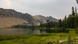
I covered the first mile-and-a-half quickly - but acutely aware that I was hiking at elevations approaching 10,000 feet - and found myself looking out over Fourth of July Lake as a battle between sun, clouds, and smoke raged on overhead.

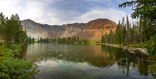
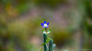
From Fourth of July Lake, it was an additional 1.5 miles to Washington Lake - a distance that every review I'd read, claimed to be so worth it. Of course, I'd have done the hike regardless - my mantra of might as well, since I'm already here more than enough motivation to push me onward. Like the first half of the hike, it was quite pleasant - even with the smoke - and spring was clearly in full swing up here, the ground covered in wildflowers.

I'm not sure what I was expecting at Washington Lake given the reviews I'd read, but of the three lakes I visited, I'd say it was my third favorite! 
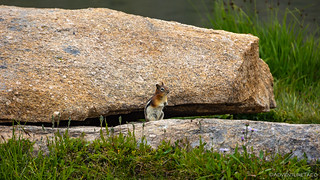
Though I'd been the first hiker of the day, at least one family had camped there the night before and despite what must have been frigid water, the kids were busy splashing about. Their laughs and screams carried across the lake, reminding me of the joy that @mini.turbodb has in similar situations, her parents content to watch from the shorelines; perhaps adding a splash or two to the fun.
I just stood there for a little while enjoying myself, a small inflatable boat - paddled poorly but proudly by a child not over seven - making its way across the water. And then, I spotted movement. It took swift action on my part, but soon I was the proud catcher of this little guy.

I'm all about catch and release - and I don't have any sort of froging license - so after as little terrifying torture as possible, Mr. Tadpole was back in his natural habitat and I was on my way back down the trail.

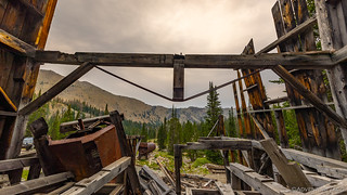
Since I didn't really have a schedule, I arrived at the trailhead right on time. And, having taken a slightly different route back, I was excited to see the ruins of an old mine rail trestle that I'd missed when I'd been here previously. I immediately made the decision that I'd actually arrived early and that I should absolutely check this thing out a bit more closely before continuing on with the rest of my day.


@mrs.turbodb's voice in my head: No.
Well, it turns out that I was right on schedule - for the second time - getting back to the Tacoma. Given that I still wasn't really hungry - it was only 10:30am - I decided to forego the early lunch and press on with the trip. The smoke hadn't seemed so bad thus far, and besides - I was already here. 
The key word there was "thus far," because about 20 minutes later - as I worked my way towards ID-75 - I knew that my time in Idaho was limited. Visibility had decreased dramatically in those 20 minutes, and what was usually a fabulous view ... wasn't.


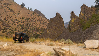
As I reached ID-75, I had a decision to make - turning north would take me home, but where I really wanted to go was south. The next stop on my loop - Boulder Basin - was supposed to be the (driving) highlight of the trip. I turned south.

As I ticked away the 30 miles or so to the turn-off to Boulder Basin, I made the decision that I'd make a run up the trail, then head home. Except that I didn't really decide - I just decided that I'd try to decide when I got to the top.

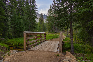
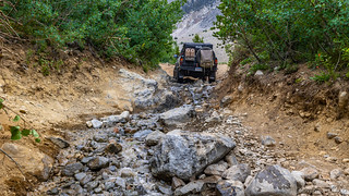
The trail to Boulder Basin is only six miles in length, and the first four of those miles are nothing to write home about. Winding through the forest, the creek gurgling next to the road, it's pleasant and uneventful.


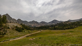
It's right around mile four that the trail starts to climb out of the trees. It never fully escapes the tree line, but the road surface transitions from dirt to rocky scree quickly, and of course ... the views!


Soon, Boulder Creek and the road become best buds, and for much of the remainder of the journey, the going is various degrees of wet.


With the trees thinning, alpine meadows - and more views - abound. It's all 360 degree views up here - or 270 degree when smoke limits visibility down the basin on a day like today.
I knew - from my pre-trip satelite research - that there were old buildings at the top of the basin. What I didn't realize, was that this is the remnants of an old town - once the highest in Idaho - and the Golden Glow Mine. So, you can imagine my excitement when I rounded a bend to see the ruins of an enormous mill.


The road continues a quarter mile or so beyond Boulder City, up through another meadow, before forking to Boulder Lake and one final push to the top of the basin. It was in this final meadow that I ran into the current caretakers of the place - one of them a little less skittish than the other.


It was at the fork in the road where I made a decision. It wasn't the decision about whether to continue the trip or not - that would have to wait for later. Rather, I decided that I'd check out Boulder Lake, but that I'd leave the very top of the trail unexplored until Ben @m3bassman could show it to me. It seemed only fitting given that I would have never known of this place without him.
It was 1:30pm when I pulled the Tacoma up to the lake's edge, and for me, today, the end of the road.


There was a bit to explore here at the lake, and once my belly was full of sandwich and apple, I set off on foot towards a mine shaft a little way up the hill. It turned out to be only 25 feet deep or so, but I imagine it was still plenty of work to carve it out of the hard stone.


And now, finally, it was time to make my decision. I could camp here for the night and decide in the morning if I wanted to continue, or I could head back down the way I'd come and drive late into the night to make it home in the wee hours of the morning.

As I fretted over delaying - or not - the decision, I thought it might be a good idea to listen to the weather forecast, so I fired up the WX channel on the ham radio and waited to hear what things would be like for the next few days. The answer - fortunately or unfortunately - made my decision easy. It was time to go home.
The next few days called for both denser smoke as well as lightning and thunder storms in the afternoon and at higher elevations. Given that I'd planned a hike at 12,000 feet - above the treeline - for the following day, it seemed only prudent to forego the smoke-inducing asthma and possible death-by-electrocution this time around.
And so, I pointed the truck downhill and resolved myself to a long drive. But first, I had to navigate the trail.
The most technical section. Accidentally shot as a timelapse instead of slow-mo, sorry.

With gravity assist in full effect, the trip down the trail was significantly fast than the opposite direction and soon I was aired up and headed north on ID-75 and then west on ID-21 towards home.

In the end, I'd only be in Idaho for 24 hours of what I'd planned to be a five day adventure. Still, those 24 hours had been pretty rad, and I was already wondering how quickly I could return. With any luck, it wouldn't be long!
")


")


Sounds like you headed home just before I got to Challis for a week camping and riding, arrived here on the 18th. I pounded down rain all night had little lakes everywhere around me. Wondering if I would be able to ride the next day due to all the rain and thinking the trails would be super muddy.
We headed out anyway only to find the best trail conditions of the year....No Dust! A few water puddles was all we encountered, great day riding and no smoke. Went up to Twin Peaks fire lookout at 10,394', couldn't go up to the landing or inside the building due to covid as we were told.
Visited many old mines ruins and even had three buck deer in camp about 20 yards away. All in all this is beautiful country with lots of scattered mines everywhere, some accessible and some not.
Go Idaho!
Sounds like a great time Kenny! A bit of rain during the night is always a nice thing in the morning for the dust, and very nice to hear that the smoke is gone now! I've got a few roads marked over there in the Challis area that I was going to visit - and that lead to mines as well - on my last trip, but they'll have to wait for next time (which is fine) when hopefully, there's less smoke.
From my keyboard over here, I think you should have toughed it out...Everyone knows the weatherheads only get it right 50% of the time...And Challis Hot Springs are pretty swell, except for the jerk marine they hired after Bob died..
Anyways, for what it's worth I've spent the past few hours enjoying reading your adventures and photos...
Thanks!
David Evans
Hey David,
Well, it turns out they were correct this time (but I know what you mean! ?). Plus, leaving the hike for later means that I've got an excuse to come back, and I always love getting back to Idaho.
Thanks for reading and I'm glad you're enjoying it. I always love comments (and the conversations they start), so leave as many as you'd like! ?
Cheers, Dan