

We awoke to a morning much like most winter mornings in Death Valley - a smattering of clouds and temperatures in the mid-40s. We assumed - incorrectly, in hindsight - that the day would unfold much like our previous two, though I have to admit that I hoped that we could get through a few more miles of hiking than we'd achieved in Tail Canyon.
Even I knew that my hope was more akin to a dream, but with any luck we'd still be able to get to the hike I'd been anticipating the most on this visit to our largest National Park: Hungry Bill's Ranch in Johnson Canyon. It's not that I'd heard of amazing cabins or mines - in fact, I'd heard quite the opposite - rather, I was curious to see the place where some entrepreneurial man had decided to grow fresh veggies to haul over Panamint Pass and sell to the residents of Panamint City.
But I'm getting way ahead of myself. Like, an entire trip, it turns out! 
Hanaupah Canyon
Before even thinking about Johnson Canyon, our itinerary had us driving up Hanaupah Canyon for a hike to check out Shorty Borden's Camp as well as a few sets of narrows and falls a little further on. I was already a bit bummed - but fully on board - with this plan, since Hanaupah is the route from Badwater Basin to Telescope Peak, but even I wasn't so crazy as to think that we could make such a hike in a single day, especially with snow blanketing the upper Panamints.

What we didn't count on was the condition of the road into Hanaupah Canyon. Where Trail Canyon had been slow-going, Hanaupah had us moving at a crawl. In places, the road had been entirely washed out, and we'd only pick it up again as we navigated our way through boulders in the wash.


It was nearly 10:00am when we finally set off on foot. With a wide wash and gently sloping hillsides even several miles into the canyon, hiking was easy - if trail-less - for the first mile. Winding our way up the meandering forks of the wash, we stopped now and again to admire the local geology and plant life, not always knowing what we were looking at, but full of wonder nonetheless.


(Probably not.)
By 10:30am we'd covered the mile from the end of the road to the location of Shorty Borden's Camp.
Alexander "Shorty" Borden was a prospector who came to Death Valley in 1887, reportedly to search for the Lost Breyfogle Lode. Failing to find it, he prospected far and wide in the Panamint Mountains.
In September 1932 he began constructing the present canyon road to a small silver deposit in Hanaupah Canyon's south fork, which he wanted to develop. Shorty was a great walker, familiar with the hardships of the desert. Using hand tools, burros, and a little dynamite, he completed this amazing 10-mile road in only six months, reportedly at the age of 66!Hiking Death Valley
Despite his futile search for gold and silver, he gained an intimate knowledge of the area, and a bit of fame when he located a water well just off the Westside Road. That site would become known on maps as "Shorty's Well," no small recognition since water can be as valuable as gold in the desert.


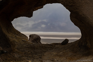
Having neglected, again, to bring my tripod, it was as I was bumbling around with my camera - trying to keep it still for a long enough period of time to get a decent exposure in the low-light of the adit - that @mrs.turbodb so kindly mentioned that it was starting to rain.
Well, damn.

"If there's one thing that makes a good explorer, it's stubbornness," is probably not true. If it were, we'd certainly be in the running for a podium spot. Despite the imminent deluge, we were determined to get to the first narrows before turning around.
There was just one problem: we'd lost the trail, and there didn't seem to be a straightforward route through the thick vegetation that blankets the next mile of wash. Navigation was made even more difficult by a stream - flowing at nearly 200 gallons per minute - that plunges over boulders, bubbles into watercress- and algae-covered pools, and generally makes progress difficult.
Actually, our stubbornness created a second problem as well: we misread the description of how to most easily proceed up the canyon, and found ourselves climbing a several-hundred-foot hillside in an attempt to bypass the worst of the jungle below.
Naturally, by this time, it'd really started raining, and - as stubborn as we are - it was time to admit defeat. Neither of us was wearing a waterproof jacket, and our pants were already soaking through.
It was a left behind canyon, once again. 


Now What?
The long, slow trail into the canyon was only slightly faster in the downhill direction, giving us plenty of time to blast the heat in an attempt to dry our now thoroughly soaked gear. We also used the time to discuss our next steps - really only coming up with two options: continue on with our planned route - and the Johnson Canyon hike I'd been looking forward to - or turn tail and run.

Initially - embracing our stubbornness - we turned toward Johnson Canyon, determined. But, as we sped south along West Side Road, it became abundantly clear that the rain to the south was even heavier, and it wasn't going to blow over anytime soon.
And so, with five canyons planned - and having completed a sum total of zero of them - I flipped the Tacoma around and we headed towards Furnace Creek to get a weather report and regroup.

One of the nice things about the Furnace Creek Visitor Center is that the parking lot has covers to protect visitors from the blazing sun of summer. These covers aren't entirely leak-free, but they mostly keep people seeking shelter from rain while eating lunch dry as well.

Our bellies full and a bit of talk-to-the-information-officer-reconnaissance into the weather, it sounded like the rain would carry on through the evening, stopping only around midnight. That sounded good to us, since it alleviated our major concern - putting the tent away wet on the final morning of our trip - but by this time we knew that heading back out to West Side Road was a non-starter.
Hoping that we could get a camp site a little closer, I inquired about a one of the free, in-person only, first come first serve permits for the Hole in the Wall. Naturally they were gone, but the nearby Echo Canyon (same system) had a few spots available - as long as I was willing to fill out a form that included more personal information that a government background check and convince an "information officer" that, "yes, I really do want to camp in a canyon even though it's been raining."
Slit Canyon
The reason I'd wanted the Hole in the Wall permit was so that we could hike Slit Canyon and then not have to worry about driving too far to set up camp for the night. After talking it over with @mrs.turbodb, we decided that we should still give the hike a shot, since a little night driving has never stopped us before. And so, with light rain still pelting the windshield, and daylight waning, we raced east.

It was 3:15pm when we donned our raincoats - stubbornness doesn't mean we can't learn - and headed toward the mouth of Slit Canyon. As with many hikes in the desert, the distance to reach the canyon was longer than the distance we planned to hike in the canyon, though with a longer hike, Slit Canyon can actually connect Hole in the Wall to the upper end of Echo Canyon (north).


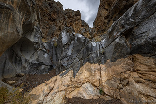
Almost immediately after entering the mouth, the walls of Slit Canyon narrow and three falls present themselves in quick succession. The first - 10-15 feet tall - has two parallel, deeply notched chutes in light gray dolomite. The second fall, banded with black, is around 18 feet high. It is moderately difficult to climb up, worse to climb down as usual, but it gives access to a 25 foot tall, deeply recessed grotto that is entirely smooth and impossible (for these humans) to climb.
After wasting a bit of time climbing the first fall, we decided that we probably ought to find a bypass around the group of three falls, in the hopes of reaching the first narrows - and the slit for which the canyon is named - before it got too dark "for our return trip." (I definitely wasn't worried about light for photographs. Definitely.)


A quarter mile into the narrows, we came to the slit. A straight and narrow corridor, it is a slanted, water-worn trench, cutting a path through the dolomite that is no more than 2 feet wide and 40 to 50 feet deep. Beginning with a pile of chockstones, it goes on for about 70 feet, ending at a 15-foot fall that - in dry weather - can be climbed in order to continue up canyon.
Unfortunately for us, the weather was anything but dry.


After a bit of hemming and hawing about trying to climb out the top of the slit - including a couple of slippery fails by yours truly - and realizing that we had less than ten minutes until sunset - we ultimately decided that this was another canyon that we wouldn't complete on this excursion.
Yep, that meant that we'd planned five canyons, attempted only two of them, added one more, and finished... none. If that's not success, I don't know what is!


We Left What Behind?
As forecast, the rain stopped around midnight and the tent was - thankfully - dry by the time we work up in the morning. This was a bit different morning than most, as - rather than drive 1,000 miles home - I'd arranged to leave the Tacoma at an indoor storage facility in Las Vegas. Doing so would allow us to hop on a 3-hour flight home (and back), hopefully making these trips more about enjoying the desert, rather than enduring a 20+ hour drive to get there.
And so, a few hours later, we were handing over the keys and hoping for the best.


I did a test on some Red Rock Conservation canyons around Las Vegas. I must say I'm pretty impresses with the rear lockers on Mr. Taco. Even without the fronts pulling the rears do a yo man's job. Even up serious small rock/gravel rock inclines she just pushed on up. No big rock climbing, but I know better. This opens up a lot of 'no worry' possibility's for me. If your going to do Warm Springs on your 5 canyon trip, I'd like a trail report on that adventure. Happy Trails! I'm ready to go Geo!
Nice! A locker can definitely help a lot with traction in terrain like that around Red Rock there near Vegas. We just drove by yesterday afternoon on our way to drop off the Tacoma after another successful trip to Death Valley. Great weather and not to give too much away, but you'll note that there's a new placeholder for the trip posted: Left Behind, Again (Feb 2023).
We didn't leave quite as much behind, this time! ?
As always, great photos and adventure. I think we'll have another look at Death Valley in the spring although won't travel those rough roads the way you do, will just have be observers of your travels on those. The idea of leaving the Tacoma in a storage facility is good, I probably wouldn't have thought about that but then we're a lot closer & don't have to drive a long distance. Always look forward to your next adventure! Thanks for sharing again.
As always, glad you enjoyed the stories John!
Death Valley this spring (not too far in the future - March probably) is going to get really pretty, I think. We just returned last night from a few more days down there, and things are starting to green up. No real wildflowers yet, but with all the rain in the fall and December, I think there's a good chance for a nice bloom! Fingers crossed anyway.
Gonna head back down again next week for a longer period in a place I've never been before - Joshua Tree. So easy to hop on a cheap flight to Las Vegas (all subsidized by the casinos, I think) and be off adventuring in a few hours rather than 20+ hours of driving.
Joshua Tree is someplace we haven't been yet but plan to go now the truck is all setup for camping. It's one of those places that is very popular so gets a lot of use.
Yeah, the popularity is something that I've not loved about the area as well. I'm hoping to (mostly) spend my time hiking and in the Old Dale Mining district, where I suspect there will be fewer (but probably still a lot of) people.
From what I've seen online the Old Dale Mining District has a lot of larger scale mining equipment and buildings of interest but the roads looks pretty scary, definitely 4WD. If your trip works out will be very interested in seeing your photos and narrative. Looks very interesting but beyond the ability of my truck! LOL
Oh, man, the title of this series had me worried!! I thought the Taco was going to finally give up the ghost on you, or somehow you'd roll it or...some other catastrophe. Glad she's going to be waiting safe, warm and dry for your next adventure!
Oh, man, the teaser description of this series had me worried!! I thought the Taco was going to finally give up the ghost on you, or somehow you'd roll it or...some other catastrophe. Glad she's going to be waiting safe, warm and dry for your next adventure!
? I did try to make the title a bit of a cliffhanger ?
The next adventure is in the books already, and I think I'll start posting it tomorrow - just need to wrap up a few photos and a bit of the story. I have to say, it went great having the truck down there. So much nicer than the long drive!
There's so much about this next story that I want to share here... but I better just leave it be, and you can enjoy it as it comes out with the photos. ?