
Heading north on CA-99, I was obviously going to have to stop somewhere along the way in order eat lunch. It just so happens that my favorite restaurant in the world is in Turlock, and as I pulled at 11:57am, my timing couldn't have been more perfect.

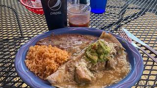
I don't know what I was thinking, but unlike usual, when I order two or three (or more) plates to go, I only ordered one this time, and it was gone way too soon. Still, I must admit that it was as delicious as ever, and after settling up and saying thanks, I was back on the road and headed toward the tiny town of Taylorsville in the Plumas National Forest.
My route would take me up CA-99 through Sacramento where I'd branch off onto CA-70, ultimately following the North Fork of the Feather River. This, also, was the southwest corner of the million-acre Dixie Fire; still burning in places, it had burned through this area nearly 2 months earlier.
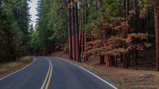
This drive along CA-70 has always been one of my favorites. The canyon walls rise up steeply as the highway follows the river. For me too, it revives memories of my childhood - trips from the Bay Area to see my two - favorite, of course  - uncles who lived in the area, or to go camping at one of our favorite campgrounds in the Plumas National Forest. Today was no different, and as the highway and railway crisscrossed over the river, I couldn't help but wonder what I would encounter just a few miles ahead.


I started to see the aftermath of the fire just after the Elephant Butte tunnel. Trees - on both sides of the highway - were scorched, but the ground was largely covered in pine needles and shrubs were beginning to regrow, so I assumed that what I was looking at was from a previous year's fire. I'd later hear from my uncle that until only a couple weeks before, the ground had been baren, the pine needles having only just begun to fall.
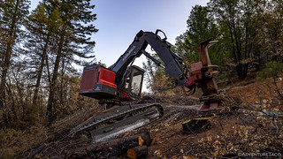
Only a few weeks after the fire had passed this way, the cleanup was in full swing. Several points along the highway were reduced to a single lane as sawyers cut, and heavy equipment hauled away, trees that threatened to fall over the highway.


A little after 5:30pm, I rolled through the last town for the evening. Luckily, fire fighters had been able to save it, and the effort put into the fight was still obvious. Everything on both sides of the road had been sprayed with fire retardant. And, even though the blackened ground was beginning to be covered by needles here too, it was clear that the fire had burned through the area - tree trunks singed black and the normal shrubbery largely gone.
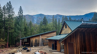
Fifteen minutes later, I arrived at my home for the evening - one of my uncles' places. It'd been a tense several weeks as the fire had burned through their area in the third week of August, an email I'd gotten clearly showing the stress they were under.
Of course, fire talk was a close second to all of the hello's and how-ya-doing's - and soon I was getting a tour of their property - complete with walking the dozer line that'd been plowed in, the sprinklers he still had running in case of another approach, all the work that had been done to reduce the risk of ember infiltration to buildings, and even where he was planning to hide out if fire overran him and the couple dozen fire fighters who were defending the half-dozen houses in the area.

Just as we were wrapping up the tour, I happened to glance up and noted a plume of smoke in the near distance, commenting on how things must still be flaring up now and then. The look on his face - and the neighbor talking to my aunt about the same plume of smoke when we got back to the house - said it all.
The rest of the evening was spent enjoying a wonderful dinner, desert, and each other's company. A new - to me, but probably 10 years old  - single-room guest house even meant that I got to sleep in a real bed rather than deploying my mobile palace.
The Following Morning
I'd planned to leave around 6:00am, but realized as my alarm went off that sunrise wasn't until an hour later - a sign that summer is surely coming to an end - and so I moved slowly with my goodbyes. You see, a big part of the reason I'd come this way was to check out the town of Greenville, and it wouldn't do me any good to arrive in the dark.
Having dragged out the farewells, and with ample understanding that I was welcome any time, I pulled out a around 6:45am, and started making my way toward Greenville. It was clear as I drove around the perimeter of Indian Valley that - as had been the case with the █████ Fire aftermath earlier in the trip - the path of a forest fire really does create a mosaic on the landscape. Some mountainsides appeared untouched, others completely burned - the fire creeping or climbing as fuel sources and wind fed its progress.


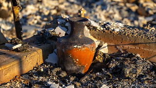
And then, I started to see homes. The ashes of homes, really. And cars. Of everything. At first, it was just a single property, nestled along the side of CA-89. Then it was a small group. I was on the outskirts of town. And then I wasn't.


I didn't really have a plan for when I got to Greenville. I figured that I'd take a photo or two and then be on my way. But as my speed slowed, I found myself turning off the highway and onto what was once a residential street. A few houses - a business or two - and the high school - stood unscathed amongst the rubble. But the vast majority of everything was destroyed.
I wasn't just going to be here for a quick photo. I parked the truck and decided to walk through what was left of town, doing my best to pay my respects to the enormous loss that had occurred.


On a lighter note, for those who understand the market for 1st gen Tacoma's these days,
"FS: $12,500. Minor smoke damage, I know what I've got!"

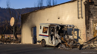

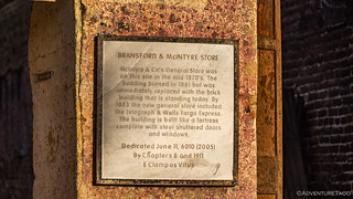
Eventually, I made my way from residential to the business section of town. Here, buildings that had been standing for hundreds of years - built of brick and stone - fared no better than the houses I'd seen elsewhere.


Instead of spending a few minutes, I'd spent nearly two hours walking around town and taking it all in. There was so much that I could never see it all, and even if I could, I wouldn't really know what I was looking at. Here and there, property owners were looking through the rubble, and lawn signs from various insurance companies decorated the landscape, promising to help with the rebuilding process. By and large however, it was a ghost town - one that will take decades to return to its former glory, if it ever does.
Unlike the excitement I'd felt at my Dad's favorite camp site, and the relief I'd experienced at my Uncle's place, the feeling I was left with as I waited to head out of Greenville - a flagger managing traffic as more trees were cleared - was entirely different. A feeling of sadness and for an uncertain future of hope.

Once again headed north, my next destination was home. I had 12 hours or so to get there, and I passed the first couple of those driving through the charred remains of the Dixie - the largest fire in California's history. Along the way, plumes of smoke still rose in the air, teams of CalFire - and other I'm sure - fire fighters still working to tamp down and extinguish hot spots.

Eventually I left the Dixie behind - headed for Mt. Shasta, and then Oregon, before crossing back into Washington. It'd been a whirlwind of a trip, with ups and downs that I could have never predicted before I left home. It was a good reminder to enjoy - and be in the moment - this wonderful land in which we live, because there's no telling what tomorrow will bring and the aftermath that we'll need to work through.


My Shasta looks a whole lot different today.
Fire is so devasting and saddening, it has to be one of the worse disasters ever. Fortunately in Idaho this year we were spared from the all-consuming fires. Our battle now is another very dry year.
Every year is different and we survive them all by the grace of God. We are all hoping for a heavy winter as Northern California is experiencing now with record snowfalls. I am glad your family is okay and that they were spared from the fires.
Our prayers go out for those who lost everything except hope, we shall survive.