
With Pops heading home after a better-than-we-could-have-hoped day at his favorite camp site, I figured that I ought to explore a bit more of the forest to see the effects of the █████ Fire in a few more places that have become special over the years.
And so, after hugs, smiles, and the knowledge that we could return in the future, Dad turned left and I turned right - leaving each other in literal clouds of dust.
Even before we'd headed out, I'd speculated that the likelihood of me ending up back in our same camp site after running into closed roads - be they closed by the USFS or by downed trees - was probably about 50-50, and as I got under way, the trees around me definitely didn't add to my confidence.

I didn't make a lot of stops along the route, for a few reasons. Mostly, I was a little bit worried about the time. We'd parted ways at 4:30pm, and if it took me a couple hours to find a road block, that would mean that I'd be returning to camp in the dark. That's not a big deal, but it's always nice - especially in this place - to enjoy the sunset whenever possible. The other reason for the lack of stops was that the landscape was rather monotonous; brown, burned trees, everywhere. still, as the opportunity presented itself for a bit of a different view, I did try to make the time to take it in. As always, even in a state of destruction, nature can offer cool little sights worth enjoying.


Eventually, the forest began to thin - not because I'd reached some amazing elevation and the treeline, but rather because - as had been the case in our camp site the previous day - the ground was beginning to change to a more granitic surface, less hospitable to a thriving forest. The effect of this change was immediately apparent: as in our camp site the previous day, more and more trees had survived.


Excited that I would surely make it to my planned site at this point, I realized how lucky I was. Deep in the bowels of the █████ Fire devastation, it was as though some of our favorite spots had been saved! I find a perfect spot, with a view of the southern border of ████████ to the north, and set up camp.

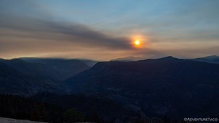
I spent the next couple of hours reading and wandering around the top of the ridge - the views spectacular as usual, though a little smoky for my taste. Eventually, late afternoon turned to evening, and I'm sure that same smoke contributed to the colors spilling across the sky.


With the sun finally below the horizon, I started cleaning up the few things I'd gotten out around camp - my chair, the water, the dry food box - and got my chompers polished up with the help of my electric toothbrush. Normally, this would have been a not-more-than-a-few-minutes operation, but for some reason tonight, it took me nearly half an hour.
Oh, right - because every time I looked up, there was more - or different - color spilling across the sky in every possible direction.


I went to bed with the camera pointed generally south, a photo snapped every 30 seconds or so. My hope was to come away with a fabulous star trail, the foreground illuminated by the waning - but still bright - moon that would rise sometime after 10:00pm.
Alas, while the setup worked well and I awoke to photos snapped through the night, the wind picked up about the same time that the moon rose, and only a few of the photos were crisp enough to use, the camera shuddering as the gusts blew over the ridge. No matter, with a set of earplugs and my extra-comfy Exped Megamat Duo, I slept like a baby through the entire night.
The wind had been coming from the east, so when I awoke in the morning - before sunrise as usual, and because I knew I had a long day ahead of me - I was definitely a little surprised to see that it had gotten smokier than any other time during this trip. I'd have expected and easterly wind to clear things out, but the weather can be a strange beast, I suppose.


It was only a few minutes after sunrise when I climbed into the truck and started back down ███████████████. In front of me, the ridges in the distance, danced in and out of the high layer of smoke, sometimes visible as towering ghosts, other times, obscured completely. It was probably a good thing, as it meant I wasn't constantly stopping for photos as I worked my way down the mountain.


 off-camber.
Having descended the trail significantly faster than I climbed it the previous afternoon, I reached the bottom and noticed a fork that I'd always put off "for next time," on previous trips. Well, I decided, there was no better time than the present - after-all, it'd been more than a year since I'd last been able to visit.
So, I headed up.
Of course, the landscape was nothing like what it would have been had I made this trip on one of my previous visits to the area. Like much of the rest of the forest, the █████ Fire had obliterated much of the life here, resetting the lifecycle and tipping the scales in the favor of ... whatever grows back first!


This trail was quite a bit shorter than the others I've explored in the region, and didn't terminate in nearly the views of what have become some of my favorite places. Still, it was nice to finally answer the question of, what's up that road? If everywhere were spectacular, then everything would just be normal.


And so, back down the road I went - my exploration nearly complete and my sights set on a long drive north. As I headed out, I made one final stop - at a bridge I've crossed many times - to witness once again how things can change in a heartbeat. It'll likely be another year or more before this is rebuilt, allowing easier access to this area.

From here, I had some 8 hours before I'd reach my next destination - thematically similar to this one, I was about to see a small slice of the aftermath that California's Dixie Fire had left in its wake.


Heartbreaking, isn't it? Glad to see some survivors tho. Now, let's plan next years canuckistani trip!! lol.
Thanks for photos even though I am crying over the loss of so many trees. I am a tree-hugger so its painful but I have wondered how bad it was up there. Your writings are really extremely well-done. Maybe one day you'll write a book about your adventures. Let me know if it ever happens, I'd love one signed by my fav tour guide person, and the mrs turbo too.