It was 10:00am and I found myself wondering - did I really just blow up my rear diff? Seriously? While I'm all alone and have to meet Ben and Will in an hour and a half? What am I going to do?
So let's rewind and figure out just exactly how I got myself into this mess in the first place... shall we?
You see, while @mrs.turbodb and I had been exploring the eastern Mojave, I'd gotten an offer from Ben @m3bassman to tag along on a trip he was planning to run the White Rim Trail in the Island District of Canyonlands National Park.
With a plan to meet in Moab on Thursday just after lunch, I set out on the long drive south Wednesday. My plan was to arrive late, sleep in the next morning, and then make my way into town when Ben and Will showed up. Everything was going to plan as I passed through snowy Oregon, and even as a beautiful sunset spilled across the sky in Salt Lake City.

It was slow going in Oregon - for some reason, the highway wasn't well plowed through the Blue Mountains.

Salt Lake is always striking it seems, no matter the time of year!
But as I made my way south I found myself thinking... which is, I admit, dangerous in most cases. I found myself thinking - could I make this trip even more epic? The answer - of course - was yes, yes I could. I traded a few messages with @mk5 and by the time I was all settled in camp, I had a plan for the following morning, and I'd need to be up at sunrise.

I admit to having turned on the tent lights unnecessarily for this morning shot.
Having gone to bed at 11:30pm, I set my alarm for 6:00am - about an hour before sunrise. Anticipation got the better of me however, and I think it was 5:00am or so when I awoke for the final time - though I did manage to stay warm under the covers until my alarm finally went off.
After a few photos of camp, I decided that I'd hold off on breakfast - it was rather cold here on Entrada Ranch Road just off of UT-128 - and I set about stowing the tent and getting ready to go. Just before the sun crested the horizon, I was on my way - covering the last few miles to the Top of the World trailhead.
Now, my understanding - given that I've only heard about this famous trail prior to this point - is that increased traffic over the last several years, has caused the trail to get rougher and tougher. As such, the lollipop shaped trail now requires something on the order of four hours to run; longer if one takes a leisurely pace or encounters any sort of trouble. Figuring that I'd given myself five hours to run the trail and travel an hour into Moab to meet Ben and Will @willhaman21, I knew I was cutting it a bit close. Still, I enjoyed the trail up, hopping out here and there for photos, the Tacoma soaking up the small ledges and rough bits of the trail just fine.

Stepping up.

A rare shot from the front.

More steps, I guess.
Overall, I'd say that the trail benefits from some driving experience, paying attention to line choice, and perhaps a bit of lift, but there was only one obstacle where I got out to make sure I was positioning myself appropriately. It was just after the loop section of the lollipop started, and there was a reasonably tall, steep, narrow, and slightly off-camber ledge that needs to be climbed.

I picked a good line and even stopping to get out of the truck, I just kept crawling up when I got back in.
Even this section was reasonably straight forward - 4wd, but no locker required - and after a few photos I was plodding my way to the top again - a summit I reached right around 8:45am, about an hour and forty five minutes after leaving camp. I have to admit that I was slightly relieved at the difficulty of the trail, especially given my solo status.

I've arrived!

An interesting perspective.
My next order of business was getting right up to the edge. Of course, I've already given away that I was able to do it in the photos above, but it probably took a good 10 minutes to get into that position. You see, the ledge on which one must drive is angled up just enough that - in conjunction with the hood of the vehicle - you can't see shit. And let me tell you, it's not an enjoyable feeling to drive where there appears to be no ground.
With no spotter - and let's be honest, had @mrs.turbodb been there, she would have told me in no uncertain terms she was just going to get out of the truck and stand somewhere significantly safer, rather than spot me - I had to improvise. I found a few rocks and placed them where I wanted my tires to end up - you know, a foot from the edge. Still, I couldn't see the rocks, so I found a few branches that I lined up as markers to guide me in.
It all worked splendidly as my heart raced and I gingerly applied my foot to the gas pedal. I was also quite methodical once I hit the rocks - keeping my foot firmly on the brake until I triple-checked that the engine was off, the truck was in reverse, and the e-brake was as tight as I could get it.
What a rush.

I know, this is not a very original photo.
I spent the next hour taking photos from various angles. With the tripod and without. Exposure bracketed. Using different lenses. I probably ended up with a hundred photos of the same darn thing, when just a couple would have been fine... since all I really did was make my editing life difficult as I picked through the results.

I know, this isn't very original either.
When I was all done, I realized that the real beauty of this place wasn't actually with me or the truck in the photo, but is of the valley below the overlook. The colors there - maroons, greens, oranges, and yellows - were so brilliantly contrasted against the blue sky and white snow on the La Sal Mountains.

The real gem.
Of course now - being nearly 10:00am - I had some ground to cover, if I wanted to get back to Moab by noon. So, I popped in the truck - still breakfast-less - and proceeded to begin my turnaround maneuver.
Naturally, I'd failed to really look at what was behind me - knowing only that it wasn't the thousand-foot drop in front of me - and I pretty quickly found more resistance than I expected. Out of the truck to take a look, it seemed my rear passenger tire was simply in a bit of a hole, so I got back in and applied a bit more throttle to the situation. Nothing but wheel spin, and then I heard a small pop from the rear end.
Hmm, I wonder what that was.
Figuring I probably just needed to pull forward a bit for a little momentum, my heard sank as I heard a pop-pop-pop as I rolled forward. It was 10:00am and I found myself wondering - did I really just blow up my rear diff? Seriously? While I'm all alone and have to meet Ben and Will in an hour and a half? What am I going to do?
I knew that at the very least, I wanted to get onto level ground, so I pulled forward a bit for a different line, and then backed up - the rear end popping the entire time - until I was in a spot where I was out of the way of anyone who might happen up the trail, and I got out to look. It took a few minutes, but to my enormous relief, I discovered that the rear mud flap had gotten bent forward towards the rear tire, and the bolts that secured it to the bracket were catching in the lugs, resulting in the pop-pop-pop sound ever time a lug went by. I don't know if I've ever felt a bigger sense of relief - except for maybe the time where we escaped the mud in the Alvord Desert.

From We Don't Want to Pull Anyone Out; perhaps the only time I was more relieved.
Well, I now had even less time to get down the trail, but I didn't care. If I was late, at least I still had a rear diff! So I set off, promising myself that I'd refrain from any picture taking in order to make up time.

This photos is not helping me get down faster.

I couldn't pass this one up.

Out of the truck again, I'd clearly broken my self-promise.
Even having gotten out of the truck several times, I was to the Dewey Bridge by 11:08am, and knew that I'd probably be able to roll into Moab right on time, if I could just refrain from stopping along the way for photos.
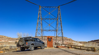
Dewey Bridge was destroyed in April, 2008, by a 7-year old boy. He was camping with his parents about a quarter-mile away, wandered away from camp, and started a brush fire with matches. At the time, the suspension bridge was the second-longest west of the Mississippi; only the Golden Gate was longer.
As I pulled onto pavement, I texted Ben and Will to see if they were in town yet and let them know my ETA. Of course, they were running early and mentioned that they'd easily be ready by noon. Yep, I'd be skipping lunch too.

Can't even resist photos when running late.
I think it was 12:15pm when I pulled into a Maverik gas station at the north end of town, and Ben and Kirsten pulled in right behind me. We said our hellos as I refilled the tank, and before long we were headed north up UT-191 to join up with Will and Angie as we headed out Potash road.

As if Will's 3rd gen 4Runner wasn't enough of an outlier on Tacoma trips, this time he brought his 2nd gen Tundra.
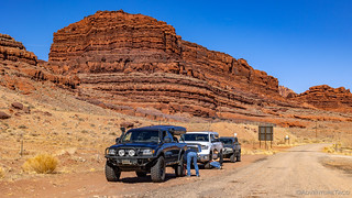
Soon enough we hit dirt and it was time for the rest of the gang to air down.
Our plan - well, really Ben's plan that Will and I were tagging along for - was to make our way out Potash Road to the White Rim Trail, and then follow it around in a clockwise direction for the next couple of days. Along the way, Ben had a series of offshoots we'd follow, some waypoints that were not to be missed, and even a few short hikes to keep things interesting.
Of course, things were interesting right from the get-go for me, with Jackson Butte rising up across the Colorado River, not far into the trail and the landscape in general making it difficult to travel more than a few hundred feet without feeling like, I should really snap a photo of that.
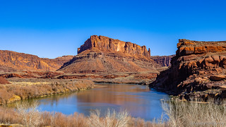


Our first climb towards the white rim.
Before long, we were passing the Potash ponds. Primarily used as fertilizer, potash was originally mined through traditional underground mining techniques. This was dangerous and difficult and now solution mining is used. The old underground mine workings are flooded with water, which dissolves the salts (of which potash is one). The dissolved solution is then pumped to the surface and placed in rubber-lined solar evaporation ponds. The sun evaporates the water and leaves the potash, as well as common table salt, behind for recovery. (BLM informational sign)

Now that's some blue water. I'll stay over here though thanks, no need to get that salt on my frame.
We continued out Potash Road for longer than I expected, though I must admit that one of the really nice aspects of this trip was that I was simply along for the ride - Ben having figured out the entire thing.

The first of many towers. I won't subject you to photos of every one, I promise.

Still relatively close to the Colorado, the La Sal Mountains rising up in the distance.
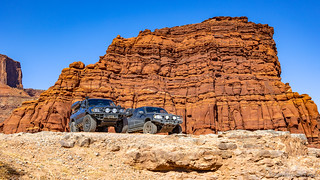
Green trucks.

Nooks, crannies, and lots of levels. We'd wind our way in and out, up and down over the course of the trail. Fantastic!
Not yet to the main attraction - or at least - the trail for which we'd come - Ben pulled over at one point and started walking toward the canyon edge. He clearly knew to expect something that I didn't, and it was a tremendous surprise to reach the edge and see a spectacular horseshoe bend in the river! We'd see a few of these along the way, but this first one was the most impactful for me, because I was caught completely off guard.

Horseshoe bend. Eventually - once the river erodes the narrow finger - no water will traverse this inefficient route.

Ben is in a happy place.
And then, it was back on the road - not long now until we'd reach the intersection with the White Rim Trail, the oranges of the canyon walls, begging to have their photo taken.


We've arrived.
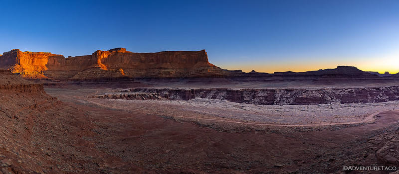
Once on this hundred-mile-or-so trail, which was originally constructed by the Atomic Energy Commission in the 1950s to provide Uranium production during the Cold War, we found ourselves thankful that there were few Uranium deposits found in the area; relegating the trail to its status of "destination" rather than what it may have otherwise become: power plant access! The views along even this initial part of the trail were amazing, perhaps more-so as we weren't yet numb to the grandeur.
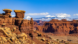

Along the way, we'd take a few spur roads, the first of which was to Gooseneck overlook. The Gooseneck wasn't all that impressive - at least in my opinion - but after several recent trips where I've encountered hundreds, if not thousands of bighorn sheep etched into rocks, it was nice to see a few prancing around in person.

Next along the way was the Musselman Arch. Hard to photograph because it's in plane with the surrounding land mass, I bet it'd be a thrill to walk across. Of course, while this may be something our parents would have done, it's now a frowned upon practice - for both safety, but also preservation reasons. Remember, there are plenty of extra people in the world, but only a limited number of these arches! 
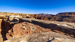
Five feet thick, six feet wide, 187 feet long - and 300 feet down!
I should note that we were making terrible time on the trail at this point - everyone feeling the same way I did, wanting photographs at each bend in the road.

Not sorry I stopped.

Amazing light reflecting back up onto paper-thin sandstone fins.
We tooled along for a while, eventually coming to the intersection with Lathrop Canyon Road, were we headed down into the canyon, the trail weaving in and out of the wash, deep undercuts in the sandstone cliffs overhanging the trucks as we sped along.

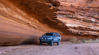
If it hasn't collapsed yet, I should be OK. Right?

The closest we'd get to the Colorado.
After heading back up Lathrop Canyon to the White Rim Trail, it was getting a wee late - perhaps a little after 5:00pm - and I think we were all ready to get to camp at a little place called the Airport, which Ben had reserved for us. Of course, as I turned off the trail - having fallen behind as usual taking photos - I noticed that Ben and Will were already setting up their tents, and the moon was rising up in the east.
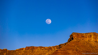
Our first moonrise. We'd enjoy these each and every evening, and nights were bright under mostly clear skies.
I too got my tent set up quickly once I got to camp, but not before the sun dropped behind a tower to our west, the temperature dropping dramatically as it did. We all quickly donned our warm clothes, and figured that we might as well get going on dinner - an easier proposition when there's still daylight!

To say that dinner went uneventfully would be like saying that there was nothing exciting about my trip to Top of the World. About halfway through cooking, we all looked over at Will as his camp stove burst into flames. Thinking quickly, he hurled it from his tailgate to the ground, just as Ben ran over with his fire extinguisher to eliminate the danger - a good reminder of the importance of that safety device! Nothing was hurt except the stove, luckily.
With cold setting in and dinner complete - Will and Angie having finished cooking on Ben's stove - we gathered around the "camp lantern" (there are no fires permitted in Canyonlands National Park) to chit chat about the day and how life had been treating us since our last trip together nearly 18 months earlier. With no heat and temperatures continuing to drop, we didn't last long - it was probably only 9:00pm when we all called it quits and scurried for the warmth of our tents.
It'd been a fabulous first day, and I for one was excited that there were two more to come!
The Whole Story
Love Canyonlands? Check out
Canyonlands Index
for all the amazing places I've been in and around this special place over the years.



I've been looking forward to this one, great photos and stories as usual. Now hurry up and post day 2!
Thanks Ben! I forgot that there was a bit of a teaser with the trip summary page, LOL. Day two (and three) are going to be a few days away... as I'm uhh... well... back down in Utah!!! ?
I'm looking forward to this trip report. The White Rim Trail is a bit of a unicorn for me. I've had it planned the las two years and each time it has been not happened at the last minute. The first time something came up at work that I could not get out of. Then COVID decided to cancel it on us last April.
Another great trip report and photos.
Glad to hear you enjoyed it Lapsley! More coming for this one in a few days. ?
Ah, now you are in my territory! Glad you could make it. Wonderful pictures, and I'm glad you spotted some bighorn sheep. I see them there frequently in winter and spring. I admit, I was expecting a photo of your rig on the edge of the Colorado overlook, not far from Musselman arch. It is an iconic shot and you can get a good view of the rig on the edge of the cliff a bit to the north. But as you pointed out, it can feel like a kid in a candy store driving the picturesque trails of Moab and fighting the urge to to stop everywhere and take more posed photos of spectacular scenery. One never grows tired of those vistas of red endlessly variegated rock formations, snowcapped La Sals and Henry Mountains, green foliage on the edge of the pale green rivers, with tawny tan Bighorn moving about the landscape as a bonus, as if they were being paid to give first time travelers that extra measure of delight. This place tends to get under your skin, no?
I will say your green rig contrasts well with the redrock of the area. And you picked a splendid time to go. Yes, nights are chilly, but you probably didn't see a lot of vehicles, I'm guessing. And you got to experience some scattered spots of snow and probably some icy sections in the shade. I did the full 105 miles of the White Rim last this very week two years ago, 2019, the first few days of April, and we saw only a handful of vehicles and few after Musselman or Lathrop. Speaking of Musselman, as you mentioned it, in the 70s I remember seeing photos in Four Wheeler magazine of a tidy row of topless Jeep CJ-5s parked and posed on the arch, with barely a foot of stone buffer on each side. The 70s were crazy times. As you mentioned, now the park discourages even humans from traversing the arch, much less vehicles. Probably a good idea. It is a long way down. But in the 70s Jeeps would actually drive across it. A different world. A different time.
Hey Mark, happy to hear you enjoyed the story! It’s true that you really never can get tired of the rainbow of colors in Utah. I now wonder about that overlook you were thinking you to see a photo of our trucks at, I don’t even recall seeing it. One of the things I realized as this trip was ongoing, was that even though I didn’t planet, I wish I done a bit more research about what was along the way, just so I knew a little bit more about what I was looking at and four. I realize that it is one of the nice parts of route planning, and also of having a passenger along who can do the research as the trip progresses, to provide color and history of the places we visit! Hope you enjoy the rest as it’s posted and are able to get out to enjoy yourself!
I recognize some of the towers and cliffs. I’ve made love in some of these spots. Thanks for the trip down memory lane. Glad you’re having a good trip!
Hi John, nice to hear that this took you for a little trip down memory lane. It’s always nice to have someone connect with a story like that. Hope you enjoy the rest of the trip as I post it! If you’d like, you can make sure to be notified when I do, bye signing up here: Don’t miss the next adventure!
The odds that some of us are planning a fall Canyonlands trip and you just happen to have gone on a trip there! Cant wait to read the rest of the report. Definitely taking some pointers from this one.
Nice! Glad to hear that you're headed to Canyonlands - any of the districts are great, so I'm sure you'll enjoy it. Are you headed to Island in the Sky, or one of the others? Having now been to all three (once each), it'd be hard for me to pick a favorite. Anyway, here are all the trips I've done to the park, if you haven't seen them: Trips to Canyonlands National Park.
Planning on Island in the Sky White Rim Trail. However we dont want to rush it. Even then looks like 3 maybe 4 days can complete it and explore? Thats why I'm interested in your take since from your past write ups you like to take your time. Even at 4 days, we'll still have some time left over. Might take the group to Top of the World and something else near Moab and southern Utah. Unless its decided to try to sneak in a back country Elephant Hill trip.
Awesome, have a great time. I would say that three days on White Rim is a great amount of time and will definitely let you explore around. Take as many of the side roads and trips as you can, we only took a few and they were all great.