

Ever since we visited the Siskiyous back in 2023, I've wanted to return to explore the northern reaches of California, west of Mt. Shasta. This region - dominated by the Klamath Mountains - contains so many gems, including the Trinity Alps, Mt. Eddy, Tamarack Lake, Mt. Shasta, and a favorite that we've hiked several times: Castle Crags.

After finding a route on Overland Trail Guides that Ben had put together - some 300 miles of backroads through this magical area - we pretty much stopped our "where are we going next" search; the answer was obvious.
It was going to take us about 10 hours to reach the trailhead, so we woke up early and were on the road by 6:00am. We'd follow a once-familiar route down I-5, stopping for food and fuel at the places we frequented often prior to storing the Tacoma in Las Vegas over the winter. Our last stop - to pick up sandwiches for dinner at a Jimmy John's in Grants Pass - was right around 3:00pm, which gave us just enough time to reach the start of the route, and embark on our first detour.


One of the great things about writing up our adventures is that likeminded folks - who often have a connection to the places we go - sometimes reach out to share a story or photo. I love it when this happens, because - for me - it adds a lot of meaning and historical context, which I appreciate and enjoy. And of all the folks who've reached out over the years, one I've conversed quite extensively with is Cliff @Skidoo. Even more than I have, he has explored deep into the backcountry of the western states, discovering cool trails, old mines, and all manner of rarely seen views. So, when Cliff was kind enough to share with me the location of his family's old mine a couple of years ago, I filed it away for safekeeping, knowing that if I was ever in the area, it was definitely something I wanted to check out.


While I'm not quoting Cliff directly, he was kind enough to provide all of the information I have about the mine. I've redacted portions to keep his family's property a little less exposed. If there's enough here for you to identify where it is, please respect it in the same way.
The ████ Mine was a family-operated gold mine located on █████████ Creek, approximately halfway between Eureka and Weed in Northern California. It was originally staked by brothers Erwin and Cliff Sr. in 1930 who actively worked it for the next decade as their primary means of livelihood during the Great Depression. The area had previously been mined in the 1800s, so much of the easily accessible gold was already gone; what remained required intensive labor to recover.
The work was divided into two main efforts and across multiple claims. The first - and primary - method of mining was a series of placer claims along the creek. The second - a few miles from the placer workings - was a hard rock mine, where explosives were used to excavate a 150-foot adit and shaft in search of gold.
In the early years of the mine, it was twelve miles from the nearest town/road, so all supplies and equipment came in by pack mule. The mules were loaded at █████████████████ in the town of ███████████████. The town was a 7-hour round-trip hike, so resupply happened once a month or less.

Our first stop was at the site of the old cabin - eventually removed by the USFS in the 1960s - and the placer mining claim.

Here, water was diverted upstream and routed through hand-dug ditches and flumes along the canyon walls at a very shallow grade. These channels required constant maintenance to ensure a steady flow of water, but when working properly they were several hundred feet above the canyon floor when they reached the mining area. The water was then piped steeply downhill to generate pressure; every 100 feet of vertical drop equated to ~45 PSI. This high-pressure water was directed through a large nozzle called a "Giant," which blasted sand, gravel, and boulders into a sluice box fitted with riffles. Heavier gold settled into these riffles while lighter material washed away. Large boulders that couldn't be washed were lifted out using hoists or undermined.


I knew from emails that Cliff had shared that there was a marker at the mill site of the hard rock mine, so after a bit of time marveling at all the work that'd taken place on the riverbanks, we jumped back into the Tacoma and headed further upstream.
It was the mid-1930s, when Erwin and Cliff Sr. began work on the hard rock mine at the end of a nearby box canyon. There, a 150-foot tunnel was dug and a shaft was sunk, originally with the help of dynamite and later using sticks of ammonium nitrate with fuel oil added on-site (essentially ANFO), which was easier to obtain.
Cliff Sr. and Erwin stopped mining when WWII broke out and the US Government banned gold mines from operation. This shutdown had a lasting impact on gold mining across the country, as tunnels flooded or caved in, and since much of the mining equipment was salvaged for the war effort.
While many mines did not reopen after the war - it was too expensive or the companies had gone broke - Cliff Sr. and Erwin did return in the mid 1960s, though by that time, mining had become a hobby rather than a way of life. It was then that the USFS began creating roads - in order to log the surrounding area - and the family benefitted from a bit of dozer work, in order to more easily gain access to the quartz vein.
Several years ago, Cliff's family visited the site as part of their annual assessment work, placing new posts and papers indicating the corners of the claim.


The sun was only inches from the horizon as we wrapped up our exploration of the old mine site. Keen to find camp before it was completely dark, we pushed deeper into the forest, following a route that Cliff had suggested would have suitably nice views for the night. And sure enough, as we neared the end of the old logging road, an old platform - cleared by the 2020 fire - sat waiting for us. There, under the twilight skies, we enjoyed our sandwiches before climbing into the tent for some overdue shut eye.

The following morning...
With the full route ahead of us, we were up (just) before the sun to get the tent stowed and the Tacoma pointed in the right direction. We also had a bit of a look around camp, since we'd been focused on dinner and shut eye when we arrived.


Throughout the day, we'd generally be working our way east toward Mt. Eddy, through the Salmon and Scott Mountains. We'd hop from one amazing view to the next, punctuating each one with a climb to a fire lookout, high-alpine lake, or - since you can't win them all - the occasional road closed sign. First up was a 3,000-foot ascent from the banks of the Salmon River to the 80-foot-tall steel tower of the Blue Ridge Fire Lookout.


Constructed in 1934, Blue Ridge Lookout stands at an elevation of 5,917 feet. It features an imposing 80-foot Aermotor steel framework topped with a compact seven-by-seven-foot observation cab. This engineering design makes the structure exceptionally rare; it is one of only three such towers ever built in the state of California. Its extreme height was required to elevate observers far enough above the dense, surrounding timberline to guarantee a clear, unobstructed line of sight across the complex mountain terrain.

The remote outpost took on a vital national defense role during World War II when it was integrated into the Aircraft Warning Service. During this time, observers braved harsh winter conditions to staff the tower around the clock, scanning the northern skies for potential enemy aircraft. Staffing continued until the late 1990s, at which point its proximity to other more hospitable lookouts resulted in its decommissioning.


Bummed that we were unable to climb the lookout - especially since all the info we had suggested it was still staffed - we poked around the old structures for a hint of the past. Both were essentially empty, their contents - and windows - being relieved of duty in the preceding decades. Still, the views up here alone were more than enough to make it a worthwhile stop along the way!


We didn't realize it at the time, but if we'd known to look southeast, we could have seen our next destination as we were leaving the first; a hint - perhaps - as to Blue Ridge Lookout's demise.
Less than five miles away, Eddy Gulch Fire Lookout sat perched several hundred feet higher, overlooking much of the same terrain. In fact, we'd learn, the spotter at Eddy Gulch had monitored a fire on the Blue Ridge hillside two days earlier!

In 1913, Hallie Daggett accepted the job at the Eddy Gulch Lookout, entering the history books as the Forest Service's first woman lookout (1913-1927). At a time when men dominated the workplace, this act took special courage, self-confidence, and a true love for her country. Those qualities opened the door for other women to follow. One in particular was Nancy Culbertson. From 1960-1991, Nancy sat atop this mountain with the same devotion and selflessness as did Hallie. commemorative plaque
We spent about twenty minutes talking to Rob along his catwalk - getting a lay of the land and a good-humored chuckle at our surprise upon finding the previous lookout unstaffed - before excusing ourselves for a quick breakfast on the tailgate of the Tacoma, with another amazing view of the terrain that we'd spend the next several days exploring.

Our bellies satiated for the moment - and having made slow progress through the morning - it was time to put a few solid miles of the route in our rear-view mirror. And for my passenger, it was time for a mid-morning siesta. So, we plugged along for a while, winding our way down from the ridges to the valleys, eventually finding ourselves in Carter Meadows.


We also got our first view of Mt. Shasta, which we incorrectly identified at the time as Mt. Eddy. We would feel a little silly about this later - because there's no question about the tallest mountain around - but the almost complete lack of snow on the slopes of this 14,163-foot volcano threw us for a loop!

And then, it was a bit of pavement - purportedly the longest stretch on the entire route - taking us into the only real population center of the entire trip: Etna.

The settlement of Etna began in 1853 with the construction of a sawmill to support the regional resource boom, initially taking the name Rough and Ready. A flour mill erected a mile away in 1854 was named Aetna Mills, and a small community quickly developed around it. During the severe winter of 1861-1862, a devastating flood completely destroyed the original Aetna Mills site, forcing the surviving businesses and the post office to relocate to the safer Rough and Ready mill site. The consolidated town retained the post office name, eventually shortening the spelling and becoming officially incorporated under its current name in 1878.
The early economy relied heavily on agriculture and lumber, in addition to its role as a critical trade hub for the surrounding mining districts. Merchants like the Denny Bar Company established extensive operations, running massive pack trains that hauled mail, heavy freight, and essential supplies over treacherous mountain trails to remote mining camps. Another major industrial driver was a local brewery founded in 1872, which utilized regionally grown hops to produce beer that was distributed by horse and wagon teams across northern routes until federal prohibition forced its closure in 1919. This diverse commercial foundation allowed the community to remain a stable trade center well after surface gold deposits were exhausted.OTG waypoint

We may have skipped Etna entirely if it were not for the fact that I grew up on a street with the same name. Plus, it afforded us the chance to cringe at California gas prices - even if they weren't all that bad - at $5.99/gallon.
It's here that I should note - for all those who love to complain about gas prices in California - the prices in the Seattle area are higher, but we rarely fill up the Tacoma in Seattle. Instead, we go to places like Canada, where gas costs upwards of $1.90/L ($7.28/gallon). We don't have it that bad south of the border, it seems.
From Etna - located along the edge of the Scott River Valley - we followed the river south toward Callahan, and our next detour from the route. Our third fire lookout of the day. The best of the bunch. Bolivar Lookout.

Part way through the valley, piles of river rock caught our eye. Piles. We knew what it was immediately, and soon @mrs.turbodb was flipping through a book she'd checked out of the library, looking for the history.
Mineral production became the defining characteristic of the waterway in 1850 when John Walter Scott discovered gold at a site that quickly became known as Scott Bar. This find initiated a massive influx of prospectors, prompting the renaming of the entire river system.
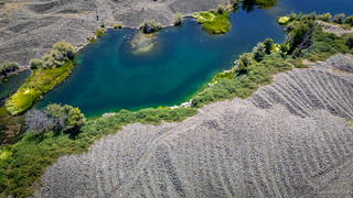
The drainage proved to be incredibly rich, yielding vast quantities of gold through decades of intensive extraction. Placer mining along the banks expanded into large-scale hydraulic operations that blasted away entire hillsides. Eventually, massive floating bucket-line dredges appeared in the 1930s and 40s, using cast iron buckets that hogged out 9 cubic feet of material per scoop. These systematically dug up and overturned miles of the river bottom, extracting millions of dollars of gold, and leaving behind extensive fields of gravel tailings that permanently altered the river channel.
OTG waypoint

It was just before 2:00pm as we slowly rolled through Callahan and onto the road that would take us nearly to the top of Craggy Peak, 5,700 feet above the river gravels. We always like to find things to see that are near but not on the routes that we follow - off the beaten path, they are often gems - and Bolivar Lookout was a place I'd found as I'd scrutinized satellite imagery before we'd left home.
The risk with places like this - unvetted by the route planners - is that they might be closed anywhere along the way. That's not a big deal if the closure is close, but can be disappointing if a gate is discovered after an hour of slow rocky roads. Ask us how we know. 
Today, as we climbed through the woods, the roads seemed to be in recently-traveled condition. A fine, relatively deep - perhaps 3-4 inches - silt covered most of the road, and signs of recent grading were everywhere.
Initially, we thought they were getting ready to start logging, but as we climbed out of the unburned part of the forest, it quickly became evident that the logging was already well underway.


We'd later find out that they'd been working all summer, but that we'd arrived just after stopping time - 1:00pm - when higher winds and hotter temperatures forced work to stop due to increased fire risk.
For now though, we continued our climb.

One of the benefits of the well-appointed Tacoma is that it allowed us to reach Bolivar Lookout - or a parking area just below it - twenty minutes after departing Callahan. This didn't feel outrageously fast to us, but Kay - who was staffing the lookout and followed our dust trail - was suitably impressed.


Though we still had plenty to do before reaching camp for the night, we ended up talking to Kay for nearly an hour. She was a wealth of information about the surroundings, and wanted to share the stories of several visitors she'd had over the course of the summer. Plus, we all had a good time watching her neighbors - a group of California Ground Squirrels - as they played around the base of the tower, surely hoping that we'd drop a snack or two in their direction.

Eventually - after offering a few chocolate treats as a token of our appreciation - we bid Kay farewell, ate a quick lunch at the Tacoma, and were back underway.

After racing our way back down the mountain, we rejoined the main route at 4:00pm, ready to check out a couple more spots before climbing to - what we hoped would be - a campsite with commanding views atop Scott Mountain. This would set us up well for the following morning, when we were planning to shed our in-car attire for our day-hiking duds (technically, the same clothes), for a 9-mile hike to the top of the tallest mountain in the Klamaths - Mt. Eddy.
First though, we wanted to stop at Kangaroo Lake.
Sitting in a glacial cirque at 6,500 feet, the lake is deeper than most at 110 feet. Steep, iron-rich peridotite and serpentinite cliffs tower over the southern shores, while the shallower northern slopes form a unique botanical special interest area, where cold, spring-fed fens support rare insectivorous pitcher plants and dense stands of specialized conifers that thrive on the harsh mineral soils.
There was only one problem: it seemed like everyone else wanted to stop there as well! It probably didn't help that we'd shown up on a Saturday night, but as we pulled through the day use parking area toward the campground, every single space was occupied. Seeing the same story in the campground, we decided that this wasn't the place for us, so rather than getting out and following the crowd, we opted to release our little buddy out for a quick bird's-eye view, hopefully high enough so as not to be too much of a bother.

At this point, our sights were firmly set on finding camp. Not only were we getting a bit peckish after having only a few crackers and hummus for lunch, but we'd been sitting down most of the day. It was time to find somewhere to lie down, instead.


Pushing on, my navigator informed me that we'd be joining up with CA-3 - the main highway that we'd been crossing, and would continue to cross for much of the route - in less than a mile, where we'd cover just a few final miles before our final turn toward camp.
And everything played out exactly as she suggested, except for the camp part.

We were both very surprised to see this sign. Nothing like finding out your carefully planned campsite has been closed since, apparently, roughly forever. Noted as an all-year closure, and with a road beyond the gate that appeared to have had no travel in the last several years, our campsite plans were now firmly TBD.
Still, there was nothing to do but move on, so we pushed a little further along the highway toward our next morning's trailhead.
This turned out to be a beautiful drive, and before long, we were investigating spur roads in search of a nice place to call home for the night. Nothing would have the drama and views of parking at the top of a mountain overlooking everything around us, but that didn't mean we couldn't find somewhere nice.
And if the name Concrete Bluff doesn't seem to scream nice... Well, yeah.


Bumping our way up to the lake, I can assure you, the road was anything but paved. It was - to this point in the adventure - far and away the roughest road we'd travelled. That was just fine with me, since it decreased the likelihood that we'd have company for the night, and as we pulled up to the edge of Bluff Lake, I knew we'd found a real gem.

Flipping the Tacoma around and retreating a few feet from the lake in order to reduce the amount of condensation we'd have on the tent in the morning, we got everything set up and pulled out the camp chairs for an easy dinner. @mrs.turbodb had prepared an Asian chicken slaw that we'd recently enjoyed on one of our recent trips to Canada because it'd meant that we didn't have to prepare dinner outside in a sea of mosquitoes. Here though, it was even better; we enjoyed it along the edge of an entirely bug-free lake!

We realized later that it was the thousands of frogs and tadpoles - that we found along the water's edge - that were likely responsible for the lack of bothersome bugs. Surely they must have been feeding on every little larva they could find. Good job frogs!
With nothing forcing us inside, we enjoyed the diminishing light under the conglomerate face of Concrete Bluff for another 30 minutes while I copied photos off of the camera and @mrs.turbodb read a few chapters on her Kindle. Then, it was up the ladder for some shut eye - Mt. Eddy waiting patiently for us somewhere out there in the dark - so we could recharge our batteries for the next morning's adventure.
The Whole Story
