Having recently visited the Volcanic Tablelands for the first time in search of ████████ and ████████ petroglyphs, we'd been delighted with what we'd found. So delighted, in fact, that I started researching the area for a return trip as soon as we got home! As I searched, I realized we could spend several days in the area, wandering. Additional petroglyph sites, old mines, and views - of the Sierra Mountains to the west and the White Mountains to the east - would fill our days.
That sounded great to us. Unfortunately, things had a way of working themselves out just a little differently - though we had no idea of the impending doom as we made our way south on a sunny Wednesday morning - our first trip of 2021 under way!
As we've taken to doing, we made the entire drive in one very long day, and it was well after midnight when we setup camp reasonably close to the highway so we could get an early start once the sun was up.

It was a chilly morning, but with temps forecast to be in the low 70s°F later in the day, we knew it wouldn't be long before shorts and t-shirts would replace our jackets and cozy hats. As we got camp put away - skipping breakfast for the time being, the sun was already starting to warm things up. And boy, a definite highlight of the Tablelands are the Sierras to the west!
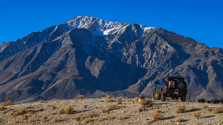
It was while the truck was perched on this small rise that I noticed a winged form laying still on the side of the road - a red-tailed or coopers hawk, I was sure. Calling to @mrs.turbodb, my heart sank when I saw it was a great horned owl. It must have been hit by a truck on the highway the night before, rigor-mortis only just staring to set in.

Even in death, striking.
Knowing that we didn't want to just leave it laying there in the open, I gathered some branches from nearby bushes and scooped up our tragic discovery, moving it away from the road and settling it into the shade of a tree, its head oriented toward the glorious mountains.
Despite the somewhat tempered mood, it was time to move one. Our first destination was a petroglyph site known as Rosetta Stone. There's a bit of hike to get there - and we weren't even sure where there was - but I'd tried to piece together the clues I'd found in my research, and as we meandered along one of the plateaus of the Tablelands, we spotted a cave that I knew meant we'd found the right spot!


Home, perhaps, for the artist?
Below the cave, in a thicket of brambles, the Rosetta Stone sat - as it has for centuries - waiting to be read. What it says, we have no idea, but the markings are similar to those elsewhere in the Tablelands - a collection of hands and some concentric circles with lines radiating out.
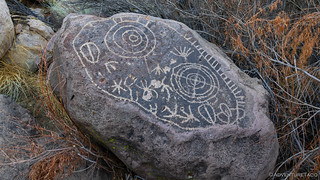
Rosetta Stone.
Our spirits lifted a bit after this success, we headed back to the Tacoma - a few miles between us and our next stop. To get there, we'd traverse the southern border of the Tablelands - along Chalk Bluff Road - to Highway 6, which runs up the eastern side, and then continue a little way into the White Mountains - to investigate a mine I'd spotted when researching the area.

Chalk Bluff Road is a heavily travelled gravel road, used by rock climbers to access Happy- and Sad Boulders, and as an access road for fishing. As such, it's as corrugated as Saline Valley Road in Death Valley, and we were glad to be aired down for this part of the journey.

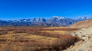
Halfway along the road, we ran into a grader - likely making a final pass before winter really set in. Boy, let me tell you how nice it is to run a trail immediately after it's been graded.

Smooth bliss.
Well, it turns out that the Southern Belle Mine - the place we'd hoped to visit - is no longer as accessible as satellite imagery may suggest. A small neighborhood has sprung up below it, the access roads becoming driveways as the land was developed. I'm sure we could have found a way through, but neither of us really wanted to push our luck - especially for something that was a bit "peripheral" to the trip in the first place, so we turned ourselves around and headed back across Highway 6. From here on out, we'd spend the rest of our time in the Tablelands!
Our first stop - along the eastern flank - was a prominent example of Bishop Tuff. Composed of the volcanic ash ejected from a vent during a volcanic eruption, the ash hot enough that it is lithified - by welding itself together as it cools - resulting in a relatively soft rock that when eroded, creates fantastic walls.


What do I spy peaking out above the Tablelands?
Near the sample of tuff, an old pumice mill stood tall, its conveyors, sifters, and hoppers used in mining the tuff until it became uneconomical to do so.


We climbed around for a bit, noting that unlike many of the historic gold mills that we see - where each level and implement seems significantly specialized - the pumice mill was a series of the same sifters and shakers on each level of the mill. Clearly, the vast majority of the operation was simply sorting the material into different sizes - mostly for use in the construction industry.

Anyhow, we didn't spend too long at the pumice mill - we both knew that what followed over the course of the next couple days was going to be way more interesting than sorting ash! And so, we headed back towards the southern end of the Tablelands - to the Fish Slough area - where after soaking in the views, we found a wonderful information sign that even had high quality, free, maps of the area!

The views - every time we looked west - were simply stupendous.

Views. As far as the eye can see.

I don't usually include informational signs in my write-ups. But this one led to tragedy!
Reading the sign, and pouring over the map, I set down my camera in order to show @mrs.turbodb where we were headed. To my surprise, not only were all the roads I'd carefully mapped out present, but several points of interest and hundreds of additional roads criss-crossed the landscape. With a couple days to just wander, finding this map at the beginning of our trip was a grand, unexpected discovery, and we both climbed back into the Tacoma with smiles on our faces as we set off for our second set of petroglyphs for the day.
Tooling along for almost a quarter mile, I told @mrs.turbodb that I was especially interested in this next petroglyph site because... and then, the Tacoma went thu-thump, stopping my story mid-sentence.
"Shit. Shit, shit, shit, shit, shit.
I just ran over the camera."
I mean, there wasn't really any question. I could see it bouncing - in more and more pieces with each tumble - in the road behind us. We stopped. I walked slowly back. Yep, it was... not good.

Sad day.
Nothing survived except the SD card and battery. My favorite lens and the body were quite clearly done for. Curious if it would still work - perhaps I could take the rest of the photos on the trip with my wide angle lens - I hopefully clicked the unbroken lens into place. Unfortunately, while the shutter worked, the exposure - and likely focus - was way off, requiring a -3EV setting just to get something that wasn't completely washed out.
Dang.
Deflated, we climbed back in the Tacoma and had a short discussion about what to do next. It seemed a waste to end the trip just because I ran over the camera - especially with such glorious conditions to explore. We could always come back - in fact, everywhere we visit seems to call us back anyway - so we carried on.
Fifteen minutes later, we arrived at the petroglyph site I'd been so excited to see - Kitchen Rock. This was where I thought I'd find an unusual volcanic "wave" that I'd seen in a photo from Eric @ETAV8R, and which had really kicked off the planning for this trip. I'd had essentially no luck finding any information on the location, except that photos of other locations in the Tablelands didn't seem to contain the "wave."
Alas, after looking around and admiring the few glyphs that we found at the site, we found no volcanic wave and headed back to the truck.

Art of Kitchen Rock.
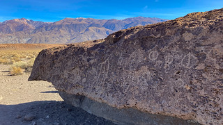
White Mountains rising in the distance.
Continuing up Fish Slough, the rest of our day would be spent exploring even more rock art - our next stop at the Chidago Canyon Petroglyphs. Much larger than the previous site - and with many more glyphs - we normally would have spent half an hour here.
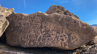
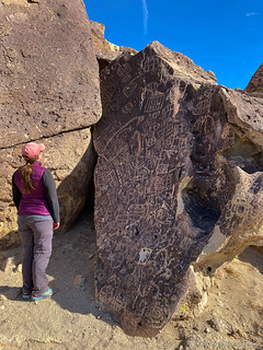

Today however, we probably only spent 10 minutes, for a couple reasons. First - of course, was the situation with the camera. Second, the fact that we hadn't found the wave - where I'd expected to find it - bothered me a bit. Obviously we couldn't do anything about the camera situation, but despite the necessary backtracking and unknown outcome, @mrs.turbodb kindly suggested that we should go back, if I wanted to look again.
So we did.
All I can say is that the wave is much smaller than I expected it to be. I'd walked right by it the first time, still distracted by running over the camera - but there it was, right out in the open, waiting to be found.
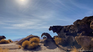
Finding the volcanic wave was the highlight of my day.
I was surprised to find myself both excited and disappointed, when my usual reaction to finding something I'm in search of is pure glee. It was then that I began to realize how truly enjoyable the act of taking photos has become for me over the last several years.
What a change from my first trip on The De-Tour, when I was new to all this truck-based exploration and proudly told my new acquaintances that, "My Google Pixel takes amazing photos, I don't know why I'd ever need to use a dSLR." It wasn't the last naïve thing I'd say to Mike @Digiratus, Monte @Blackdawg, and Ben @m3bassman, but it may have been the first.
Looking back now, I have no idea why they didn't give me a harder time. Maybe because I was the new guy.  Whatever the reason, thanks guys!
At any rate, having successfully found the wave, we set out again along the route we'd planned and soon found ourselves in a sea of boulders covered with glyphs. The Red Canyon site was even larger than Chidago Canyon, though the sheer number of petroglyphs was significantly smaller.


As we wandered around - this area covered several acres, with paths twisting every-which-way between the boulders - I was finally able to acknowledge that I wasn't really going to have enjoy this trip in the way that I'd hoped. I think @mrs.turbodb may have known that even before I did, because when I brought it up and suggested that we change our plans, she was completely open to the idea without any hesitation.
And so, it was at that point that we decided to head west. OK, we were heading west anyway as part of our Tableland exploration, but I mean farther west - all the way to the coast of California - to visit my parents. So often - at least during the winter - we find ourselves down closer to their neck of the woods, but don't have time to stop in. There really wasn't any better time to switch things up and brighten their day!
So that's where we headed. The good news was that to reach US-395 and head west, we had to traverse the Tablelands - giving us a bit more time to enjoy the sun and dirt as we drove through the narrow walls of Red Canyon.
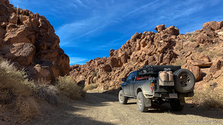
But soon enough we reached Benton Crossing Road and found ourselves putting air in our tires - several days before we'd expected, but knowing that in the end, we'd have plenty of opportunities to see more of this glorious place.

Not every trip can go exactly as planned, and I count myself lucky that so many have gone so well. Sure, a locked gate here, a detour there, and a crushed camera every now and then put a damper on things. But all-in-all, I can only consider myself lucky.
As we headed north on US-395 the weather couldn't have been nicer. Nary a gust of wind as we passed Mono Lake, it's surface glassier than I'd ever seen it.
We shall return!


Great read, thanks for sharing! Sorry to hear about your camera! I would come unglued if that happened to my new Canon R! And your right, my Google Pixel 4 takes great shots too! Looked like a fun trip! Happy Trails!
Bro, that was another awesome read. I felt your pain with your camera loss and that happened to me when I was living in Indonesia. I did have my camera equipment insured so I was covered. You still managed to take great photos
I just recently discovered your adventure blog and photos! I'm already addicted to your tales of discovery through my favorite places along Hwy 395. The owl and your camera.....truly tragic. I will wait patiently for your next adventure.
Hi Janet, Glad you found the site and I'm happy to hear that you're enjoying the stories! The trip to the Tablelands was a bit of a bummer, but life has its ups and downs, and I've been lucky enough to have mostly ups, including all the trips after this one! Thanks for the kind words, and I hope you continue to enjoy future adventures!
Hello, just discovered your site. Bad day for camera and owl. I have a 96 T100 4x4. What brand bed tent is that in the first pic? Also today I am using your most excellent how to on a transfer case replacement. Very good how to with most excellent pics!!!
Hi Eugene, glad you found the site, and that the transfer case replacement is useful for you! The tent you see on my truck is a CVT (Cascadia Vehicle Tents) Mt. Shasta, which I wrote about picking up and installing, here. It's been a great tent over the years, but I'd recommend reading a couple other posts about it as well:
Hope that helps, and by all means, let me know if you have questions. Also, if you wonder about anything else on the truck, you can check out all the details here: The Toyota Tacoma. Cheers! ?