
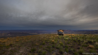
Out on the end of Owyhee's Tongue was one of the windiest nights I've ever spent in the tent. I think things calmed down for about two hours - between 10:00pm and midnight - but for the rest of the time, it was like sleeping in a washing machine. For how windy it was, I still slept relatively well - waking up now and then when the entire truck was rocked on its suspension, but always dozing back to sleep within a few minutes.

I woke up an hour before sunrise and snapped a cell phone photo before zipping up the tent again and sleeping for another 90 minutes!
Having known that clouds were scheduled to roll in after the previous beautiful blue day, I figured there wasn't really any point to being up for sunrise, so I hadn't even set my alarm. My hope for today was that the weather-guessers had gotten it right - clouds but no rain - and that there'd be enough contrast in the clouds to provide a little drama to the day's photos. Only time would tell, but the windy morning in camp - when I got my first real view off of The Tongue - seemed to get off to a good start!

Just a peek of sun for the day, streaming in under the clouds that would only grow thicker.
The rain fly was definitely getting a workout!
I decided that before having breakfast - I knew it would be "interesting" to try and pour/eat Cheerios in 40mph gusts - I'd do my best to get the tent put away. I've found that having the side of the tent oriented into the wind seems to result in the least wind noise at night - unintuitive to me, given that it presents a larger surface area - which meant that I didn't have to fight the wind to fold everything up, a small win that I was grateful for!
Fifteen minutes later, I was inadvertently distributing Cheerios across The Tongue as a gust of wind carried several of them over the edge of my bowl. Determined not to lose any more, I headed for the edge of the plateau, where I hoped to eat in peace. It was truly amazing how calm it was just below the rim - if only I'd been able to park here the evening before!

Looking south, the Owyhee River winding its way toward me.
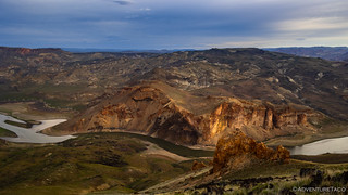
Directly across from the tip of The Tongue, colorful walls rose a couple hundred feet above the water.

To the south, Lake Owyhee. Just visible in the lower right, I completely missed the metal roof of a cabin I'd visit just a few hours later!
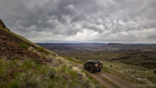
Breakfast consumed - and the wind driving me from my camp - I had three out-and-backs planned for the day, in addition to the and-back that I still had from The Tongue itself. And so, I set off on my first - a bit to the east - down into the canyon.

Dropping down off of the plateau, the landscape below me looked promising!

Soon, I was driving into the landscape I'd seen from above.
It was as I was making my descent - or rather, that I was out of the Tacoma photographing it - that I heard a roar overhead. "Strange," I thought, "it sounds like I'm in Death Valley." Sure that I'd look up to see a passenger plane, I was stunned to see a couple F-15s engaged in a simulated dog fight! Having only seen my first dog fight a few weeks earlier, I was pretty excited to see another one, so far away from the first.

America.
After watching the air show for as long as they remained in the sky above, I climbed back in the truck and continued on my way - my spirits high with the day off to a fabulous start.

Owyhee geology. I don't know what it is, but it's all volcanic.
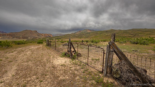
Before long, I found myself at a gate. This isn't all that uncommon in Owyhee - after all, the entire place is used by ranchers for grazing - and as I was opening it up to pass through, some names etched into a rock next to the gate caught my eye. I went over to investigate.

The names didn't turn out to be that interesting - likely fakes given the "1820" date, but I did really like this detailed elk; to my knowledge, not a local beast.
Wrapping up the out-and-back canyon, my next out-and-back wasn't far away. In fact, it was just on the opposite (west) side of The Tongue, and soon I was once again dropping off of the plateau into the valley below. I was headed into Blue Valley.Despite their proximity, the feel of the two canyons couldn't have been more different. While both were green with spring, Blue Valley had very little of the orange rock that I'd been immersed in all morning. Rather, rolling, folded hillsides stretched out as far as the eye could see - only broken by distant buttes and the meandering flow of the river below.
Down into Blue Valley, the clouds continued their dramatic contribution to the landscape.

Red Butte, looking a little green in the spring.
At the bottom of Blue Valley, the road forked. I'd be taking each fork - both out-and-backs as it were - before the day was done, but I decided that I'd head east, first, to the old Watson Cemetery and to some petroglyphs I hoped to find. It turned out that this section of trail was rather narrow and rocky - mostly designed for, and travelled by, ATVs. Having discovered the previous afternoon that I'd forgotten to reinstall my front skid plate - after a Shop Day at Zane's - I decided that it'd be prudent to hike the final mile, rather than risk a cracked oil pan.

Cross-country travel at its finest.

Look at those layers!
The Watson Cemetery still sports a reasonably fancy gate.

There were only six headstones in the entire place, two of which were blank. I wonder if others have been completely lost to time.

I was excited to find the petroglyphs I'd been after. Their style seemed to match others I've found in the Canyonlands, though I've never seen a rainbow here before!

There were quite a few petroglyphs at this site, but my favorite was this tree surrounded by dots.
Unlike my slow pace in my first canyon of the day, I kept up a reasonably quick pace in Blue Valley. There were a couple reasons for that, but the most important at this particular time was that I was getting hungry. There'd been a perfect lunch spot near the Watson Cemetery - and I could see my kitchen - but alas, it was a mile upstream.

If only I'd driven, I could have been enjoying lunch rather than hiking towards it.
The other reason I found myself speeding up a bit was that the clouds overhead seemed to be a little more... threatening than they had in the morning. I didn't feel any real worry - yet - of actual rain, but I did find myself wishing that I'd checked one of the ham radio weather stations for the forecast prior to dropping down out of broadcast range.
The Owyhee Canyonlands are no place to be when rain turns the roads to a mucky mess!
With only a mile to cover, I was back at the truck in no time, and headed west on the second fork of the Blue Valley route. Ultimately, this fork would take me to Hattie Harrell's Island Ranch, but first I had more draw-dropping scenery and lunch to enjoy.

The sky isn't looking great, but that mountain-of-volcanic ash sure is!

Winding my way along the river, wondering how long the rain will hold off.

When the sun poked through - for the last time it would turn out - I seized the opportunity and assembled lunch in a rather perfect location.

I've seen this arch before.
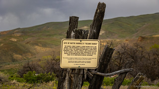
It was a little after 1:30pm when I spotted Hattie Harrell's ranch in the grove of cottonwoods ahead. We'd first seen this ranch from the other side of the river - almost exactly a year earlier - on our Owyhee West trip, and I'd wondered ever since, what it was.

Curiosity - nearly - satisfied.
It turns out that - like the Griffith Ranch a little further upstream on the west side of the river - the creation of the Owyhee Reservoir led to its demise. From a U.S. Bureau of Reclamation sign:
The Harrell family earned a living raising cattle and horses. Two waterwheels irrigated alfalfa hay grown on their fields. The farmstead contained a stone house, bunkhouse, shed, stables, corrals, and storage cellars. In 1927 Harrell's 139 acres were purchased by the U.S. Bureau of Reclamation for $3600 as a buffer for the soon-to-be-constructed Owyhee Reservoir.
Satisfaction.

The ranch house was built in two phases it seemed - likely with the wooden structure being added to the stone one - and connected by a hallway - as the family grew.

A ranchers home.

A nearby dugout looked quite appropriate under a dead cottonwood.
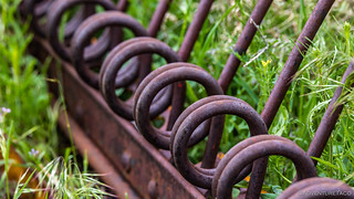
In the yard, an old thatching machine lay rusting under the gray sky.

One of two waterwheels that irrigated alfalfa hay grown in the Harrell family fields.
Well, with a bit of my curiosity satiated by visiting this homestead I'd been wondering about for more than a year, it was time to scratch another itch that had been bothering me for approximately the same amount of time. On that same trip - along the west side of the Owyhee River - I'd spotted a road high up on the eastern escarpment of the canyon. A series of switchbacks, I made a note to investigate when I got home.

I year earlier when I spotted this zigzag I thought, "Doesn't that look intriguing!"
Now, with a bit more knowledge, and a lot of history, I couldn't wait to investigate this trail. That is, assuming the rain held off!


More excellent photos and a fine adventure, makes me want to get out more! Thanks for sharing. Nice to see that so many places have been preserved. Down here so much history has disappeared because of desert vandals that just destroy things for no reason. Many of the places we visited and enjoyed 50 years ago are now non-existent.
Thanks John! I don't know that the Owhyee's are any more well-preserved than anywhere else. I feel like there are lots of things here that are destroyed as well, unfortunately. As with everywhere, there are always some hidden treasures that somehow squeak by without drawing attention and end up surviving.
In the case of Owyhee, the fact that much of the land is leased by the BLM to ranchers means that structures - old cabins, etc. - end up getting used as shelters by cows, and will meet their end sooner than later for that reason.
I can only imagine what was available to explore 50 years ago. Heck, a bunch of the cabins might have still been part of active homesteads/ranches not too much before that!
Glad you enjoyed as always! Love hearing when you do.
Hi ! I enjoy your adventures very much. I happen to drive a 2000 Tacoma too; only mods air shocks and bigger tires. I live in Mimbres, NM and really liked your trip through Chloride Creek and beyond; I have been there many times. Sadly all that area is burning or in danger from the terrible Black Fire, now tied for the largest in New Mexico history.
I love your photos. One question: The big black and white landscapes that frame your color shots are so intriguing, but I can't figure out how to see the whole thing and freeze it on the screen!???
Thanks for a very informative and beautiful experience!
Pete Crum, Mimbres, NM
Hi Peter - glad you are enjoying the adventures and photos - it's always nice to hear! I've been monitoring the NM fires this year - partly because we were there last year and partly because I worry about them being an indicator for the rest of the west, which has had a tough run of it over the last 5-7 years already. ? It's tough - wanting to fight the fires in order to save all of the landscape that gets changed forever, balanced with the knowledge that periodic fires are good for the forests - probably something we should allow more often than we do (and if we did, they might be less severe when they do happen. As with the rest of life, hard trade-offs.
Very cool to hear you have a 2000 Tacoma as well. The air shocks were one of my first mods as well, so I totally understand - they add a lot of flexible functionality. And of course, bigger tires do too - both in the looks and off-pavement departments.
For the background photo on the site - that's a picture I took on one of my first big "adventure" trips. It happens to be down near Moab on Dome Plateau. Here's a link to the story with the original (color) version, and here's a direct link to the black and white version I made for the site background.
Fantastically beautiful scenery and images! Your image of Owyhee Lake with the tiny cabin roof in the distance is stunning!
Thanks Kim! I didn't even realize the cabin was in there when I took the photo, but I couldn't agree more on the beauty of that lake. Especially in the spring when the hills are so green!
Another great story and photos! Brought back many memories of riding the area on my ATV. Looking over 'Blue Canyon from the top is an awe-inspiring view that is hard to take it all in, the expanse of the view and the colors are breathtaking.
The newer Mackenzie place looks like they have done a lot of work on it compared to when I was there last time. The old cabin is used often when moving cows. Did you notice the runway and windsock?
The Tuff rocks are so colorful and jagged that this is another view that is hard to consume in one visit. Hattie Harrolds is quite the place and very modern in its time. Good thing you didn't take the trail along the river at Watson's as it is very difficult even on an ATV around the hot springs.
The old cabins fair pretty well until the roof caves in and then it is all downhill and the rats and mice take over and set up residence. Be careful not to disturb the dropping piles as they can be very dangerous to your health.
It is not uncommon to see elk in this area, majestic creatures. Fortunately for you did not encounter rain, as the ground turns to Owyhee Gumbo, it can build up on your undercarriage and become a major problem besides being extremely hard to remove even with a pressure washer.
Your photos are breathtaking!
Thanks Dan we all appreciate your travels very much.
Always good to hear from you Kenny - especially on the Owyhee trips! When I reached out to you before leaving for this trip about the gate status on Blue Canyon, I think what you told me was "Blue valley road is a spectacular view from the top, it is rough and rocky going downhill but passable with caution." It was a great description, and when I looked down into the canyon for the first time - from The Tongue when I woke up in the morning - I knew I was in for a treat, and immediately understood the emotions I could feel in your email. It reall is awe-inspiring.
I didn't notice any windsock or runway at the Mackenzie place, but the grass was long, and I'm sure the road hadn't been passable (snow) for very long before I made the trip down. Both cabins down there look like they are in great shape.
The Hattie Harrold ranch is on its last legs. As you've alluded to, the roof has gone in several places, and the ceilings have already (mostly) collapsed. It'll just be a matter of time now before the structures are finally reclaimed by nature. A little sad, given that they've survived for nearly 100 years since they were acquired by the Bureau of Reclamation, but just part of life I suppose.
And boy, do I know about the Gumbo. That's what had me worried. Here, and in the next segment of the trip! ? But hey, now I'm getting ahead of myself.
For anyone reading through the comments here, Kenny was nice enough to share with me, several photos that he's taken in this area of Owyhee in many decades of his travels in the area. He is - I believe - one of the foremost experts on this special place that spans Oregon, Idaho, and Nevada, and I'm so grateful for the information he's shared with me over the years. Thanks Kenny!
Click here to see the photos: Owyhee's Spring Creek, 2014.
Dan,
The video came out fine! I enjoyed watched the wind move the grass in green waves...
Also intrigued by the cabins. Thank you for cleaning up a bit.
Another nice adventure.... Waiting for more!
Thank you!
David
Thanks David! I wish I'd gotten a bit more wind blowing through the grass, but hopefully the point came across anyway, hahaha! The cabins were great - always a treat to come across structures that are clearly still cared for when I'm out on an adventure. Helps to underscore that there are other people who enjoy these places enough to continue to invest in them, so I'm happy to help out with a bit of cleanup. ? Next part of the trip coming in a day or two (I hope).
Another excellent selection of photographs illustrating your travels! Your transition to the Canon mirrorless system has not reduced apparent image quality. Question: have you changed the Canon defaults for image quality, saturation or other variable?
I'm not sure but I think that machine was a thresher not a "thrasher".
Hi Anthony, glad you enjoyed the story and the photos, it’s fun putting them together but is also a lot of work, so it’s nice to hear when others appreciate the results!
From a quality perspective, I really like the mirrorless canon R6, the sensor in it is fabulous, and the RF lenses are significantly higher quality than the EF-S glass that I was using previously.
I shoot all of the photos in raw format, so there is definitely processing of each one after I download them to my computer. I outlined that process in a post I wrote a couple years ago when I was still using my DSLR, and buy a large that workflow has not changed. As such, I do change the sliders that affect saturation and exposure and highlights and shadows, etc. but only to get the photo to represent what I feel like I saw when I took it.
Anyway, hope that answers your question, and by all means let me know if you have more.
I drove down Blue Canyon Road in 2004. There are a couple of ruins down there. One is above the high water line, a old homestead and some dug outs. The other is visible when the water level is lower. Turns out that it was the old Watson Post Office. Looks to me by your pictures that you must have drove right past that one. I passed it hiking into the Watson Cemetery. At that time the lake was right at the old cut stones and it stuck out pretty good. Probably surrounded by high grass at this point though. Hit me up if your going down in there again. I think I can trust you with some coords. George.
Is the Harrell Place (pictured in this story) not the one that's above the water line down there in Blue Canyon, or are you thinking of a different place? As for the post office - my understanding was that it was on the other (north at this point) side of the river, but I've never visited it, so I could have walked right by as you suggest! More reasons to go back - never a bad thing!
I have not been to the Harrell Ranch yet. I tried a few years ago, but nearly slid down a gully when the road gave away under my rear passenger tire. Pretty much was a showstopper at that point.
The place I referring to is about where the slack water of the full reservoir is. I don't think it would ever be under water though. Foundation and some dug outs in the hillside are there. It is not marked on any maps I have. I just stumbled upon them since that is where the road ended and I was doing a bit of hiking. Also, spooked up a huge Buck on the ridge right above the dugouts. 2nd bigest buck I have seen.
The Post Office was on a ranch from my understanding. I used to have a map made by the original Watson residents at a reunion back in the 60's but it got lost when my hard drive crashed. There are some nicly carved stone blocks there. Probably a good thing they underwater or don't stand out too much in the weeds, otherwise they probably would not be there anymore.
There wasn’t any no trespassing signs? Look at the picture of the newer cabin in spring. There is a no trespassing sign in the window of the door. Along with a surveillance camera that is not seen in the picture.
Hey Lawsen, I'm not sure what you're getting at here... I don't think I said there were "no trespassing signs," rather, I said that there were signs:
...and as such, I only took a photo through the window, rather than going in to investigate. If I did suggest that there weren't trespassing signs somewhere, please let me know where, so that I can update the story.
Who did you get permission from to get in spring?
As I mentioned in the story, like much of the rest of the Owyhee area, there were no locked gates and no "no trespassing" signs on my route in, so I was just exploring. In fact, I mentioned in the story that I'd heard of a locked gate at the bottom of the canyon, where I did in fact run into one (with no signage). I assumed - again - mentioned in the story, that it was to keep boaters from heading up into the canyon.
I'm curious if this is your place/cabin, or what your relationship to the area is, as you seem quite protective. I'm pretty careful about how I explore, and I like to be respectful of what I find, so rather than insinuate, it'd be great if you could be a bit more forthcoming with your concerns.
I have been around that area before and is all private down in there. How did you get permission to be in there and from who? You obviously knew it was private from what your buddy told you and when you drove around the gates with locks going in there. That clearly shows you were trespassing. It’s fine if you want to make blogs about places but don’t trespass in the process.
Hey Spencer, As I noted in the last comment - and in the story - there were no locked gates that I drove through, and there was only one locked (but unsigned) gate at the end of the road near the lake, which I assumed was to keep people down at the lake, rather than away from the lake. As for being private land - some of it was. With the exploration I do, I am constantly traversing both public and private land, and I've found - from speaking to ranchers, land owners, etc., which is something I do as often as I can since it's a great way to learn more about a place - that they are generally OK with respectful travel along their roads as part of that exploration. In fact, while out exploring Owyhee, I had a great lunch with a rancher (and his wife and son) who even suggested a few more places to investigate, and invited me to drop by for dinner if I was so inclined. Ranchers who prefer that folks not travel on their land tend to lock and sign gates, and this is something I always respect - like when we were working our way over the southern end of Steens Mountain and ran into a locked gate for the Roaring Springs Ranch.
As for my buddy - he's been all over the Owyhee for the last 70+ years, placing many of the water tanks, working with ranchers, and even living in Arock for a time (his wife is from Arock). He's shared photos and stories with me of his time in the area, including many in these parts. As someone who follows the rules and knows the area, I'm certain that he'd have mentioned to me if he felt that anything was out of bounds.
Anyway, all that doesn't meant that I don't make any mistakes, and as I mentioned to Lawsen - if this is your place/cabin, and you'd prefer that folks not be there, I'm happy to update the story to note that. I would like a little more background though, as it seemed like pretty "normal" Owyhee exploration to me.
It’s my family’s place. People are not allowed to be exploring in there. It would be in your best interest to take the post down.
You may not have noticed, but I'd already removed that portion of the story while I investigate further via several contacts I have for the area. Hope you are enjoying your new year!
Last May was my first time to the Owyhee's. The second we got off the pavement I quickly realized I did not allot myself enough time for all the areas I wanted to explore. As I'm sitting here planning my next trip, i stumbled onto you blog. Thanks for sharing and your pics do a great job capturing the beauty and mystery about the Owyhees! Cheers
Awesome, glad you found my stories and photos PJ! I'm curious - how long were you in the Owyhees last year and where did you go? How long are you headed for on your next trip, and what's on your list so far?