
Having drifted off to sleep to the pleasant pitter-patter of rain, it was extra nice to wake up just before sunrise to clear skies and a completely dry tent. Letting @mrs.turbodb bank a few more minutes of shut-eye, I headed to a nearby ridge to watch the sun crest the horizon.


Half an hour later, my whistle - carried across the sandy slopes on a cool breeze - was answered in kind as @mrs.turbodb started her morning routine while I retraced my steps back to camp and broke down the tent.
With a full day of activities ahead, we held off on breakfast - opting to make our way east - to Kelbaker Road - and then south - to Granite Pass - before indulging in our morning bowl of Honey Bunches of Oats (with Almonds) and setting off our first seven-mile trek of the trip!
This was a hike that I thought - unlike the vast majority of hikes I plan - would simply be a nice, leisurely stroll through some wonderful landscape. There was no mine or petroglyph to be seen at the end, and the route wouldn't wind its way through a dramatic canyon on the way to a commanding overlook atop the highest peak.
Rather, I hoped that we'd find - in the southern reaches of the Providence Mountains - a leisurely abandoned road offering a gentle path to explore this isolated region on foot. Climbing alongside beautiful outcroppings of artfully weathered monzogranite boulders, it would afford us the opportunity to enjoy wandering through a wonderland of rocks before descending to a loop through Quail Spring Basin - a desolate high-desert valley carpeted with extensive cactus and yucca gardens - before returning the way we'd come.
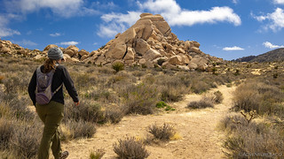


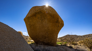
The most interesting boulders were a short distance from the trail, and the hillsides - sprinkled with piles of smooth jointed rocks that hold narrow passages and cool caves, slickrock, inviting coves and occasional small arches - called to us for a closer look. We obliged, joyously, as we continued towards the apex of the route.


Even with our off-trail scrambling, we made good time to the loop around Quali Spring Basin. Here - as with the first couple miles of the hike - the attractions - more artsy rock - were easily just off the main trail, our path wandering this way and that as each new sight caught our eye.


It was only a bit after 10:30am when we arrived back at the truck and headed north for a quick stop at Kelso Station. Built in 1923 by Union Pacific to compete with the Harvey House stations on the Santa Fe line, the depot was a spacious two-story building with a waiting room, a ticket office, a telegraph office, a baggage room, living quarters for staff, a billiard room, and a library. A 24-hour eatery would be added later. Closed by Union Pacific in 1985, it was acquired - for the sum total of $1 - by the National Park Service when Mojave National Preserve was created in 1994. Over the next several years, it was renovated and since 2005 has been the preserve's main visitor center.


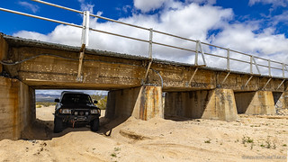
From Kelso Station we turned northeast for a short stint on Cima Road. Luckily it was open, a month-long closure for resurfacing scheduled to begin only a few days later. Our destination - Macedonia Canyon - was only a few short miles up the road and soon we were out of the truck watching as a Union Pacific train barreled over the wash that doubled as our route.


Having never driven Macedonia Canyon before, I'd initially mapped it as a way to quickly cross the Providence Mountains, but upon further research - of the satellite variety - I discovered a couple of mines off of the main route and we decided to check them out. At the very least, we figured that they would be a great place to enjoy a lunch that we'd both been looking forward to since picking up the key ingredient at In-N-Out Burger when we'd arrived in Las Vegas.


It turned out that we we'd parked at the Blue Rock Mine. Originally the Confidence Copper Mine, only small shipments of ore were made in 1918. In the 1980s, Bill Brown - who lived in Los Angeles and drove out to his mine on weekends - bought the property. Bill mined the Blue Rock for "pods" of scheelite (tungsten ore) even though there was still substantial copper mineralization on the property. By 1998 the mine was no longer active, the roof having been torn off of the cabin, and Bill's "jeep" and trailer - which he stored at the Cima Store - abandoned.


After a tasty lunch and a bit more exploring - there was an old, collapsed cabin constructed of railroad ties not too far away - we hopped back in the Tacoma and headed a little further up the canyon to a second mine I'd discovered. While we hadn't seen much at the Blue Rock, I hoped this one would have a bit more in the way of artifacts - at least, it appeared so from orbit.

The Columbia Mine lies at the head of a valley that drains northwest from the north end of the Providence Mountains. The workings include a shaft 380 feet deep which is inclined 49°, from which there are drifts southwest at 100, 200, and 300 feet. Primarily in search of gold and silver, these drifts explore the footwall vein. A crosscut from the south side of the ridge and a connected drift explore the hanging-wall vein. A crosscut from this drift meets the shaft at the 100 foot level. Water stands in the shaft 120 feet below the surface.
The records of the early production, when the shaft was sunk and the levels run on the footwall vein, are not at available, though between 1900-1905 there was a 5-stamp mill on the property. During recent years, 57 tons of the highest grade ore that was shipped containing 0.28 ounce of gold and 35 ounces of silver per ton.Tom Schweich


(It's a homemade wind mill... on its side.)


By the time we were done at the Columbia Mine, we'd spent quite a bit longer in Macedonia Canyon than I'd initially expected we would. This wasn't a problem. In fact, I viewed it as a solution to a dilemma I had about where to camp for the evening. Had we blown through Macedonia in only an hour or so, our arrival at camp would have been quite a bit earlier than usual. However, with progress rivaling that of a Mojave tortoise - which I'm not sure even exist despite the thousands of empty burrows I've seen - we'd arrive at our next destination a couple hours before sunset - perfect to do a bit of exploring and then find camp!
Dumb luck strikes again.
Back in the Tacoma, we made quick work of the rest of Macedonia Canyon - the sun and wind at our back; the road mostly smooth - on our way to Council Rocks and a nearby cave. We stopped only a few times to snap a quick shot here and there, @mrs.turbodb taking advantage of a warm cab and fully belly for her afternoon nap.
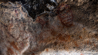
Note: the location of this cave and the nearby rock art is not well known, so if you know - or discover - where it is, please don't mention the name or location, especially on the internet. Do your part to keep this special location from becoming vandalized.


It's easy to see why this area was used by early Native Americans. Not only is it sheltered, but two water sources - a small tank in the drainage and a spring - exist nearby, affording anyone who found it a better chance to survive in this hot climate for an extended period of time. A ceiling covered with pictographs and floor covered with grinding holes bear witness to those - likely Chemehuevi or Mojave, if not the Desert Archaic before them - who found this place hundreds of years ago.


In addition to the cave, a nearby field of large boulders was scattered along the base of the mesa. Even before finding the cave, we'd discovered a few petroglyphs carved into their hollows, and so we headed back for a more thorough search as the sun raced towards the horizon.


As we were ducking in, out, under, and around every nook and cranny that we could find, I made my way to the base of the mesa, wondering if some of the overhangs might have provided shelter to the Native American Indians who once called this place home. While I didn't find anything I recognized as human - though, that doesn't mean there wasn't something to find - I did discover something I've never seen before!


I was pretty jazzed to have seen the hive, but with only a few minutes until sundown, I was reminded that it's easier to take care of dinner while it's still light out. And so, after a day of leisurely exploration, we headed back to the truck to find camp and get ourselves situated for the night.


Our bellies satisfied and truck oriented head on into the 15mph winds, we hung out in the cab for an hour or so as I transferred photos and filled my copilot in on the plan for the following day. It was simple, really - only one hike planned for the entire duration - if one can ever call an 11-mile hike to the highest concentration of petroglyphs in the entirety of the Mojave Preserve simple!
For now though, it was time for earplugs as the wind, rain - and ultimately snow - fought to keep us from a good nights sleep.


Lots of that area looked to be cairns left by the giants of long ago. Great to see!!
Dan, if you haven't yet, pick up DStretch app for your phone, it will help reveal faded pictographs, used all the time by rock art researchers and photogs..
Thanks Eric! I've heard of DStretch, but always hesitated to fork over the money for it, since all the versions are paid (as far as I can tell). Someone mentioned iStretch to me earlier today though, which I thought I might check out (I'd not heard of it, and I have no idea if it's paid as well).
I joked around about iStretch (and DStretch) that for now, I just make do with whatever (little) my aging eyes can pick up on thier own, hahaha! ?
Thank you for sharing... your adventure is mine, now! The way you write makes it seem like I'm THERE-it is almost palpable!
You are welcome Kristin, so glad to hear you enjoyed the story! Always puts a smile on my face when folks do enjoy, and even moreso when I hear about it in comments! Hope you have a chance to look around at a few more trips - and enjoy them as well!
Cheers, Dan
I've been planning to visit that area but Kelbaker Road was washed out several times with our recent heavy rains here in the desert but I understand that the roads are once again cleared and open so plan to get over there before the summer heat sets in. Thanks for sharing another fine adventure. It's an interesting area, we have explored Afton Cyn where the Mojave River rises above ground and then goes back underground.
Definitely a good time to get out there before it's too hot. I think - just so you're aware - that there are still a couple closed roads in the area. Cima road (north of Kelso Station) is closed for repaving, and Black Canyon Road north of the Hole-in-the-Wall campground is closed due to a washout.
Always a pile of fun when the shovel comes off the truck.
Nice to see some road building going on.
Neat finding that abandoned hive, expect the cold got to them being that exposed.
I hadn't thought about the cold being the thing that did them in, what with it being in the Mojave, but of course, you're right as to the temps there (that even we were experiencing on this trip), and that would definitely be a reason to find something a bit more sheltered.
Such a big hive, I wonder how long it took to construct.