
It's been a busy month. I'd been home for less than 48 hours in the last 3 weeks, our trips to the Nevada BDR, a special place in California, and a family vacation to an amazing little place on the Sacramento River in Castella, CA. keeping me on the move. But, when Mike @Digiratus reached out to see if I wanted to go camping for a week - along with Dan @drr and Zane @Speedytech7 - I found it impossible to say no. So, less than 24 hours after returning home, I was linked up with Dan and the road again - headed east towards Idaho's panhandle.
Oh, and my A/C wasn't working, so lucky me got to drive with the windows down the entire way, the heat still sweltering as we crossed the desert.


We met up with Mike and Zane in Metaline, WA sometime around 5:00pm - they'd already been on the road for a night, and had a little bit of excitement as they relayed to us when we got out to say hello.
Apparently, Mike's (new) alternator had acted up - and failed - and he and Zane had replaced it with his spare in 90+ºF heat - not a fun prospect by any stretch, and I know Mike was happy to have had Zane around for the help! With that drama - plus the fact that Dan and I had driven all day - we were all ready to find camp, so as soon as we hit dirt on NF-22, we started looking for offshoots.
To shorten the search, we split up - Mike and Zane taking one prospect and Dan and I taking the other. This is a really nice side effect of Mike and I having Ham radios - we can communicate over longer distances than the CBs that we usually use on the trail would otherwise allow. I must say, the Kenwood D710G radio has never let me down in this regard, and with it I made quick work of alerting Mike to the site Dan and I had found - complete with a pile of firewood and lots of new smells for Dan's dog Echo to explore!

Not only that, but with my APRS beaconing, Mike was able to hone in on our location and reasonably quickly he and Zane pulled into camp.


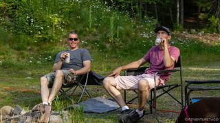
It couldn't have been much after 6:30pm when everyone was setup and we were all seated around the fire ring. Dan got a fire going, and Mike broke out his famous salsa - perhaps the best ever - as we shared stories and discussed any number of topics as the sun went down. At some point, dinner was made - everyone cooking over the fire - without losing a beat.
With plenty of wood, we sat around the fire for five hours before calling it a night - actually, I think I called it a night and the rest of the guys stayed up even longer. It was a nice end to a long day.
The Following Day
Our morning routine wasn't rushed - though Mike was up earlier than I've ever seen him - and we pulled out of camp somewhere around 9:00am. Our goal for the day was "simple" - head east into Idaho, and then follow the northern-most road along the Canadian border until it dove back down to somewhere near Bonners Ferry, ID. Then, we'd shoot north again, crossing over into Montana near Canuck Peak - which you can imagine is somewhere towards our friendly neighbors to the north.
But, plans are made to be changed, as we'd soon discover!
For the time being, we were cruising along enjoying ourselves - even if tree tunnels meant that the views were a little rarer than we'd have liked.


My A/C situation meant that I assumed the role of tail-gunner (the last truck) for nearly the entire trip, that position - and my Ham radio - allowing me to hang back to avoid the majority of the dust. And - a nice side effect - stop whenever I wanted to take photos. Aww, shucks.


We got our first little sense of foreboding when we turned onto NF-1013 - a road sign alerting us that the road was closed some 24 miles ahead, and only local traffic was allowed. Now, the sign looked quite old and worn, so we crossed our fingers that it simply hadn't been removed and the road was open. Plus, I noted over the CB that, "I am currently local to the area, and four of us make traffic, so I think we're good."  We had about 60 miles of road mapped out.
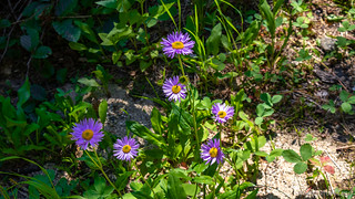
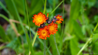
Well, about 12 of the 24 miles behind us, we passed a USFS employee travelling the opposite direction and a quick conversation confirmed for us that the road was in fact closed. And it had been for 30 years - that's why the signage looked so old. But, "You can get to the top, and there's a nice little waterfall," the woman told us, so we continued on - enjoying the views as they presented themselves, along with the spring wildflowers.


Soon enough though, Mike called out over the CB that we'd reached our first dead end, and when I showed up a few minutes later, he was already pouring over a Benchmark Atlas of Idaho, trying to figure out a new route.

While he did that, the rest of us poked around - Dan letting Echo run, Zane wandering off somewhere with a bucket, and I tried to find a bit of shade. It didn't take long to realize that we had to backtrack the entire way we'd come and then some, a risk with any trip, and just part of the adventure. First though, we all wanted to check out the waterfall, so we headed along the old road bed a few hundred more feet where we could hear it cascading down the hillside.


At the same time, we also found the official, "You aren't going past this point no matter what." end of the road.

It was cool here, and spring was still evident all around us - the greens and purples shining bright in the morning sun.

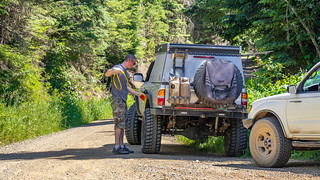
Now - something I've failed to mention up to this point is that - when we arrived at the dead end in the road, there was already a black 1st gen Tacoma parked in the turnaround area. It's owner was nowhere to be found - likely out hiking the wilderness and having a great time - but as one does when coming on another 1st gen, we all spent a few minutes looking things over.
This one was just fine with us!

Our curiosity satisfied and piqued at the same time, we climbed up into our own Tacomas and pointed them back the way we'd come - our route now taking us far to the south instead of way to the north.

Again, I took advantage of my position at the back of the pack to soak in the views a bit more than the other guys had a chance to do.

Our route ended up taking us down and along the east side of Priest Lake where we stopped in the little bit of shade we could find in order to have a bite to eat. The road here was paved, and of course - we all know that no true overlander takes photos on paved roads - our trucks only see dirt. Actually, I think I was just distracted by my stomach and forgot to grab the camera. You'll have to take my word for it - and this photo from Wikipedia - it was beautiful, as was some of the farmland around it.


Rather than stay entirely on pavement to Sandpoint, Dan found us a nice little shortcut with a bit of dirt. The only issue was that he was already running low on fuel, so a few minutes with a siphon and he solved that problem.
And - I don't have any idea how - but at that same time, it became Mike's "birthday." Mike, unfortunately, never noticed. Probably because we didn't get him a cake.

He did keep a close eye on us though, his Spidey sense knew that something was going on.
All fueled up, we were back on the road and headed east on Baldy Mountain Road, temps now in the 90°F's again, the back of my arms glistening with sweat as I held back to stay out of the dust.

None of the roads on this trip would be anything approaching technical, but what they lacked in difficulty, a few of them made up for in beauty. This road was one of them, and I took full advantage.


We arrived in the outskirts of Sandpoint a little few minutes before 4:00pm. As the guys had rolled along, I heard chatter of an advertisement along the side of the road. Something along the lines of, "I wish I'd gotten a picture of that to put on Mike's lawn." Begin a few minutes behind everyone else, it was no problem for me to stop and snap a quick shot.

Now, as ridiculous as this sign was - and as much as it would irk a reasonable man like Mike to find it in his front yard - the more I looked at it, the funnier it was. I mean, how can you not smile when you realize that the person who created this sign was the parent of a high schooler in town, and just couldn't resist adding a "Go Badgers" clipart to such a goofy sign? Priceless.
We all filled up with fuel in Sandpoint before turning our trucks north again and making our way to the highway for another long trek on pavement to Bonners Ferry, US-2 and US-95 following the same route through this stretch of Idaho.

Though @mrs.turbodb and I had visited Bonners Ferry as part of the Idaho Backcountry Discovery Route the previous summer, I didn't remember it at all, a clear sign that I'm getting too old for my own good. We passed through town quickly and soon we were winding our way along the last of the pavement before we'd hit dirt again to finish off the day.

We'd covered a lot of ground - more than 180 miles - by the time we found camp along Deer Creek - at 5:45pm. We were all ready to be done, the entire day having essentially been a re-route - and primarily on pavement, no less.

And this is the point in the story where I feel like it's important to make sure that the following is clear:
Re-routes are part of the adventure.
Figuring out cool places to see, off of the beaten path is hard. Sometimes it's impossible. People ask me all the time how I avoid running into locked gates and roads that "no longer exist." The simple answer is that I don't. Even the best route planners, with all the power of the internet at their finger tips - can't know that a road is gated, or that a washout has occurred since the last imagery update. Being OK with the fact that things won't go to plan and knowing how to recover - these are some of the most important attributes of any explorer.
So, as we sat in camp, I'm sure we mentioned how the day didn't go as planned - but it wasn't in a "the world is ending" sort of way. In fact, I'm sure we mentioned it only in passing, all of us happy to be outdoors and enjoying a little down time, out from behind the steering wheel.


Dinners were again all cooked on the fire - and we stayed up even later than we had the night before. It was tomorrow before we finally called it a night and made our way to our circle of tents. As we went to sleep, I'm sure we were all looking forward to the rest of the route - whether or not it was filled with Dead Ends and Road Closed signs.
After all, we'd find out one way or the other in a few short hours...


I find the “goofy sign” comment rather amusing as the tyrant is that currently infesting the White House and his BLM (you choose) is in the process of closing roads in southern Idaho that my family has traveled on for over 100 years and no doubt some that you have traveled on and written about in your blog.
Hey Mike, I wasn't really trying to make a political comment here, though I think the term "tyrant" doesn't fit the current president (Biden) - who has recently said he will voluntarily relinquish the presidency and step down when his first term concludes. Ironically, it probably does fit Trump who has made a series of comments implying that he would infact be a tyrant for at least some amount of time.
As far as why I thought the sign was "goofy" - I figured that it would be obvious, and I even tried to explain it a bit in the story, but I'll do it again - more explicitly - here for you:
As far as road closures go, the only people we have to blame for those closures are ourselves, the general American public. While it's only a small percentage of people who are idiots when out and about - shooting up historical artifacts, leaving trash and poop scattered across the land, and driving UTVs off-trail - those actions end up ruining it for the rest of us. I've picked up hundreds of pounds of shell casings, thousands of pounds of trash, and witnessed countless tire tracks in wilderness areas. If we as a people were better at respecting our public lands - leaving them as nice as we found them for the next guy - there'd be no need to close them. Rather, there's a sense of entitlement today - that "This is my public land, so I should be able to do whatever I want to it," that is despicable. It's simply not a political issue.
Additionally, nearly all closures by any public agency - be it the Bureau of Land Management (BLM) or USFS or NPS - are opened up to the public for a comment period before going into effect. I've participated in these comment periods, sharing my experiences on the land and supporting the organizations that work to keep access open, and I've seen many dozens of cases where that commentary affects the plan, often leaving some or all of the roads open. And yet, there are some closures and limitations that I agree with. The camping permit system at Alabama Hills is a good example. That location was overrun with people hoping to stoke their social media profiles, and there was so much poop and trash scattered about that it literally stank. If we can't do it responsibly ourselves, some management of public lands needs to happen.
Anyway, hope you enjoyed the story, and appreciate you leaving a comment!