
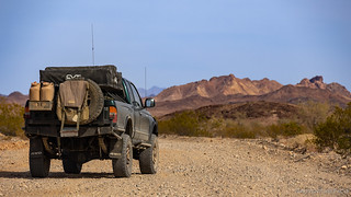
It was a little after 2:15pm when I veered away from the first stage of the Bradshaw Trail that follows Salt Creek Wash and across the Chuckwalla Bench. This is where Bradshaw's Trail first ventured into unknown territory. Previous expeditions having carried on to the northeast - through the pass that divides the Orocopia and Chuckwalla Mountains before following the north face of the Chuckwallas eastward to the Colorado River. By leaving the wash, Bradshaw saved roughly 200 miles of travel - surely one of the reasons that his route to La Paz became a popular one!

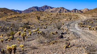
Onto the Chuckwalla Bench.
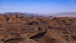
The views here were immediately expansive. To the north, the Chuckwalla Mountains rose up in the near distance and to the south, the Chocolate Mountains did the same - though a bit further away.

Layers of mountains extending into the distance.

A flowering ocotillo, windswept into a graceful arc.
As usual, it wasn't long before I found a reason to stop. A concrete foundation a hundred feet from the road caught my eye, and I headed over to investigate.
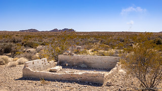
Riddled with bullet holes - which always makes me question the humanity that does such a thing - this foundation once supported an old gold mill where nearby miners could process their ore.
Those with keener eyes than mine may notice a plume of smoke rising in the distance behind the foundation of the mill. It was only after I had spent several minutes wandering around for different angles and was on my way back to the Tacoma that my attention turned to the south - and then, only because of the echoing boom that rumbled across the desert.

Well then, a good reason to stay off the Chocolate Mountains Aerial Gunnery Range!
Now aware of the active shelling, I would see plumes of dust, and feel the accompanying booms for much of the remainder of my journey. This was a new experience for me - the military activity I've seen in other places across the west always limited to in-air maneuvers - and was an exciting addition to my arsenal as I continued along the trail towards my next short detour.
One of the biggest struggles on a route like this was finding water; wells were prized and cataloged for further travelers. About a mile off the main route, the Gulliday Well was one such location - though as I headed north, I was pretty certain that there wouldn't be any indication of it having ever existed.

The location of the Gulliday Well is - today - decorated only by an old climate control vent that was dumped in the desert many years after the last wagon train.


A "standard" jumping cholla (Cylindropuntia fulgida) on the left, and a cute-and-cuddly-as-a-teddy-bear Munz cholla (Cylindropuntia bigelovii) on the right.
Trust me, after mistakenly picking one up, the teddy bear (Munz) cholla balls are not cute-and-cuddly-as-a-teddy-bear. Not even a little bit.
Having struck out again on anything historic at the well, I continued east. In my route planning, I'd noticed what looked by a cabin not far off the main route, and figured that I'd take a look. The road to it was completely gone, but with it only being a quarter mile off the road, I set off on foot to see what I could see. Which given my luck so far, would be nothing, probably.

On the way to the cabin, I noticed this interesting road grading technique.
"Well, at least it's not 'nothing'."
-me, trying to keep a positive attitude.
The graffiti on the door of this nearby vehicle about summed up how I was feeling about the washboard and historical sites on this trip.
A slow learner, I had one more trip up into the Chuckwalla Mountains before the major side-loop for this section of the Bradshaw Trail. Again, as had been the case with the previous forays, this one was to an old mine site that I'd spotted via satellite, a bit of detritus on the ground giving me hope that there'd be something interesting to see.
On my way to the unnamed mine workings, a small cholla forest.
As luck would have it, while I was photographing the cholla, a low thump-thump-thump caught my attention in the distance. I'd surely have missed them if I'd been in the truck - with the combination of air conditioning, sound deadening, and the bumpy road - but as I looked up to the horizon, a pair of planes I'd never seen before pounded across the Chuckwalla Mountains!

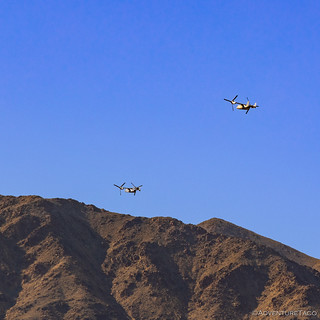
It's a chopper. It's a plane. It's a pair of V-22 Osprey!
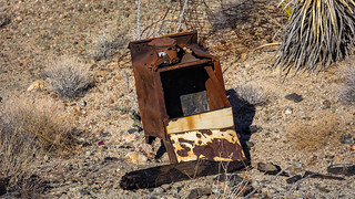
After seeing the planes, I traversed the last few miles to the mine site and photographed the entirety of the remains. This stove.

Found a survey marker on the way back.
With the time nearing 5:00pm at this point, I found myself thankful for what were becoming longer days as winter gave way to spring. Just a few short months earlier, sunset in Death Valley had been 4:30pm - so I counted myself lucky that there were another two-and-a-half hours before the sun would set of this gorgeous day. I figured that would give me enough time to complete another loop - this time into the Chuckwalla Mountains - before heading to the spot that I planned to camp, even if I did that under the cover of darkness.
Of course, things like this rarely goes to plan.

The view west from Augustine Pass in the Chuckwalla Mountains.
For those interested in this loop, the Gold Road to La Paz guidebook noted that a portion of this loop is closed to all vehicular traffic between June 1 and November 1 to avoid possible harm to a heard of Nelson bighorn sheep that cross the area in search of water every year. Please respect the closure if you visit during those months.
The 13 mile loop first climbs into the Chuckwalla Mountains at Augustine Pass, then drops down through Chuckwalla Wash before winding back through a series of washes and eventually over the mountains to return to the Bradshaw Trail at the old stage station at Chuckwalla Well. Over the entirety of the loop, the territory is spectacular - peppered with expansive views, narrow winding canyons, and several opportunities to explore old mining operations.
After summiting Augustine Pass, I soon found myself entering a maze of narrow washes, the low sun making for a very contrasty experience as I wound my way between the rocky walls. Nothing was overly tight, but I was glad to have a narrow vehicle, making the going enjoyable rather than nerve racking.
Into the narrows. The Chuckwallas weren't as colorful as the Orocopia Mountains, but there was nothing to complain about from a visual interest perspective.
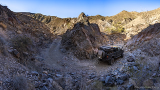
A narrow vehicle made easy work of several tight turns in the wash.

Emerging from the narrows.
A third of the way through the loop, I encountered the first mine that I planned to check out. This one, it turns out, belonged to Martin Augustine - for whom the pass was named - and was one of several mines that he discovered around 1920. While he optioned most of the claims off in the early 1920s, he continued to work this one until shortly before his death in 1945.

An old shaft, the entrance partially covered as the hillside around it crumbles.

Only about 15 feet deep, the ore here probably didn't pay well. Later, it appears to have been used as a place to escape the harsh desert conditions.

All that remains of Augustine's camp are a few barrels and some scraps of wood. No buildings or mining machinery. 

The remains of Martin Augustine's well cap.
Now at about the halfway point of my loop, it was coming up on 6:00pm and I realized that even with the later sunsets, time wasn't really on my side. Rather than rush, I figured there would be countless suitable spots to camp in this maze of canyons, and purposefully slowed myself down to enjoy the scenery around me.

Ka-pow! Green barked Palo Verde tree.

This teddy bear (Munz) cholla group appeared to be running towards me - arms outstretched for a hug.
Fair warning: DO NOT HUG CHOLLA.
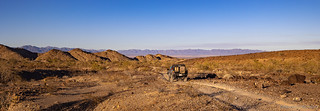
On the north side of the Chuckwallas now, I-10 was barely visible in the distance.
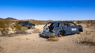
Not all the scenery was of the natural variety.
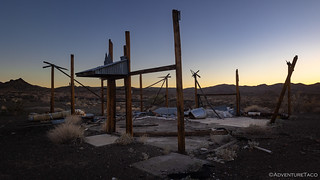
It was only a few minutes later that I made an unexpected - but completely exciting - discovery: an old mine site with actual structures! This, it turns out, is the Talking Rock Wash #2 mine. While no longer active, it was worked - or at least registered - up until 2017 when it was taken over by the Bureau of Land Management (BLM). Still, the site is recent enough and in good enough condition, that should you visit, be sure to take care that it remains a nice place to discover!
A very nice stone storage shed, with some new hinges to boot!
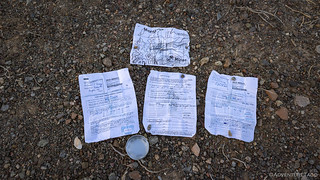
As with any good claim, paperwork is key!

With a loading ramp supported by telephone poles, ore was dumped into the chute before being transported by conveyor to a (no longer on site) mill.
This being the first historical mining site that I could really explore, I probably spent longer at it than I should have, and I had less than 30 minutes before sunset when I finally got back underway. With a possible destination in mind at this point, I whizzed by the Chuckwalla Spring, a small arch, and a hoodoo named Lot's Wife in an attempt to make it before the sun dipped below the horizon.
Chuckwalla Spring wasn't overflowing with water, but there was definitely a bit down at the bottom of the hole. Enough at least for smaller animals that could navigate the six-foot drop.

As I squeezed through a narrow section of canyon, I'd apparently uncovered the Chuckwalla Arch!

Lot's wife. Not the most dramatic hoodoo I've seen, but nice in the evening light.

Even more than on the earlier parts of the loop, this second half of the loop was full of color. Even as I stopped to photograph these rocks, I wouldn't fully appreciate the extent of the canvas until the following morning.
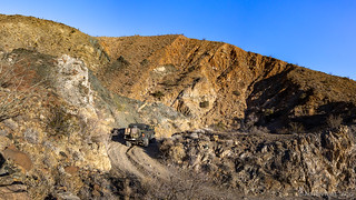
I arrived - at the site of the Southern Desert Gold Mine - with only moments of sunlight to spare. Active until 1987, it was an open-pit operation that was clearly quite a bit larger than anything else I'd run into in the area, though vandals had obviously gotten to whatever was left and essentially destroyed it.

The mountains glowed a fiery red as I started to look around.
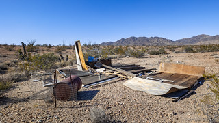
The old workshop, only the shelter above the entrance still intact.

Troughs and piping used to move gold-bearing ore as it was processed.
With light fading, I spent significantly less time at the Southern Desert than I had at the Talking Rock Wash, and soon I was headed back to a low rise that I'd passed on my way in. While I knew it wouldn't be the best place for sunrise in the morning, I hoped it would provide at least territorial views, and a bit of shelter should the notorious winds pick up during the night.

Looking north, the Belt of Venus made for a calming evening as I snacked on granola bars and an apple for dinner.

Just as the last light was peeking over the horizon, I got the tent set up and climbed in for an early night.
The Following Day...
I slept fabulously there on my little knoll. A light breeze blew through camp all night - enough to keep air moving through the screens of my tent, but not enough to rustle the rain fly - and temperatures cooled from the triple digits to the low 60s °F by the time I arose the next morning to catch the sun coming up over the hills to the east.

The first thing to catch the sun was the moon, and an early morning flight out of... LAX?

If I didn't know better, it would almost seem that the previous evening's purple faded into this morning's pink.
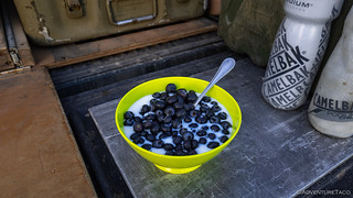
Having learned from my mistake the previous day, I ate my "cereal" breakfast before the sun was beating down on my camp. Note: there is no actual cereal.
Camp was stowed and I was on my way by 7:30am. I was looking forward to this area quite a bit as Mike @mk5 had described it as just my kind of place:
A network of canyons [where] time and time again, we found ourselves thwarted by dead-end after dead-end.
[Even so] I can’t overstate the spectacular beauty of this area’s geology, and it seems unfair to characterize it as a network of dead-end canyons, even though, to be clear, it is absolutely a network of dead-end canyons. But it’s also a museum of nature’s splendor, with each turn of the trail revealing a new gallery of prehistoric artwork—a true testament to the divine improbability of our natural universe.
After a couple hours of exploring this place, we were faced with overwhelming evidence that I was lost and had no idea how to get back to the main trail. I started to wonder if a recent flood or landslide might have closed the route. With dwindling hope and a complete lack of cellular service, maps, or preloaded waypoints, I made a drastic last-ditch decision to save our adventure: I decided to actually follow the directions printed in our guide book, which had been at my fingertips for literally the entire time.
The hardest part of this plan was putting down my cellphone and actually looking at my surroundings for like three seconds. With my mind slowly acclimating to the concept of non app-based navigational aids, I finally plunged into the 20th century torture of, like, reading book words or whatever.
Luckily, I'd come prepared with a nice route punched into my tablet, so there was no "getting lost," for me. Still, I wandered my way around for a good 45 minutes, just so could experience some of the same spectacularly beautiful dead ends that Mike had a couple years earlier.

"Dang." A dead end. What a "bummer."

"Shoot." It's really "too bad" I made my way down this fork of the wash.
Eventually of course, my knowledge that there were many miles left in my journey got me headed the right direction, and by now the sun was thoroughly heating the air around me. As I pulled out of the washes and up onto a road that would follow the ridgelines back through the Chuckwalla Mountains, I caught my breath as the colorful rocks I'd been seeing the previous evening an morning were all placed into perspective.

Did someone spill paint on a massive scale? What in the world am I looking at?
Look back at where I'd been.

And forward to where I was going.

Cholla forest. Warning: not cuddly.
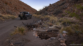
It wasn't long before I'd nearly reached the terminus of my loop so I could continue along the Bradshaw Trail - the only thing left to explore was the old site of the Chuckwalla Well Stage Stop. I'd expected this to be like the other stops - non-existent - and was delighted to find that there were actually still clues to its existence!

As a stage stop, a place to hitch your horses is an absolute must.
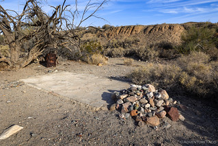
These rocks once formed the walls of a building on the concrete pad - a place to get out of the sun and out of the saddle for a few minutes.
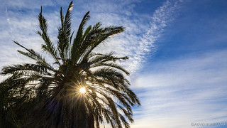
A lone palm still stands at the well, a sunstar peeking through.
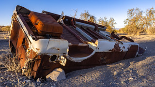
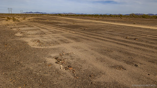
After leaving the stage stop it was less than a mile to the main trail, but a couple stops meant that it was one of the slower miles I'd travel on this journey. First, there was a prime example of desert pavement, and then of course, there was the COVID-19 boat.
This desert pavement forms through gradual removal of sand and other fine particles by the wind and intermittent rains leaving behind the large fragments. These larger fragments are fit into place by rain and wind, and then patinaed to a deep brown. While easily disturbed by vehicular travel, it's amazing how protective this surface is of the finer sediments below.

Desert pavement is like the crust in places like Canyonlands National Park - it takes decades or more to form, but is easily ruined by careless visitors. Stay the trail.

This boat isn't all that notable except that there hasn't been water here for... centuries, and some goofball before me had noted it in his trip report.
Finally, after more than 15 hours, I was back on the main route and headed east. For all of about five minutes. To my right (south), a windmill caught my eye and I followed a well-travelled road to take a look.

The only standing remains of the old Bell Ranch is the windmill. Still spinning like a top in the brisk morning wind.

In their day, views from the ranch were nothing to scoff at!
For no other reason than a morning that was even warmer than the previous one - temperatures in the mid-90s °F by 9:00am - I was back in the Tacoma as quickly as I could be, and on my way east.
Sort of.
You see, I'd just happened to pull over to photograph a second boat skeleton on the side of the road, when I heard a droning sound in the distance. For the third time on this trip, I seriously lucked out when it came to military aircraft - within a few seconds, a C-130 Hercules powered by just a couple hundred feet overhead!
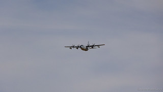
My initial thought was, "well, this is cool!"

Right about now, I was thinking, "Holy shit, this is awesome!"

And finally, I was like, "Hell ya!"
I've never had a plane so large and so low that I had to zoom out my camera to fully fit it in the frame, so you can imagine how exhilarated I was with this experience. In fact, I nearly forgot to snap a photo of the boat I'd stopped to capture, as I furiously reviewed the C-130 photos on my tiny viewfinder.

The boat was suddenly a lot less interesting.
Back underway, finally.
I suppose all the stopping I was doing shouldn't have surprised me or anyone, but I was glad for a few uninterrupted miles of air conditioning in order to reduce the sweating that seemed to break out immediately whenever I'd exit the truck. The road here - finally - was smoother than it'd been, and it was great fun to push the suspension a bit as I raced through the desert.
Of course, I'm not the first one to have raced through these parts. More than half a century ago, The US Army used this area for light tank maneuvers as part of the Desert Training Center, and even today - all these years later - their impact on the desert pavement is apparent.

Tank tracks still scar the desert pavement next to the Bradshaw Trail.

M3 light tanks training for war, many years ago. (US Army Archives)
Nearby, these rectangular outlines on the desert floor were where a small tent camp had been erected for troops practicing nearby.
From this point, I had only two more quick stops before this second - of three - segment of the of trail would be in my rear-view mirror.
First on my list was the Mule Spring Stage Station. Unlike some of the other stations that have roads leading directly to the site, only a small cairn marks the location where one must start hiking to reach the Mule Spring ruins. Luckily, I spotted it along the side of the road, and set off on foot, once again, the research I'd done prior to embarking on this journey coming in handy.
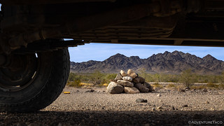
I suppose that many people never notice this cairn, or wonder if it has any meaning.
Only a few crumbling rock walls remain from the Mule Spring Stage Stop; still, it's more than any other stop along this route.
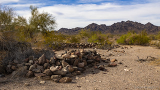
My final stop was one that I'd really been looking forward to - a pair of charcoal kilns. Unfortunately, the promise of a "still mostly standing" kiln was unrealized, the 30 years or so since the Gold Road to La Paz was written having taken their toll on the adobe-barbed-wire-and-manure structure.

Two piles of rubble were all that remained of a pair of charcoal kilns built by Walter D. Scott of Blythe during the 1950s.

Nearby, a dwindling pile of the charcoal that Scott supplied to nearby mines for the operation of steam-driven equipment.
And with that, I'd nearly reached the end of the Chuckwalla Bench. Before me, the final phase of my journey - into and through the Mule Mountains - rose up in the distance.

Into the Mule Mountains.
It was the section I'd been looking forward to the most, and one that would definitely not disappoint!
.


 Bradshaw Trail #4")
Great trip report as always. One small unimportant point of clarification to your story…the 4-engine prop plane you saw is actually a C-130 Hercules. I only know because they fly over my house on an almost daily basis.
Thanks Richard, glad you enjoyed the story, and for the plane identification! I'm pretty much useless when it comes to knowing various planes, so it's always awesome to have someone who knows, chime in! ? I've updated the story.
Yes, we’re in the flight path for NAS Pt. Mugu so I get to see all the planes you see in the DV area, coming back from aerial exercises. I’d rather see them from your vantage point!
When we were on a trip in the Saline Valley in 2019 two Ospreys flew right over us. Cool.
As far as big planes go several times I have been driving in Eastern Washington generally around Yakima or the Tri-Cities and suddenly will look to one side and there is a B-52 probably no more that 400' above ground. I usually don't hear them due to road noise and often having the windows up and AC on. They remind me of seeing a giant horned owl that used to inhabit the oak woods that my brother and I used to spend half of our summers days in when I was growing up in Omaha. That owl was absolutely soundless and sometimes it would fly fairly close by and disappear behind trees without ever flapping it's wings. I bet that owl thinned out our neighborhood cat population as well as the rabbits and squirrels.
Liked the road grading fence! When a friend had a mining claim east of Red Mountain we had a 20' long piece of chainlink fence with several railroad ties fastened to it and a heavy chain yoke. Each time we went to the claim we'd drag the bit of fence with us on the dirt road, both ways then leave it there for next trip. Did well to maintain the road. As for your Ospreys, we have all kinds of interesting aircraft go over daily, tons of C-130's, today some raptors, but a couple of weeks ago I heard what sounded like some very large helicopters coming over (we also have all kinds of helicopters) and looked up to see 2 Ospreys, they came and went many times over two weeks. Maybe the same 2 you saw? Today we ventured up to Red Rock Cyn and Jawbone Cyn, fun trip and not too hot. Planned to go to the Opal Mines in Red Rock and got within 1/4 miles when we were running out of time and the road had become extremely soft and deep so didn't make it all the way. The road is quite bumpy but also fairly wide in most places but it is very loose sand and gravel so wouldn't recommend to TWD or inexperienced people. My truck has some large/wide tires and only had a few places that lost traction. All in all a fun day and yes, a number of jet fighters were overhead from EAFB. Living between EAFB and Plant 42 means we have constant entertainment! Really liked your latest Bradshaw Trail adventure & I ordered the book which should arrive Saturday.
Sounds like a fun trip out there John, and with some overhead excitement! Hope you enjoy the book - some of it is out of date from a routing perspective, but it has some nice history of the trail, and various tidbits that added to the adventure for me. Given that it was written decades ago, I was surprised how much of the landscape/landmarks haven't changed!
I started leading groups on the Bradshaw Trail in 2008. These articles bring back memories. I do remember the mines over Augustine Pass and the difficulty in route finding in that area. I simply could not follow the directions in the book. Eventually, I would find my way, and I was tracking with a GPS equipped laptop and TopoUSA.
The second mine you mentioned, back then, had several large tower structures and lots of equipment. Over the years the equipment got removed for salvage, probably. By whom (legal or not), who knows?
Just replied to your last comment, and I'm glad you found the stories to bring back (hopefully good) memories!
It does seem that mines on - or really, surrounded by - BLM land have a tough time surviving the rigors of visitation, at least compared to those in places like Death Valley. More likely, it just has to do with the number of people who visit I suppose - as I'm sure there are more remote places on BLM that are still relatively well preserved.
I thought the "moon and jet" photo was one of the most unusual...not to mention the C-130 shots! Nice. UJ
Thanks! I thought the moon and jet was pretty cool too! You can actually see the contrail from that jet in the next photo as well.
Thanks for the "moon and Jet" reply. There have been several times around ██████ County almost always when I'm in a big meadow that those C-130's will fly LOW over. There can be anywhere from 1-4 of them. Several times at the Golf Course in ██████ Valley and EVERYONE stops whatever their doing and watches them fly over. The ones around here seem older than the one you got the shot of. And you can always see the exhaust from their engines.