
Hoping to get some photos before the sun was up and the cabin-under-a-rock was lost to the shadows, I set my alarm for too-dark-o'clock, and hit the snooze button a couple of times before finally pulling on my pants and climbing down the ladder to a beautiful morning.


Suddenly in a rush against the sun, I scampered up the hillside in search of a location where I could capture the entire camp. This - given the car-sized boulders that stood in my way - was a ton of fun, though I could have done with some gloves to keep my hands a little warmer this early in the morning.


I didn't wander around long before the sun was up and - like the moon the previous evening - a dark shadow began chasing me down off the hillside from which I was looking down on the cabin. With all that reflected light, it was time to get a closer look at the structure itself - and the interior - before heading to a digging that I saw a little further up canyon. And by now, I wasn't the only one out exploring!


After poking around the cabin and other buildings - all of them emptied of their secrets after years of visitation - we set off to explore the tailings pile that we'd noticed a little further up the hillside. Now in full sun, it afforded us a nice place to warm up a bit, our puffy coats, hats, and gloves all battling the cool shade that was likely prized by the one-time-occupants of this camp.

@mrs.turbodb made it to the platform first, and a grin on her face when I arrived suggested I was in for a treat. Sure enough - tucked into the mountain - an adit opening begged for exploration. Nothing screamed excitement here - like the cabin, surely this adit had been picked clean over the years - but I gathered up the LED puck lights and plunged into the darkness.


As always, fussing around with the LEDs in the mine took longer than I imagined it would, more than half-an-hour passing before I emerged into the daylight, my companion having cleaned up around camp, gotten breakfast ready, and re-organized the interior of the Tacoma. Perhaps, more, longer mine explorations should be in my future!  For now though, I quickly put the tent away and began to retrace a path we'd previously seen only under the illumination of the Diode Dynamics SS5 pods.


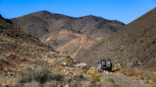
Before long, we completed the lollipop section of trail to the cabin-under-a-rock and turning east, we hoped the trail out would be easier than the trail in. We'd soon find what we hoped was a good sign, and - as any good Gold Rush fans would do - we stopped to take a closer look.


The Cat had been hard at work and in no time - by which I mean more than two hours faster than our trip in - we were speeding along Teel's Salt Marsh in the Marietta Wild Burro Sanctuary, toward the ghost town of Marietta and a slew of mines tucked into the surrounding hills. Not that any of them were necessarily worth exploring.
There turned out to be more in Marietta than I'd realized, and as the history of this place was revealed, we stopped to take a look at a few of the old ruins and the sparsely populated cemetery.


Established in the late 1870s, Marietta was not a typical central-Nevada mining camp. Its fortunes were based not on gold and silver, but on borax and salt. The salt mine was first developed in 1867 at Teel's Marsh, one of several salt marshes in the area. The salt was transported by camel to Virginia City, where it was used in processing ore. The borax was discovered a few years later. Marietta grew up out of the Teel's Marsh borax operation in 1877, and within a year it had several businesses and more than 150 residents.
Francis M. Smith, who would soon achieve renown as "Borax" Smith, was working in the Columbus Salt Marsh, about twenty miles southeast, when he learned about Teel's Marsh in 1872. He took a sample from a dry lakebed there, and it proved to be rich in borax, or colmanite. Smith immediately staked a claim on much of the area. Full-scale borax mining began within months of the discovery. Smith and other miners constructed borax-processing facilities at the southeastern end of the marsh. Wagon trains hauled the borax to the train depot at Wadsworth, about 115 miles north.
The success of the operation led Smith to create the Teel's Marsh Borax Company, precursor of the Pacific Borax Salt & Soda Company, which eventually controlled the world borax market. Smith's genius was in recognizing that the mineral could be profitable if marketed correctly. Prior to his efforts, borax was used primarily in pharmaceuticals. Since he was sitting on such large reserves, Smith began promoting the substance as an effective cleanser. He created an immense market for his product, and in the process became one of the era's most successful industrialists. Smith eventually moved farther west to larger borax deposits in Death Valley and became famed for his twenty mule teams that carried the borax out. His naming the product Twenty Mule Team Pure Borax was another example of Smith's marketing acumen.
Smith's departure after the borax discoveries in Death Valley meant the eventual end of Marietta. By the 1890s Smith's company had ceased mining there, and the town began its slide into oblivion. Today the most prominent ruins are the stone walls of Smith's company store. East of the store is the foundation of the stamp mill and, buried in the sagebrush, a handful of dirt mounds where the town cemetery was.
In the 1990s the federal government created the Marietta Wild Burro Range at Teel's Marsh, the nation's first wild-burro refuge, setting aside 68,000 acres as rangeland for about eighty-five burros. Visitors can see the burros from designated viewing areas [known as "the desert"
] around the marsh.


I'd marked a maze of roads leading to more than a handful of mines in the hills behind Marietta. While only one of these appeared to have anything of interest in satellite imagery, we spotted a couple structures a mile up the road and decided that they ought to be the first on our list.
Or not. Less than 500 feet further, a cable gate was strung across the roadway, our path blocked.

Ultimately, my maze was reduced to a single passable trail, the various branches either similarly gated or unused for so long as to be untenable for travel. The passable trail however, was splendid. Recently graded, it was as though work was once again set to begin at terminus of the road - the Endowment Mine - though clearly no actual mining work had been performed.


The Endowment Mine was the first mine in the Marietta district, producing silver-lead ore in the late 1800's. Several thousand feet of workings - including three winzes and numerous stopes and raises - perforate the mountain on five different levels.
By 1877 - near the height of production - the mine and five-stamp mill (soon to be replaced by a ten-stamper in 1878) employed as many as sixty men, with shipments during the month of September amounting to over $16,000 and new mineral discoveries at the 400- and 500-foot levels were said to be worth $155 per ton.
As with many mines, production fell off dramatically, and by the late 1880's, the mine was no longer in operation.
However, while many Nevada mines closed during World War II, the Endowment Mine and its owner at the time, Mark G. Bradshaw, was granted an exception to produce the lead, zinc, and silver - now vital as strategic metals - for the war effort.


The buildings were interesting, but the highlight of the Endowment was our discovery of the adit entrance, just behind a rather large pinyon pine tree that'd grown up next to the wash. Several elements of this adit were intriguing, and somehow I even got @mrs.turbodb to venture in a few hundred feet - with only a few four-letter words and "this real doesn't seem safe" statements echoing as we plunged deeper into the darkness.


 🦇
🦇It took us about an hour to check out everything - that we were comfortable looking at without more lights and ropes - at the Endowment mine, and knowing that we had another big exploration slated for the afternoon, we pointed the Tacoma back down the road towards Teel's Marsh where a quick drone stop allowed us a closer look at the mine-behind-the-gate that we'd spotted earlier.


By now, it was 1:30pm and we needed to get a move-on if we were to make it to our campsite - one I'd been anticipating for many months - before nightfall. In reality, we had no chance of making it before nightfall - we'd be lucky to squeeze in dinner before it was dark - but we were naive enough not to realize how long the next foray into the mountains would take.
 )
)We weren't really going all that far - just over a range towards Rhode's Salt Marsh - before heading up a nearby canyon. Like those around Marietta, these were - at one time - covered with active mines, few of them successful and all of them now out of commission. Of them, the Silver Dyke mine - obviously a Tungsten operation (duh! ) - was the one we sought on this fall afternoon.
Climbing to just over 6,500 feet, we were making great progress as we passed through what appeared to be a series of old miner cabins and the foundation of a mill and around a corner that revealed a large wooden ore bin towering over the wash.

It was right about here that the road became significantly less traveled. Still, it seemed doable and - like good American's, avoiding physical exertion at any opportunity - we pushed on with the skinny pedal.
Of course, that lightly traveled two-track should have been a hint, and a quarter mile later - about halfway to the ore chute and associated tailings pile - the road was completely washed out. The hillside above - as well as the hillside below - had fallen away, only a narrow foot trail winding along the scree field. It was time to back down.


We didn't spend long at the ore bin, mostly because I'd marked a waypoint for the mine a little further up canyon. Actually, it was behind - or as it would turn out, on top of - a nearby hill, and with the non-satellite maps we'd downloaded for offline use, it was hard to tell what route would be the most efficiently deliver us to our destination.
It's here that I should mention my takeaway from this conundrum: namely, when route planning before a trip, it's easy to look at satellite imagery and think, "I'll remember this when we're on location." The reality is - at least for me - you won't. Often times the planning takes place weeks (or months) prior to the trip, and at the very least, there are a half dozen or more of these places that will just be remembered. A better idea - and one that I've adopted after this trip - is to mark any interesting structures with some guessed label (e.g. old mill?) - and to also enter any notes that will be helpful when on the ground. Possible routes, for instance!
At any rate, our only option was to pick a canyon and hope for the best. So, left it was!


Eventually, we came to the remnants of a couple old cabins. Built onto terraces on the side of the wash, both had collapsed completely in the years between the abandonment of the mine and our visit, but the plethora of mattress frames and old stoves - perhaps the most common trash we find in the desert - left no doubt that a night or two were spent in these parts.

(As of today's closing, up 795% to 34,338.)
Pushing higher, we now realized - simply by looking at where I'd marked the general area of the structures I'd seen on satellite - that the Silver Dyke must have encompassed most of the ridge between the two canyons we'd considered hiking. As such, it seemed only prudent to scramble up one side and down the other, turning our much-longer-than-we'd-anticipated hike into a loop.
Hopefully we could do it before the sun dropped below the horizon. You know, because we hadn't brought any water, warm clothes, or food. #AlwaysPrepared

Making it to the top, we finally spotted the point at which I'd marked what I'd thought was interesting about this mine. There, on the opposing hillside, several tailing piles spilled down into the canyon and near the bottom, a headframe and shed were nestled into the trees. Picking our way down, we headed in that direction.

Just around the corner from the workings, several old hand-stacked stone foundations climbed up the steep hillside - foundations for an old mill. Two timbers - each more than 50 feet long and 24 inches square - rested on one level. On another, an enormous piece of steel rusted along the old access road.

By now it was obvious - even to us - that an exploration that we'd expected to take half-an-hour was going to end right around sunset. As such, we decided, the prudent choice would be to make dinner when we returned to the Tacoma, rather than driving to our final destination for the night before filling our bellies. No matter what - with three hours of driving - we were going to arrive well after dark; we might as well eat dinner while it was still dusk.


Dinner done and the sun below not only the hills but the horizon, it was getting colder quickly. Gear was stowed, and we climbed into the cab, the heater working furiously to blow cold air onto our extremities until the engine warmed up enough to spare a bit of the love with the occupants. We'd had a full day of mine exploration - all three sites a smashing success - and so it was with high spirits that we pointed the Tacoma downhill towards US-95 and ultimately, for the ghost town of Nivloc.
It was a place I'd been wanting to visit since I'd sleuthed it out in my incessant investigation of Google Earth. A place that was no secret but that seemed reasonably unknown. A place with a full-intact railroad trestle.
The only question that remained - would we be allowed onto the property to check it out, or would the whole thing be secured behind locked gates? Only time would tell, and we probably wouldn't know until morning.


That is an outstanding photo of the belt of Venus. How much did you have to tweak what came out of the camera? I have never been so successful.
Thanks Anthony! As you might imagine, there wasn't much light at this time of day, and since I was hand-holding, I was also shooting at -1EV, so I definitely had to up some of the shadows and saturation values as you might imagine. But, the belt was quite obvious both when we were there (hence the photo 😉) and in the original RAW.
Here's a low-res side-by-side of what I got. Click the photo for a larger version.
Nice finds !
Thanks!
Bass camp? You into fishing now?
Sorry! I couldn’t resist.
I mean, I LOVED fishing as a kid. I feel like the only fish in this neck of the woods, though, would be the miners special. You know, brown trout. 💩
No rivers, creeks, streams, or lakes anywhere in the vicinity.
I guess you did not “get” my subtle reply. Base camp as opposed to Bass camp
I thought I did get it, hence the fishing jokes. 😉
Never saw anything about "basE" camping though (or that went right over my head, hahaha!
Bet that drum with hinged lid and hole was a vertically standing wood stove.
Been to Murrieta and Teels marsh, but need to visit cabin under the rock.
Had heard road was washed out.
Thanks, Greg
I thought it might be a stove too, but the hole/lid situation seemed a little off to me.
The road in from Teels is passable if it's been recently graded (it climbs a reasonably major wash that can quickly be destroyed). Don’t come from the west side though, that’s a nearly impassable slog and completely unmaintained!
Those are some awesome ruins...I'm jealous!
Not sure if you are still running around Nevada, but if you are, try to find a way to swing through Candelaria. I stumbled across it by accident about 15 years ago. There is a working mine there, or there was then. There are also the ruins of the old town that used to be there. These consist of some stone buildings that are in about as good shape as those at Rhyolite.
You can find it at █████████, ███████████
Thanks Tom! We're back from the trip at this point (by the time I've gotten around to processing photos and writing everything up, we're usually home for a week or two), but we (or really, @mrs.turbodb) read about Candelaria as we were putzing around down there, and she even suggested we go! I - always the downer - was like, "we've already got plans," so I suppose we'll need to make another trip to check it out.
"Shucks." 😉
That barrel looks exactly like the one found in the mine. My guess would be some sort of tumbler. Also, the land for the Mine Behind the Gate, shows on Gaia as owned by BLM (private land layer), even though the shading on the satellite view shows private. That is unusual. Maybe it reverted back to BLM and is accessible?
Yeah, I think it's some sort of tumbler as well; makes a lot of sense given the location and