
I don't know how cold it was when my alarm went off just before sunrise in the Tobin Range, but despite the fact that we were several thousand feet lower in elevation, it felt colder than waking up at the top of Lamoille Canyon. The fact that the entire tent - and the top comforter - were covered in a thin layer of dew-turned-to-ice probably added to that perception.
I knew we wouldn't be getting any sun in our bottom-of-the-canyon location, so instead of dwelling on the wet tent, I found myself hoping that the drone wouldn't complain too much about battery temperatures as I launched it into the sky.
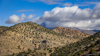
We'd parked near the Eureka Mine, but my first order of business was to fly a couple miles away - and some 1800 feet up - to see what we'd missed the previous evening at the Tip Top Mine.


The drone is fun to fly in wide open spaces like this, and I spent a few minutes swooping here and there, eventually working my way back towards camp. Unlike my fingers - which by this point were numb - the drone battery was finally warming up, and a rather disconcerting message about imminent failure due to "Battery temp too low..." finally faded from the screen of the controller.


Soon enough, the drone was back on solid ground, and I was stuffing my hands in my pockets as I woke @mrs.turbodb to let her know that I was heading over to the mine. After inquiring about the temperature - which I may have oversold slightly as being "not that bad" - she let me know that she'd abandon her cozy cocoon and follow in a few minutes to check it out.
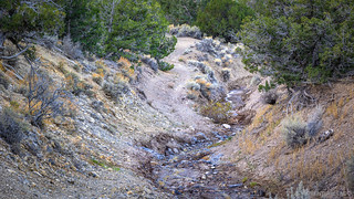
I'm not sure when, but the last few hundred feet of trail - between where we'd camped and the cabins - washed out at some point, the creek carving a 4-foot deep, 10-foot wide gully where the trail had once been. The "go around" that has been created is an off-camber disaster that'd kept us from pushing all the way to the end of the road the previous evening. With a bit of daylight, we measured the height difference at the 55" track width of a 1st gen Tacoma and came up with 38".


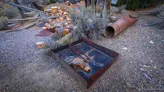
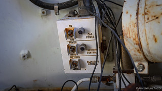
Active from 1955-1958 and then again from 1968-1970, the eureka mine produced more than 100 flasks of Mercury in 1956, though production trailed off from there. An inclined, oil-fired retort with two D-type chambers was used during the first period, resulting in more than 250 flasks of Mercury in ground that contained more than 200 pounds of Mercury per ton of ore.
The original mine owners - Low and Fred Miller of Basin Mining Company - sold off the mine to Harry R. Brown in the 1960s. Though Brown would work the mine until 1971, he'd recover very little additional Mercury, eventually selling again to F. J. Miller & Associates, who have not worked the mine since that time.


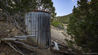
About this time, I heard a whistle from the main camp area below - my companion was up and about and enjoying her own path through this old mining camp. Excited to show her the retort, I ushered her in that direction and wondered again at how the crazy contraption worked.
By that point, we'd pretty well exhausted what there was to see in the camp, but we could see an orange tailings pile and what looked like an open cut on the hillside above, so we continued to follow the road out of camp - in what seemed like entirely the wrong direction - which eventually led across the wash and up to the mining area.


It wasn't yet 8:30 in the morning when we headed back to the Tacoma. At the bottom of the ravine and still in the shade, the layer of ice - both inside and out - was unchanged from our last observation, and without some intervention, it wasn't going to dry out anytime soon.
Luckily, we had the perfect solution - fold the thing up wet, drive up to the saddle where a fork to the Tip Top Mine took off up the hill, and unfurl the tent in sun while we hiked up to investigate. With any luck it'd be dry by the time we got back, and if it wasn't, I could manually dry it while @mrs.turbodb assembled turkey sandwiches on the tailgate.


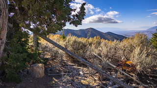
At just under 1.5 miles, It didn't take long to get to the mine - or at least, what was left of it. Like the Eureka, the Tip Top Mine was a Mercury mine, though it was only a surface mine and a much smaller producer. There wasn't much left - evidence of digging, a relatively small waste pile, and a few boards that were once a small cabin.

After a quick lunch - prepped while I put away the now wonderfully dry tent - we climbed into the Tacoma and headed west. It was noon, and we had a lot of ground to cover if we were going to get to Walker Lake by nightfall.
We didn't make it far before I was out of the truck snapping photos. As usual.


Out of the mountains, roads smoothed and our speeds increased dramatically. It was perfect, really, for those of us not driving to sneak in a quick after-lunch-nap, making those of us who were driving, just a little bit jelly. Turns out the private-land-gods were looking out for us drivers though, a few rather intricate gates requiring the nappers to get out and open them.

Twenty miles later we transitioned from Pleasant to Dixie Valley, plumes of steam rising in the distance. My copilot - now unable to sleep after hopping in and out for the gates - was all over this development, discovering in the Roadside History of Nevada that what we were seeing was the Dixie Valley Geothermal Power Plant. Positive that we wouldn't be allowed close enough to get a photo, I pulled over on the side of the road, climbed onto the tent in the back of the truck, and pointed my longest lens toward the complex.

Any concern about the approaching pickup was quickly alleviated - after a short spike of adrenaline when it slowed to a stop and the window rolled down - when the driver asked us if we knew our way around. Like us, he was just out exploring, not at all associated with the top-secret generation facility that I'd snapped a few photos of.


The highlight of the plant, however, was not the plant itself. It was a nearby strip of pavement - and corresponding structure - that caught my attention and required a more in-depth investigation. After all, where better to park than in an empty airplane hanger or on an active runway?


Sure that we'd experienced the best that Dixie Valley had to offer - but not knowing much of Dixie Valley at all - we pulled off the runway and resumed our southward heading, a few hours of dirt remaining before we'd join US-95 at Luning. To us, Luning is a rest stop, though it is also technically a town - that one of us calls the loneliest town in the United States, second only to nearby Mina.
Predictably perhaps, we were completely wrong about Dixie Valley.
When the town of Dixie Valley was first founded in the late 1800's, it was to mine the salt, potash and borax discovered in the area around 1861. In addition to minerals, the valley also sported a copious water supply, a feature that was largely ignored until the early 1900's. Until then, a sum total of fifty families were ranching the valley, using the natural water spewing from underground springs to grow alfalfa and raise cattle for nearly a century.
In 1955, the area was acquired by the US Navy to be used as part of the Fallon Range Training Complex (FRTC). As part of this acquisition, all residents of the valley were relocated - many against their will - in many cases, their land and buildings demolished in order to deter them from returning.
The FRTC has served as a vital and irreplaceable asset for training naval aviation forces for more than 75 years. The FTRC includes four Bravo (B) ranges and the Dixie Valley Training Area, typically used for convoy training, fixed‐wing and helicopter night-vision device training, helicopter mountain‐flying training, and combat search and rescue activities. The ranges are used to train deploying air and ground units in a realistic environment and prepare them for overseas operations.
It was the last point that would turn out to be the most interesting, but before we would discover that, we stopped at the old abandoned Bar3 Ranch so we could wash our faces and bodies while temps were in the low 40s °F, rather than nippier temps we'd been getting once the sun went down.


We weren't sparkly clean, but - after a good scrubbing with washcloths - we were both grateful to be cleaner than we'd been, and once again we headed south along the west side of what we'd soon discover to be the Dixie Valley Training Area. So mundane was the drive that I don't even remember what each of us was doing when I happened to glance to the east and then pressed firmly on the brake.
"Hand me the binoculars, I think that’s a tank out there!"
@mrs.turbodb wasn't all that surprised, so she must have been reading about the range as we were driving through it. Regardless, once I confirmed that I wasn't imagining a tracked beast in the middle of nowhere, a new urgency - finding a way out there - became our top priority. After a bit of map tapping, we set off, looping around and eventually finding ourselves pulling into formation.
If anyone knows what types of tanks these are, or any history of these particular specimens, please do share - comment below, email me, whatever!


We probably poked around on that first tank long enough that we were lucky to escape a live bombing run from the good folks from Fallon. Eventually though, we had to move on, a second tank (again, please share if you know what it is) not more than a hundred feet away, the rear doors open as though the infantrymen had run for their lives.


It was - as you can likely tell - a really fun experience. Surely there are more of these beasts in the valley, and with a bit more time, it'd be fun to find them all. Today, however, we had places to be, so we reluctantly climbed back into our indestructible steed and resumed our journey south. Along the loneliest road in Nevada.

We arrived in Hawthorne - our route technically taking us next to Luning, sorry Luning - just before sunset. The largest town we'd pass through on our journey, we made a quick stop at the grocery store and filled up the Tacoma with fuel before heading to nearby Walker Lake. We've spent the night on the edge of the lake numerous times - usually in a push to somewhere much further south - so we knew that while earplugs would be necessary to filter out the noise of truck traffic on the highway, we'd have nice views and an easy jump-off point for the morning.
Luckily, given that with the sun below the horizon it was cold, a dinner of chicken wraps and camp setup were quick, allowing us to jump back into the still-warm cab of the Tacoma for an hour or so of reading and photo transfers.
By then, it was 7:30pm and pitch black outside. Or as pitch black as it could be with the full moon rising in the east over Walker Lake.


It was time for bed.


The first one looks like a modified Shillelagh light tank. This airborne tank normally had a 152mm main gun that was sized to fire a guided missile, as well as large caliber, low energy cannon shells. This one has a small caliber barrel, which I’ve never seen before. The second one is an early version of a M109 mobile howitzer artillery piece. I don’t have a clue about the contraption on the top. Definitely not standard issue. Pretty cool find!!!
Thanks Hans - always great to get this kind of info from folks who know (so much) more than I do! I was wondering if the barrel on the first tank was "installed" after the fact, perhaps for looks/profile only. Seemed pretty thin walled to me for firing anything of substance.
Perhaps a fancy potato cannon?! Agreed, the barrel walls didn’t look very substantial.
I mis-identified the tank. I called it a Shillelagh, but that was the name of the missile fired by the tank. The tank is an M551 Sheridan.
There are tanks, Bradley’s, jeeps, half tracks and more all over DV. Most of the old homesites have all disappeared in the last 20 years with only a handful remaining. Too bad you didn’t have more time to spend there exploring the crystal clear aquifers and old mine sites on the east side of the Clan Alpine. You must have missed the Iraqi “village” training site on the east side of 121. That’s an interesting stop.
That final hundred feet into the mine looks a lot steeper in your shot. I was sure I was going to end up in the ravine when I traversed it on the way out in the rain.
Cheers,
T o m
Morning Tom, It definitely would have been fun to spend more time in Dixie Valley - certainly if we'd known more about the history and what was there from a target range perspective we probably would have planned a day of exploration. As usual, just another place to add to the list to go back to... the result of a trip where we were trying to wrap up a bunch of those places in the first place, hahaha! 🤦
The mine sites on the other hand, we had no idea about, even after driving through. Yep, we'll need more than a day in Dixie Valley!
That’s why I have been spending at least a week a year out there, every year for the last 30 years. I always find something I hadn’t seen before.
This year we are going to move it up a bit and head down there in may to get a jump on it before the mosquitos show up. Check out other side of the Clan Alpine range on the east side of the valley. War Canyon is a good track. You can follow the road north from Middlegate and take Shoshone Pass to re-enter DV north of the settlement area. It’s a good day trip circumnavigation of the Clan Alpine. Wonder is cool to check out too but last year the road was too washed out for my buddy driving his Ford. I’m sure I could have made it through.
Another great story and photos, thanks Dan. I used to truck produce and swinging meat to LA from Caldwell, ID passing through the towns you mentioned. The water supply to Walker Lake was said to come from Pyramid Lake in an underground tunnel. As I recall there wasn't any inlet or outlet.
Traveled Hwy. 6 past Mina to Bishop and down Hwy 395 to LA. Many times I drove straight through a 16 to 18 hour drive. In the days before the internet, one could cheat on his log books. Most of the towns along Hwy 95 had houses of horizontal refreshment stations ending at Montgomery pass called Janies Ranch.
In the winter you had to be on the lookout for cows laying in the roadway at night for the warmth of the roadway. A million-candle power spotlight would light up their eyes a mile away.
I wonder how old the miners at the mercury mines lived? I remember as kids breaking a thermometer open and rubbing the mercury on coins to make them look new, how did we survive this long with all the toxic things we encountered as kids.
Keep on Truckin!
Thanks Kenny, a place like this did seem to be right up your alley - the terrain somewhat similar to your usual haunting grounds - so it somehow it doesn't surprise me at all that you've spent time in and around these parts!
You're right on Walker Lake - no inlet/outlet. @mrs.turbodb was reading from one of her Nevada geology/history books as we went by, and as happens with those types of lakes, it's become more and more salty, to the point that the native fish (a trout species) began dying off,. A new species had to be introduced for the Native American Indians that still fished for sustenance.
And those guys with the Mercury are a lot like current day gold mining in 3rd world countries today, where Mercury is used to separate gold, and is then burned off. Definitely can't be the healthiest thing, but when that's the only option/tech available, humans do what they have to do.
Hope you had a great Thanksgiving and have lots of leftovers for the weekend!
Thank you. Another BDR... I enjoyed following part of the trip anyway!
Hoping you and the Mrs had a nice Thanksgiving!!
P.S. I'm enjoying the drone pictures.
Awesome find. Isn’t it Luning not Lunning?
I so enjoy your adventures!
It is Luning, thanks for catching that!
Dan, several years ago, WonderHussy on YT put up a video of Dixie Valley. She was in a different part, with different vehicles, but similar setting. There were some informed comments identifying the vehicles. You might find it interesting.
Thanks Tim! Just confirms for me that a return trip - now that we know more about Dixie Valley and what it, and the surrounding hills hold - is an absolute must. Would be so cool to see a few more old bits of steel!
The only tank in your pictures is an M551 "Sheridan" AR/AAV (Armored Reconnaissance/Airborne Assault Vehicle) developed during Vietnam. I worked on them while stationed at Fort Irwin, CA.
The other tracked vehicle is an M109 155 mm turreted self-propelled howitzer. I worked on these while stationed in Germany.
Thanks Bob! I always appreciate it when folks who know (a lot) more than I do take the time to help me out with identifications. I love finding this stuff out in the middle of nowhere, and it's always fun to be able to identify them after someone like yourself has weighed in! Hope you had a meaningful Memorial day, and thank YOU for your contributions to our country.
I hadn't heard of Dixie Valley until I read your blog. That led to a full fledged 1550 mile trip from N.CA to Middlegate Station, Berlin-Ichthyosaur State Park, Dixie Valley, Grantsville, Eureka Mine, Jumbo mine, Paradise Valley, Humboldt City, Tunnel Camp, Seven troughs and several others, ending at a remote cabin overlooking the Back Rock desert. We just finished yesterday, unfortunately a heat wave of 100+ degree temps and our black non A/C truck forced us to rush a bit and come home 3 days early. Our 36 year old Jeep Comanche handled the trip without a hitch. Thanks for the inspiration to plan what became an epic adventure.
Well, that's a bad-ass story Trey! So glad that a completely unexpected discovery on my part (I definitely want to get back to Dixie Valley to explore around some more) could be some part of what got you out for what sounds like an amazing adventure! I've heard of several of the places you visted, but a few are new to me, so I'll need to look them up and possibly follow in your footsteps! I'm curious - at the Black Rock Desert - was the cabin actually overlooking the playa, or was it further north with no playa view? (I might be familiar with that one, but I don't know of one overlooking the playa itself.)
Thanks for leaving the note, it was a cool one to get! 👍
It was definitely a distant view with the most beautiful scenery of the entire trip! We came in the back way from Tunnel Camp, it was a much more rough and beautiful drive than the way that we left. We were to the South of Black Rock Thanks for the inspiration!
Thanks for the hints, I'll have to see if I can find it! 👍