

We arrived at Nivloc at what appeared to be midnight but was - according to multiple timekeeping devices - only a bit before 8:30pm. Still, even under the bight-as-day moon, we knew better than to poke around this old ghost-town-mine-site in the dark, so we unfolded the tent, read the most boring books ever on our Kindles (me: Bourne Ultimatum, @mrs.turbodb: Open Veins of Latin America: Five Centuries of the Pillage of a Continent), and climbed into bed as I left the camera snapping one eight-second exposure after the next.
I'd hoped to capture some amazing timelapse of the stars - and perhaps Milky Way - cascading across the sky behind the headframe - but instead ended up with a rather boring series of 1600 Milky Way-less photos that I promptly moved to the "reject" folder on my return home.
You know what I always say:
"If you take enough photos, some are bound to be decent.
And a whole lot will be a stinking pile of poo."
The following morning...
Once again hoping to snap some photos before the sun crested the horizon - so as to avoid the shadows that would surely add all sorts of crazy contrast to the wooden structure of the train trestle - I was up before the sun and wandering around like a kid in a candy store as morning broke.


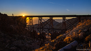
I could have wandered around for hours as the sun climbed into the sky, but I knew it'd be a lot more fun to share the discoveries with @mrs.turbodb, so I whistled across the trestle - which I'd now proven to be 100% safe™ - and soon enough she was bundled in three layers of clothes and ready for exploration.


With an audience, it was even more fun to threaten - and then execute - my daring stroll across what was surely the 100% most dangerous™ trestle in existence. However, try as I might - and I think I was close to success - I was unable to convince her that it would be a quicker way for her to get to the other side of the ravine as well.

The silver and gold deposits of Nivloc were first discovered by Tom Fisherman - a Shoshone Indian - in 1907, and a short time later were named for an early mine owner, William H. Colvin, by reversing the letters of his last name.
The mine soon faded, and it was not until the mid-1930s that the Nivloc mine was worked again. This time, it was Harry Stimler - the same man who, with Tom Fisherman, helped to get Goldfield started when they discovered the Sandstorm Mine - and as a result interest was more substantial. The property was soon developed with a large steel headframe erected over the 540-foot-deep main shaft and a large rail trestle constructed to transport ore from the mine to a nearby 200 ton-per-day cyanide mill for treatment.
A townsite was soon formed and a post office was established from 1940 to 1943. During this time - Nivloc's peak years of operation - over $3.9 million in silver and gold were produced. However, the mine was shutdown during World War II, and while substantion ore remains at extremely low levels in the mine, the cost of extraction has resulted in little work being done in the post-war years.


Turning back to the trestle, we marveled in its construction. It's rare to find something like this - in relatively good condition - at an old mine site with reasonably easy access. And, the more we looked, the more we wondered aloud to its use over the years.
Ultimately, we decided that the trestle had once served a shaft on the right side of the gully, the track continuing where it now appears cut off. Later, once that ore was exhausted, the actual trestle - over the gully to the left and to the not-very-interesting-at-night headframe - was constructed to take advantage of the same ore bin.

Even after all this, there was still more to discover. Climbing the ravine under the trestle - perhaps in another attempt to get the smarter of us to walk across - we found the entire hillside to be covered in crucibles! We've seen these before at a handful of sites, but never have we seen the thousands that were present at Nivloc. As I poked around looking to collect a range of colors - of which there seemed to be many, likely due to whatever was being melted inside - @mrs.turbodb found an old bit of slag that was amazingly light!


By now - having wandered around for more than two hours - it was getting on 9:30am and time for us to consider the remainder of what we had in store for the day. Largely, this consisted of more driving - nearly across the width of the state - to a location that I'd heard was the "perfect spot to park if one was interested in seeing low-flying military aircraft."
Since I am literally that person, it seemed like a great place to have a down day, and hopefully an air show. But, I'm getting way ahead of myself - we still hadn't checked out the Nivloc mine buildings!


I spent entirely too long looking at the core samples, and by the time we headed out of camp it was 10:15am. Also, we were heading the "wrong" direction, my always-finding-cool-things-to-investigate-in-her-history-books companion having discovered that a little further up the road was another large mine: the Sixteen-to-One Mine.
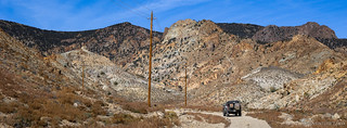
Most interesting to us at the Sixteen-to-One Mine was something labeled Ebley's Tunnel on the map. After my recent trip to Montana, and the surreal experience in the Boulder-Wickes Tunnel, I thought we might find a really cool adit that would be large enough that I could convince my daylight-loving companion to wander into.


This - we reasoned - couldn't be the tunnel, and while we did discover an adit entrance, it was nowhere near the spot that'd been marked on the map. Additionally, a thick cluster of willow - fed by more than 50 gallons of water per minute pouring out of the mine - were blocking the portal, which meant there was no way we were going inside.
I'll have to save that for a return trip. Perhaps with Mike @mk5, who is definitely crazy enough to wander into places like that.
Instead, we headed back to the Tacoma, and then to the end of the road, where one of the largest tailings/waste piles we've seen lined the wash for more than a quarter mile.


By the time we were done at the Sixteen-to-One, it was lunch time - or nearly so. Lunch on this particular day were large bowls of Life cereal - a change from our usual Honey Bunches of Oats with Almonds or Cheerios - and I think the reviews were mixed. It was much sweeter than I expected, but I think we both enjoyed the crunch. At any rate, a bowl of cereal doesn't last long and once everything was put away, we finally got ourselves on the road a little before noon.

Lunch behind us, one of us was mid-nap as we neared Tonopah. Usually a town we only see in the dark - and nearly delirious - as we cannonball from the PNW to Death Valley, our approach from the west was slowed by the blinding white light of what I consider to be one of the most ridiculous power plant styles in existence.
Another of these plants - the Ivanpah Solar Power Facility - sits outside Primm, and from our understanding when we visited previously, was a hilariously poor decision to build and operate:
Built between 2010-2014, the Ivanpah Power Station is a solar thermal power plant that uses nearly 175,000 mirrors to focus sunlight on three boiler towers to generate steam and power special turbines that generate electricity. Capable of producing 392 megawatts, it was built on public land as a joint project between California and the U.S. Government - at a cost of $2.2 billion. Ironically, despite being a solar thermal plant, it burns natural gas for several hours each morning to warm up the boiler towers, emitting nearly twice the pollution that California allows for power plants and factories.

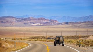
Then, for a few hours after filling up with fuel in Tonopah, it was wide open roads from nothing to nowhere.


Then, seemingly in the middle of an obscure oblivion, a hot spring. Not just a steaming hole in the desert, this one was at one time developed, and to this day seems to be a rather idyllic setting in which to enjoy the warm waters - if only it were a little closer to anything or anywhere. It was posted for No Trespassing, but with the gate unlocked, we couldn't help but to take a look.


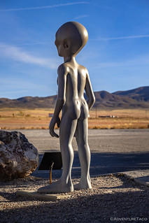
After a quick snack - those after-lunch naps can really suck the energy right out of you  - of apple and trail mix, we were back on the road and on the lookout for aliens. Or at least for their vehicles - our eyes scanning the sky for any glint or glimmer - as we were now traveling on NV-375, more commonly known as the Extraterrestrial Highway.
Unfortunately - though as usual - we'd forgotten our foil caps, so anything we spotted was easily erased from our brains by aliens over the next several hours.


Continuing west, we were now less than sixty miles - a bit of pavement and a lot of dirt - from the GPS coordinate that I'd gotten from some internet stranger. A plan surely destined for success. Continuing along NV-375, the nothingness of the nowheres was really starting to get to us - or at least to me - and as we passed through a Joshua Tree forest in a basin like all the rest, I pulled to the middle of the road to capture the moment.


Some large fraction of an hour later, we turned off onto dirt and headed south - only a little more than 30 miles from what internet strangers promised to be the perfect spot to observe the most secret of America's military might screaming overhead, mere feet off the ground. And that's when my "plan destined for success" ran into the brick wall of reality - or more to the point, the barbed wire fence of Area 51.
We were less than halfway there, and we could go no further.
So we did what any good adventurer might - we set up camp outside the gate and wondered if we'd see any high-speed chases - you know, American military might fighting the good fight against the enemy invaders.


In reality, we weren't really sure what to do. One the one hand, we weren't that far from my random internet waypoint - certainly not at speeds of 600mph that the jets might be flying. On the other hand... random internet waypoint.
It was a problem we'd need to solve in the morning, for now, we had chicken wraps to prepare before brushing our teeth, donning our tin foil caps, and crawling into bed.


More wonderful photos and quite a find at that mine, haven't seen such great mine artifacts in all my years. As for the manmade arch, remember the human saying, "why go around it when you can go through it!" Many years ago on one of our explorations near Calico Ghost Town, we discovered a quite long mine tunnel that went all the way through a mountain, coming out on the back side high above a valley, spectacular view. One caution is that half way through there was a bottomless (we couldn't see the bottom) shaft that had to be crossed on a 4x12, a bit sketchy. As for the solar generating station, I remember when they built it then nothing! Well before that there was a similar but smaller facility near Barstow, built for research and you could see it glowing from the highway. Actually, here just a mile from us there is/was a much smaller but similar research station, same concept, that operated intermittently, we could see it from our back yard glowing pure white heat. The buildings are still there but they disassembled the tower, mirrors, etc., a couple of years ago after completing their research project. I think it still has the company signs & warnings on the site and still has a security patrol. Maybe, in the future when we're all gone, a generation will wonder if that was an alien landing site, LOL.
I've heard of a tunnel near Calico, but never have researched enough to find it; your description - over the 4x12 - adds a bit of extra "adrenaline factor," doesn't it?
I suppose that with the power plants, it's always a good idea to be researching new ideas, but it sure would be nice if they all panned out the way they were originally planned... of if everyone had best intentions, rather than "selling a project" that they get paid for but is ultimately a failure. Who knows, maybe one day we'll harness the sun and geothermal in a way that really will provide worldwide power for reasonable costs. Then, we'll just need to figure out how to get to space on electricity! I mean, surely someone should have just copied Star Trek by now. 😉
I'm rapidly losing what little faith I had about anyone in government doing what is good for the people or country. If there isn't a buck for them in something they label it "FAKE NEWS" or "FAKE SCIENCE" and that's the end of it. Until there is a real, workable, way to save huge amounts of electric energy the solar stuff will be mostly worthless. If there were really looking for clean energy they be doing more with hydrogen and nuclear. Where is our biggest problem, probably water and energy and there are solutions just not the ones the politicians and their corporate masters want. As for the mine near Calico, it's up an unpaved road in one of the canyons but is a good road and even 2WD is no problem. But I'm not sure I could find it again.