
Even sheltered in the pinyon pines, the wind rocked the tent for hours - though in our sleep-deprived state, we barely noticed. Things calmed down significantly after midnight - enough that I removed my earplugs and continued to snooze soundly until my alarm went off at 5:45am.
If that seems early, let me explain. This trip - the winter solstice occurring smack in the middle - was one of very short days. With sunrise at 6:30am, and sunset at 4:30pm, our days would be full as we tried to fit in everything we wanted to do. Oh, and of course, I always love to capture that first colorful light over the horizon.
Given our sheltered site, the horizon was out of the question this morning - but that didn't mean I couldn't climb to higher ground and capture the sun as it reached into the little canyon in which we'd huddled through the night.


As I hopped around enjoying the long morning rays as they pierced the 28°F air, @mrs.turbodb whipped up breakfast - our cereal bowls cold enough to turn water into slush as soon as it hit the surface. We ate quickly and got the tent stowed - with a bit of frost still on the fly - before heading out of camp a little after 7:00am.

Retracing our way out of the Clark Mountains, we passed the Ivanpah Power Plant - its acres of mirrors still not harnessing any of the sun's energy, a big miss in our book - before crossing I-15 to enter the main body of the Mojave National Preserve via Nipton Rd. and the Ivanpah Valley.


We wouldn't see much pavement on this trip, and a gravel road would have been a much more pleasant drive than the few paved miles of Ivanpah Rd. that would deliver us to the New York Mountains. With disintegrating pavement that made us thankful for our aired down tires, we were glad to see the pavement ends sign as we crossed the tracks of the Union Pacific Railroad.

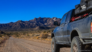
The New York Mountains are some of our favorite in the preserve. 25 miles long and reaching a height of 7,532 feet, they are the second highest in the preserve and receive more moisture than most places in the Mojave Desert. As a result, some of the thickest forests of pinyon pine, live oak, and juniper thrive in this rocky range, granite boulder fields and balanced rocks adding intrigue to any hike in the area. Of course, we are far from the first to discover the pull of this place - many miners before us leaving their mark, adding to the thrill of exploration even more.
Update: August 2023
The York Fire (wikipedia) (inciweb) has burned through the New York Mountains (and more than 93,000 acres), changing the landscape for our lifetimes. I visited again in December 2023, and the aftermath (part 1 | part 2) was stunning.

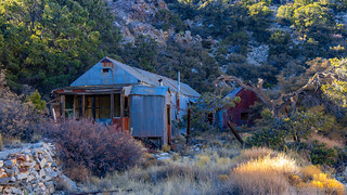
Ultimately, we'd explore three (!) of the New York Mountains' canyons this day, but we started out with one that we'd been looking forward to for some time - Live Oak Canyon. A two-mile trek from the trailhead at the wilderness boundary, we parked the Tacoma and set out up the old mining road towards the gem of this canyon - the remains of the Live Oak Mine.


Hiking here was easy - relatively - given that the route was obvious: follow the old mining road to its end at the Live Oak Camp. Sure, there were some steep sections, and we quickly shed layers as we pushed on - but our anticipation proved warranted as we arrived at our destination. There - smack in the middle of the road - an old photogenic pickup greeted us, a good indicator of what was to come.

We spent a good 45 minutes or more poking around the small site. An old bulldozer - used to grade the road, a cabin - its 55-gallon drum stove the only thing remaining inside, and the well-preserved ore bin complex giving us plenty to admire as we cooled down from the trek.

When we come across relics like this, we often wonder: why were these left behind? Didn’t they have value in their day? Never knowing the whole story, these questions will always be mysteries!


The highlight though, was the ore bin complex. From below, it looks like many that we've seen at various mines over the years - but from above, old narrow-gauge rails still curve elegantly across a trestle bridge, ending in mid-air - where material would drop down a chute and into the bin.

While the construction of this delightful structure was completed nearly a century ago - much of the timber weathered to deep oranges and black from the desert sun - it's clear that without the attention of more recent caretakers, it might no longer be so enjoyable for the rest of us. Within - I'd say - the last 5 years or so, someone spent a good amount of time on site, shoring up the rigging, expertly mating new with old. The joinery alone is worth inspection, true craftsmanship at work.

Skillful scarf joints, a respectful nod to the original craftsmanship of the structure.
The mine road we'd been following ended at the Live Oak Mine, no reason for it to continue further up the canyon - but we weren't quite done with our exploration. Less than a quarter mile beyond the end of the road and hidden behind a wooden door, we found a manmade tunnel that housed a distinctive spring - the slow dripping of water, audible, as we knelt down to peer inside the small opening.


Energized by our first canyon in the New York Mountains, we headed back the way we'd come - the downhill direction much less demanding than the experience coming up. From Live Oak Canyon, we didn't even make it back to the truck before taking a fork in the road - and wash - to an adjacent canyon, Keystone Canyon.
We were immediately greeted with the vestiges of those before us, a concrete water tank once likely used for livestock, now dry along the side of the wash.

Keystone Canyon too, like Live Oak before it, consisted of an old mining road that wound its way in and out of the wash as it climbed higher into the mountains - oak trees becoming the dominant species - as the pine and juniper faded away - their fruit plentiful for the local wildlife to enjoy.


Initially gradual, the grade of the road increased consistently until it'd be hard to picture a vehicle ever making the journey. Rounding the final bend before the Queen Mine, we found ourselves climbing through fields of boulders toward the tailings pile that marked the end of the road.

There, we checked out the old mine shaft - some nasty looking water keeping us outside rather than venturing in - as well as the concrete footings of the old mill used to extract the fluorite, chalcopyrite, and pyrite that were worked here.


Out of the relative warmth of the mountain, temps were cool enough to freeze the water before it could reach the wash.

As we turned to leave, we were once again reminded that old mine workings aren't the only reason we like to embark on these hikes. Now high up in the canyon, the views to the east through the Ivanpah Valley to the Castle Mountains were tremendous and we lingered a moment to soak them in despite the grumbling in our tummies after a second reasonably strenuous climb.

Hungry, we wasted no time getting back to the truck where @mrs.turbodb whipped up a couple of tuna sandwiches to go along with the chips and pear that we'd brought along for lunch. Our chairs setup in the sun and sheltered from the breeze that was once again starting to pick up, lunch hit the spot as we discussed our plan for the rest of the day.

A beautiful wash in which to eat lunch.
Our plan had been to drive from Keystone Canyon on the west side of the New York Mountains, to Caruthers Canyon on the south where we planned to camp for the night. However, in reading Hiking the Mojave Desert, @mrs.turbodb had discovered that there was one more canyon on the east side worth exploring: Sagamore Canyon.
Given that it was only a little after noon, and the description of what we could see, I quickly agreed that it would be a nice addition to our trip and we mapped out a route in Backcountry Navigator XE that we hoped would go through. The route included a section of road that we weren't sure was passable, but we figured was worth a try and would provide entertainment if nothing else:
Standard-clearance vehicles will have to stop at the steep wash crossing 0.3 mile past the spring. Beyond it, the road ascends a long steep grade. Most high-clearance vehicles will have to give up 0.5 mile past the wash crossing, where a deep erosional trench bisects the grade. At that point the road is too narrow to turn around, so park at the bottom and hike the rest of the way.
Obviously, we hoped to not park "at the bottom," which would add another couple miles to the on-foot portion of our Sagamore Canyon exploration. And so, with good line choice and our trusty rig, we made our way up this infrequently travelled road - getting a little flexy, but otherwise navigating the roads with relative ease - and only a little nail biting in the passenger seat.

Looks like nothing, but we were getting a little flexy.

Nearly 2:00pm when we disembarked the truck for the short hike into the canyon, we enjoyed the views from the toppled water tank before setting out towards one of the most well-preserved mining camps in the entire preserve.
August 2023 Update
The 2023 York Fire has burned through the lower sections of Sagamore Canyon and in the process Tin Camp was burned to the ground. The upper canyon was mostly untouched by the fire, but we've unfortunately lost this amazingly well-preserved mining camp.
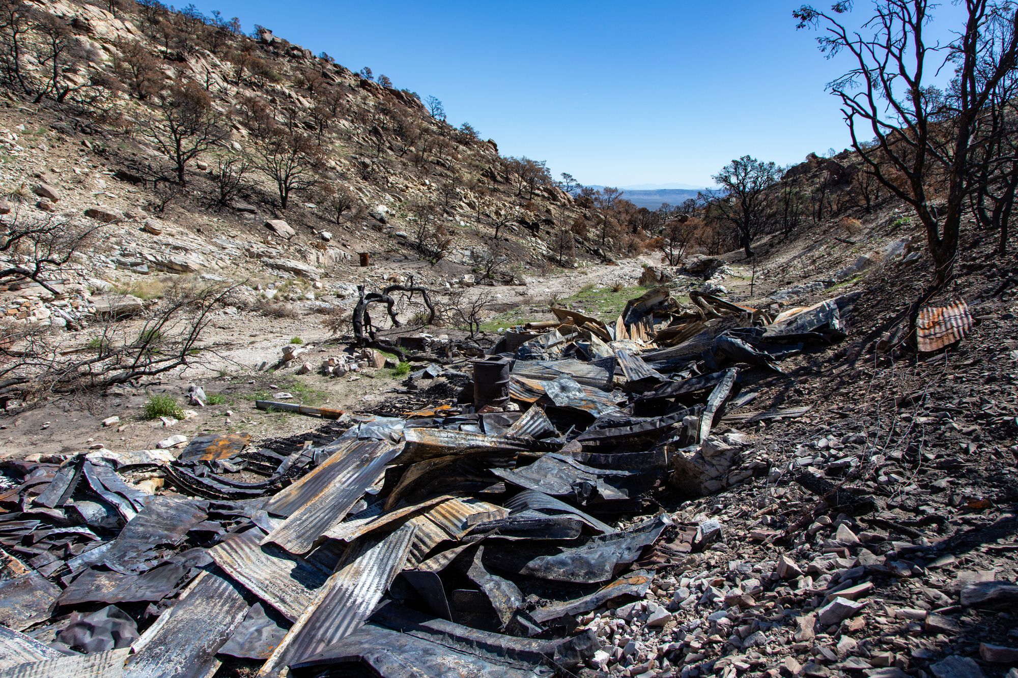
The remnants of Tin Camp after the York Fire. Photo credit: Guy Starbuck.

For us - having navigated the road further than most - Tin Camp was a mere six-tenths of a mile up the wash from where we'd parked. And, with the wash reasonably flat and gravelly at this point, we covered the distance in no time - Tin Camp's construction clearly influencing its current name.

Originally known as the New York Mine, Tin Camp was a small mine with modest production. And - as with many mines of the time - its history is best summed up by the phrase, "Early successes paved the way for future...failures." 
Silver was first discovered here in 1870 by Mormon pioneers who spotted narrow quartz veins laced with silver and feverishly extracted an unknown amount of high-grade ore. In August 1873, a 15-stamp mill was hauled in, but it proved to be ineffective and was shut down by May the following year. Over the next 20 years, Isaac C. Blake, a mining magnate from Denver ended up purchasing the mine to supply ore to the railroad he was building - the Nevada Southern Railway - which would travel from the town of Goffs to the promising gold fields of Vanderbilt. Predictably, neither the mine nor the railroad were financially feasible and by 1894, Blake was bankrupt and his assets repossessed by the bank. Hiking the Mojave Desert
As we explored the camp, vestiges of caretakers before us were apparent on the walls - even their writings and attempts at maintenance now in the distant past - none of the work less than 30 years old.

Welcome... sort of.

Tin Camp is now spartan, a few sticks of wood and instructions about using the barrel stove for heat, written on the wall.

The Ballroom.
From what was the bunk house, we continued across the wash to a strange building made of welded sheet metal - once perhaps a workshop used to maintain equipment in this harsh environment. Of particular interest - besides the construction - was the level to which the stairs of the building reached down into the wash. Apparently a good amount of water has lowered the height of the wash floor a couple feet since the stairs were poured.

Watch your step.

When we'd set out to explore Sagamore Canyon, Tin Camp had been the main attraction - after all, how could we pass up a group of such well-maintained structures. But, having reached the camp relatively quickly, we decided that continuing another half mile or so to the Alpha Lode Mine was easily in our wheelhouse - especially given that the wash was still mostly flat and easily navigable.

Historic irony. Often, the only part of a house standing after a fire: the chimney.

Tailings and ore chute of the Alpha Lode Mine.
Having now explored more of the canyon than we'd planned, it was time for a pow-wow. The obvious choice was to head back down to the Tacoma, and make our way to Caruthers Canyon - our original plan. But - at least when we are involved - smart money is rarely on the obvious choice, especially when the alternative is exploring something unknown or unplanned.
So, with the option to continue up-canyon another mile - in order to reach a ridge that formed the divide between Sagamore, Keystone, and Caruthers Canyons - we made the decision to ditch our plans for Caruthers Canyon entirely and continue on!

It was - we both agree - one of the best decisions we made all trip! In fact, we'd hoped to reach this same spot via Caruthers Canyon, but I'm not sure we'd have been able to do so - and definitely not as quickly as we were able to from Sagamore. Not that the mile was an easy one - far from it - the wash quickly narrowing, becoming steeper, and overgrown before we bailed up the side of the ridge in order to reach the divide.
But the views. Staggering.

Keystone (left), Sagamore (center), Caruthers (right) Canyons from a single viewpoint.

Keystone Canyon.

Caruthers Canyon.

Caruthers Canyon.
Our decision to explore - of course and as usual - had side effects. Notably, it took us quite a bit longer to navigate that last mile to the top than we'd expected, and by the time we were there, the sun was already setting over the highest peaks of the New York Mountains to our west. It was only 3:52pm in the afternoon, but we needed to make tracks if we were going to make it back to the truck before dark.
We stopped only twice on the way down - once to snap a quick photo of one of the coolest rock inclusions we've come across - and the second time to capture the moon as it rose up into the evening sky.


Back at the Tacoma one hour later - and 20 minutes after sunset - our faces were covered in the big grins of a good time, the detour to Sagamore Canyon being even more enjoyable than either of us ever expected. Still in need of a camp site, and knowing it'd be dark by the time we arrived, we decided that we'd still try to sleep at the head of Caruthers Canyon - if for no other reason than to enjoy the sunrise there in the morning.
A final distraction - one of the largest mine shafts and steel doors we've come across in the Mojave - was the only thing standing in our way.

From that point on, the drive to Caruthers Canyon was uneventful. Nearly pitch dark when we arrived, the wind had picked up again and we oriented the truck to shield us as much as possible as we made dinner, before repositioning it to reduce wind noise on the RTT when we climbed into bed.
Even after eating and reading for a few hours, it was early - surely before 9:00pm - when we called it a night. Our day had been a great reinforcement in the ability to be flexible as opportunities present themselves.
...and that would continue into the following day - because sometimes, often times, the unexpected can be the most enjoyable.


Great write up and excellent photos. This makes me want to get back out there and explore some more.