
There aren't many nights that I close up all the windows and doors on my tent, as - especially when there is a full moon as there was on this night - I enjoy being able to gaze out on the surroundings if I wake up in the middle of the night.
But parked under the watchful gaze of Easter Island Rock, with temperatures in the my-feet-are-numb range and a 10mph breeze blowing through camp, I zipped everything up tight, inserted my earplugs, and hoped for the best.
It worked, and I was nice and toasty when my alarm - now explicitly set to real time, and not stuck on whatever weird time Arizona uses - gently woke me at 6:05am, about 20 minutes before sunrise.


Climbing from one boulder to another, I tried to be quiet but either Mike @Digiratus and Zane @Speedytech7 had set their alarms for a similar time or I failed in my noise abatement attempt. And so, as the sun peaked over the eastern wall of the canyon, we all began our morning rituals - Mike making coffee, Zane tearing down camp, and me - still futzing around with the camera.


Carruthers Canyon has always been my favorite place in the Preserve, but with all the damage from the York fire, I found myself wondering if I will favor other desert places, rather than be reminded of what once was in this special canyon.
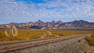
Soon though, I had other - more immediate - matters on my mind. Headed east across the Lanfair Valley, we were surrounded by alien Joshua Trees and the Castle Mountains - their escarpments scared by strip mining - rose in the distance.

Castle Mountain is an open-pit heap leach gold mine that produced more than 1.2 million ounces of gold from 1991 to 2004, at which point the mine was closed due to low gold prices.
Equinox Gold acquired the mine in December 2017 and completed a feasibility study in 2018 with the intention of restarting operations. The study outlined a two-phase development plan, with annual average gold production of approximately 30,000 ounces during Phase 1 using existing operating permits, and a Phase 2 expansion to more than 200,000 ounces of gold per year.
Phase 1 activities began in October 2019 and commercial production was achieved in November 2020. Primarily using stockpiled ore from previous operations, this phase is - essentially - a small-scale pilot plant for the planned Phase 2 expansion.
Production at Castle Mountain in 2023 is forecast at 25,000 to 30,000 ounces of gold with all-in sustaining costs between $1,865 to $1,950 per ounce.
Equinox Gold(AdventureTaco Note: gold prices as of this writing are in the $1,950 oz range, so this isn't a very profitable mine.)
As we crossed the valley, the road passed by pile of volcanic rocks with a deep desert varnish. The perfect spot for some rock art, my right foot quickly moved to the brake as I pulled the Tacoma out of gear and grabbed @mrs.turbodb's binoculars from the rear seat.
Usually in situations like this - or I suppose I should say "always," before this particular incident - there's nothing to see. This time, however, I hit the jackpot!


For the second time in fewer than four hours, I found myself bouldering through the desert, this time being careful to avoid the plentiful petroglyphs. We were there for a good 15 minutes or so - long enough for Mike to excuse himself for a little seat time on his Lug-a-Loo - before wrapping up our investigation and beginning our ascent into the Castle Mountains.

As we reached the base of the mountains, I turned left, hoping the road would lead us to the ruins of the Valley View Mine that I'd seen in satellite imagery as I researched the route. Within a quarter mile, it was clear that this was not a road that would get us there, but as we endeavored to turn around, Mike's truck stalled and wouldn't restart.
Immediately, it was Zane-to-the-rescue. To be clear, this is always the case whenever anyone has a truck problem and Zane is along, but in this particular situation, it was extra nice to have him there because the problem seemed to be with an aftermarket ECU (the computer that controls the whole Tacoma) that Mike and Zane had installed over the course of the last year.
Laptop in hand, Zane hooked up to the ECU and began debugging. Figuring that it might be a minute, I set out to explore the maze of roads - leading to dozens of historic mines sprinkled amongst the mountainous terrain - to find the one that would carry us to the mine we were after.

After rolling back the latest update to Mike's snazzy new computer, the Redhead - that's Mike's truck - fired up and Zane declared the problem "fixed enough." We were back underway.


By now, Mike wasn't just worried about his truck, but he was also in need of fuel. We'd covered a bit more than 150 miles since he and Zane had gassed up in Mojave Valley, and with a 6,000lb supercharged beast, he was getting on the order of 10 mpg through the rough terrain.
As I think is only natural, Zane and I (minus Zane, who's not a total jerk) decided that low fuel was his problem and that we should continue as though nothing were amiss and that we all had tanks that were half full. Because, Zane (for real this time) and my tanks actually were half full.
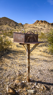
Which is when we stumbled on the first EMHT Mailbox.

After a quick stop for lunch as we overlooked the Piute Valley, we made the 10-mile run to Searchlight without further issue. It was there - after filling up with gas - that things would really get interesting.
After playing with Mike's computer a bit more, Zane determined that it was sporadically sending the 5VZFE engine into a lean state (not enough fuel). In this state, Zane wasn't comfortable with Mike continuing, but after a bit more investigation, it seemed that the lean state was the computer reacting to what it sensed was a rich state (too much fuel). Suspecting a spark plug or ignition coil, we tore into the engine to inspect - and regap if necessary - the plugs.

Ultimately, the plugs looked bad - but still, good enough - and Zane decided that next step should be rolling back the latest firmware update that he'd recently installed into Mike's ECU.

After rolling back, things were immediately back to normal for the Redhead. This, I assure you, relieved all of us. None of us mentioned it at the time - we're too superstitious for that - but the thought that we might have to call the trip after just a single day was not something we were keen to entertain.
And with that, we headed back into the desert, and into the eastern edge of the York fire.

A few hours later - having worked our way into the northern tip of the New York Mountains - we crested the pass and began our descent towards the old town of Nipton. First though, we took a minute to "admire" of the sun-worshiping towers of the Ivanpah Solar Power Plant.

 are those?"
Built between 2010-2014, the Ivanpah Power Station is a solar thermal power plant that uses nearly 175,000 mirrors to focus sunlight on three boiler towers to generate steam and power special turbines that generate electricity. Capable of producing 392 megawatts, it was built on public land as a joint project between California and the U.S. Government - at a cost of $2.2 billion. Ironically, despite being a solar thermal plant, it burns natural gas for several hours each morning to warm up the boiler towers, emitting nearly twice the pollution that California allows for power plants and factories.
And, to add insult to injury, in September 2016, federal biologists reported that approximately 6,000 birds die annually from collisions with the towers or by immolation (being burned) while chasing flying insects through the superheated air reflected by the mirrors.


After a bit of admiration-turned-bewilderment, we headed into the Ivanpah valley toward Nipton. I'd related Nipton as an "artsy little town," since that's how @mrs.turbodb and I had found it as we passed through on the Nevada Backcountry Discovery Route (NVBDR), but it turned out to be nothing of the sort this time. All the art - and frankly, color - was gone from this historic little town, and we almost passed through without stopping at all. Only as we were pulling away did I notice the rocky crags of Castle Peaks in the New York Mountains to our south, and after a quick photo, we were gone.
Note: I am easily confused.
It was 4:25pm as we reached the base of the Ivanpah Valley. With less than 30 minutes until sunset, we wrapped up Segment 1 of the EMHT at the old Ivanpah Con Mill at the base of the Clark Mountains. There's little worth seeing there today, and anyway, I had my sights set on a camp that I knew Mike and Zane would enjoy - if only we could get there before the sun dropped below the horizon.
Sunglasses on - and windshield visors lowered - to battle the blinding sun, we climbed the steep road toward the Coloseum Mine. We wouldn't visit the mine till morning, but even from the road, this place is imposing. Cresting the saddle I voiced relief over the CB Radio when we finally turned south - into the Shadow of Clark Mountain - and we were able to remove our sunglasses and see again!

As we pulled into camp, it was smiles all around. Plenty of flat space - both on the edge for Zane and me, and a little further away for Mike; a fire ring, that we'd forego in favor of propane. but nice nonetheless; views - all around - that we could enjoy as we chatted into the darkness; and no wind.

It'd been another long day, and with the real possibility of it being the last, we lasted only an hour or two after moonrise. Then, the call of soft, horizontal surfaces was too much to bear - at least for Zane and me - and we were off to one of the most pleasant nights of sleep of the entire adventure.
The next day, we'd head west. To places none of us had ever travelled. On roads that no longer exist. At speeds so slow, we might as well have walked.
The Whole Story


Looking for other segments of the EMHT? Check out
East Mojave Heritage Trail
for other trips where the other parts of this epic route were enjoyed.
Great narrative, as usual. I plan to do the EMHT soon. Are you following the guidebooks, or just the route track?
Thanks Tim, is a fun route - but a long one. I thought we'd be able to do most of it in a week and I was mistaken. I think 9-10 days is probably the minimum at this time of year (short days), unless you're just driving straight through and not looking at anything/stopping at all along the way.
I'm just using the route for the EMHT itself, but I have a lot of other resources that I used to suppliment what/where we stop and see. These resources fall into three categories:
And of course, once I get back, I always end up doing a bit more research as I'm writing the stories, since I stumble on various mines, etc. that I'd like to include a bit of history about, but that I didn't know prior to setting out.
Hope that helps!
I have all four of the books, and the supplements. There is much to see, that you might otherwise miss, and lots of history is contained in them.
Yes, the history is something I think I'd enjoy. The "things to see" - well, I've already added so much to the route ("Extras" I call them in my KML) that I'm at risk of turning it into a multi-month excursion.
I actually find that for routes like this, I rather enjoy staying (reasonably) close to the route, and then returning for another trip for things that are a bit further away.
That said, I wouldn't mind seeing the guidebooks someday, so I could read the history. That was the most interesting part of the Gold Road to La Paz, An Interpretive Guide to the Bradshaw Trail book for me.
I like the Bradshaw Trail book and think it's very good. Last year, when we were visiting Red Rock Canyon State Park (CA) and Jawbone Canyon I picked up another book that I like, Guide to California Backroads & 4-Wheel-Drive Trails, it has some good info and many maps and photos plus ratings of trail difficulty.
Those Funtreks books are great from the perspective of getting out in a vehicle. Personally, I wish they had a bit more history of the area, or hikes along the way or something besides just driving. Perhaps even better - now that I'm actually thinking about it - would be a supplement or companion volume that had all the non-driving info. That way, if you are just interested in driving (not to say you in particular are, John, but I know a lot of my buddies who would only be into the driving), then you could get the one book, and if you wanted "what to do there, and what *there* used to be," you could get both.
Anyway, there I go complaining when I suppose I could be doing something about it. If I wanted to divulge specific directions to places, and was a more compelling history writer, I suppose. 😉
Great post guys! Thanks for the reminder about "The Gold Road to La Paz!" I was on the book signing tour that Saturday with Delmer Ross, the author. I gave a CB guided tour of the actual trail, in its entirety a few weeks later. Good memories.
Wow, that's super cool to have been "at the front door" of that book (and trail!), as it were. Since running it back then, have you ever returned? I'm curious how you've noticed it change over the years, if you have.
So you know, this is the favorite trail of one of my buddies, so I'm sure he'd be extremely jealous (in a good way, of course) of your association with it, and he'd probably love to hear your stories even more than I would.
Also, I have to say - it's these types of "connections" or memories that come out as a result of me writing/posting a story that are one of - if not the - the most enjoyable things for me. Hearing from others who (a) usually/always know more than I do and (b) have memories - usually good - that are jogged as part of reading the story, makes me think about stories I'd hear from my grandfather about his adventures, or about memories I have of places that other people post stories about, and the joy that brings me.