
Our night below the The Hunchback couldn't have been more pleasant. Though we were at 10,500-feet, temperatures never dropped below the mid-40s °F, and even getting up for a bathroom break and some less-than-mediocre star photos was an enjoyable few minutes.
Unlike the previous morning when I hadn't set my alarm, I made sure I was out of the tent a little before sunrise to capture that magical time when the sky is transitioning from dark to light and the earth's surface is shadowless. Here, with views of the Sierra all around, it was spectacular.


Also unlike the previous morning, there was no climbing back into bed - with 11 hours of horizontal time, there was no need. Instead, after running around frantically for a few minutes as the light changed, I whistled to @mrs.turbodb and beckoned her down the ladder - it was time to hike!
In fact, I'd been looking forward to summiting The Hunchback since we'd arrived the previous evening, and while I think the lady could have been happy with a bit more sleep, it wasn't long before we were working out the best route to the top.

After contemplating a more direct - but steep and rocky - route to the top of The Hunchback, we'd ultimately made the smart choice to follow a slightly longer-but-gentler grade. Even so, the mile-long climb from 11,500 to 12,148 feet took us less than half an hour and suddenly we were on top of the world.
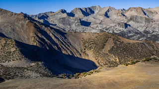


The Hunchback - as its name suggests - is more of a ridge, with a few prominences that vie for the title of "highest point." Naturally, from each one, the others look just slightly higher, and so we made our way to each one, just to be sure that we could ensure victory in reaching the top.


After spending longer at the top than it'd taken to get there, it was eventually time to head back down and get underway, so I too retraced my steps to the first prominence before heading back down to the Tacoma so we could stow the tent and hit the trail.


Even with our early start to the day - sunrise was at 7:00am - it was only a little before 10:00am when we finally pulled out of camp. Trail mix in our bellies, the tent stowed, and pants traded for shorts in what was turning out to be another extremely pleasant day, it was time to go investigate a remote "cabin" I'd spotted on the map when I'd planned out the route through this mountainous terrain.


Tracing our route back a few miles to the turn off toward the cabin, we eventually found ourselves behind an UTV with two fully-camo-clad hunters out enjoying themselves as they scouted for deer. Oblivious to our presence behind them, we tootled along for a half mile or so before I stopped for some photos - hoping that they'd bypass our turn and continue down the mountain.
Naturally though, they were going the same way we were.
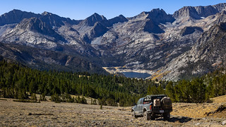
Snapping a few extra photos and soaking in the views of South Lake in the distance, I dillied and dallied as much as I could before noticing that they too were stopped in the road about a quarter mile ahead - one of the guys now under the UTV looking at something.
Figuring that we would either be able to help out or pass if there wasn't any real problem, we rolled up to the guys and got out to say hello. They turned out to be super nice - glad that we'd stopped to offer help, but assuring us that they were just fine. In the course of the next few minutes, we also discovered that they'd seen us up on the top of The Hunchback through their binoculars, and they informed us that the "cabin" we were planning to visit was actually an old mine structure (from what I would later discover was the Lindner Mine).
Thankful for the pleasant interaction, we bid them a great day as we hopped in front of them on the trail.


In the end, the mine site wasn't all that interesting - all of it just a little too far gone to really answer any questions about how big the operation had been or what they'd been up to. Still, as we followed the diggings and tailings piles to the ridge, we were greeted with a very nice surprise - a colorful fall view of the Sierra, all the way down to the canyon floor.

While we were poking around the mine site, we'd noticed the hunters continue further down the road. Figuring that they knew better than we did, it seemed like a good bet to head the same direction - after all, we were already all the way out here! Sure enough, a couple miles later, we found them enjoying similar views to those we'd reveled in just moments before.

Knowing that we'd have another fun conversation, we worked out way out to the edge of the ridge and spent half an hour or more chatting with these guys. In their late fifties, they'd been hunting the eastern Sierra for decades, but had only been in this area for the last few years. South Lake - amongst others - they said, was lower than they'd ever seen it, and we shared stories - and a strong distaste - of the route to Funnel Lake.
"I don't know why it's so popular," @mrs.turbodb said. "It seemed like torture to get there and it wasn't even that nice once we were there."
"It's on the YouTube," was their reply.
Eventually, we decided to eat lunch, and they decided to continue on their way - enjoying the same clean air we were - and we bid them farewell as tuna sandwiches were assembled and chips were consumed. Soon enough, we'd taken their place, as we filled out bellies with food and our eyes with views for a few more minutes before continuing on our way as well.


We had one more spot to explore - prior to heading down toward Bishop - and that meant backtracking a bit towards the main route in Coyote Flat. Along the way, we noted how similar the road and terrain felt to Railroad Ridge - the highest road in Idaho - and noted that we were significantly higher here, at 11,367-feet above sea level. Not the highest publicly-accessible road in California, but dang close.
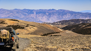

After a brief drop to 10,000 feet, we climbed back up Lookout Mountain - where there is, unfortunately, no lookout - to a spectacular view of Coyote Flat and the mostly-rubble Sugarloaf Mountain. Then, it was back down the west side where we'd follow the road to its end, curious for what we'd find.


It's at this point that I should admit that our curiosity of "what we'd find" may have been a little more of expectation than wonder. While I hadn't planned to explore Lookout Mountain (also, apparently known as Discovery Mountain) beyond the overlook, I had noticed that there was significant mining activity further down the road. And, when we'd talked to the hunters - who happened to have setup camp at the head of the Lookout Mountain road - they mentioned a miners cabin in this location, thinking it was the cabin we'd visited the previous day. Of course, we knew that meant there was another cabin, so we were excited to check it out.


There wasn't much left of the Schoden Mine - just the cabin - but we made up our own stories of an initial strike and the inevitable bust that likely followed as we wandered the site. Most amazing - as always - was the determination that the miners embodied. To build a road, haul supplies, mine the land, and eventually eek out a few ounces of gold... wow.

Schoden Mine - Discovery Mountain.

We'd dropped nearly 3000' as we'd descended to the mine, so after exploring for a few minutes, we made our way back up and over Lookout Mountain to re-join the Coyote Flat route that most folks experience when visiting this place - the northern access, via Bishop.
As expected, the northern route was slightly longer, but certainly easier and significantly more travelled. A dusty, two-lane thoroughfare for much of the route, it dropped down the northern face of whatever these almost-but-not-quite-Sierra-mountains were that make up the gateway to Coyote Flat, providing some nice eye candy along the way.


At this point it was still relatively early in the day - just before 3:00pm - but we decided that the best course of action was to head camp. Our hope was that its location - a couple thousand feet higher - would be a bit cooler and set us up well for a hike that I hoped would be the highlight of the entire trip.
That is, if we could muster the energy for a 14-19 mile roundtrip, climbing from 8,000 to 12,000 feet. But as usual, I'm getting ahead of myself...
For now, we covered a few quick miles on CA-168 before turning onto dirt and navigating the lesser-traveled backroads to the Buttermilk area. Initially bumpy and unpleasant, these roads eventually turned out to be fantastic, first skirting a ridge next to an enormous water pipe before winding through some brilliant yellow aspen groves in the late afternoon sun.


We reached the end of the road and the trailhead to Horton Lakes right around 4:30pm. To our surprise - having seen almost no one else this entire time - another Tacoma was parked in the road, it's passengers nowhere to be seen (obviously, they were on the trail).
Wondering whether they planned to return and spend the night (we didn't want to intrude), we hung out for a few minutes, pondering what to do. Fortunately, only a few minutes later, voices carried down from higher on the trail as the three hikers returned from their adventure. Having left at 6:00am, they'd "made it to the top," had a great time, and weren't planning to spend the night - all music to our ears.
Well, except for the 6:00am part. We'd planned to leave a bit later than that - but they seemed quite a bit younger and in a bit better shape. Perhaps we'd need to rethink our plans...
Whatever.
A few minutes later we had the place to ourselves, and set about our usual evening routing. Tent, dinner, washing up, that kind of thing - all as the sun first dropped behind the Sierra, and eventually below the horizon. As usual, it was as good as any show on TV.
Almost.


Knowing that we had a huge day in front of us, we hit the sack early. There'd be no getting up for star photos, or even staying up late enough to snap a shot of a moonlit landscape. No, we needed our rest.
Tomorrow, we planned to hike 14 miles. To climb from 8,000' to 12,000'. To explore old mining camps and roads. To have a fantastic time.
If, that is, our lungs could bear it.


Hunchback not Huntchback Mtn! Several times repeated!
Thanks! At least I was consistent, ehh? ? I've updated them all and appreciate the correction.
Another interesting adventure with spectacular scenery, thanks again for sharing.
You’re making me want to head back to the Flat, of course there’s so much to explore there- it’s always on my mind. I truly appreciate the amount of on the ground foot time the two of you spend, also your knowledge of natural and cultural history, not to mention the amount of time you spend in SoCal- quite a drive to our deserts from your base. I’m inspired to follow your sense of wanderlust.
It' All Too Much!... Will my rear locker Tacoma Make this Trail? Looks like the elevation changes might be a little hairy. Crow fly miles look like 12 miles, Is 20-25 more like it to Coyote Flat from Bishop? (I'm looking at Google Earth Pro for my details).