
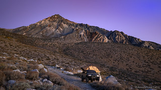
We awoke on the third morning of our trip, full of anticipation. Or at least, full of something that starts with an "a." Perhaps apprehension.  Whatever it was, we knew we needed to get an early start on our day, and so were down the ladder before the sun rose above the horizon.
 (windshield)
We'd gotten a good night sleep, and as @mrs.turbodb set about assembling tuna sandwiches and other lunch fixings, I stowed the tent in case there were others who visited the trailhead during the day. No need to air our dirty sheets while we were out on the trail.

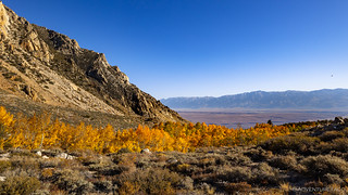
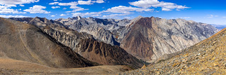
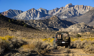
We'd hoped to leave by 7:00am - anticipating between 7- and 11-hours for the day's hike - and we nearly hit that; starting out of camp and passing a sign that indicated our entrance into the John Muir Wilderness just a little after 7:20am. Immediately the trail began its climb, a series of reasonably gentle switchbacks - one a mining road - working their way up the alluvial fan.

The hike we were on - first to Horton Lakes and then to the Tungstar and Hanging Valley Mines - was one that I've been looking forward to for a while. I don't remember exactly how I discovered it, but I hoped that the trek - 7-9 miles and 3,500-4000' one direction - was worth it, especially since I'd sold it as totally amazing to @mrs.turbodb.
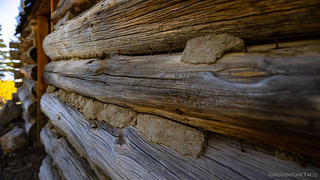
The idea - as far I knew - was that we'd get about four miles into the hike before reaching Horton Lake, which also happened to be the location of the mining camp for the Hanging Valley Mine. So, you can imagine my surprise when - after just 40 minutes of hiking - we happened on a meadow with a couple of old mining cabins.
In fact, not expecting the cabins at all, we were initially just enthralled by the fall aspen, and it was only after pulling our memory capture devices that we noticed the structures.
"Oh, these are the cabins," I exclaimed!
They weren't. We might be reasonable hikers, but we do not cover 4 miles and 2,000 vertical feet in 40 minutes.


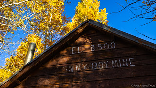
I think my hiking partner realized almost immediately that these were not the cabins we were expecting, but it took me several more minutes - in fact, we may have already gotten back on the trail - before I realized that these were cabins I'd not known about prior to stumbling on them. Still, we had a good time poking around the Sonny Boy Prospect, wondering - as we often do - as to the success of the operation.


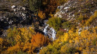
After poking around a bit, @mrs.turbodb was the one to hustle me onward. She realized that in a sea of yellow and orange, I could end up stopping for hours to take pictures of the fall colors, and that we needed to keep moving if we were ever going to get to the top. She was right, of course.
Still, as we continued up, I couldn't help but to stop for a photo or two. Luckily, I'd brought more than one battery for the camera.


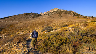
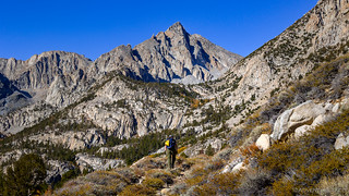
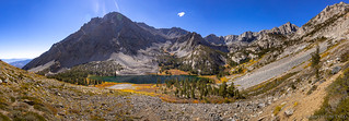
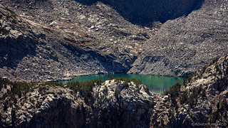
It took us another couple of hours to cover the ground between the Sonny Boy Prospect and the Hanging Valley Mine Camp at Horton Lake. This part of the hike skirted along the southern flank of Mt. Tom, climbing consistently for 3 miles and 1,500 feet. With the morning sun at our backs, we took a few breaks here and there, but largely kept up a consistent pace until we reached the short side trail to the cabins I'd expected to find along the route.

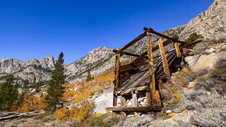


The Hanging Valley Mine was established in 1939 by Mijo "Mike" Milovich, a native of Yugoslavia after discovering some garnet-rich material in a broad, plateau-like valley on the western shoulder of Mt. Tom. To shorten the distance to work each morning - at least, during the summer months when the mine was worked - he also built two log cabins near Horton Lakes. And, even though it was only 10:00am, it seemed like this would be the perfect location to have lunch before we made the final - long - climb from the mine camp to the mine itself, some 2,000 feet higher.


Lunch was a leisurely affair - perhaps more-so than it should have been - as it was still early in the day, but by 10:45am, and after another couple trail-jogged into the mining camp, we were once again on our way. The going would be tougher now - the trail steeper and the air thinner. Still, we certainly had it easier than Milovich, who was crazy enough to build this road to the sky.
In 1940, Milovich improved a crude trail up Horton Creek and packed out a 50-ton sample of the rock for a mill test. The results were encouraging which prompted Milovich to spend the next five years constructing a five-mile road to the 11,700 foot site.
The biggest challenge was completing the last 14 swithbacks up the steep 2,000 foot-high escarpment between Horton Lakes and Hanging Valley. It was slow going as most of the work was done by hand with the aid of a small dozer. Ring bolts were placed in the bedrock and the dozer attached by cable for safety should it come too close to the road edge. Once completed, some of the switchbacks were so tight that vehicles had to back up between them on the climb up to Hanging Valley. owensvalleyhistory.com


In the early 1940's, Milovich's two sons, Ray and Bob, did most of the ore hauling, hauling 20 to 30 tons per day, down the narrow slope using a dozer and a specially designed trailer that could negotiate the tight switchbacks. It was then transferred to dump trucks for the haul to [Bishop]. owensvalleyhistory.com
Those boys were crazy.
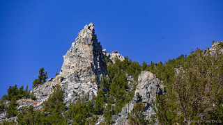
Switchback after switchback, we slowly - and I mean slowly - made our way up. With the air thinning, frequent stops "for photos" or to "soak it all in" became commonplace. As we rounded each of the 14 switchbacks, we'd count them off - happy for number 8, but eager for number 14, our lungs straining for air.


As we rounded switchback 11, an old juniper tree - likely just a seedling when the road was built - happened to provide plentiful shade over a series of large boulders that'd been arranged at the apex of the turn to prevent vehicles from careening over the edge. It was here that @mrs.turbodb urged me to continue on, knowing that I'd likely spend more time exploring the mines at the top than she would, and so executing the last few switchbacks separately wouldn't be that big of a deal.
These, it turns out, were poorly laid plans.
Anyway, without giving it too much thought - which I'll contribute to the thin air - I continued on. Perhaps even increasing my pace, I hoped that I could visit the Tungstar Mine - the higher of the two - before she even reached the point at which the trail forked at saddle along the top of the ridge.


At this point, I was cognizant of the fact that @mrs.turbodb and I had no way to communicate when she got to the top. I kicked myself for not bringing my handheld GMRS radios, or for at least giving her the handheld Ham radio that I'd brought along for emergencies (not that a single ham HT would have done any good, except to give her a possible way to contact help).
Hustling, I made good time to the Tungstar, covering the two miles in just under 25 minutes - not my fastest walk, but not too shabby for 12,000'. And boy, as I caught my breath, was I in for a treat!


As the name implies, the Tungstar Mine was developed to exploit tungsten buried within the talus slopes of Mt. Tom.
Discovered in 1937 by Yugoslav immigrant Bill Wasso, it was sold a year later to a group of investors from Hollywood, who were gambling on the potential of a prosperous tungsten market. These included Reginald Owen, Walter Abel, Shirley Temple (only 10 years old at the time), and Randolph Scott. This movie star connection provided the basis for the mine's name, "Tungstar."-owensvalleyhistory.com

It became apparent to the developers that an aerial tramway was the only feasible method for getting the ore down off Mount Tom and to the nearest road. The road was located in Pine Creek Canyon, 4,500 vertical feet lower and 2.5 miles away. In 1939 the R.N. Riblet Tramway Company designed and built a system over terrain that was a challenge to the most intrepid of engineers.
Over 13,700 feet long and $165,000 to build, it worked, but could only transport 40 tons of material a day - not enough to keep the mill running full-time. Additionally, the all-metal towers were too low to operate during winter months - when snow depths reached 60-100 feet - and the tramway was prone to cable breaks.
A new tramway, finished in the fall of 1942, had 16 towers with a tension station near the midpoint. The longest span was a 2,000-foot stretch suspended 500 feet over Gable Creek gorge. The tram cost an additional $135,000 to build, but could transport 100 tons in an eight-hour shift. It was mostly gravity operated, with the weight of the loaded buckets going downhill pulling the empties back up.-owensvalleyhistory.com


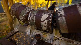
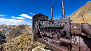
Unfortunately I didn't have time to hike a mile - and 1,500 feet - down the mountain to check out a few of the tram towers that still exist, but I did get to admire the two enormous diesel generators that were once charged the tanks that powered the air drills used for extracting ore.


My quick - probably only 15 minute - exploration complete, I once again found myself hurrying along the Tungstar Mine road. Luckily, I was going downhill this time, so I wasn't quite so winded as i made my way to the saddle where I hoped to reacquire my hiking companion.
About a quarter of the way back, I saw a small dark spec in the distance. Moving towards the saddle from the Hanging Valley Mine, I knew it had to be @mrs.turbodb. I yelled. I yelled again. No response. I picked up the pace.
My return trip - half jogging - took only 20 minutes, a good thing given the understandably worried state of @mrs.turbodb, since she couldn't find me upon reaching the top. Luckily, a hug - and quick recounting of each of our stories - after we met back up was enough to set her at ease again,

Having been there for 20 minutes or so, she had already walked over to the Hanging Valley Mine, but humored me in checking it out again, knowing that I wouldn't want to miss it after coming all this way.


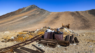
Reconnected, we wandered around at a bit more leisurely pace than I'd explored the Tungstar Mine, visiting each of the Hanging Valley Mine's three levels, wondering what it'd been like to perform hard labor at such extreme elevations.
As always seems to be the case, we each had our favorite aspects of the mine. Personally, I was excited for the ore cart that had jumped its tracks and was now "racing" down the road. Obviously, there was only one thing to be done.


@mrs.turbodb's favorite element also turned out to be mine carts, but these were missing their trucks (wheel assemblies). Placed next to the tracks above one of the ore chutes, it was almost as if they'd been used as tubs. Laughing, she assured me that we could strike a recognizable pose.
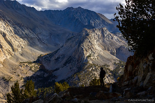
Our exploration of the mines complete, we started back down the mountain just after 3:00pm. Since we'd left, the sun had travelled most of the way through its arc and made for some gorgeous lighting conditions as we traversed the switchbacks and worked our way through the fiery aspen.


We didn't stop much on the way back down. Descending 4,000 feet in just 2½ hours - more than three times the pace of our ascent earlier in the day - we'd taken a metric ton of Ibuprofen before heading down, hoping to save our knees (or at least mask the pain) until we'd reached the bottom.
We could have given the trail joggers - who never made it to the top by the way - a run for their money.


The sky was just beginning to change color as we passed by the Sonny Boy Prospect cabins, a purple hue following the shadows of the Sierra as they crept eastward across the valley. We had one mile to go.

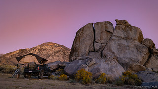
We reached the Tacoma at 6:00pm, almost exactly 11 hours after setting out in the morning. Parked at the trailhead, we'd spent a good portion of the last mile discussing where we should camp. On the one hand, it would be extremely easy to redeploy camp without moving at all. On the other hand, Buttermilk Boulders was only a few miles away, and offered a location we'd never visited, and the opportunity for something a little different.
Ultimately, we opted to give Buttermilk Boulders a try, hoping that we'd be able to find a spot at this relatively late hour on a Saturday evening.
A smaller version of Alabama Hills, the boulders were hopping when we pulled in. We counted no fewer than 24 vehicles, and the humans crawling over the rocks were like ants scavenging for food. Luckily, we were able to drive around for a bit and found a more secluded spot away from the action. With our fingers crossed that no one else would venture this way, we donned our head lamps and set to work with the nights tasks.

Earplugs in - there were plenty of late arrivals to the general area, exhausts blaring along the main road a half mile away - and bodies tired, we got the best night of sleep we'd had all trip.

In no big rush, we took our time putting everything away and getting ready for our long journey home. We weren't quite done with the planned activities for this trip, but with 1,000 miles of pavement to pound, it's always nice to clean up the inevitable mess of clothes strewn in the back of the cab, and get everything stowed away in preparation for the next adventure.
And with that, we knew that - like Alabama Hills - we'd probably never camp here again, the proximity to Bishop turning a beautiful place into a parking lot. Oh well.
As we headed north on US-395, we had one more trail to run before we aired up and made extensive use of the skinny pedal. It was a trail that I'd gotten wind of nearly two years before; a trail that had been closed for much of that time; a trail I wasn't sure was passable, even now.
One way or another, we'd find out soon enough.


Do you know if the Toms Cabins resort near Mammoth is named after Mt. Tom?
Hey Joe, I don't know for 100% certainty, but I think they are not named for the same person. Here's what I found with a little sleuthing:
Toms Place
Mt. Tom
I don’t think the proximity to Bishop is the reason for the overcrowding at Bama Hills and Buttermilk. It’s the proximity to Southern Cal.
Once again, the masses ruin it for everyone. And I wish the ego trippers who publish their “favorite” camping spots on FaceBook and YouTube would cease and desist
Yeah, I hear you about Bishop/SoCal. I really meant the same thing - essentially, Buttermilk and Alabama Hills (etc.) are close to "civilization," - that is, you can drive up 395 from LA, and stop in for your favorite BBQ or Schatts before your "trek" into the mountains. Which isn't really a "trek" when it's within sight of main street. ?
I do miss hiking/backpacking in the High Sierras, beautiful country and, as you say, some high passes that give great, long distance views to the west and over the Owens Valley and White Mountains to the east. I am glad that we experienced the Sierras long before there was a daily quota and passes required. It's good that everyone can enjoy the wilderness but I also lament when I see crowds. My last visit to Yosemite (some years ago), the trail to Half Dome was insane, shoulder to shoulder line of hikers the entire distance with another solid stream coming down the same trail. It was maddening and depressing and the last time I visited Yosemite. Very sad. After that I concentrated on Utah where it was still possible to experience some solitude but now that seems to be disappearing also. I can no longer put in a 20 mile hike in a day which makes me enjoy your wonderful narratives and photos even more, it's almost like being there! So, thank you again for sharing!
You are always welcome John. It's always so nice to come in and read your comments - to hear how you loved the same things I find myself pulled towards when I get out there "all alone." Please keep sharing your stories, because too much these days it's about a 5-minute video with some clickbait title and "like and subscribe."
Another wonderful trip report. Thanks for taking us along. Eagerly awaiting the next installment.
Thanks Jack! Hope you've seen that the next installment is available now. Not quite as exciting as this one (IMO), but beautiful nonetheless!
Your photography really augments the writing nicely. Or, is it the other way around? Either way, I really look forward to these reports. Thanks!
Thanks! Always puts a smile on my face when folks take the time to read the stories. Or even just look at the photos and enjoy them. Doing both, awesome!
Wow, this trip on the list. Beautiful photography and story tellings!!
Thanks Bill!
That's funny, we camped at Buttermilks last month and it was almost empty. Two trucks in the climbing area and one or two more camped in the area. We felt like we had it to ourselves. Same with Alabama Hills. Pretty empty considering.
Wow, you lucked out! Let me guess - mid-week? As far as AH goes, I think it's less crowded now that they've implemented the new restrictions (a great thing) but still, it's nothing like being out in the middle of nowhere, where you wonder when the last time the road you're on was travelled! Glad you guys got to experience it the way you did, and it sounds like you visited a few places in the area. Where else did you visit, and what recommendations do you have? ?