
It was 4:30pm when we finally rolled into Dell City, TX - definitely not an early start to the first leg of the New Mexico BDR! It'd taken us two-and-a-half days to get here, but we'd had a blast finding a few more petroglyphs in Utah, and wandering our way through Carlsbad Caverns before setting off on our primary journey.

Dell City wasn't much to look at. This was expected - of course - as the primary criteria for a BDR start point seems to be (a) existence of fuel and (b) on the state line. Dell City definitely met those two criteria, and we topped off the tank before heading north.


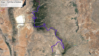
The first leg of the BDR - from Dell City to Ruidoso - was something over 250 miles. Quite long from a BDR stage perspective, we suspected that much of it would be nicely graded gravel roads, and we held off on airing down for the time being as we make good time on the flats of the Tularosa Valley. One of the things that stood out here to us was the proliferation of ocotillo cactus - something we've really only seen in these quantities in Anza-Borrego, previously.


It took us about an hour and a half to wind our way up to NM-137 - the same highway where we'd started our day - and after our first dozen miles of pavement, we peeled off onto a road that traced Guadalupe Ridge north, our views significantly obscured by haze, clouds, and thunderstorms to our west.

Now nearing 7:00pm, we were looking for a campsite when a blooming chollo caught our eye. Highlighted by the long rays of the evening sun, we had no idea that this would be the first of thousands of vibrant chollos we'd see, so despite being hungry, tired, and hot, we got out to take a look.

Not much later we found camp. Actually, we found camp twice as the first site - with an especially breathtaking view off the edge of the rim - was infested with gnats and we opted for a site that was significantly less buggy but also a little less photogenic.

We made a quick dinner of tacos - as usual, a staple meal - and I deployed the tent with our heads facing east in the hope that we'd get to experience a light show at sunrise the next morning. It was probably 8:30pm when we climbed up the ladder, the temps still in the mid-90s °F; neither of us opting for covers as we enjoyed the gentle breeze blowing across our bodies.
I, for one, was asleep within minutes.
The Following Morning...
Hoping for a clearer sunrise than the hazy evening we'd experienced along Guadalupe Ridge the night before, I'd set my alarm for just right around 4:30am (well, I suppose 5:30am local time) and hit the snooze button a couple times before finally crawling my way down the ladder to an already-risen sun.


A few photos taken, we were still pretty tired from three full days of driving and not-a-lot of sleep, so I climbed back up to bed for another couple hours of shut eye. That still got us out of the tent by 7:30am, and we ate a quick breakfast of Cheerios and blueberries as I put away the tent and @mrs.turbodb packed up the back of the Tacoma. Soon enough, we were on the road, the hilly top of Guadalupe Ridge stretching into the haze.


The road here was well graded. Piles and piles of rocks - which appeared to have been cleared by hand, as opposed to a grader - lining the sides of the road. We made good time, and a bit more comfortably, as I'd aired down while we were in camp to make the ride a bit softer.

The road followed the undulations - away and towards the ridge - as it made its way north. There wasn't a lot to see here, given the territorial views along the top of the ridge and the haze in the valley - a bit of a bummer given that under clear conditions, we'd have been able to see more mountains in the distance, and whatever was in-between.


It took us an hour-and-a-half to wrap up the ridge, civilization slowly making itself known as we reached the final miles of dirt. A few days before Independence Day weekend, there were already - and may have always been - plenty of flags waving in the breeze.

Soon, we were on pavement and on our approach to the tiny town of Pinon, New Mexico. We had one final stop before reaching town, however, as I'd noticed several blooming prickly pear cactus as we'd come off of the ridge, but I hadn't wanted to slow down since I was sure there would be more, in a more convenient location. At this point, I wasn't sure, so I slammed on the brakes and hopped out of the truck to take a look. Man, it wasn't even 10:00am and it was hot!


With nothing to attract our attention in town - really, just a crossroads - we were soon on our way, still on pavement. We'd end up travelling 33 miles of the stuff, just a preview of what was to come on this trip. It was, without a doubt, the most pavement we've encountered on a BDR.

Eventually, we did turn off onto the dirt again as we wiggled our way through the Lincoln National Forest - to our delight, the haze clearing a bit as our elevation climbed to 8,000 feet.

The dirt lasted forty-five minutes of so, and then we once again found ourselves on pavement. This time, we were on NM-6563 - the Sunspot highway - and we had a decision to make. The route followed the highway for a few miles and then peeled off - thankfully on dirt - to the west. However, if we kept going several more miles on pavement, we'd have the opportunity to visit the Apache Point and Sunspot Solar Observatories.
It's not like we had anywhere to be, so of course we opted for the side route!

At a fork in the road, we opted for the Apache Point Observatory first, and were able to wander the grounds when we arrived, though none of the telescopes were in operation - what with it being smack in the middle of the day!

With nothing really open, we were soon on our way to the Sunspot Observatory - only a few minutes away, and clearly with a sense of humor.

Unfortunately, the observatory and visitor center were closed on Tuesday, with the road gated about a mile before we could see anything, so we tucked tail and headed back the way we'd come - back down NM-6563 and to our turn off that would continue the BDR. Almost immediately we lost about 1,500 feet of elevation, and were right back in the thick of the haze, the forest - and whatever else was out there - fading into the distance.

It was getting to be lunch time by this point, so as we cruised through the trees, we looked for - and eventually found - a spot with some shade, where we could be a little off the main road in case someone else came blasting through. No one did - of course - and we enjoyed our tuna sandwiches, chips, and a cold apple in the shade of a pinion pine. Then, with many more miles to go, we were back on the trail and making our way north towards High Rolls and Cloudcroft.


We hit High Rolls first, but only for a second as we turned onto the highway towards Cloudcroft. We'd been hoping to visit Mad Jack’s BBQ for lunch - with a menu focuses on barbecue cuts by the pound, including angus beef ribs, pulled pork, and sandwiches, as well as the signature gut-busting Mad Jack consisting of sliced brisket, jack cheese and grilled onions and peppers (New Mexico Travel Guide) - but @mrs.turbodb discovered that they were only open Thursday through Sunday... a huge bummer.
One other thing I was excited to see however was the spectacular Cloudcroft Trestle. Also known as the Mexican Canyon Trestle, this gently curving arch is was built in 1890 for the on the Alamogordo and Sacramento Mountain Railroad. Promoters built the railroad to haul timber out of the mountains and carry tourists to an ornate resort hotel at Cloudcroft. Exhaustion of the wood supply forced abandonment of the line in 1947. (Echoes of the Past: New Mexico's Ghost Towns)

The railroad climbed an average 5.2% grade on its way to Cloudcroft, with 122 wooden box bridges, 58 timber frame trestles and around 330 curves. Down the canyon from this point, the train had to maneuver a switchback, which required the train to travel in reverse for a portion of the track. Travelling up such steep terrain was unusual for a standard-gauge railroad and called for extreme caution by railroad workers. Train wrecks were common due to heavy loads, often slippery tracks, and weather which could wash out entire lengths of the railway.


Having explored the trestle, and with no ability to consume meat by the pound, we filled up with fuel in Cloudcroft and continued on our way - to High Rolls once again, but this time via a(nother) back route.
Along the way, we spotted a sign for u-pick cherries, and having missed our favorite u-pick at home - which started picking Bings on the same day we arrived in New Mexico - we couldn't help but stop in for a few of the tasty little morsels.

After a quick chat with the owner, we were on our way with a couple coffee cans and fully canteens of water - it was 4:30pm and easily over 100°F at this point. The trees in the orchard were smaller than we're used to - no ladders were necessary to pick the fruit - and we'd later find out that they were only eight years old. Nevertheless, the Black Bings they contained were quite tasty, even if they were on the small side.

In the end, this turned out to be a fabulous stop, and we walked away with a pound of cherries at a reasonable - for being in the middle of nowhere - price. If you're ever in the area, and it's cherry season, definitely check out Cadwallader Orchards.

From High Rolls, we were back on pavement for quite a while. In fact, we'd considered a side trip to White Sands National Park at this point, but with partly cloudy skies, the sun getting lower in the sky, and still having not completed the first stage of the BDR, we decided to pass. A bummer, as I later discovered that Brent @PcBuilder14 lives in Alamogordo, which we'd have passed right through!

Instead, we continued on - finally making it to more well graded dirt, and eventually getting a few distant glimpses of the White Sands National Park. We were - both of us - ready to reach the end of the stage by this point.

And then - in what wouldn't be the only time it happened on this trip - we came to a horse in the road. Of course, we're used to honking cows out of the road, but this horse looked up and saw us, and seemed to immediately think, "friends." He stood his ground as we slowly rolled up, and then as I stopped, he wandered up to sniff the front of the truck and get a sniff of my hand and a pet on the cheek. It was quite sweet, actually.


Carefully continuing on so as not to spook the horse and end up with a swift kick to the quarter panel of the Tacoma, we made our final push on dirt - if you can call it that - under cloudy skies, sun rays forcing their way through in the distance.

A few dozen miles before the end of the stage, we hit pavement - first through the Mescalero Apache Reservation. Here, as we passed through town, the thing that caught our eye was the artwork on all of the retaining walls next to the highway. We're used to seeing graffiti, but on every single wall was a (series of) murals depicting the values of the local tribe.


And then, 15 miles later, we reached the terminus of the stage - Ruidoso. Even with its length of 258 miles, I don't think either of us thought this stage would take an entire day, but in the end, that's exactly what it took - one of the longest legs I think we've ever run.

Already 6:30pm, it was time to start looking for camp. That meant getting out of town and into the woods - hopefully reasonably nearby - so we could make dinner and deploy the tent for a good night rest.
But even nearby campsites can be full of surprises, something we'd discover over the course of the next hour!
The Whole Story


Love Backcountry Discovery Routes? Check out the
BDR Index
for all the routes I've run - they are fabulous!


")
")
")


")
")