
We had a hell of a time getting out of Elk Mountain. Well, not exactly out of town per-se, but out of the Conoco fuel station along I-80, just a few miles away. With gas prices as they are, I'd downloaded the Conoco app to save $.10/gal; let me tell you - that thing is a piece of crap. Credit cards added to your wallet are "lost" from your profile every time the app is restarted, requiring all the details to be reentered. The problem is that you can only enter five cards total, and the back end seems to remember all the "lost" cards, so pretty soon, you can't add your card anymore. But hey, at least we saved a whopping $1.60 for our trouble. 
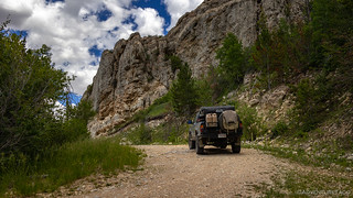
Leaving the frustration behind and pavement behind, the strangest structures rose up in front of us as the landscape changed - from the mountains we'd encountered so far, to Wyoming high-desert.

Ultimately, we decided that we ought to just "carry on, nothing to see here" - rather than poke around some strange building on private land - and we pushed north. It was 11:30am at this point, and with outside temperatures in the mid 90s °F, I can assure you that only one of us didn't mind as we ran into our first gate of the adventure. 

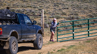
We'd run into three more gates in quick succession over the next mile or so, quite the concentration, given that I think we only ran into a couple more on the entire route! Still, they were easily returned to their original state, and after 15-20 minutes, we found ourselves approaching the ghost town of Carbon [1] [2].
Note: The ghost town of Carbon and its cemetery - while marked with a waypoint on the official BDR route - is on private property and is historically sensitive. It is important to show respect to this place. If in doubt, enjoy it from the road.
To our surprise, there were people there, digging! "Some sort of restoration?" I mused, as we found a place to park along the side of the two-track road, and wandered up the hillside to check out some of the rock wall ruins a little further away.

After poking around a bit on our own, we wandered over to the cluster of folks sifting dirt and carefully excavating under the mid-day sun, to introduce ourselves and see what they were up to. Turns out, they were from the Department of History at the University of Wyoming and had been here for a couple summers, doing research around the old townsite and nearby cemetery.
As we chatted with the two women in charge - Prof. Kelly and the site manager Aubrey - it was great to share stories with folks who were out enjoying the backcountry, albeit in a slightly different way than we were. We were - as always - curious about what they were up to, and they were similarly curious as to what the heck we were doing out here! After describing the concept of the BDR trails, and some of where we'd been so far on the WYBDR as well as where we were going, they seemed to think it was pretty neat, would explain the increased motorcycle traffic they'd seen, and was also... a bit worrisome.

Their worry, understandably, is that places like Carbon - which have historically seen very little traffic - might start to become overrun with riders. Unaware of the sensitive nature of these historic sites, artifacts could be inadvertently ruined or even removed. Certainly a concern of ours as well, we conveyed our hope that other explorers would show the same respect we do, leaving things as we find them, taking only photos.
After chatting for 20 minutes - all of us, I think, enjoying the interactions with a different group of humans out here in the middle of nowhere - we thanked the researchers and covered the last half mile or so to the cemetery.

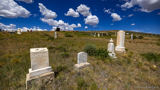

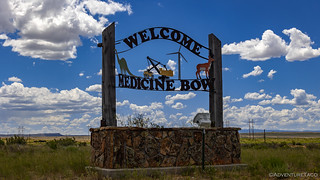
After wandering in the sun for the better part of an hour between talking to the excavators and looking through the headstones, we were both hot and hungry. The problem, however, was that the only shade for miles around was a solitary tree in the cemetery, so we hopped back into the Tacoma and set off towards the town of Medicine Bow, hoping we would find a shady park where we could cool down and refuel.
It turned out to be a reasonably short distance to Medicine Bow - the WYBDR following US-30 for about 10 miles - but we're easily distracted, and an ungated wind farm just next to the highway was too much for me to pass up.
I should note that - like Carbon - the Seven Mile Hill wind farm is on private property. We did run into an employee there who seemed to be OK with me taking a few photos, but it's important - obviously - to be respectful of their operation and to keep a safe distance from the generators. Even from the highway, you can get pretty darn close.


After a few minutes of geeking out on the windmills, I was back in the truck and we covered the last few miles to Medicine Bow. There, we found a perfectly shady park with several picnic tables in the courtyard of the museum. As usual, I set about snapping a few photos while @mrs.turbodb expertly crafted the turkey sandwiches that would fill our bellies.


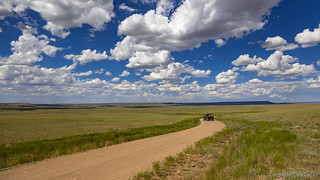
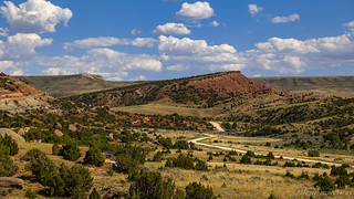
With lunch behind us, it was early afternoon - 1:30pm or so - when we headed north out of Medicine Bow, toward the Shirley Mountains. The first 30 miles or so was pavement, but with green grass lining the highway, and pillowy white clouds in the sky, I wasn't complaining.


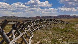

As with each leg so far, the views as we gained elevation were spectacular. Stretching out into the distance, red badlands wrinkled around us, their folds accentuated by the freckled shadows of the clouds above. And there, churning away, were the powerful turbines we'd admired earlier.

(Is this you? CO plate DNK ###. Contact me.)
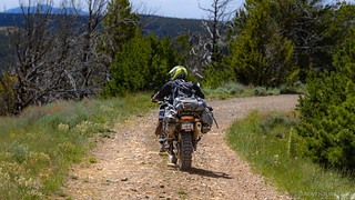
After returning the glove, the BDR riders from the Denver area of Colorado ended up stopping in some shade - though in all that gear, they still must have been hot - as we continued on through the mountains. We'd see them again - they were much faster than we were on the smoother parts of the trail - but only as we dropped down towards the end of the stage at Alcova. For now though, we were in the lead, moving at our leisurely pace, stopping as interesting elements popped up.


It was at this point that the detour for which this story is named takes place. As such, it's worth prefacing the whole thing with a bit more info. You see, the good folks over at RideBDR know that any route they create is bound to have sections that are closed - or otherwise require rerouting - at any given time, so they have a route updates page where riders can get the latest information on a given BDR. Even though there really shouldn't be any modifications to the WYBDR - given that it's the first year of this route - some last-minute road work on the highway (Kortes Road) leading into Alcova - the town, and more importantly fuel, at the end of the stage, caused the need for a bypass around the opposite side of the Alcova Reservoir.
But the big orange signs posted on the road simply read: "Road Work, Next 7 Miles."
Now, 7 miles was the entire distance into Alcova, so the genius in the driver seat figured that maybe the road blockage was over and we could avoid the 30-mile reroute around the reservoir. This is in contrast to the motorcyclists, who were immediately in front of us at this point and dutifully followed the directions provided by the BDR organization.
Anyway, as is probably obvious by now, the signs were wrong and two miles up the road, it was still closed.

It was, as we were turning around, that we noticed a small sign for a "Dinosaur Trail" at a road that seemed to lead down towards Alcova Reservoir. Curious - as always - I suggested that we follow it, hoping that we'd see some cool dino tracks or fossils.
Climbing out of the truck at the trailhead, it was 98°F, and we could see that the well-trodden trail went straight up the sandstone hillside in front of us. We should have retreated to the comfort of the Tacoma at that point, realizing that - surely - nothing all that amazing could be up such a well-worn route, but we didn't. And of course, by the time we got to the top, it was clear that this trail was more about the educational placards than it was about actual dinosaur bones or tracks (though, one sign did suggest there were tracks - which we couldn't find, and another hinted at bones - also missing in action).
We did, however, get to see some fossilized sea shells.


It was as we were standing at the top of the mesa - each of us quite sweaty at this point after the 400' climb - that I suggested what I think @mrs.turbodb had been thinking the entire time: "Wouldn't it be nice to go jump in the lake?"
We could see roads down to the water line, and there were most definitely boats out on the water. Figuring that the worst that could happen was utter disappointment, we retraced our steps to the Tacoma and turned the A/C to full as made our way to the water's edge.

We were overjoyed to find that it was swimmable, and we changed quickly before jumping in to wash the sticky off our bodies. Let me tell you, this detour was the best thing that could have happened to us. Even without soap, it was so nice to get clean - the water temps were perfect, and by the time we climbed out ten minutes later, not only were we refreshed, but our core temperatures were down. Even now, @mrs.turbodb recalls this as her absolute favorite moment of the entire adventure.

Well, our little detour couldn't last forever, so after splashing around and cooling down for a spell, we donned fresh clothes and continued on our way. Or rather, we backtracked to the spot where we'd exited the Shirley Montains, and set off through Fremont Canyon on our way to Alcova.


It was 6:00pm when we pulled into Alcova to top off the tank with fuel. At our lowest elevation of the trip so far - only 5300-feet - it was hot, and while we were both ready to find a camp site, we knew that we needed to gain some elevation first. Only one question remained - was that even possible to do?
The Whole Story


Love Backcountry Discovery Routes? Check out
BDRs we've run
to find your favorite.


")
")


")
")
As always, a good, entertaining read with excellent photos. Lodgepole pine is good for many things because of the long straight grain including utility poles!
Utility poles make sense... except that I feel like the lodgepole I see are always way smaller in dimension than a utility pole. Perhaps I'm always seeing second or third growth, though...
Don't know about that but I've read that the lodgepole pine generally grows to about 24" diameter, definitely large enough for a utility pole. Because of their straight grain they are also used quite a bit in plywood.
another excellent trip, it is great how the sky cooperates with the majestic blue sky and the poofy clouds. A buddy of mine and I use to ride DP bikes all over Idaho, Oregon and Nevada. As always great photos, keep on exploring.