
Having arrived at our middle-of-a-random-field BLM camping location just after midnight, there was no getting up for a pre-6:00am sunrise. Rather, we climbed down the ladder at nearly 8:30am to temperatures that were already in the mid 70s °F.
With no breakfast to make - as we'd decided to skip bringing milk in favor of more room for lunch and dinner fixings, we set about breaking down the tent and prepping for our first day on dirt. We still had a few hours to drive to the beginning of the trail, but then we'd be setting off on the first "Stage X" route ever released by the BDR (Backcountry Discovery Route) organization - Wyoming's Red Desert.
This year, BDR will be introducing a new concept of BDR-X, shorter, BDR-style loop routes off of the existing BDRs or an entirely new route in an area we’ve yet to bring a BDR to. Already, a number of BDR-X routes are planned for release in the next few years, expanding the BDR-style riding options for the ADV community beyond the official BDR routes.Inna Thorn, BDR Executive Director
And so, it was just after 11:30am when we turned off of WY-789 and onto the wide gravel road that would begin our journey. Almost immediately, the landscape wasn't what I'd expected (though I think it surprised @mrs.turbodb less, as she's generally more up on the industries spread across our country). As far as the eye could see, oil and natural gas wells covered the ground, service roads running between each, shuttling pickup trucks full of workers as we made our way north.

We weren't on the trail more than 10 minutes before a speeding oil company truck approached us at high speed from the opposite direction. Speeding along at 50mph, the driver made no attempt to slow down or move from of the center of the road, as I hugged the shoulder and lifted a few fingers in a wave. And then, as he raced by, I saw it coming - the rock his tire had flung into the air!
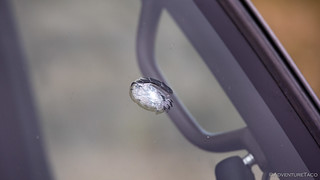

At the time, I felt like it was the most underwhelming start we'd ever had to a BDR, though as I write this, I can't help to recall our disastrously bad start to the Oregon BDR. Of course, there was nothing to do but to push onward - at the end of the day, costs like this are just part of maintaining a vehicle that can take us all over the country - and it's important to take these types of things in stride.
Besides, the weather was gorgeous, and we were both looking forward to lunch overlooking the Red Desert.


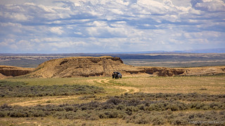
Headed west along Delaney Rim, we found ourselves several hundred feet above the Red Desert to our north, with views down into the colorful badlands that give this place its name. After a few stops for photos, we eventually found a spot - perched out on the edge of a finger - that seemed the perfect place to enjoy some turkey sandwiches and a few cherries that we'd picked ourselves just a couple days before heading out.


Our turkey sandwiches, some potato chips, and a few tasty cherries behind us, we turned away from the rim overlooking the Red Desert as we began the southern segment of this Stage X loop. It was one of the more beautiful sections of the loop in my opinion, and apparently a relaxing section for my copilot - who almost immediately nodded off for her afternoon siesta - as we made our way through gentle buttes towards the old route of the Overland Trail.


In operation from 1862 to 1869. The station and nearby fort were both constructed of flat slabs of fossilized snail shell sandstone (Turritella) that is prevalent in the near-by hills. Originally built as a Home Station, it later became a Telegraph Station along the Overland Trail.

The fort, established in 1863, included a barracks, a corral and a gun tower. On surrounding hills, gun pits were constructed and maintained. In June 1865 Company B of the 11th Ohio Volunteer Cavalry - then posted to Fort La Clede - skirmished with Indians some two miles east. The soldiers were drawn into an ambush and were rescued with the assistance of employees of the Stage Station. (The Overland Trail)


With not much left to explore and 92°F temps, we only spent a few minutes poking around the ruins, the mid-afternoon sun beating us back to the confines of our air-conditioned transport. Here, the road turned east - back toward WY-789, where we'd eventually head south to the start of the official WYBDR route, First though, the landscape changed again as we entered a region known as Adobe Town.


It’s tricky to try to describe a place that everyone in Wyoming knows about but where relatively few people have been. Sinking into the landscape - rather than rising above - this is a place that can take hours to find, even if you’re looking, or is easily never be found by those who aren’t. It’s a place where wild horses bunch and scatter and raise their young. It’s a place where pronghorn race cars that dare traipse down the seldomly-used roads.


A few miles later we climbed out of Adobe Town and back onto the plateau. From here, the lightly travelled two-track slowly became well-defined, eventually meeting up with the wide gravel roads of the oil-and-gas fields to our east. Our speeds increased, we soon rejoined pavement for the final push south.

It was 5:00pm and the border between Wyoming and Montana was calling. With several hours of daylight remaining, it was time to start the official WYBDR.
The Whole Story


Love Backcountry Discovery Routes? Check out
BDRs we've run
to find your favorite.


")
")


")
")