
Unlike most other BDRs we've done, getting to the start of Wyoming Backcountry Discovery Route, for us, meant travelling just a bit of the route backwards - south on WY-789 towards Baggs - first. And Baggs - it turns out - is a couple miles north of the Wyoming-Colorado border. So, upon arriving, we drove right through town - determined to run the entire route, from border-to-border. We were, we convinced ourselves, not cheaters!


As any good BDR traveler knows, you fuel up where you can, so after making our way back to town, we topped of our tank before heading north out of town on WY-789. Ten miles later, we turned off of pavement and onto dirt, the first stage officially underway!
Already, the difference between this stage and the Red Desert Stage X that we'd run earlier in the day was striking. Climbing the eastern foothills of the Sierra Madre, the undulating hillsides were green under the warm evening sun.

In the distance, tanks. Reminiscent of those we'd seen earlier in the day, we wondered if the entire route wound its way through oil fields. But - as we got closer - it became clear that we were now in ranch land; these tanks held water for the steaks that vacationed here from time to time.

Even though we'd started this stage when most folks in town might have been prepping or even settling down to dinner, we'd gotten a late start to our morning and hoped that we'd be able to climb at least a few thousand feet into the Sierra Madre in order to find a cooler camp site to call home for the night. The roads appeared to be in our favor, and we made good time as we snaked our way through the foothills, stopping here and there to admire the landscape - and sky - around us.


Continuing around the northern flank of Muddy Mountain, we had an hour of sunlight left as we descended into the Savery Creek Valley, and I for one was starting to wonder whether we were going to end up "settling" when it came to a camp site for the evening. It wouldn't be here - the creek and greenery meant that the mosquitoes were thick - but given that we still needed to make dinner, we knew we needed to find something sooner rather than later.


From the ranch at 6700', the next 10 miles of track took us to 8300' - enough to make the temperatures much more pleasant and still give us plenty of light by which to set up camp and make dinner. In that time, we'd passed through our first grove of aspen, their white trunks glistening in the sun as they lifted their bright green leaves to the sky.

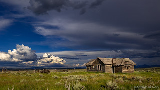
There was only one issue with our camp overlooking the Sierra Madre: it was paved. We were - it turns out - on an old spur of WY-70. This spur - it turns out - had once been the highway itself, but a landslide rendered the road impassable. Rather than clearing the material, it was determined that re-routing the highway was a better long-term solution, the original highway spur now signed as a viewpoint.

After a quick conversation about the likelihood of anyone else coming along - in the 10 hours before we planned to leave in the morning - we concluded that we were unlikely to encounter anyone else along this lonely stretch of highway, and we proceeded to prep our first dinner of the adventure.
Our location - paved as it was - turned out to be great in that the pavement resulted in a complete lack of bugs, and that meant we were able to eat our taco-ritos unmolested by the mosquitoes that we'd dodge for much of the rest of the trip. It was - despite the unconventional groundcover - fantastic.
Though we'd gotten up after 8:00am, we'd driven for more than 12 hours. Tired, we putzed around for a bit after eating dinner, but soon climbed up into the tent for some shut eye.
The Following Morning...
As we suspected, our evening on the old WY-70 highway was uneventful and while I'd set my alarm for a few minutes before sunrise, it wasn't until an hour after the fiery ball started climbing into the sky that we actually climbed down the ladder to start our day. Even then, our bodies still screamed that it was really 5:37am; Mountain Time be damned!

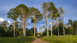
Soon we were underway, the track quickly turning to dirt less than a mile beyond our camp site. Here, we entered a section of trail known locally as aspen alley, where the trees rose tall as they crowded the road. We'd pass through a few aspen groves over the course of our journey, each time making me wonder if we should have waited until fall to enjoy this route.

From there, we began a circumnavigation around the north flank of Bridger Peak. This was a pleasant drive in the cool morning air of the Medicine Bow-Routt National Forest, as the road wound its way through the firs and pines that covered the land.
It's in the middle of this section that the BDR splits - the first of several "alternate" routes that are designed for "expert" riders who are willing to put up with gnarlier roads in exchange for extra fancy views. I assure you - every alternate route is worth taking; we've never been disappointed.

So early in the season, getting up the trail did turn out to be a bit of a muddy mess in a couple places, but nothing the nearly-new Cooper ST/Maxx tires couldn't handle with relative ease, and soon we were making our way along the ridge toward the summit. Patches of snow dotted - and in some places, covered - the road. We'd timed it perfectly - a week before, this area wouldn't have been passable!


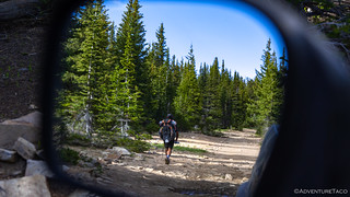
And then, as we were admiring out surroundings, we noticed a guy walking towards us! To say we were surprised would be an understatement, but we both soon realized exactly what was going on. This portion of the route happened to follow the Continental Divide Trail - which we've followed before - and this was likely someone making another border-to-border journey; one much longer than ours! As we rolled up to the hiker, I slowed down and said good morning.
"You hiking the Continental Divide?" I asked.
"Yeah buddy," he replied, a huge grin on his face, his top two front teeth completely missing.
He was obviously having a great time, and seemed happy enough to chat with us for a few minutes about his journey from the Mexican border a couple months earlier, and the remaining 2-3 months he had on the trail to Canada. Wow. We'd end up seeing four hikers in the span of the next hour - each of them aware of each other, but none of them seemingly friends.
A few minutes later we wound our way up the final rocky trail to the old Bridger Peak lookout. Only the foundation - and a new radio tower - remain at the summit, but it's clear why this location was once used for a lookout; it certainly sports a commanding view of the surrounding area!


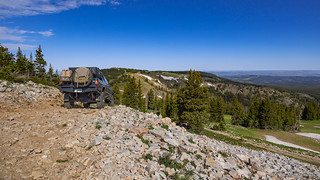
As the alternate leg over Bridger Peak came to an end, we wound our way down toward the town of Encampment, stopping at a few Wyoming wildlife and CDT informational signs posted along the way. We were a little more than halfway through the first leg, and it was proving to be one of the best starts to a BDR yet!
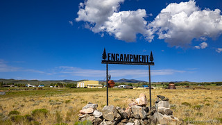
The mining boom at Grand Encampment started in 1897, when sheep herder Ed Haggarty found copper several miles west of town, on the west side of the Continental Divide. Hordes of miners and speculators flocked to the area, raising a town (Grand Encampment) on the hillside above Doggett (which later became Riverside). Hundreds of mine shafts went down into the rocky soil.
In 1899 Haggarty sold his initial interest in the mine for $30,000 and [over the next 15 years the town thrived].By 1902 a smelter reduction stood on the hillside above the river [generating $40,000 a month]. Businesses opened almost daily in the town of 1,000 residents.
[But] fires at the smelter, delays in getting a railroad line to the community, and falling copper prices stalled the boom and by 1913 the smelter had completely shut down. The population of Grand Encampment fell by half. Today, the "Grand" has been dropped due to postal regulations, and Encampment has about 400 residents and, some say, a similar number of dogs.Roadside History of Wyoming
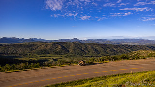
Exiting Encampment a little after 10:30am, we were back on well-graded gravel roads for the remainder of the stage - some 50 miles or so - across the North Platte River, on our way to Centennial. Along the way, the landscape varied. First - as seems to be common to all BDRs - was cow-covered ranch land. This being the first stage, we didn't think anything of the wandering cuts of beef, but by the end of the trip, we found ourselves surprised by the lack of active grazing along the route. Perhaps we just hit the trails at the perfect time, but one thing was for certain - we weren't complaining!

(To @mrs.turbodb's dismay, I have a tendency of muttering "dumb cows," under my breath any time we pass the tasty morsels.)
A little further out of town, we began to climb into the Medicine Bow Mountains in search of somewhere to eat lunch. Here, we were presented with a reminder of the fires that have ravaged the west over the last several years - remnants of the 2020 Mullen Fire, which had burned more than 176,878 acres across the Savage Run Wilderness and Medicine Bow Mountains - affecting the forest for decades to come.


Inexplicably, as we were eating lunch at the lake, nearly a dozen people converged from all directions - a traffic jam in the middle of the woods on a Thursday afternoon - and we reflected on the luck we'd had to show up at this primo lunch spot just a few minutes before it'd have been snapped up by any number of other hungry travelers. Of course - with a full itinerary ahead of us - we didn't linger longer than necessary, and soon we were wrapping up the stage as we pushed into the town of Centennial.

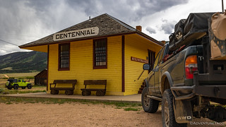
Having pulled into town at 1:00pm, we'd completed the first stage in less than a day. It was too early to celebrate though - because I knew the following stage - where we planned to reach elevations over 12,000 feet, 1,000 feet above the snowy trails on Bridger Peak - had the potential to slow us way down.
The Whole Story


Love Backcountry Discovery Routes? Check out
BDRs we've run
to find your favorite.


")
")


")
")
Great trip, some of your best photos of all trips. Keep it up, we all enjoy your adventures and photos.
Thanks Kenny! Sure hope you’re having a chance to get out and enjoy the summer in your new toy.