
I could have included this stuff in the main East Mojave Heritage Trail stories - and usually I would have - but they were already getting long. Plus, I know that most would prefer YouTube videos anyway. Not that there will be any YouTube videos here, if I just got your hopes up. Anyway, this is a mishmash story of a few things that weren't explicitly part of EMHT Segment 4, but that I experienced during that same span of time.
The Copper Glint Mine
As I was leaving Las Vegas - my body and the Tacoma both resupplied after my flight south - it was only slightly after 2:00pm. This is earlier than I usually get out of town - the pilot on my flight must have needed to use the bathroom or fallen asleep with his foot on the accelerator or something - but still late enough that by the time I got to the starting point for Segment 4 a few miles south of Fenner, it was going to be dark. At 4:30pm. Yuk.
To salvage a bit of the day, I convinced myself that I could make a quick pit stop on the southeastern flank of the Clark Mountains for a quick hike to a mine site that I've passed several times, but never taken the opportunity to explore - the Copper Glint Mine.

Just opening the door to take a few photos of the mine from a distance, the overwhelming aroma of gasoline filled my nostrils. Luckily, I'd just finished lunch; on an empty stomach, I'd have been high as a kite as I worked my way to the back of the Tacoma to find one of my Scepter jerry cans leaking a bit as it was jostled over the rocky terrain.
Close inspection showed that something was amiss with the threads on the jerry can side of the equation, causing the lid to not seal completely. Making a mental note to empty the can when I got to camp, and then pick up a new one when I got home - these are by far the most trouble-free jerry cans I've ever seen on any rig - I climbed back into the Tacoma and drive another couple of miles to what seemed to have been the scrapyard for the Copper Glint.

The scrapyard also happened to be the end of the road - or at least, as far as it is passable in a vehicle these days - so with less than an hour until sunset, I gathered up a few LED puck lights and my tripod and headed up the mountain. I was sure that this was going to be a fantastic place to poke around - probably well into dark.
Naturally then, I forgot any sort of flashlight. 


Rounding a bend in the shelf road, I stumbled on the first digging. Small and shallow, I thought this might have been a shelter, but the lack of rusty cans and other trash probably meant that it was just an unsuccessful prospect.

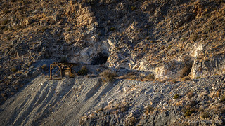
By the time I reached the main adit, 45 minutes had passed, and I was keenly aware that I'd neglected any sort of light - with the exception of LED pucks - to get me back down the mountain. Smarter me might have headed down with the last of the light, but I forgot smarter me at the bottom with my flashlight, so I carried on with my exploration.


Satisfied that I'd snapped a photo of anything that would need daylight, I turned my attention to the "definitely safe" interior of the adit. "Definitely safe" might have been generous in this case however, as I soon noticed the lack of any sort of wooden supports, several collapsed metal ladders, and a black soot covering the walls and ceiling of the adit.
Yep, everything that'd been supporting the mountain around me had - at some point - burned up! It hadn't happened in the last day though, and everything was still standing, so I figured that I'd probably be "totally safe" for a few more minutes while I bumbled around setting up lights and snapping a photo or two.

With all the fallen material, it was a tedious process getting the puck lights positioned, and by the time I was done, I'd burned another hour before I stumbled back down to the Tacoma. It wasn't all that late, but with no moon, it was sure dark!
The Goldome Mine
Normally to get to Fenner from the Copper Glint Mine, I'd have taken Cima Rd. Unfortunately, it's closed this winter as NPS makes major repairs, so Google Maps suggested I work myself all the way back to over Mountain Pass to US-95 and head south from there.
That's dumb. Ivanpah Road is a perfectly good dirt road through the Mojave Preserve - and would cut many miles off that journey - but no matter how many waypoints I set along the length of the road, Google wouldn't map it. Turns out, Google won't map any dirt roads in the Mojave anymore, after some bozo's blindly followed some directions onto a sandy road and promptly got stuck. Because why would you ever question turning onto a sandy dirt two-track in your Tesla? Surely it could never be their fault.
Throwing all caution to the wind - could I even make it without some dumb little computer telling me to "continue straight for 47 miles"? - I turned onto the route that I've travelled many times and would save me nearly an hour. Plus - I realized - going this way, I wouldn't have to deal with traffic at all, and could cruise along at 50mph and my sun-like SS5 light pods blasting away.
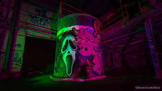
Only as I passed the turn did it even register that I was in the vicinity of the Goldome Mine. We'd visited on our second, "redemption" trip to the Mojave Preserve, but since then, Mike @mk5 had toured the place at night - just before meeting me in Death Valley for a Loosely Planned Meetup - and I couldn't get him to shut up about how creepy the Goldome was at night.
Ready to prove that he was a complete wuss, I slowed down, threw the Tacoma in reverse, and soon I was making my way along the old rail grade and past the once-locked entrance gate. My plan was to put a few of the puck LEDs that he'd so graciously given me to good use. I'd show him - and the world - just how much more macho I was and come away with some cool photos at the same time. You know, win-win, for me! 
My plan started going sideways even as I was positioning the Tacoma for my first photo.

As I moved on to the main structure, the wind really started to pick up. All the corrugated steel was rattling. Barrels were rolling around on the desert gravel. Birds - sleeping soundly until my arrival - began divebombing me as I placed the LED lights around the creaking structure.
Damn, I realized, Mike was right. This place was f@#$#$ creepy.


After jumping at a dozen or more noises in the span of the 60 minutes that I suffered through the Goldome Mine, I was ready to go. Even putting my camera equipment away was an exercise in nerves, stray reflections from my headlamp and gusty winds nearly convincing me that I was not alone.
I was glad to be back in the truck and headed to Camp Clipper.
The Blueprint Petroglyph
One of the reasons I'd been looking forward to the fourth segment of the East Mojave Heritage Trail was because it travels through the Turtle Mountains, a place that @mrs.turbodb and I had searched for - but never found - a petroglyph that is reasonably unknown. I wasn't sure that I would have time to search again on this trip - and in fact, I'd resigned myself to the fact that I would not - but when I ended up in the area with only an hour of light remaining in the day, it seemed like the perfect opportunity to cross my fingers and give it another go.

For a bit of variety, I decided to take a different route than the one we'd hiked previously. Where we'd gone counter-clockwise, I decided to head the opposite direction, perhaps spotting a rock face that would have been facing away from us on our previous visit.


I reached the saddle with only a few more minutes of sunlight on the hillsides. There to my left - and surely not new - was an arch! Perhaps this was the arch that the nearby Lost Arch Inn was named for. Regardless, it was an exciting discovery as I continued along my loop.

Unlike my hike to the Copper Glint Mine, I'd remembered to bring both my flashlight and headlamp on this little excursion, so as the sun dropped below the horizon, I continued to look on every rock face I could find for the Blueprint Petroglyph. Alas, as with the previous search, I came up empty in the rock art department. Or - at least - of the human-created variety; nature's rock art was on full display!


Working my way back to camp, I recalled @mrs.turbodb saying - the last time that we'd done this hike - that the hike was so nice that she didn't mind that we never found the petroglyph. At the time - though I agreed that the hike was nice - I'd been disappointed. This time - since I'd gone into the hike knowing that I'd probably not see the glyph - was just the opposite: with the light and rocks playing so nicely together, it was one of the more pleasurable hikes I've taken in a long time!
And it wasn't without a bit of rock art. I did find a few newer specimens as I worked my way down the old miner's trail.


The Whole Story


Looking for other segments of the EMHT? Check out
East Mojave Heritage Trail
for other trips where the other parts of this epic route were enjoyed.
More beautiful photos and fine narration, thank you! As for Google directions, I do not trust them so I check satellite photos and other sources also. Several years back we hopped into our little car to head over to Barstow but instead of taking our usual route I used Google & GPS which mapped out a route that would save time & miles. About halfway into the trip we were told to turn left onto an "expressway." It turned out to be a dirt, WAIT, make that sand road. I got out and walked it for about 20' and it was bottomless sand that most high clearance 4x4 vehicles could not have negotiated so we had to backtrack and take a different route that I knew which cost us more than an hour. Since then I check out routes more closely before letting Google lead us astray.
Thanks John! Google has certainly given poor (or, unfollowable, depending on the vehicle) directions in the past, so I totally understand why they've made the change that they did - it's good for 99% of drivers. Unfortunately, I fall into that 1% that appreciated the off-pavement directions, even if only to suggest a possible route that I might not have noticed on satellite.
I've always assumed that other folks are smart enough to evaluate a road before they drive it - in the same way that you or I would evaluate the sandy route before just "driving in" - but obviously that's not the case given what happened to a bunch of folks in the Mojave. A sign of the times, I suppose, when folks blindly follow the directions their small screens spit out, rather than using their own eyeballs and common sense. LOL.
Yes, A funny addendum to that is some years ago when I was bicycling out in the desert (pretty far away from any residences), I saw one of the little Google mapping cars driving off across the desert on a pretty rough dirt/sand road and wondered if that road would show up on their maps as a highway, LOL! For a couple of weeks I saw those little cars (or maybe the same one) crisscrossing the desert on dirt roads.
I hate seeing that graffiti everywhere you go. It's a sign of a country in decline...Europe is full of it too, even the fountains in the squares of Italy. So sad.
At least we both managed to get to that mine south of Winnemucca before it got tagged into oblivion. I'm headed down that way the third week in May for ten days. I don't think we will go back up there but we will be all over the Dixie Valley/Clan Alpine area checking out some spots I've visited over the last three decades.
I know you didn't mean it as a pun (or I assume you didn't), but I got a good chuckle out of your phrasing - "a country in decline" - because you could rewrite it in this particular case as "a country INDECLINE." (The name of the group that defaced the Goldome Mine.)
Hopefully the spot south of Winnemucca stays reasonably untouched. It's not as "prominent" as the Goldome, and off the radar. There's not much metal or concrete to cover with graffiti.
Have a great time In Dixie Valley. I'd love to hear if you find any more heavy machinery. That was such a surprise for us, and we'd probably make a trip down there to check out more (even though I'm sure it changes rather regularly). Plus, we probably need to go back to explore some of the mines in the area anyway.
No pun intended...but it is a great name for the graffiti "artists" for sure.
I doubt many people will make it up to that mine...too out of the way and the last 1/8 mile is sketchy as you know.
Dixie Valley is awesome...I've been going back there almost every year since my first trip in 1990...so long ago. Most of the tanks and other military hardware haven't moved in years. I just found some old panoramas of the area from around 2003 that I shot with an xPan that I used to have. I'll dig through my email and find your address and send them over. There was a huge junkyard near the intersection of Settlement and 121 that was full of interesting stuff but the navy cleared it all out about 15 years ago.
Let me know before you go down there again and I can fill you in on some good mines to check out. The back side of the Clan Alpine is full of them. The old townsite of Fairview is also one that is fenced off on the north side but I think you can get in the back way. There was a huge mill there and all that is left of the town is an old concrete bank vault.
Dang, the Goldome mine at night. If there is a fresh breeze, the siding makes an ominous noise...creaking with an occasional bang. The Creepy Factor must be x1,000,000 after dark.