Segment 1: Needles to Ivanpah - 173 miles Segment 2: Ivanpah to Rocky Ridge -199 miles Segment 3: Rocky Ridge to Fenner - 211 miles Segment 4: Fenner to Needles - 155 miles
This was the segment I'd been looking forward to the most - right from the get-go - given that I've only ever wandered through this neck of the woods once before, in search of a Blueprint Petroglyph. I didn't think that particular spot wouldn't be on my itinerary - at least, not until I decided to give finding it a second shot - but having skirted the Turtle Mountain Wilderness once before, I knew that this segment would be a treat!
- - - - -
After my usual fly-into-Vegas-and-provision routine, I didn't head straight to the EMHT. Rather, knowing that no matter how fast I drove, I was going to arrive at the starting point for Segment 4 after dark, I made a detour to a couple of places in the Mojave Preserve that I've wanted to visit but where timing just hasn't worked out.
With those stops, it was just before 8:45pm when I pulled onto the runway at Camp Clipper. It wasn't windy, but I was out in the open and totally exposed, so I fired up my phone to check the wind situation for the rest of the night.
Ugh.
With a forecast like that, I knew I'd be in for a rough evening. With reasonably calm winds at the moment, I emptied one of my jerry cans of fuel into the tank - as I'd noticed that the seal was leaking when I'd been out to take photos earlier in the day - and got the truck oriented so that the tent wouldn't fold up on me when the gusts really began. Then, after a bit of Lightroom work, it was off to bed!
The following morning...
As predicted, it was a windy night. Parts of it were pleasant - with earplugs, the sound wasn't too bad, and the rocking of the tent was rather nice - but I was not thrilled when I picked up the sound of driving rain against the side of the tent.
The first time I heard it was just after midnight, and I knew that the wind would easily dry everything out by the time I woke up. And, luckily, the winds died down for about 30 minutes just as I climbed out of the tent, allowing for a quick launch of the flying camera - the only way to capture the place in which I'd gone to sleep.
Morning at the Camp Clipper air strip.
Built in 1942, Camp Essex and Camp Clipper were built to prepare troops to do battle in North Africa to fight the Nazis during World War II. At Camp Clipper were trained the 93rd Infantry Division. The trained troops went on to fight in the North African campaign.
An air strip near Camp Clipper supported training activities. The runway consisted of two 4,500-foot-long runs made of steel landing mats with 6 parking pads at each end of the runway. The runway ran north-south, parallel to the old U.S. Route 66.
The runway was long enough for large planes - such as the Douglas C-50 cargo plane, Douglas A-20 Havoc, Curtiss P-40 Warhawk, Lockheed P-38 Lightning and Consolidated B-24 Liberator - to use in training exercises. In early 1950 the airfield was used as a private airfield, but soon fell out of use and was abandoned in the late 1950s.
You can just make out the Tacoma in the middle right parking pad.It was still dumping over the Piute Mountains, the direction I was headed!Things didn't look much better over the Providence Mountains to the west, either.
While most of the rain on the tent had dried, there were a few places that benefited from a little toweling off, so after taking care of that I ate a quick cereal breakfast and packed everything away. It was later than I'd hoped to get going - more than an hour after sunrise and just a few minutes before 8:00am - but at least the sun was winning the battle against the clouds, and it was turning into a beautiful day!
A quick stop under the train tracks. Should I be worried that there are some additional supports for some reason?
Only slightly phased by the additional supports, I did my best to put that out of my mind as I procrastinated climbing back into the Tacoma. Rather, all my energy was focused on willing a train into existence on the tracks.
Success! I manifested a train!Harder and harder to put those supports out of my mind.
Finally working my way further into the route, I headed toward the sun - and rather ominous looking weather - into the Piute Mountains Wilderness. This was a place where - during the springtime - I might finally get to see a desert tortoise, but given the cool temps in early January, I knew my chances were nearly zero on this particular morning. Still, there was plenty to keep me interested as I gained elevation. The landscape here - decomposing granite with yucca - reminded me of Joshua Tree National Park, and I found myself hopping out of the Tacoma too frequently to snap another photo.
I hoped the clouds would clear as I neared the Piute Mountains.After the previous night's rain, the yucca were a blazing green.The Providence Mountains in the distance were covered in a dusting of powdery snow.I really enjoyed the patterns on some of the granite as I neared the pass.Wonderlands of rock were reminiscent of Joshua Tree.
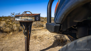
On each segment of the EMHT, there exists a mailbox. These aren't true mailboxes - such dainty containers would never survive in these harsh conditions - but are quarter-inch steel structures, able to stand up to the worst that the desert can muster. And, as I came to the last box, I'd soon find it to be the least-visited and most interesting.
The final box. Box 4.Inside, a bag of gold!Looks like this box went missing for a time, and Billy Creech was only able to reinstall the logbook in December of 2020.
I made sure to sign the book, but I thought the entry just above mine was even more interesting!
I had the opportunity to help as a junior member of Friends of the Mojave Road to layout the EMHT. It is now about 35 years later, and today I retire as the BLM Needles Field Office Manager. What a ride!
Mike W Ahrens
I always feel a little weird leaving anything in the desert, even in a log book, but there were few enough folks to sign in here that I thought it'd be fun to leave a little momento.
Whereas I'd spent only a few minutes at each of the other mailboxes, I ended up spending nearly half an hour perusing this last treasure chest, perhaps a little sad that there wouldn't be another one along the way. I may have also taken the opportunity to eat a bit of trail mix - or at least the peanuts and raisins, since I'm not a fan of the M&Ms that are the favorite ingredient of every normal person.
Then, after speeding through a sandy wash - the smoothest, engine-revingest, and downright funnest - section of trail - I made my way out of the Piute Mountains and into the Old Woman Mountains.
There was a time - only a handful of years ago - where getting into sand like this would have had me looking for an alternate route. Today, the soft, fluffy base puts a smile of my face!As I neared the Old Woman Mountains, the view across the valley - to the rugged Stepladder Mountains - was stunning.Pilot Peak was a recognizable landmark all along this section of trail.
Whereas there'd been a small reroute of the original EMHT to avoid wilderness through the Piute Mountains, the formation of the Old Woman Mountain Wilderness in 1994 meant that a rather sizable set of changes were necessary in order to keep EMHT vehicular traffic out of sensitive area. These updates also resulted in the route skirting a couple of old mines - the Gold Star and Lucky Jim - by a few miles, requiring that anyone interested in checking them out, hike to them - gasp - on foot!
The new route through this portion of trail was nothing to complain about!
It should come as no surprise that I was looking forward to the hikes to the two no-longer-on-the-main-route mines, and before long I'd abandoned the Tacoma on the side of the road and was working my way up the four-mile mining road to the Gold Star Mines.
Into the wilderness, along the original EMHT.
I've not been able to find any information about the Gold Star Mines, though there were at least two mines up this way and one of them appeared to be - despite the name - a Barium-Barite mine. And no, I have no idea what that really is, even after reading through as much of the wikipedia article as I could stand.
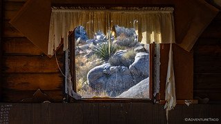
The nicer - and seemingly less-visited - of the two cabins.I don't generally find unbroken glass windows at a place like this.Not fully stocked, but a few useful bits and pieces if you wanted to take care of the place.
I was never able to find the actual mining site for this cabin, but it was - apparently - the Barium-Barite mine, so I wouldn't have known what to look for in the first place. Rather, I pushed onward - toward a cabin that was more prominent from the distance - and which appeared to belong to a more traditional tailings pile, high on the hillside.
Those are the types of windows I'm accustomed to. Glassless. With much of the roof missing, all of the doors and windows ajar, and infrequent visitation, this cabin was looking a little disheveled.A how-long-can-you-hold-your-breath competition must have taken place here!In my experience, miners rarely found riches, except in the views from their cabins.
I contemplated picking my way through the yucca, cacti, and granite to the old tailings pile another quarter mile and 300 vertical feet up the hillside, but ultimately decided that I'd better head back the way I'd come. I still had a lot of EMHT Segment 4 to run, and I needed to get far enough that I would set myself up to finish the remainder of the route the next day.
Predictably, the time I saved in hiking up to the Gold Star Mine workings, I almost immediately forfeited by hiking another mile or so to the Lucky Jim mine.
I'd seen these workings on satellite when I'd research the route, and while there were no structures, I'd spotted what I hoped would be an interesting adit to explore.There was no question about what Lucky Jim was after - the green ore all over the ground gave away his treasure - copper!This adit didn't turn out to be all that interesting. However, I was glad to have my N-95 mask, as the entire floor - from wall-to-wall and front-to-back was black. Covered in a 2" deep layer of mouse droppings, I'd never seen anything like it.
It was a few minutes after 2:00pm when I turned the Tacoma east - or rather, the EMHT turned east, and I simply followed along - away from the Old Woman Mountains and towards a place that holds a fair bit of mystery for me - the Turtle Mountains.
As with many of the ranges out here, the Turtles are old, jagged, and seem largely composed of volcanic material.
I'd only visited the Turtle Mountains once before. At the time, @mrs.turbodb and I were in search of the Blueprint Petroglyph, an elusive - we never found it - carving somewhere in the vicinity of Mohawk Spring. I'd tried - unsuccessfully - to figure out its location again prior to this trip, but having come up empty, I had no plans to look for it as I passed by on the EMHT.
The approach never got old.
This late in the afternoon, I was delighted to approach from the west, the sun illuminating the mountains, rather than silhouetting them in shadow.
Knowing my way around just enough to be dangerous, I swung the Tacoma to the right - bailing off of the official EMHT - as I noticed a BLM (Bureau of Land Management) road marker that appeared to run along the boundary of the wilderness area. My tablet suggested that this road would meet up with the main route a few miles ahead, still allowing me to check out the Lost Arch Inn, the "usual" attraction in this neck of the woods.
Layers and light.Before long, I was at the Lost Arch Inn. It has seen better days, but I've never seen it in better days.Things are not always as they seem. To learn anything about the Lost Arch Inn, you need to know where to look. Or, be really short.
Legend has it that a man named Amsden left Needles in 1883 to prospect in the Turtle Mountain Range. A few weeks later, Amsden staggered into Goffs, close to death but with his pockets bulging with gold. After recovering from his ordeal, he returned to his home in the east. Several years later, it is said that he penned a letter to Dick Colton, a friend in Goffs, with directions and a map to his placer mine in the Turtle Mountains. The letter said the gold was not far from a natural arch.
From 1922 to 1948 a pair of prospectors, Charlie Brown and Jesse Craik occupied a cabin near the suspected Lost Arch mine. While neither gave much credence to the legend of a lost mine, they nonetheless sampled much of the ground around the Turtle Mountains and held many claims, milling what they found on site. In fact, one claim - betrayed by the concrete foundation of their old mill - was one right behind the camp and tested at $3 a ton (for gold and silver).
As well, they welcomed visitors and dubbed their two cabins as the Lost Ach Inn.
The old mill foundation.If there's still gold here, it's not easy to access.
At this point, it was 90 minutes before sunset and I had a decision to make. I knew that there was some great camping - just across the valley and in the shadow of the Turtle Mountains - at the Lisa Dawn Mine. Or, I could push on - trying to cover as much ground as possible - and hope to find a spot further along Segment 4.
In a completely uncharacteristic move, I opted to settle down for the evening. I still don't know exactly what made me choose this route, but my night in the Turtle Mountains ended up being the most pleasant of my trip, so perhaps I should take it as a hint to slow down and smell the desert roses more often.
And so, with an hour to kill and having explicitly planned to forego a second search for the Blueprint Petroglyphs, I set off to do the opposite. Because hey, how hard can it be to find a single rock in 177,209 acres?
DB, i passed that old air strip mid 80's. I never got to check, but was any of the steel landing mats remaining? You going there reminded me of driving past it.
Great scenery and time of year to be seeing this area.
turbodbFebruary 20, 2024
Well, I don't know if there were any steel landing mats there in the '80s, but if there were, they are long gone now. Doesn't surprise me that anything salvageable for scrap might have been "liberated" from the site over the last 50 years, though - as always with places that get ransacked, it would have been cool to see the mats in their original location.
Even the runways are becoming too overgrown to drive now - only the southern end of the eastern one is really drivable in a vehicle. Though you can still easily make them out in photos, there's just too much plant growth on them at this point.
Stefan AndersonFebruary 21, 2024
What is up with the bag o' gold? Was it pyrite, or actual gold? If actual gold it begs the question: Why would someone leave a bag of gold 🙂
turbodbFebruary 21, 2024
That bag was left by someone as a joke, I assume. To me, the "gold" seemed too pure to be mistake for the real thing, and it wasn't very heavy, either. Still, a fun little treasure to come up on in the box! 🥇 💰
Tim AugustineFebruary 26, 2024
You left us hanging on the petroglyph search. I'm guessing you didn't find it.
turbodbFebruary 26, 2024
😁 I never have cliffhangers! (Except for always.)
There is one final chapter to this story, which I've named "Extras" and should be coming to your email soon (this week). There were a few places I visited on this final stage that weren't part of the stage itself, so I bundled them up into an untidy little box for the very end.


DB, i passed that old air strip mid 80's. I never got to check, but was any of the steel landing mats remaining? You going there reminded me of driving past it.
Great scenery and time of year to be seeing this area.
Well, I don't know if there were any steel landing mats there in the '80s, but if there were, they are long gone now. Doesn't surprise me that anything salvageable for scrap might have been "liberated" from the site over the last 50 years, though - as always with places that get ransacked, it would have been cool to see the mats in their original location.
Even the runways are becoming too overgrown to drive now - only the southern end of the eastern one is really drivable in a vehicle. Though you can still easily make them out in photos, there's just too much plant growth on them at this point.
What is up with the bag o' gold? Was it pyrite, or actual gold? If actual gold it begs the question: Why would someone leave a bag of gold 🙂
That bag was left by someone as a joke, I assume. To me, the "gold" seemed too pure to be mistake for the real thing, and it wasn't very heavy, either. Still, a fun little treasure to come up on in the box! 🥇 💰
You left us hanging on the petroglyph search. I'm guessing you didn't find it.
😁 I never have cliffhangers! (Except for always.)
There is one final chapter to this story, which I've named "Extras" and should be coming to your email soon (this week). There were a few places I visited on this final stage that weren't part of the stage itself, so I bundled them up into an untidy little box for the very end.
Until then though, you'll have to keep wondering!