Except for the burro that decided to "eee-aww, eee-aww, eee-aww" in the middle of the night a little ways up canyon from our camp site, Galena Canyon was one of the most pleasant nights I've experienced in Death Valley in recent memory. The level of the tent was just right; there was just the tiniest bit of a breeze to keep air moving; and temperatures were extremely pleasant in the low 40s °F. I was well rested when my alarm went off just before sunrise, and soon I was poking around the mining area that we'd discovered the previous evening.
I've never found gold at the end of a rainbow, but I've found plenty of treasure at the end of many a road.Weathered giant.Gleaming bright and speeding toward the horizon.
My first order of business - obviously - as far as investigating the White Eagle Claim of the Death Valley Talc Mine was concerned, was to check out the platform at the top of the ore bins. I could tell from the ground that it was an elaborate structure, but it wasn't until I hoofed it up the access road that I really got a sense of how cool it was.
The Death Valley Mine was originally incorporated on March 15, 1927 as the American-Italian Talc Company with headquarters at Tonopah, Nevada. The company boasted stock of 5,000,000 shares, with each share having a value of $1. Once acquiring only $1,000 in capital, the company proceeded to acquire claims in the Panamint Range and in the Black Mountains west of Tecopa.
In the fall of 1929, the company began assembling a work crew and preparing to make shipments from its mine in Galena Canyon. The vice-president of the company stated that it had several orders to fill, one of them for 1,000 tons of ore. As usual, output was not as good as expected and while the exact production level reached by the Death Valley Mine at this time is unknown, it was probably not more than a few hundred tons.
For the next few years operations were suspended, during which time the American-Italian Company went defunct, eventually emerging again in the summer of 1933 as the Death Valley Talc Company. $500,000 of newly authorized stock was divided into 500,000 shares and S. D. Pipin - former president of the American-Italian Company - continued in this position in the new organization.
A 1933 letter from the vice-president of the new Death Valley Talc Company to Superintendent White at Sequoia National Park (Death Valley at this time being administered under a joint superintendency with Sequoia National Park) informed him of the company's takeover of the American-Italian Company assets and of the new company's intention to ship some ore to the east within a few days' time. A camp had been established in the vicinity of the mine consisting of "four frame buildings fully equipped with cooking utensils, beds, stoves, mattresses, outhouse, blacksmith shop, tools, storage cellar, loading platforms, etc."
The usual camp detritus.
By 1938 the company's property in Galena Canyon included ten claims. Eight men ran a grinding plant where material ran through a "40-ton bin, to a steel chute about 100 ft. long. Then through a hammer mill, elevator, and air separator where minus 200 product is taken out to two other (minus 400 and minus 700) air separators. Remaining oversized product is processed by a 6-by-5 pebble mill before being discharged back to air separation system. Products are sacked by hand and a 60HP Venn-Severn oil engine supplies the power. Total capacity is 36 tons per day."
From 1937-to 1942 the mine yielded about 7,500 tons of talc, some of which was mined by the Pomona Tile Company which leased the property from 1940 to 1942. The mine was then either idle or only sporadically worked until 1953 when the eleven claims were sold to the Kennedy Minerals Company, which began active and continuous operation of the mine, producing another 55,500 tons of commercial talc by 1959.
I originally thought this was an adit, but it proved to be just a small cabinet built into the hillside.The main adit behind the platform, now only partially accessible.Dusty in here.
After checking out the various levels of adits (most of them collapsed) and ore chutes (most of them disintegrating down the hillside), I whistled down to @mrs.turbodb and picked my way down the old mining trails to the fabulous ore bins that I'd admired earlier.
The single chute on the left was appeared to have been constructed first, with the double chute on the right added as production increased.
As I put away the tent, @mrs.turbodb took a few minutes to wander around the site herself, scolding me for suggesting that it "wasn't all that interesting." We also enjoyed a couple more of the madeline-brownie cakes before setting off for the day - because - it's never too early for cake.
Heading up another fork of Galena Canyon.
Winding our way up the bumpy road, it was clear that not many have been this way in more modern times. A couple of spur roads have been completely washed out, and even the road we were travelling was trackless and difficult to follow in places. Still, after another mile or so, we came on the White Chief Claim of the Death Valley Talc Mine. Only a single inclined shaft with a wooden collar is still accessible, and as I wandered over to take a look, I asked my companion to grab the flashlight.
Inconspicuous.Down it goes!
Somehow - and I don't know how, exactly, which is unfortunate because it means I can't replicate the result in the future - I managed to convince @mrs.turbodb to head down the shaft with me. Probably, it had to do with the fact that it was relatively large, and seemed to be well-supported by the large wooden beams.
Some nice light filtered in through the shaft opening.
In the end, it turned out to be only about 150 feet deep, the rail lines stopping at a solid wall of talc. This was a bit of a bummer - to one of us - but did mean that we didn't spend too much time investigating this particular relic; probably a good thing, given all we had planned for the day!
Soon, we were back in the Tacoma and on our way out of Galena Canyon. Sort of. Well, not really. You see, we'd skipped a cabin and the workings of the Mammoth Talc Mine on our way in the previous evening, so we weren't going to miss that again on our way out!
These cabins looked nice from the outside, but aren't much to speak of on the interior.Fixer-upper.Is this is the guy who stopped calling it "car camping?" Ironic, given his choice in vehicle.A really well-defined burro trail led up to the workings, and we soon discovered why.
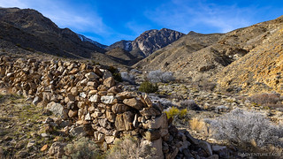
Having traversed several switchbacks in the Tacoma as we climbed to the pit mine, we retraced our path and made one final stop as we exited the canyon. @mrs.turbodb had spotted a cave with her binoculars, and it sure looked like a wall and entrance had been built in the opening!
Definitely not natural.Why live in the perfectly good cabins across the wash when you could suffer here?
Now a little after 10:00am, we pointed the truck downhill and - except for a couple quick photos - made our way back to West Side Road. There, we'd turn north towards Johnson Canyon - a place I'd been wanting to visit since my trip to Panamint City when I'd learned about the "Fresh Vegetable Route."
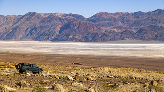
Down we go, the Black Mountains looking sharp on another beautiful morning!
The Mongolian Mine Group, consisting of six contiguous claims, is located on the south side of Galena Canyon about one mile west from its mouth at an elevation of 1,800 feet. The claim group consists of the Mongolian lode mining claim (located 12 April 1928; patented 9 July 1963), the unpatented Mongolian No. 2, and Nos. 3 and 4 lode mining claims (located 10 and 30 October 1973), and the unpatented Mongolian Millsite Nos. 1-2 (located 13 March and 16 July 1976).
Apparently, we'd completely missed visiting the Mongolian Talc Mine, but it looked a lot like the open pits of the Bonny and Mammoth, so we didn't worry too much.
The original claim was located in 1928, but not until the 1960s was a cut opened and the ore determined to be of sufficient quality and quantity to warrant a patent. Little progress in development and lack yet of a strong market for the talc impeded production for the next decade. Pfizer, Inc., began exploratory drilling operations in 1973 and a downdip stripping operation in 1974. This later phase had to be enlarged in late fall and early winter of 1975 because the more easily mined surface talc of the surrounding Galena Canyon mines had played out. The multiple-bench open-pit operation that exists today is the result of an accelerated stripping program that was begun and completed before the moratorium period decreed by Public Law 94-429 had been instituted.Death Valley Historic Research Study
We'd noticed these "ET" trail markers as we'd poked around in Galena Canyon, and a few more along West Side Road. Apparently, they were placed by Leonard Collard as part of an memorial along the old pioneer trail that eventually worked its way over Rogers Pass.
West Side Road was in great shape, and we covered the 5-miles to Johnson Canyon in record time. Heading up the alluvial fan, I couldn't help but admire the desert pavement that stretched out in all directions. Even @mrs.turbodb hopped out of the truck at this point - to do a bit of yoga - while I wandered off for a photo.
By this point - and even though it was still before 11:00am, I was getting hungry. Luckily for me, it wasn't difficult to convince my co-pilot that we should stop for lunch somewhere near the canyon mouth, and twenty minutes later I was hopping around trying to take photos of a rusty old jalopy while the most fabulous turkey sandwiches were being assembled by the chef.
Two rusty beasts.Not often that I see the front axle supported by leaf springs.Incline sunstar.
Soon enough - our bellies much happier for the sustenance (and cake) - we were back on the trail, headed four miles up canyon to Wilson Spring.
As always, the trail got a bit rougher once we entered the canyon.Drawing us in.Cottonwoods at Wilson Spring.
From Wilson Spring, we had only two miles - and 1,000 vertical feet - to reach Hungry Bill's Ranch; a cakewalk as far as most Death Valley hikes are concerned. Usually.
As always, the devil is in the details, and for this particular hike, we had conflicting information from two trusted sources.
... For the next 2 miles, you will be crossing one of the lushest and wettest springs in Death Valley.
There is only one problem, difficult to reconcile with sparsely-vegetated Death Valley: the oasis is so dense that it is almost impenetrable. Unless you like trekking through jungles, you will want to avoid the wash and follow the higher trails along the gorge's rims. These trails are not the most well behaved. Steep and rocky, they tend to split or to sneak back to the creek while you are not paying attention and disappear in a hopeless tangle of brush. It can be a pain; you may even forget you are supposed to be having a good time. To minimize frustration, stay on the south side, which has the most continuous trail system. The exception is the sharp jog in the canyon, where the creek must be crossed twice in close succession. Also, do not take the cairns too seriously: they indiscriminately point to good and bad trails. Even with these pointers in mind it will be slow going.
I must say that it was a very enjoyable hike from [Wilson Spring] on. One thing I liked about it is that there is a well-defined trail to follow the entire way. This trail appears to be visitor maintained, and quite a bit of effort has been made by others to help you stay on the correct path. So, I would like to offer my thanks to anybody who has ever contributed to this trail in the past. The trail leads you up from Wilson Spring through the narrows of Johnson Canyon. It crosses back and forth over the flowing spring once in a while, and helps you avoid the thick brush of the canyon by taking you up high on the hillside, which also means you have great views.
Steve Hall, Hungry Bill's Ranch
Not that any description would have stopped us - I was most definitely going to see the orchards that fed the fresh vegetable route - but both of us were hoping that our experience would be closer to Steve Hall's as we wound our way up the canyon.
A little way up the canyon, we ran into this amazing little arrastra.The canyon narrows.So far, the trail was quite reasonable.We found this rock-lined water trough that seemed to be collecting water off the face of a large rock - for what purpose, we couldn't tell.This little guy picked a pretty spectacular spot.The gurgling of water as it coursed down the canyon added such a nice soundtrack.
Have a listen.
Ultimately, it took us about two hours to cover the two miles to Hungry Bill's Ranch - about average for us when some bozo is always stopping to take pictures of this cactus or that stream. As far as the trail went, I think we'd both agree that it was as easy to follow as any trail through a canyon, and in places where we got slightly off-track, it was easy to pick up the trail again. We saw almost no cairns - which is a good thing, as NPS prefers that they not be constructed to mark the trails.
We've arrived!
Hungry Bill's Ranch, once a green pocket of terraced gardens and orchards, is tied to the discovery of silver in Surprise Canyon, just on the west side of the Panamints from Johnson Canyon. The boom gave birth to Panamint City, a roaring camp that quickly swelled to a population of over 1,000. To satisfy the town's growing need for fresh produce, William Johnson started a ranch a few miles to the east, in the well-watered canyon that now bears his name. In the mid-1870s, Johnson moved in on the Shoshone Indians who then lived in the canyon, built terraces and irrigation channels, and planted gardens of beans, squash, melons, and corn, and a fruit and nut orchard. His harvest was hauled on what is now known as the fresh vegetable route, over the rugged pass to Panamint City. He made a profit on the vegetables, but the trees hardly had a chance to mature before the boom was over. By the spring of 1876 the most promising mines had started to run out. Less than a year later many of the mines had closed down and the population moved out, and Johnson took his business elsewhere.
Some years later, a Shoshone named Hungry Bill took over the abandoned ranch. Hungry Bill was a quiet, 6-foot 4 giant with an insatiable appetite. It has been said that either he, his father, or both, witnessed the struggle of the first white men across Death Valley in 1849. In their younger years, he and his brother Panamint Tom made headlines by making periodic raids as far as Los Angeles to steal horses and provide meat for their tribe. As waves of miners later swamped Death Valley, they established a peaceful relationship with the immigrants. During the glory days of borax mining, they were hired to gather mesquite wood near Furnace Creek to fuel the boiler at Harmony Borax Works. Hungry Bill and Panamint Tom also helped build the road across the salt pan for the 20-mule-team wagons.
The ranch was abandoned soon after Hungry Bill passed away, probably in 1919. Until at least the 1950s his grandson made seasonal trips to the ranch to harvest fruits for his family, who then lived in the valley. Now, after decades of neglect, the few trees that still bear fruit only feed the coyotes.
I really liked this old gate and spent several minutes getting the perfect framing. Of course, in doing so, I forgot to focus. An old walnut tree, slowly being crowded out by the willows.Higher on the hill, the foundation of an old residence or perhaps workshop.Hard to push around without handles or a wheel.
After looking around - and failing to find any fruit or veggies to snack on - it was nearing 3:00pm when we pointed ourselves down canyon for the return trip to the Tacoma. This time - as usually seems to be the case - we covered the two miles much more quickly. In just over an hour we were snacking on the cakes that @mrs.turbodb had so cunningly purchased, and discussing where to find camp for the evening.
A final look up to Panamint Pass - the route Johnson would have taken with his fresh veggies.High clouds were starting to move in, and a soft afternoon light streamed across the hillsides as we reached the truck.On our way back down the canyon, I spotted these large slabs of petrified ripples. I think they are the largest slabs we've ever found.
Not quite sure if we'd head south or north on West Side Road in the morning - we had options in each direction - we decided that the safest bet would be to camp on the alluvial fan overlooking Badwater Basin. That meant that we could reach camp early and bum around for an hour or so before making dinner.
Because who wants to make dinner when it's light, if you can wait until it's dark?
One thing I love about Death Valley - even completely out in the open, the solitude is complete.
Two days - out of three - in the bag, everything seemed to be going to plan. Of course, we hadn't attempted any of the dangerous stuff, yet.
great pictures, we didn't quite make it up to the Ranch as we were running out of day light and we camped at Wilson Spring, we were there on Feb 22nd, what date were you there?
turbodbMarch 12, 2023
Thanks John! We were there Feb 10th, so just a couple weeks before you. (Also, you can always find when a specific story took place by looking at the bottom of the story for the line that says "experienced on [date]"; not that I expect you to have found that, or necessarily remember it in the future ?.)
Camping at Wilson Spring seems nice - did you use the circular area with the fire pit, or were you in your vehicle? (or both!)
JOHN D MORANMarch 13, 2023
Another fine adventure, thanks again for sharing your trips in words and photos.
turbodbMarch 14, 2023
Thanks as always John!
Patty HeroldDecember 26, 2024
In the mid 80s it was possible to drive a 3/4 ton 4am GMC pulling 2 horses in an old bumper pull up to the spring where we camped. We had 2 horses & every day we worked with limb loppers to open the trail to Hungry Bill’s, took a few days but we made it! There were 3 of us; John Chess, Don MacLaughlin & me, Patty! Great fun, great memories! Last time was in '93. Now, 12/26/24, all my exploring on horseback buddies are in the mist. I still explore where I live in Colorado but I miss Death Valley & my friends.🤠
turbodbDecember 27, 2024
Wow, what an awesome story Patty, thanks for sharing it! (And, thanks for all the work on the trail to Hungry Bill's.) I always love it when I hear how a place I've been triggers memories/stories for folks who've been there before me. When you three were up there, was there any more to the property than a few stone walls? Were the orchards still producing any fruit?
Patty HeroldJanuary 15, 2025
Yes, some fruit, mostly the old stone walls & lots of old rusty equipment! Carried out lots of trash, some folks can pack it in
but not out, mystery to me?! Happy Wishes to you. 🤠🙏👍Patty


great pictures, we didn't quite make it up to the Ranch as we were running out of day light and we camped at Wilson Spring, we were there on Feb 22nd, what date were you there?
Thanks John! We were there Feb 10th, so just a couple weeks before you. (Also, you can always find when a specific story took place by looking at the bottom of the story for the line that says "experienced on [date]"; not that I expect you to have found that, or necessarily remember it in the future ?.)
Camping at Wilson Spring seems nice - did you use the circular area with the fire pit, or were you in your vehicle? (or both!)
Another fine adventure, thanks again for sharing your trips in words and photos.
Thanks as always John!
In the mid 80s it was possible to drive a 3/4 ton 4am GMC pulling 2 horses in an old bumper pull up to the spring where we camped. We had 2 horses & every day we worked with limb loppers to open the trail to Hungry Bill’s, took a few days but we made it! There were 3 of us; John Chess, Don MacLaughlin & me, Patty! Great fun, great memories! Last time was in '93. Now, 12/26/24, all my exploring on horseback buddies are in the mist. I still explore where I live in Colorado but I miss Death Valley & my friends.🤠
Wow, what an awesome story Patty, thanks for sharing it! (And, thanks for all the work on the trail to Hungry Bill's.) I always love it when I hear how a place I've been triggers memories/stories for folks who've been there before me. When you three were up there, was there any more to the property than a few stone walls? Were the orchards still producing any fruit?
Yes, some fruit, mostly the old stone walls & lots of old rusty equipment! Carried out lots of trash, some folks can pack it in
but not out, mystery to me?! Happy Wishes to you. 🤠🙏👍Patty