
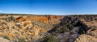
Headed north up Comb Wash, I didn't have far to go - a couple miles perhaps - before I reached the turn off to my next destination. Too, the road here was in great condition, making for quick travel times as I marveled at Comb Ridge through my windshield.
Note: Visiting Comb Wash requires a pass. For more information, check out BLM Utah Cedar Mesa Permits and Passes Information.


Soon, I was on a spur road leading west - not as nicely graded as North Comb Wash, but significantly better than Hotel Rock had been just a day before. I was on my way to the Monarch Cave Ruins - or, what I thought were the Monarch Cave Ruins at the time!
Ahead, the cave loomed large on the hillside; my anticipation grew.

Reaching the end of the spur, I pulled the truck into the shade of a Pinyon Pine and finally settled down for lunch. It had been nearly two hours since my stomach alarm had sounded - way back at the apex of my time in Arch Canyon - and by now the rumbling was enough to make me think I might need earplugs to make it another mile. A tuna sandwich, chips, and plenty of cool water satisfied my midsection and soon I was once again navigating my way up the side of a steep canyon to investigate its bounty.

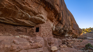
Upon reaching Monarch Cave, I was initially surprised by two aspects of the cave. First - the floor. Covered in a fine powder some four- to six-inches deep, it was a minefield to walk through. Every step would raise a cloud of dust. As a result, my movements became measured and deliberate - each step taken only out of necessity. Second, the complete lack of ruins! This - at the time - was a bit disappointing. I'd been promised ruins, I found myself thinking, selfishly. I caught myself quickly - one should never expect ruins - and turned my attention to the wonder I had before me, because the cave was wondrous!*
* Note: Upon my return, a little research revealed that I was in the wrong location - the cave I explored was the Comb Wash Cave. The Monarch Cave - which I now must return to explore looks similar and is nearby, but I did not hike it!
It was at this point that a third aspect of the cave presented itself. A rhythmic dripping drew me to the back wall. There, from floor to ceiling were several stalagmites! Of all different heights, I could only imagine the centuries needed to build these amazing structures - one drop of water at a time. It was - I realized - even more special than ruins.


My exploration complete, I wondered if perhaps the ruins I'd expected to find were nearby in the canyon. I searched for 10 minutes or so - obviously finding nothing, since I was in entirely the wrong place - before heading back to the Tacoma and south along Comb Wash.

While I'd continue to follow Comb Ridge for much of the afternoon, I first decided to take a short detour as I reached UT-95. Here, I headed west - just a few miles - to a two-mile long road heading south. This road, as one may have - at this point - presumed, led to ruins.
Cave Towers (also known as Seven Towers) is an Ancestral Puebloan site dating to the mid-1200s - the late Pueblo III period. It consists primarily of seven masonry structures built around a canyon head. Some of these structures were believed to be towers, while others were likely above-ground kivas. The arrangement intuitively appears to be in defense of a natural spring coming out of the rock below the structures. -State of Utah informational sign
I followed a well-marked trail around the site, pausing at the towers, some of them in better condition than others.


As I wandered, my eyes peeled, I noticed that the towers weren't the only ruins in the area - in fact, there were a series of cliff dwellings amongst the head of the canyon that looked even more intriguing to investigate.
Just as I was about to set out, I found myself wondering - "Why aren't these mentioned in any of the signage?" It was then that I realized that by focusing attention on the towers, the powers that be were deflecting attention from what are - perhaps - more fragile specimens. And so, a bit reluctantly, I reeled myself in and headed back the way I'd come. After all, it's not like I was going to be short on ruins this trip!
Retracing my steps along UT-95, I soon found myself descending the grade into Comb Wash, the entire length of Comb Ridge stretching out before me.

A few minutes later, I turned south - now on South Comb Wash towards, well, the south. The road was wide an smooth. After a quick photo with the ridge stretching out next to me, it was easy to maintain a speed of 50mph - orange dust rising up in my wake.

I maintained that 50mph for the better part of half an hour before stopping again; perhaps my longest uninterrupted run of the entire trip. Comb Ridge was majestic the entire time, providing visual interest in both its profile - as well as my search for ruins - as I sped along its base.

Eventually I'd reach the southern tip of Comb Ridge, but not today. Today, I had one more set of ruins to visit - Moonhouse, several miles to the west. First however, I decided to check out an old homestead ruining away in the valley. There wasn't much left - and even less on the inside - but it was heated at one time, so likely used year-round for some agricultural purpose.


Not long after the homestead, Snow Flat Road split off to my right. Nicely graded - for the most part - as well, I followed it for the better part of 15 miles. Climbing up onto what I can only assume is Snow Flat, the landscape was as orange as ever, the La Sal Mountains serving as an omnipresent landmark to the north.


I arrived at the parking area for the Moonhouse ruins just before 5:00pm. It was deja-vu all over again - I'd set off at about this time the previous evening for Hotel Rock! Tonight however, my hike was significantly shorter - some three miles round trip - and I figured no headlamp was necessary as I gathered up camera equipment for the relatively short hike to the ruins.
Note: Visiting Moonhouse requires a permit, and it's day use only. A maximum of 20 permits per day are issued on a first come, first-served basis. From March 1 through June 15 and September 1 through October 31 (high use seasons), 12 of the 20 spaces are available to reserve at the Cedar Mesa and Bears Ears National Monument Permits Recreation.gov page at least five days but no more than 90 days in advance of the entry date. The eight remaining spaces may not be reserved in advance and are only available by walk-in at the Kane Gulch Ranger Station on the morning of the hike. Permit fees are $5 per person during the high use seasons, including a $6 transaction fee for reservations. All permits (including reserved permits) must be picked-up in person at the Kane Gulch Ranger Station during the high use season. The maximum group size is 12 people.
From June 16 through August 31 and November 1 through February 28 (low use seasons), Moon House permits must be reserved at the Cedar Mesa and Bears Ears National Monument Permits Recreation.gov page before arrival.
For more information, check out BLM Utah Cedar Mesa Permits and Passes Information.
I had no idea at the time - frankly because I hadn't paid much attention when scouting the route - that I was in for several thousand feet of elevation gain, as I completely descended one side of the nearly vertical canyon before nearly ascending the - again nearly vertical - other side!
Not that I'm complaining. Not by a long shot.


As I completed the final 30-vertical feet or so to Moonhouse, I had a decision to make: should I start here - at the main ruin - or should I investigate a nearby kiva, first? Ultimately I decided to save the best for last, and I continued the additional half-mile or so to the kiva.

Made of a couple of structures, this kiva was the first time I'd seen a wall built inside the outer wall. Recesses and openings Holes in the inner wall appeared to be a place to store things - perhaps used in the rituals - and the walls themselves were entirely covered in mud and extremely well finished.


Excited more than ever to check out Moon House, I quickly made my way back to the enormous - and well-preserved - ruin I'd come all this way for. Even from across the canyon, I'd noticed that there were several multi-colored pictographs, one of which I quickly made a beeline for upon my arrival.

Some of the structures here were totally perplexing - what could the purpose of these wooden rafters have been?

Others were much more traditional - though even the traditional structures had a level of finish that I'd not seen before.


Finally, it was time to check out the main structure. It was by far the largest ruin I'd ever seen at more than 60 feet long, and it was initially unclear how the Puebloans had gained access.

Eventually however, I found the exterior door and made my way in. And that's when I knew I was somewhere really special. I'd expected - as with every other ruin I've visited - to look in the door and see the rock wall of the canyon angling down toward the floor; some rocks, rat scat, and perhaps a few stones scattered about. Here, I saw nothing of the sort. Rather, it was like entering an underground city street, the outer wall providing protection from the wind and rain for an entire community living inside.


Not only did the exterior wall provide protection from the elements, it also contained 27 "loop holes." These holes provided line of sight coverage of all angles of canyon access, the main ledge in front of the ruin and part of the canyon bottom. Common in many late period (late 1200s) structures on Cedar Mesa as well as the northern Colorado Plateau, current theories suggest that these holes may have served a defensive function as visitors approached settlement.


Needless to say, I'd been blown away by Moonhouse. Having explored it for nearly an hour, I felt like I'd seen nearly everything and yet could continue to discover details for several more. Unfortunately, with sunset on the way - and 1500 feet of canyon to climb - it was time to get going.
Luckily, on my drive to Moonhouse, I'd spotted - and marked - a camp site that I thought would be an ideal place to wake up in the morning. Five miles away from the parking area, I nearly made it without having to turn on my lights - the lengthening days of spring a nice change from the 4:30pm sunsets of winter!

My usual routine followed - dinner, a quick wash of my face and legs after a dusty day of hiking, and a few minutes transferring photos - before I extinguished the lights and fell asleep to a brilliant moon rising in the east. I felt redeemed after my experience with Lewis Lodge the day before, but I already had a plan brewing in my mind.
A plan - unbeknownst to me - destined for failure.
But a recovery that would lead to redemption, eventually.


While at the Moonhouse, I read through a packet of information stored in an ammo can at the site. I felt like these several paragraphs were worth sharing, but didn't know where to put them in the actual story:
Another excellent adventure and photos and your stories are the best. I will have to try and see of these when I do the Mighty 5 later this year.
I'll not be missing all these amazing ruins when I go back! I'll do exactly as you have, and start at the southern end of Butler Wash, spend a couple of days exploring, then take the Comb Wash from its northern end to the southern terminus, and again spend a couple of days. Thanks for inspiring me to get back there!
As I started reading this one I was wondering to myself why you were headed north to reach Monarch Cave? ...and then I got to your note!
Yeah, I'm not sure how I incorrectly marked/identified the cave in my initial research, but at the end of the day, that's just part of the adventure. I may never have visited this cave otherwise, and the stalagmites it contained were totally worth seeing!
Always enjoy these virtual trips you're taking me on. I have fallen behind a little bit, but I do have a life. lol Thanks again for an entertaining, beautiful trek through this great land. I cannot get enough. Stories beautifully done as well. Almost.....ALMOST....as good as being there......but I can't help but think, What a bitchin great way to live life!!! Wish I had thought of it 30 yrs ago. lol keep on keeping on.......Jeannie.
Thanks Jeannie, I'm glad you're enjoying. Falling behind just means you can binge-read to catch up ? ?!