
After grabbing lunch in Eagle, we hopped on the freeway - a slightly embarrassing experience, given that we were aired down and travelling rather slowly - for the six-mile stint back to Gypsum and the start of Stage 5. In fact, we'd be splitting off from the main route, which follows the highway for a stretch, opting instead to run the 15-mile "Harder Alternate," rejoining the main route at the Colorado Canyon Gorge.

"No Jimmy, the fish wasn't 'this big,' it was only four fingers long." Gypsum, keeping it real.
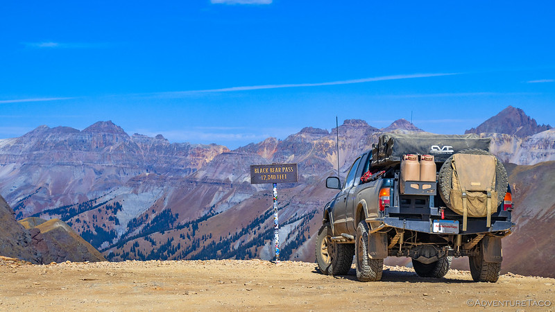
Stage 5 - Gypsum to Steamboat Springs
North of Gypsum are the Flat Tops. Well, technically, immediately north of Gypsum is the big gypsum mine, but with a we-only-accept-private-leer-jets airport just across the freeway, I wasn't able to fly the drone to capture some epic pit-mine shots. Imagine layers of deconstructed sheetrock, and you're 90% of the way there.
So, the Flat Tops. That's where we were - on a volcanic plateau formed by basalt lava flows during the Tertiary period, which were later uplifted and eroded by glacial activity - when our little buddy informed us that taking off was against federal law.
The area’s elevation ranges from about 8,000 to over 12,000 feet - a result of the volcanic layering and glacial carving - with the highest points capped by resistant basalt that eroded into dramatic escarpments.
As the road wound its way though a drainage, it was hard to get a sense of scale from our position. By now though, we were far enough from the airport that our little buddy could pop up overhead to capture the sloped surface, slowly eroded into badlands.

This stretch of the route was reminiscent of parts of the San Rafael Swell, and of Anza Borrego.

Working our way along this stretch of road was like slaloming down the valley.
The landscape here was a mix of alpine tundra, pinion and juniper forests, and wide-open meadows, transitioning quickly from one to the next as we gained and lost elevation. What sets this area apart from the other Colorado mountain ranges we'd visited was not a proliferation of rugged peaks, but rather a collection of flat-topped volcanic plateaus that rose abruptly above deep valleys and forested slopes. The central geographic motif here was the mesa.

Pinyon pine and juniper covered the rolling hills, and clouds rolled by overhead.

Nice light on the layers of gypsum.
Fifteen miles of dirt goes quick when you're covering 150 or more miles per day. Twenty minutes after hoping for some excitement as we pointed ourselves up the alternate route, we turned onto the pavement - the main Backcountry Discovery Route (BDR)- just as it was entering the Colorado River Gorge. The alternate had been dirt, but I think it was being more than generous to suggest that it was "Hard."

The mighty Colorado.

That seems like a fun - and beautiful - ride!

Little Buddy! Hard at work for much of this BDR.
We followed the Colorado River Gorge for nearly two hours. Here, the Colorado River carves a narrow, shallow canyon through late Cretaceous and Paleogene sedimentary layers. The riverbed - which sits atop soft Mancos Shale and Dakota Sandstone - is interrupted by occasional limestone beds from the Eagle Valley Evaporite, which forms small ledges and riffles. Still, the gradient through this stretch of the Colorado is gentle, creating a series of cobble-lined riffles and Class II rapids as the river drops only 100 - 150 feet over three miles.

There were numerous rafters and fishermen floating what seemed like the very tame stretch of the Colorado that we experienced.

A lot of oil.

Signs said that this was the headwaters of the Colorado. We're not so sure.
It was 3:30pm as we climbed out of the valley and left the "headwaters" of the Colorado in our rear-view mirror. Too early to camp, it was apparent that we were - once again - going to have the same where-to-camp problem we'd had on previous stages. With only 30 miles to the end of Stage 5 at Steamboat Springs, we were going to need to find a spot nearby to camp, or push well into the final stage before calling it a night.

Goodbye Colorado River.
Ultimately, we opted to push on, since stopping so early in the afternoon - in temperatures that were toasty outside the air-conditioned cab - seemed like a waste of time. Plus, I had a couple of things I was looking forward to in Steamboat Springs. First, meeting up with Brett @Squeaky Penguin, to say hi and pick up a broken CV axle he was kind enough to give me and had been holding onto for a couple years; second, for some tasty treats at Taco Cabo, a place Brett had taken us the last time we'd been through on our Redhead Down trip several years earlier.
So, I texted Brett to let him know when we'd be in town, and we pushed on.

A nice water crossing to play in.


Rock Creek Stage Station. Built around 1880, this building served as the James P and Katherine Lemley Gates family home, a hotel for travelers, a post office, and stage stop. At one time it was also used as the election polling place for the nearby town of Toponas. (info sign)

Approaching Steamboat Springs, the houses - which @mrs.turbodb began referring to as "little chalets" - started to get... more luxurious.
We pulled into Taco Cabo right around 5:30pm, and soon we were seated along the water's edge enjoying carne asada and chicken nachos.

Good, but not as tasty as the tacos.
Unfortunately, while we were eating, I got a text from Brett - on his way home from a trip to Yellowstone and Grand Tetons - letting us know that he wouldn't be home until closer to 8:00pm, a couple hours after we'd left Steamboat. This was a bummer - he and I always seem to miss each other - but I suppose that having fun on an adventure is one of the best reasons to miss each other. Still, that dude is awesome, and he suggested that I just wander into his garage to pick up the CV while we were in town!

Thanks Brett!

Headed out of (second?) town.
Stage 6 - Steamboat Springs to Wyoming
After texting Brett that I'd retrieved the CV and tried to contain the greasy mess that resulted in my cutting off the two ends - the only bits I needed to make some trail spares should one of my CVs ever break - he wished us safe travels and warned us that there wasn't much public land north of town. This was something we already had a sense of, but we still hoped we could find some little pullout or spur road to call home for the night.
We forgot - or perhaps didn't realize - that where the chalets are super-sized, the owners are quite particular about hooligans hanging around.

The light as we headed out of town was fantastic.

Golden glow.

Oh, you only have one big plane? You sir are a peasant.

In the end, we had to drive more than an hour - well into darkness and through half of the final stage - before reaching a road that led us onto public land in the Routt National Forest. Finding a fire ring on what seemed to be a short spur, we leveled the truck and popped up the tent. We didn't think much of the location at the time.

Our last night.
Nestled into the trees, we slept reasonably well, though it was louder than I'd have expected out here in the middle of large plots of private land along the northern edge of Colorado. Still, with ear plugs engaged, I felt refreshed when my alarm went off just before sunrise, and soon our little buddy was scouting around camp, looking for the perfect angle.

Behold, as far as the eye can see, private land!
It turned out that there were no fantastic views on our final morning in camp - at least compared to previous mornings - but as I was clumsily flying the drone around in search of the something worth taking a photo of, I spotted what appeared to be a waste rock pile and a hole in the side of the mountain! And then, as I pointed the joysticks one way and then the other, I noticed that the little spur road we'd camped on was in fact an old mining road. One that climbed 500 feet up the mountain behind us to a very intriguing adit!
Suddenly, things were getting interesting!

As we hiked up the old road, I found this very expensive looking piece of worthless ore.

What have we here? Door's open, please come in!
The Greenville Mine - also known historically as the Greenville Shaft or Tom Thumb Mine - is located just east of Clark at about 7,800 feet elevation. A lead, zinc, gold, silver, copper mine, it was first worked in the early 1900s and consists of three - now gated - adits along with several prospects.
The mine’s principal production came during World War II, when it yielded roughly 1,600 tons of ore. The ore occurred in lenses of calc‑silicate schist with quartz, sphalerite, pyrite, galena, and chalcopyrite. After the war, activity wound down, and the site was abandoned,

Colorful chamber.
After poking around for a bit - I even got @mrs.turbodb to wander into the adit for a few minutes to admire the colors - we headed back down to camp for breakfast. Following our usual pattern, I put away the tent while the tailgate was used to amass our cereal, milk, and fresh blueberries, all of which were promptly disposed of in a matter of moments. Then, as my companion set about putting everything away again, I wandered around the site picking up after those who came before us.

I'm never happy that people leave this shit all over the ground. It's irresponsible use of our Public Land that leads to us losing the ability to enjoy it!
After weighing down the Trasharoo with our pile of recycling, we retraced our path to the main road, and immediately found ourselves in the town of Clark, Colorado. Or on the outskirts of it. Or something.

Is it even a town if the population is questionable?
As they had been - and would be - for the last 150 miles, the roads in this neck of the woods were smooth and fast. They have to be if you're to reach your tiny chalet in your low-clearance roadster. This made our travel easy, and we found ourselves adopting various accents as we discussed the posh properties along the sides of the road.

Dear me old chap, do you really think we've taken full advantage of this corner lot to show off our wealth?

Yes, yes I did have them pre-patina my private Skyote Airport sign. Who has the time to wait for nature?
The further north we went, the larger the properties became. Here, fences were no longer the name of the game; entire groves of aspen were used to shield one property from the next. Here, private lakes and streams were the norm, so it was strange to see a man casting his fly rod into a grassy field. "Just practicing, chaps," we imagined him saying, had he any reason to even notice our confused looks as we - gasp - drove ourselves by in our peasant-mobile.

Property boundaries that look spectacular in the fall.

I do always love the aspen bark.
Far and away the most expansive property we encountered was the Three Forks Ranch. Coming around a corner, we couldn't help but notice the largest home we'd seen so far. Or, according to the Three Forks folks, just a "cabin for large groups."
The Cardinal Lodge is the perfect family home away from home. Remodeled in 2019, it has a refreshing charm and an air of luxury. As it is located on a ridge, it has incredible views from its large decks. Secluded from the Main Lodge, it gives guests both privacy and freedom. It contains six bedrooms, all with en-suite bathrooms, two powder rooms, a theatre, a lovely living space, and a dining area. Its large kitchen is fully equipped and includes a private chef and staff to look after its occupants in style! The lodge sleeps 12 comfortably.Three Forks Ranch
Of course, the joke was on us. Not knowing it was a resort, we rattled off several cow jokes as we continued at high speeds along their fabulously oiled roads. "We certainly can't have any dust on our ranch, good chap." And then, we crested the next hill.
With fewer rooms [there are only 16 rooms] in our Main Lodge, we prioritize personalized attention to ensure every guest receives exceptional service. Whether you’re planning a weekend getaway or celebrating a special occasion with loved ones, our limited accommodations allow our dedicated staff to cater to your needs with unparalleled care and attention to detail.
The main lodge. You know, with "fewer rooms."
Three Forks Ranch

It wasn't until we got home and @mrs.turbodb had a chance to look the place up that we got a full sense of the opulence. At Three Forks, they have their own ski slopes, but those slopes have no lifts. Why would you need lifts when every skier is accompanied by their own heated snowcat to return them to the top of the mountain when their run is done. It is, after all, the "One and only destination where grooming is curated to skier ability."
And hey, rates start at only $4,200/night with a three-night minimum! 
So yeah, we weren't going to be staying at Three Forks any time soon, unless it was the one in Owyhee Canyonlands, which is more our speed anyway.
A few minutes later, we were racing along the Wyoming border, only a few miles from the end of the Colorado BDR.

Winding our way along the Little Snake River, we crossed between CO and WY several times.

End of the route!
At 9:54am, we started airing up our tires for the long drive home. We'd end up traversing five states - CO, WY, UT, ID, and OR - over the course of the day as we pushed northwest, the Tacoma transitioning nicely from trail machine to pavement pounder. Along the way we'd stop only a few times for lunch, dinner, and fuel, opting to put as many miles as possible behind us as quickly as we could.
It'd been a beautiful and fast - our fastest to date, I think - BDR, and just as we were pulling away, a group of four ADV riders pulled onto the trail, headed in the opposite direction. Boy, were they going to have a great time!

Enjoy yourselves!
The Whole Story


hello,
for us it was kind of a boring stage.Your pictures are capturing the essence of this stage; many nice land behind gates .This is also Colorado.We are far from the Buena Vista Skibums, Big trophy homes and big fences. We did camp at the same location because there was nothing else for about 50 milles
Again your give us somes nices pictures and a good text and this episode is very enjoyable. thank you
i am rereading my comment like i should have done. The BDR route was boring not your story. I enjoy very much your story.
I am a hothead when speaking about public land access.
No worries, I totally understood your comment about boring and the BDR. I agree that these segments were less interesting than the southern segments. That's largely due - I think - to land ownership differences in the north and south parts of the route.
As always, glad you enjoyed the story! (And, how cool that we ended up camping in the same place!)
Dear Turbodb et al,
As usual, I thoroughly enjoyed this post -- a wonderful combination of beauty, humor, and useful information (I now know what an adit is, as well as a Trasharoo!) Inspired in no small part by your adventures, earlier this year I acquired my own Taco, a 2023 TRD Offroad. Recently returned from a little jaunt to Santa Fe, NM and Bluff, UT. My Taco, which I have named in honor of my five year old grandson ("Spidy JD"), was so comfortable and so much fun to drive, especially on the Forest Roads north of the Bears Ears on a visit to Wooden Shoe Canyon and The Doll House (See "Unfinished Business -- A Little Rock Art Excursion" in the Rock Art Blog section of http://www.mccuration.com). Anyway, Thanks for letting me peek under your tent and vicariously enjoy another of your adventures. Warmest Regards and Best Wishes, Tom McC
PS - I live on a lake in Central Texas (Lake McQueeney, The Water Ski Capitol of Texas} that has been dry for 3 years as we rebuild our dam and, inspired by your drone footage, I purchased a cheapo drone (DJI MINI 4K) to hopefully take videos of the dry lake before they begin filling it with water again later this year!
As always, great to hear from you, and that you enjoyed the story Tom. Glad you got out to the Doll House (I'm off to read your trip report here as soon as I post this); it's a place I really enjoyed almost a decade ago now, and need to get back to!
And the drone idea sounds like a great one; that should be an awesome timelapse!
Great ride along guys!! Lets meet up at that lodge next year! LOL!!
Sounds great! We'll let them know, "We're with Bill," and I'm sure they'll show us to the (second) nicest room!
Glad you enjoyed! 👍
Oh, forgot to mention, making them in your name......