For much of my childhood, summers were spent in the Plumas National Forest. I have such fond memories of waking up in our favorite campground, earning Junior Ranger patches, and fishing in creeks recently stocked with so many fish that the stream bed was obscured by wriggling tails.
And yet, when out exploring as an adult, I've spent almost no time in the Sierra, much less the Plumas National Forest. So, it was with great anticipation that we set out to wind our way through on the Plumas National Forest Backcountry Discovery Trail. Like a BDR, we figured this would be a great way to get a lay of the land and see a few interesting spots along the way - hopefully setting the foundation for future trips to the area.
Having headed south on a Monday morning, it was midnight - under a star-filled, moonless sky - when we set up the tent on a hilltop just outside La Porte, California where the first downhill ski race in Plumas County was held in 1858 (according to a plaque we found the next morning). Temperatures were pleasant - in the mid-50's °F - and soon we were snoozing away.
For a random spot in the dark, we had a nice view the following morning.
Having gotten to bed late, a 5:30am sunrise wasn't in the cards, and we finally shuffled our way out of the tent a little more than two hours later. The trails were calling, and having had huge burritos for dinner, we decided that breakfast could wait.
Less than half a mile from the spur to our hilltop, the welcome sign to La Porte and the beginning of the Plumas National Forest Backcountry Discovery Trail (BDT).
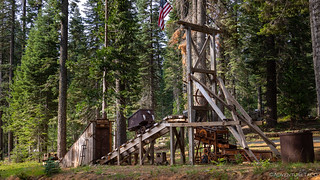
Heading through town - a sum total of a few hundred feet of pavement - we stopped long enough to investigate a reconstructed gold mining display along main street. Composed of pieces found in the surrounding hills, it was one of the coolest reconstructions I've seen in my explorations. I spent several minutes poking around, while @mrs.turbodb read a bit more about the route in a Plumas NF BDT pamphlet provided by the Forest Service.
A staged display, but still fun to look at and representative of the components of a mine.An old monitor. Much of the mining in this region was hydraulic, with entire hillsides washed away with plentiful water.At times, drilling and blasting were necessary, but even so, water was used to power the hydraulic drills.
The Plumas NF BDT travels from south to north for 146 miles of the main route and 71 miles of alternate routes that are best travelled with a 4WD vehicle. Beginning in the town of La Porte, the route winds its way to CA-89 near Lake Almanor or can be extended by continuing onto the Lassen NF BDT.
Split into seven main sections, an optional (out-and-back) eighth section can be added to the beginning in order to reach the southern edge of the Plumas NF at Poker Flat.
La Porte - Poker Flat (Alt.)
Partially because it is out-and-back, but also because it is the most technical segment of the BDT, the route to Poker Flat is considered to be an "optional" section in the BDT guide. I assure you, it is worth spending 4-6 hours on this section of trail. It winds through some fantastic history - and history in the making - along its 32 miles.
Finding our way onto dirt, we covered the first 4.5 miles quickly; the mildly-technical-when-dry-but-sloppy-when-wet section wouldn't come until mile 12. By 9:15am we were at Slate Creek where we got a look at the St. Louis Bridge. Built in 1913, it is thought to be one of the first reinforced concrete bridges in Plumas County, replacing a suspension bridge built in 1865.
While a newer bridge now handles traffic, the St. Louis Bridge still appeared to be in serviceable condition.
A few hundred feet away, we found the Eureka Tunnel. Bored through a granite ridge in 1868, it enabled miners to sluice the tailings - some 40-50-feet deep - that'd run off of the hydraulic mining operations further upstream.
Eureka Tunnel now empties into a pool that's still connected to Slate Creek.Well, we're definitely going to need to check this out more closely.@mrs.turbodb was content to "stay out, stay alive," but luckily I was able to convince her to climb the polished, ultra-slick, granite chute to walk through the tunnel with me.There've been a few cave-ins over the last 150 years, but the tunnel was in remarkably good shape.
We spent a good half-hour exploring this first stop along our way, and I realized that if we hoped to cover all the ground I planned for this first day of our adventure, we needed to get a move on. Of course, looking back now, it's clear that looking around was exactly the right thing to be doing - it was the planning that was the problem.
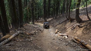
Climbing up and away from Slate Creek, the forest and waterway were looking fine.
Winding our way east was intriguing. So often, we're used to exploring old mine sites in places like Death Valley National Park, or the high desert of Nevada. There, a lack of rain, snow, and trees tend to help preserve structures and make identification of tailings piles, easy. Here, in the forest, grasses, shrubs, and trees have begun to reclaim the land, but if you know what you're looking for, the evidence of mining is everywhere.
In places, the road dodged massive piles of rocks, all that was left of the hillside which once covered this ground, washed away by monitors.More rocks, and the scarred hillside from which they came.There are still people working the land to this day, and signs posted everywhere that prohibit prospecting by those without active claims. Gold Fever is alive and well.
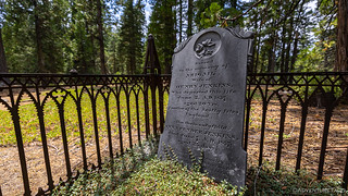
Another couple miles - and another half our - behind us, we found the old St. Louis Cemetery, all that is left of a town that once contained 900 miners and their families from Wales, Portugal, and England.
A stone-lined path ushered us through the forest.I very much liked the ground covering, and shape of this headstone.A mother and her 25-day-old daughter, who survived only five days once her mom was gone.
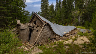
From the St. Louis Cemetery, we covered nearly six miles - the longest, uninterrupted distance so far - before reaching the historic townsite of Howland Flat. Founded in 1850 after gold was discovered in nearby Cold Canyon, its 1,500 people made it one of the larger communities in the area, including several stores, a mix of restaurants and hotels, saloons, a theater, a bakery, and two breweries.
The remains of the original Wells Fargo Express building; the steel door frame of the vault still stands.This cabin has been adopted by a more modern crowd, used in the winter for snowmobiling and perhaps year-round for hunting.The most interesting aspect of the adopted cabin was that one entire side was clad in old tin cans that'd been unrolled and nailed on as shingles.On the edge of a meadow, surrounded by springtime.Spring daisies.Spring checkerbloom.I really liked the shape of the roofline on this collapsed cabin. It won't be many more winters until it's completely on the ground.
Not far outside the townsite, Howland Flat had a cemetery of its own. Rising on a hillside next to the road, there were more people - or at least headstones - here than we'd seen in St. Louis. Quite a bit of work had gone into restoration as well.
These fences are not original, but are not new, either.Maurice M. Moriarty was 63 years old when he died in 1895.Daniel McKeever was the oldest headstone we found - 1882.
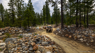
Even with all the looking around, we made good time and it was right around 11:00am when we started down the final four miles of the road to Poker Flat. This is the only semi-technical portion of the trail, and while it can probably get sloppy when it's wet, good tires, a careful line, and a (stock) high-clearance 4WD are really all that's needed to get down this trail.
The best kind of sign.A relatively smooth - but steeper than it looks - section of the descent. The first vehicle down for the year would likely benefit heavily from a chainsaw. A few places get a little rough and rocky.Poker Flat Creek had a good flow, but was not very deep.
We reached the bottom just before noon, and after poking around Poker Flat - checking out another active mine as well as a few old ruins - we found a little spot in the shade where we could break out the kitchen to make our breakfast... err, lunch.
While @mrs.turbodb piled deli meat into tasty sandwiches, I explored the last remaining cabin ruins on the meadow.
The town of Poker Flat had its beginnings in the early 1850's. It is reported that only twelve families were living in the camp of Poker Flat in 1856, but 400 miners lived within two miles. Henry Cohn, who had a store here 1857 to 1863, described Poker Flat as a "miserable hole." The town, like most early California mining towns, burned down in 1859 and again in 1876.USFS Information Sign
The only "problem" with lunch at Poker Flat was that I'd planned for us to be eating lunch near Quincy, after completing another couple segments of the BDR. Normally it wouldn't have been any sort of issue at all, but in this case, we'd hoped to meet up with a couple of my aunts and uncles who live in the area. Clearly, that wasn't in the cards, my time-estimation skills failing me yet again.
A slow learner, I figured we'd probably arrive mid-afternoon (spoiler: we wouldn't), as we got everything piled back into the bed of the truck and took off up the rocky road.
We made it about 100 feet or so when I heard it. The hissing sound was unmistakable, and rolling down my window confirmed it - air was leaking out of the driver front tire. Fast!
My first flat on a Cooper ST/Maxx. Or is it?
Rolling back down to flat ground, it didn't take long to pull off the hi-lift, jack up the Tacoma, and swap in the spare. And it was then that I noticed what the problem really was: I'd snapped off the valve stem!
The hi-lift really is a great tool, as long as you know how to use it before you get in a situation where you need to use it.A freak accident.
Everything was buttoned back up in less than 20 minutes, and we headed up the trail again. We were lucky enough to get a second chance, but we weren't going to get a third, so I paid careful attention to my line to avoid any possibility of another incident. Of course, there was no incident, and soon we'd put the four-mile climb behind us and were bombing down the relatively smooth Forest Service Road that we'd traversed earlier in the day.
It was a little after 2:00pm when we arrived back at La Porte, ready to kick off the official route.
La Porte - Harrison Flat (Section 1)
Finally starting to admit that we'd be lucky to make it to see my relatives by the end of the day, we started looking for service on our cell phones in order to let them know that we were running a tad late. Naturally, service was non-existent for several more hours, as we continued through the woods.
Having grown up here, I do love the variety and height of forests of the Sierra.
Our first stop was at Gibsonville - another town from the mid-1800s with a population similar to that of those we'd explored earlier. Like those, only the cemetery remains today, and having seen two already, we opted to skip a detailed investigation in favor of a futile attempt to get back on schedule.
Seriously, I never learn.
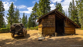
Ten miles into the 19 mile section, we stopped at the Sawmill Ridge Warming Hut. There wasn't much to see here, though I'm sure it's a welcome shelter in the winter when fingers are cold and bellies are empty.
You'd think there might be a door...If I had to guess, this wood heat stove was made by a local in the 1980s. Should have gone with Feather River Stove Works, if you ask me.
At this point - with the track following reasonably good roads - the miles were passing quickly, though photo opportunities seemed to jump out at around every turn. Lakes, peaks, waterfalls, and all manner of views were the reason we'd gotten off schedule, but we continued to stop on a regular basis to soak them all in.
Pilot Lake was looking nice.We found a fantastic camp site with a view, if only it'd been time to stop for the day. Only later did we discover that we'd been looking at a Fire Lookout at the top of Pilot Peak, which we could have visited, putting us even further behind schedule.This two-level waterfall and sunstar aren't going to last all summer.
Millions of years ago, an ocean covered the area now known as the Sierra Nevada. Beneath the sea floor, geological processes were at work that would lead to the formation of the Sierra Nevada mountain range. Natural forces, like plate tectonics, volcanic activity, erosion and weather played a role in shaping the material underlying the Plumas National Forest.
Once the mountains were in place, glaciers shaped the landscape. The weight of the glaciers and the power of the streams of melted ice carved out canyons, stream channels and valleys. The Sierra Nevada is considered to be relatively young and active, which means that they are still being altered by the shifting of the earth’s tectonic plates.
Did you know that these large, solitary boulders left by glaciers are called "erratics?"
As we transitioned to the second section of the route, it was a little after 4:00pm. We'd certainly made better time that we had in the morning, but with all the stops for photos, we weren't going to win any awards for efficiency. Also, it was looking like our plan - there's that word again - to complete three-or-maybe-four stages before finding camp for the night was probably unlikely to happen.
After a quick discussion, we decided that the best course of action was to get through one more section and then make a 15-mile detour into Quincy in order to attempt a repair on the valve stem, just in case we needed that tire as a spare later in the trip (spooky foreshadowing). We also got cell service for a few moments and made a call to let my favorite #1 uncle know that we weren't going to be showing up for lunch, but might arrive a bit after dinner.
The views in section 2 continued to impress, but we did a better job of staying focused on our goal.
We didn't stop as much as we raced through the alpine scenery, eventually transitioning from green forests to a landscape charred by the Cold Fire. It helped - significantly - knowing that the Les Schwab in Quincy closed at 6:00pm, and that we'd probably roll in around 5:50pm if we made really good time.
The Cold Fire was started by lightning. In 15 days, more than 5,500 acres burned. Amid the dead tree trunks, the post-fire regrowth has begun with grasses and shrubs.At the edge of the woods, cabins and civilization - among other things crept into view.
Miraculously, we arrived in Quincy at 5:45pm and rolled into the parking lot at Curran Les Schawb Tire Center. Almost before we'd gotten out of the truck, two young dudes came out to greet us, and I gave a brief rundown about the valve stem.
"No problem," they said, "we got this."
Highly recommended. Great Service.
After pulling the spare off the rear bumper - which we had a fun chat about, as it turns out that one of the guys had an Imperial Jade 1st gen Tacoma parked on the other side of the lot - it wasn't more than a few minutes before they had it re-stemmed and ready to go back into service. And, when I asked what I owed them, the price was perfect... "Don't worry about it." Dang, that's cool!
That's a nice truck you got there!
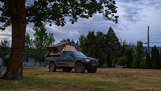
Ten minutes later, in time to make dinner in the front yard, we pulled onto the lawn at my uncle's house to big grins and warm welcomes. What with COVID and whatnot, it's been three or four years since we've seen each other, so it was nice to catch up over a dinner eaten outside. We chatted into the evening, eventually setting up the tent when the sun hit the horizon.
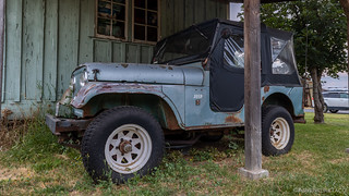
I have fond memories of this Jeep, which is the first vehicle I ever drove off-road. The thing my Uncle and I *both* remember most about that day was when I got behind the wheel and he looked over and said, "If I yell at you, I'm not mad. It just means I want to live." Easiest night ever leveling the tent.
It'd been a long day and we'd made less progress than we'd expected. It was enough to worry us a little bit - we didn't have all that many days to finish the route before we needed to high-tail it home. Plus, I already knew that the next couple of legs would be a challenge. Not because the trails were hard, but because it would pass through what was perhaps my favorite place in the world.
Very nice trip. Reminds me of way back when we went into the back country around Lake Tahoe on logging roads. Hey, those plants in the little green house looked like pot!
turbodbAugust 28, 2022
Those little green plants sure did, didn't they? hahahaha ?. @mrs.turbodb was like, "Are you seriously going to back up and take a picture of that? Let's get out of here!"
Trish BrownAugust 29, 2022
Once again great writing and story. I also enjoyed your Wyoming BDR adventure. I lived in Saratoga Wyoming and have spent many days driving around the mountains in the Sierra Madre and the Snowies, as we call them. I went to college in Laramie. Anywho, glad you liked the route. My husband and I live in Colorado now but are thinking of doing part of the Wyoming BDR on our motorcycles. If you could only do 4 or 5 days what part would you recommend?
Keep up the good work. I'm living vicariously through you all and your adventures as I slog away at work.
turbodbAugust 29, 2022
Hi Trish,
Personally, my favorite parts of the Wyoming BDR were from Baggs to Elk Mountain (The Sierra Madre and Snowies - stage 1 and stage 2 - with stage 2 being better than 1) and then the last couple segments in the Bighorns (stage 7 and stage 8 - with stage 7 being better than 8) - starting in either Ten Sleep or for a bit longer ride and completely different terrain, Shoshoni.
As far as difficulty goes - though I know you didn't ask ? - the former (Baggs to Elk Mountain) would be easier on motorcycles.
And of course, there's always the option of doing both in 5 days. I think a 2-day ride from Baggs (or Centennial) to Elk Mountain, then a 1-day highway ride up WY-487, I-25, and US-16 would get you two days in Bighorns, beginning around Meadowlark Lake. That's probably how I'd do it ?.
Hope that helps, and glad you've enjoyed the story. It's always nice to hear when it gets someone else thinking about getting out there!
Cheers,
Dan
KeithSeptember 21, 2022
Fun you are in my neck of the woods. Ive hunted most of that area or explored it or camped. My uncle lives in Quincy has an old CJ5 as well. I too have came out of those woods for tire repair at Les Schwabb!
turbodbSeptember 21, 2022
Nice! I can't help but suggest that perhaps we're related and have the same uncle. (Obviously not.) Would be pretty funny if they knew each other though. They could start a CJ5 club, ?. And of course, nice to hear about another vote of confidence for the good folks at Les Schwab.
SharkeyDecember 16, 2022
Having recently discovered your blog, I am absolutely gonna be following along. I have been to a few of the places that you write about, although not as in depth.
I recently did part of the Plumas County Back Roads Discovery Trail. I did Highway 70 to Laporte (backwards I know) and it did not disappoint. I especially liked the geology along the route.
I have plans for the rest of the adventure next spring/summer when it's safe to pass.
I was just in Death Valley over Thanksgiving week and was sad to see all the areas that were closed, I didn't do any research prior to my trip (lesson learned), and was unable to see more than half of the things that I had planned. I'll definitely be going back there too.
Thanks for sharing.
turbodbDecember 17, 2022
Hi Sharkey, glad you found the stories, and I hope you continue to enjoy those that I've posted and those that are still to come! (you can get emails when I post new stories, if you'd like) The Plumas route was great - as you've already gotten a taste for - but I have to say that we really enjoyed the Lassen route even more. So much of the northern half of the Plumas route - past Quincy - was burned by the Dixie Fire that it's rather monotonous and barren at this point. It's a bummer; having spent many of my childhood summers in that forest, I remember it when it was the epitome of a Sierra forest.
As for Death Valley - more and more is opening up now, and though I don't know your schedule, I find that February and March are fabulous months to visit. Days are getting longer (rather than shorter) and temperatures are moderate. This year - hopefully - will be a good one for wildflowers given those same early fall rains that closed so many areas of the park. Fingers crossed anyway! If you're looking for ideas of where to go (or where not to), I've got a list of all my Death Valley trips compiled in one central location: Death Valley (and Surrounding Area).
Pat ReillyAugust 19, 2023
Cool story. A friend shared it with me because the reconstructed mine is on our property. It was put together by my dad with help of myself and some local friends.
turbodbAugust 19, 2023
Glad you found it Pat, and enjoyed! It's rare that someone who is related to a place that I visit happens to find the story, but it always puts a smile on my face when folks like you do, and reach out, especially when you enjoy the story and photos. You all have a great place there, and it was really cool to come around the corner and see it all on display.
I think your wife left a comment as well - that your father was a local miner, and that he used the ore care and bucket. I'm curious where he mined, and what techniques he used? It's learning stories like your families' that is the most fun part of exploring for me!
Pat ReillyAugust 20, 2023
That must have been my mom that messaged you. But somehow a friend found your story and shared it. Most my family loved the story and shared it on fb which has received a lot of comments and shares! My grandpa Frank Reilly was born in 1894 and worked in a lot of mines around the area and the main mine was the bunker hill mine. After his mining career he started Reilly’s Saloon and Cafe which you drove by going through town. A cool story is my grandpa and another gentleman leased the tailings at bunker hill mine and while working through the tailings my grandpa found a 43 or 48 ounce nugget embedded in a chunk of quartz. My parents still have the newspaper clippings. We really enjoy the history up here and to hear of others enjoying it just makes it even better. The other gentleman John Post that commented saw the article after we shared it on fb. He really knows a lot of the history around this area.
turbodbAugust 21, 2023
Wow, thanks for those additional tidbits and stories, this is exactly the type of thing I love learning about a place I've visited. Growing up in the Bay Area, a couple of my uncles lived in the Plumas area - outside Quincy and Taylorsville, so I spent many of my summers up there wandering through the woods, casting a line into the creeks. At the time, the history wasn't important, so I love getting back now that I'm older and discovering a whole new layer to the places I've been. Thanks for adding some additional color that I'd never have discovered on my own! ?
Kathy ReillyAugust 19, 2023
This gold mining display in La Porte was built by my husband Patrick Reilly in memory of his father Frank C. Reilly a local miner and proprietor. Frank actually used the large bucket and the ore car while mining some of the local mines. As a proprietor, Frank established Reilly’s Saloon and Café in the early 40’s. Thank you for this article, you made my husband’s day!
turbodbAugust 19, 2023
Hi Kathy, thanks for the note. I just responded to your husband's comment as well, but I just want to say how cool I think it is that you two stumbled on my story! Only rarely do folks who are related to the areas I travel get a chance to see my trip reports, and I always hope that I've done whatever they are related to, justice. You guys live in a pretty awesome spot there in La Porte; hope you are having a great summer and that you get plenty of precip again this winter!
John PostAugust 20, 2023
La Porte is my family's history. My grandfather's father in law came from Ireland in 1852. My grandfather came to La Porte about 1883. My dad born in 1890 there. We traveled all around the area. There is plenty of interesting places to see in the area. I have a cabin there and I still go out to places Dad took me to. I would recommend a visit there. I already have my plot in the old cemetery by my family.
turbodbAugust 20, 2023
Very cool that your family has history there back to 1883! ? Amazing what the old timers could/would do in order to survive. Curious how you found my story, if you don't mind sharing?
Camp Out West USAugust 29, 2023
I enjoy the detail of your trips! Your blog allows me to enjoy a bit of the feel of exploring when I'm stuck at home.
The Colby Valve field replaceable tire valve stems or similar are a great thing to throw in with the tire plug kit. I always worry about multiple flats, but between the plug kit and valve stem, I figure that I'll be able to repair at least one of them.
turbodbAugust 29, 2023
Glad you're enjoying the adventures! I've got a set of the Colby Valves now, and like you, hope that's enough to at least get me back to town! ?
Jan CayotMarch 18, 2024
Well documented road trip with very good photos. You didn't take a picture of the Union Hotel in La Porte. My great grand parents Francois and Josephine Cayot came to Rabbit Creek [Later named La Porte] in 1853 and started the Hotel De France. My Grandparents Francis and Claire Hinda Quigley Cayot ran the Union Hotel until 1920. The hotel was sold to Russell Thrash in 1968. All the Cayot's and Quigleys are buried in the Cemetery up Church Street.
turbodbMarch 18, 2024
Thanks Jan! I don't know if we missed the hotel in La Porte, or just didn't think to take a photo of it - we really just drove through town, so it could have been either. I always love when folks who have a connection to places we visit, find the trip reports, and I always hope they can bring back good memories of days past. Sounds like your family has quite the history in the area, and you must have known the Reilly's, who also left a comment here after I posted the story?
Christian ClausenJune 27, 2024
Great article. I too, have roots in La Porte. And the Hotel La Porte. Not as deep as the Reillys, Cayots, Sandbergs, O'Rourkes, & Posts (among others). Thanks for the memories!
turbodbJune 29, 2024
Awesome, so glad to hear you found the story and enjoyed it! Such a great place up there to explore (and I'm sure live)! So much history. I'm sure some of it gets "ho-hum" if you live there, but for folks like me, it sure seems amazing!


Very nice trip. Reminds me of way back when we went into the back country around Lake Tahoe on logging roads. Hey, those plants in the little green house looked like pot!
Those little green plants sure did, didn't they? hahahaha ?. @mrs.turbodb was like, "Are you seriously going to back up and take a picture of that? Let's get out of here!"
Once again great writing and story. I also enjoyed your Wyoming BDR adventure. I lived in Saratoga Wyoming and have spent many days driving around the mountains in the Sierra Madre and the Snowies, as we call them. I went to college in Laramie. Anywho, glad you liked the route. My husband and I live in Colorado now but are thinking of doing part of the Wyoming BDR on our motorcycles. If you could only do 4 or 5 days what part would you recommend?
Keep up the good work. I'm living vicariously through you all and your adventures as I slog away at work.
Hi Trish,
Personally, my favorite parts of the Wyoming BDR were from Baggs to Elk Mountain (The Sierra Madre and Snowies - stage 1 and stage 2 - with stage 2 being better than 1) and then the last couple segments in the Bighorns (stage 7 and stage 8 - with stage 7 being better than 8) - starting in either Ten Sleep or for a bit longer ride and completely different terrain, Shoshoni.
As far as difficulty goes - though I know you didn't ask ? - the former (Baggs to Elk Mountain) would be easier on motorcycles.
And of course, there's always the option of doing both in 5 days. I think a 2-day ride from Baggs (or Centennial) to Elk Mountain, then a 1-day highway ride up WY-487, I-25, and US-16 would get you two days in Bighorns, beginning around Meadowlark Lake. That's probably how I'd do it ?.
Hope that helps, and glad you've enjoyed the story. It's always nice to hear when it gets someone else thinking about getting out there!
Cheers,
Dan
Fun you are in my neck of the woods. Ive hunted most of that area or explored it or camped. My uncle lives in Quincy has an old CJ5 as well. I too have came out of those woods for tire repair at Les Schwabb!
Nice! I can't help but suggest that perhaps we're related and have the same uncle. (Obviously not.) Would be pretty funny if they knew each other though. They could start a CJ5 club, ?. And of course, nice to hear about another vote of confidence for the good folks at Les Schwab.
Having recently discovered your blog, I am absolutely gonna be following along. I have been to a few of the places that you write about, although not as in depth.
I recently did part of the Plumas County Back Roads Discovery Trail. I did Highway 70 to Laporte (backwards I know) and it did not disappoint. I especially liked the geology along the route.
I have plans for the rest of the adventure next spring/summer when it's safe to pass.
I was just in Death Valley over Thanksgiving week and was sad to see all the areas that were closed, I didn't do any research prior to my trip (lesson learned), and was unable to see more than half of the things that I had planned. I'll definitely be going back there too.
Thanks for sharing.
Hi Sharkey, glad you found the stories, and I hope you continue to enjoy those that I've posted and those that are still to come! (you can get emails when I post new stories, if you'd like) The Plumas route was great - as you've already gotten a taste for - but I have to say that we really enjoyed the Lassen route even more. So much of the northern half of the Plumas route - past Quincy - was burned by the Dixie Fire that it's rather monotonous and barren at this point. It's a bummer; having spent many of my childhood summers in that forest, I remember it when it was the epitome of a Sierra forest.
As for Death Valley - more and more is opening up now, and though I don't know your schedule, I find that February and March are fabulous months to visit. Days are getting longer (rather than shorter) and temperatures are moderate. This year - hopefully - will be a good one for wildflowers given those same early fall rains that closed so many areas of the park. Fingers crossed anyway! If you're looking for ideas of where to go (or where not to), I've got a list of all my Death Valley trips compiled in one central location: Death Valley (and Surrounding Area).
Cool story. A friend shared it with me because the reconstructed mine is on our property. It was put together by my dad with help of myself and some local friends.
Glad you found it Pat, and enjoyed! It's rare that someone who is related to a place that I visit happens to find the story, but it always puts a smile on my face when folks like you do, and reach out, especially when you enjoy the story and photos. You all have a great place there, and it was really cool to come around the corner and see it all on display.
I think your wife left a comment as well - that your father was a local miner, and that he used the ore care and bucket. I'm curious where he mined, and what techniques he used? It's learning stories like your families' that is the most fun part of exploring for me!
That must have been my mom that messaged you. But somehow a friend found your story and shared it. Most my family loved the story and shared it on fb which has received a lot of comments and shares! My grandpa Frank Reilly was born in 1894 and worked in a lot of mines around the area and the main mine was the bunker hill mine. After his mining career he started Reilly’s Saloon and Cafe which you drove by going through town. A cool story is my grandpa and another gentleman leased the tailings at bunker hill mine and while working through the tailings my grandpa found a 43 or 48 ounce nugget embedded in a chunk of quartz. My parents still have the newspaper clippings. We really enjoy the history up here and to hear of others enjoying it just makes it even better. The other gentleman John Post that commented saw the article after we shared it on fb. He really knows a lot of the history around this area.
Wow, thanks for those additional tidbits and stories, this is exactly the type of thing I love learning about a place I've visited. Growing up in the Bay Area, a couple of my uncles lived in the Plumas area - outside Quincy and Taylorsville, so I spent many of my summers up there wandering through the woods, casting a line into the creeks. At the time, the history wasn't important, so I love getting back now that I'm older and discovering a whole new layer to the places I've been. Thanks for adding some additional color that I'd never have discovered on my own! ?
This gold mining display in La Porte was built by my husband Patrick Reilly in memory of his father Frank C. Reilly a local miner and proprietor. Frank actually used the large bucket and the ore car while mining some of the local mines. As a proprietor, Frank established Reilly’s Saloon and Café in the early 40’s. Thank you for this article, you made my husband’s day!
Hi Kathy, thanks for the note. I just responded to your husband's comment as well, but I just want to say how cool I think it is that you two stumbled on my story! Only rarely do folks who are related to the areas I travel get a chance to see my trip reports, and I always hope that I've done whatever they are related to, justice. You guys live in a pretty awesome spot there in La Porte; hope you are having a great summer and that you get plenty of precip again this winter!
La Porte is my family's history. My grandfather's father in law came from Ireland in 1852. My grandfather came to La Porte about 1883. My dad born in 1890 there. We traveled all around the area. There is plenty of interesting places to see in the area. I have a cabin there and I still go out to places Dad took me to. I would recommend a visit there. I already have my plot in the old cemetery by my family.
Very cool that your family has history there back to 1883! ? Amazing what the old timers could/would do in order to survive. Curious how you found my story, if you don't mind sharing?
I enjoy the detail of your trips! Your blog allows me to enjoy a bit of the feel of exploring when I'm stuck at home.
The Colby Valve field replaceable tire valve stems or similar are a great thing to throw in with the tire plug kit. I always worry about multiple flats, but between the plug kit and valve stem, I figure that I'll be able to repair at least one of them.
Glad you're enjoying the adventures! I've got a set of the Colby Valves now, and like you, hope that's enough to at least get me back to town! ?
Well documented road trip with very good photos. You didn't take a picture of the Union Hotel in La Porte. My great grand parents Francois and Josephine Cayot came to Rabbit Creek [Later named La Porte] in 1853 and started the Hotel De France. My Grandparents Francis and Claire Hinda Quigley Cayot ran the Union Hotel until 1920. The hotel was sold to Russell Thrash in 1968. All the Cayot's and Quigleys are buried in the Cemetery up Church Street.
Thanks Jan! I don't know if we missed the hotel in La Porte, or just didn't think to take a photo of it - we really just drove through town, so it could have been either. I always love when folks who have a connection to places we visit, find the trip reports, and I always hope they can bring back good memories of days past. Sounds like your family has quite the history in the area, and you must have known the Reilly's, who also left a comment here after I posted the story?
Great article. I too, have roots in La Porte. And the Hotel La Porte. Not as deep as the Reillys, Cayots, Sandbergs, O'Rourkes, & Posts (among others). Thanks for the memories!
Awesome, so glad to hear you found the story and enjoyed it! Such a great place up there to explore (and I'm sure live)! So much history. I'm sure some of it gets "ho-hum" if you live there, but for folks like me, it sure seems amazing!