
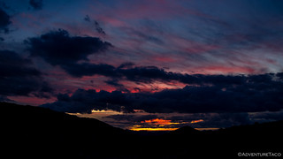
Even with earplugs, sleep was hard to come by with 20mph winds buffeting the tent and shaking the truck. That meant that as the light outside started to change, we were both already awake and it was no trouble at all to hop out of the tent to capture what turned out to be a colorful - if distant - sunrise!

With this being our last morning to explore - a 20-hour drive home mandating that we leave the area by mid-day, we promptly retreated back under our comforters for a few minutes to soak up a little more warmth before dressing and taking care of breakfast. By 7:30am - our earliest morning by far - we were fed, watered, camera'd, sunscreened, and ready to go!

Muddy Mountain road closure sign. Quite the list of organizations worked to close this road.

@mrs.turbodb climbs a 1 mile long, 25° trail that serves as a gatekeeper to Hidden Valley.
The first mile of our seven mile loop was one of the more difficult. Aptly named, Hidden Valley is accessed only with a bit of work, climbing up and over a ridge that hides it from unknowing passers-by. As we climbed, the perspective changed dramatically - the truck quickly shrinking in the distance below us, early spring flowers (Indian Paintbrush) dotting the trail at our feet.

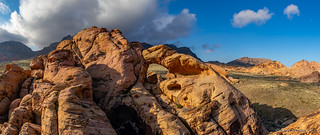
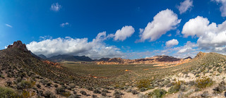
Warm and a little short of breath, we reached the ridge and were greeted by the splendor of what we were about to explore - the colorful outcroppings of Hidden Valley, revealing themselves before us, beckoning us onward.


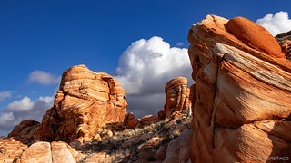
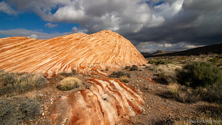
Following the faint remnants of an old road, soon found ourselves wandering through these majestic mounds of sand, their alternating light and dark layers so intriguing in their pattern and construction.


We had two real destinations in Hidden Valley, both near the apex of our loop. The first was an arch high above the valley floor and we arrived just as the sun and clouds were showing off on a bit of sandstone nearby.

From there, it was a short jaunt to the arch and I must admit that I was initially a little bummed to see that we'd be photographing it from the "wrong" direction - the accessible side of the arch in the morning shade. In retrospect, the lighting adds a cool touch which I actually appreciate, and is a great reminder to always be thankful in these situations, as they tend to work themselves out.


But - as I mentioned - in the moment what I was really thinking about was, how can I get a good photo from the other side?, and since we had to head that direction anyway on our loop, we didn't spend much time admiring the arch before getting underway again - the light still playing with the mountain-sized bread loaves in the distance.

Well, it turns out that views of the arch from the sunny-in-the-morning-side are reasonably difficult to get - requiring a good amount of class 3 climbing and careful route selection. All I could think was... challenge accepted!
I eventually found myself above the arch, on the sunny side.

And then with some down-climbing, a shot through the arch.
Ultimately, I think I actually like the "shady" photos better, but the journey to the sunny side was more than enough fun to have done even if there'd bee no photo to chase, and I'll be doing it again if I visit in the future, maybe spending even more time hopping around the glorious pile of rocks!
The climb also revealed a couple of spectacular wind-hewn sandstone walls along the way.


From the arch, we continued our cross-country journey along a route I'd scoped out on Google Earth. I had no idea if it was passable in real life, but online it appeared to route us through some of the more amazing formations in the valley. And so, when we discovered that for once, real life matched our research, we were giddy. Especially my associate.


Soon, we crested the final rise between us and our next destination - a tinaja that I hoped could be the highlight of our entire trip! As it rose up in the near distance, I started to get excited - you know, that feeling you get a day or two before you leave on what will be an epic adventure. 

As we approached, even @mrs.turbodb was getting excited. I don't know if I built it up too much or if it was just the anticipation that was getting to her as well, but as we approached the base, I quickly scurried up while she took in the candy cane colored stripes from below.
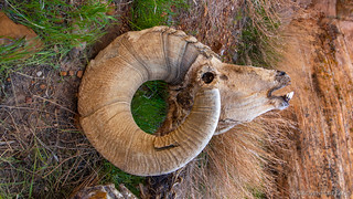
"Well that's weird," I thought as I reached the basin, and I called down to @mrs.turbodb, "There's a dead sheep in here!" Because there was. But the weird part was that the tinaja looked nothing like what I'd been expecting.

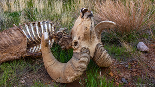
As we both looked down at the carcass, I realized what was going on. I looked at @mrs.turbodb, who was of course curious about the goofy grin that had spread across my face. "We're in the wrong spot," I said.
What I'd realized was that the monolith didn't end at the edge of the basin containing the sheep. In fact, the upper wall at the far end of the depression was the highest point of the monolith, and the tinaja was still hidden from our current vantage point. Hidden in plain sight, for anyone who doesn't give up or stop exploring too early!
As we skirted the depression and headed to the crest of the mound, the rock fell away and rose again - revealing the tinaja for which we'd been searching.

Twice hidden in plain sight.
We spent half an hour in this special place. As the sun danced across the tinaja and valley floor, the colors of the rock, water and sky changed before our eyes, mesmerizing even the 5th, 6th, and 7th times. Having made good time on our hike to this point - it was not yet 10:30am - we allowed ourselves some extra time to enjoy this amazing destination, happy to unknowingly have saved the best for last.
Eventually we found our way back down from the tinaja and around its eastern escarpment, expecting the colorful stripes to be most dramatic on the side bathed in morning sun. We were right.

And then, it was back - approximately - the way we'd come. Sure, there was a bit more trailblazing across the floor of the valley to get to the trail, but once we did, we were able to pick up the pace - with frequent stops to look back and take in this very cool place while we still could.

By 11:00 we were back on the ridge that keeps Hidden Valley hidden, the sun now high enough that much of the valley was bathed in its glow, distance still obscuring the true pleasure that awaits anyone who opts for the 7 mile hike through this wonderland.
And there, tiny in the distance below us - our ticket home, parked at the end of a lonely road in the middle of nowhere. Perfect.
Back in the truck, and with a small snack in our bellies, we headed north - back the way we'd come the previous evening. A bit sunnier this time, we stopped here and there on our way to the highway - doing our best to prolong the inevitable - going home.


Pavement came a few hundred feet from the Valley of Fire highway and we set about the familiar exercise of airing up. To full pressure this time - a 20 hour, 2 day, drive ahead of us before we'd reach home. We'd head into the outskirts of Las Vegas for a quick bite to eat and then north on US-93 until the sun disappeared to our west, and then even a bit further than that.


It had been an amazing trip. We'd accomplished nearly everything we'd planned, but not at all as we'd planned. And that is what makes it an adventure!
")


What an epic adventure! I’ve been pouring over Google maps and searching this area. I’m happy I found your blog. Thank you so much for the inspiration! How far down the byway do you think I could get a small-ish camp trailer? I have a 4Runner so getting to the trailhead isn’t an issue. Just trying to camp as close as possible. I’m especially interested in the hidden tinaja. Thanks again! Cheers, Mike
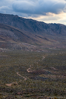
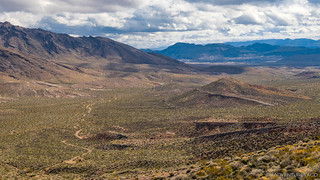
Glad you enjoyed it Mike! Definitely a cool area, there around the Byway. As far as a camper goes - it probably depends on the camper and driver. An expedition-style trailer could make it further, obviously, than a teardrop or other more recreational trailer. There were definitely some places where the road is rough - driving up through washes, etc. This photo shows a bit of what you'd be going through.
I will say that we saw several campers, and they all stopped reasonably early on the byway, not wanting to head through the rougher sections with their RVs/trailers. Some of that comes down to driver comfort as well.
You could always leave the trailer if you felt like it was getting rough, and just take the 4Runner through the rest of the route (however far you end up wanting to go). 👍
Thank you so much again for the info! Probably a good idea to drop off the camper and scout ahead haha. Cheers man and keep up the great work!
Such an awesome write-up and great photos to boot! My buddy and I were just in this general area yesterday then seeing your post here, today, giving more inspiration to explore the area deeper. We were both curious, what time of year did you two hit this area?
Thanks again for the detailed info and for sharing your adventure.
Hey Joseph, glad you enjoyed the story! This was part of our Mojave East (Mar 2020) trip, so that's the timeframe. If you haven't read the rest of the trip, check it out! Lots of cool stuff in the area. 👍
is the pic you captioned "twice hidden in plain sight" at these coordinates?:
█████████████████████████████████████
I found something that says to take bitter springs byway to these coordinates then head southwest to the ones above:
█████████████████████████████████████
sound correct?
Hey Kyle, glad you thought that tinaja was as cool as I did! I've been back another time, and it's definitely a neat spot (though, things have changed a bit since I was there the first time). Here's my approach on sharing/confirming specific coordinates. (Do you have a GPX for that?) Have fun exploring the Muddy Mountains, they are always a blast!