
There are several places that I've wanted to check out in Death Valley for quite some time, but that haven't fit into the route or schedule for previous trips. Hoping to knock off a bunch of those places that I've "left behind," I set about planning a route that would take us along West Side Road and the eastern escarpment of the Panamint Mountains. From there, we'd repeatedly climb into the canyons, exploring the mines, narrow passages, and vistas that each had to share. It would - I thought - be a lot like our trip along the Nadeau Trail, or our recent foray into the Inyos.
In fact, it was nothing of the sort.
As always, we had a fabulous time, but left behind more than half of the canyons we'd hoped to explore. Oh, and we left behind something even more surprising... the Tacoma itself. 
Getting There
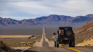
As has been the case for years now, the trip began with a 1,100-mile drive south. With atmospheric rivers wreaking havoc on the west coast, we had to make our first decision quickly: risk snowy conditions when crossing the Cascades in Oregon or California to save a few miles, or add a bit of time to the trip by heading east - towards Boise, Idaho - before turning south for the remainder of the journey.
Not wanting to find ourselves plodding over a mountain pass at 15mph in white-out conditions, we opted for the slightly longer route - one that we've travelled many times - and settled in for the 19-hour grind to Beatty, NV.

It was just after 5:30am as we pulled into our camping spot outside of Beatty and I set my alarm for three hours of shut eye. One thing was for certain - we were off to a "great" start!
The Keane Wonder Mine and a Quick Stop to Meet Jeremy
With the best of intentions, things got off to an overscheduled start when, at the last moment, I threw another "left behind" location - the Keane Wonder Mine - into the mix.
Having been closed from 2008 to late 2017 for structural stabilization, mine mitigation, and soil sampling, we'd just never gotten around to visiting after it reopened to the public. I figured that - as it was on our way to West Side Road - that it we might as well make a couple-hour* pit stop to explore such an important location.
* Surely, we could complete a five-mile hike with more than 1,500 feet of elevation gain, and take photos in two hours, right? Right.
As usual, we'd consulted our Death Valley bible as we'd driven to the parking area for the mine, and Digonnet suggested that rather than hike directly up the old mining road, we could make the excursion into a loop:
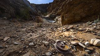
A more adventurous route to the mine is along the canyon that starts just south of the mill. The first couple of falls that soon block the way give a good idea of what lies ahead: a chaotic passage choked with rocks, high crooked walls, shallow pools in polished bedrock, and an impressive collection of falls. There are 11 falls higher than 10 feet on the way to the mine, and scores of shorter ones. The wash is so sinuous that it often gives little advance warning of what is coming next. The canyon traverses mostly Proterozoic schists, quartzite, and marble of the Crystal Spring Formation. The smooth outcrops of marble and quartzite are particularly pretty. Depending on their relative contents of quartz, biotite, and staurolite, the schists cover a wide spectrum of brilliance and color, from dull to sparkling, silvery to green, purple, and gold. The falls reflect this diversity and greatly vary in color, composition, and degree of polish. At places extensive metamorphism has folded the rocks into oddly distorted formations. You trudge across a broken landscape, hundreds of feet beneath the tramway, skirting fallen tramway buckets partly buried in the wash.
Some of the falls are crumbly and unsafe, while others are quite strong and fun to climb. At least two of them are impassable, and one probably exceeds 100 feet. There is always a way around them, often along short bypass trails built in the mining days. Use caution in bypassing the two high falls near the second cable crossing (about 0.6 mile in), which requires scrambling up loose slabs.Hiking Death Valley
That sounded fantastic to me - but a little more than @mrs.turbodb wanted to tackle after three hours of sleep - so we grabbed our handheld GMRS radios so we could keep in contact throughout our respective climbs, and set out.

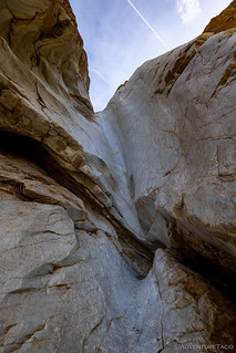
As I wound my way higher, one of the things that struck me was how wet the canyon wash was. It'd rained for a couple days prior to our arrival, and much of the ground was saturated and soft under foot. It was a very different experience than usual, and one that I found both intriguing and slightly disconcerting, given the usually-bone-dry nature of this wonderland.


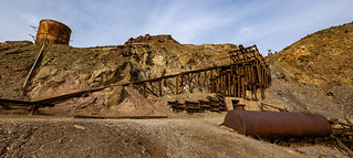
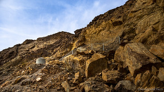
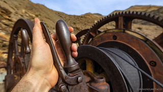
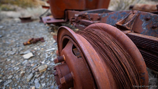
One of the best parts of hiking up the canyon was that the aerial tramway - that once carried ore down from the mines at 3,050 feet to the mill at 1,320 feet - continually crossed high above me, the tram towers still supporting cables and ore carts as they clung to the steep hillsides.


As if the tramway wasn't enough, the geology of the canyon provided constant interest. Whether climbing usually-dry falls, navigating 6-inch wide bypasses clinging to near vertical cliffs, or just admiring the changing colors of the rock, it was a pleasure I would happily repeat as I pushed higher into the Funeral Mountains.


Eventually - though the mining road had generally been a hundred feet or so above the canyon trail - I followed a drainage up to the main mining area. Now above @mrs.turbodb - who had stopped a couple hundred feet below at the upper aerial tram tower - I looked down to see her chatting with another hiker who'd made the climb on this perfect morning.
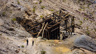
While most mines in Death Valley - or really, any location - were failures, the Keane Wonder Mine was anything but. Coined the "King of the Desert" by the Rhyolite Herald, it was discovered by Jack Keane and Domingo Etcharren in 1904. Capitalizing on their discovery, they sold the mine to Homer Wilson in 1905, who laid out plans for the nearly one-mile-long aerial tramway and an 80-ton milling complex. The first echoes of the mill's 20 stamps bounced off the Funeral Mountains in October 1907, and $20,000 of gold bullion (~$650K in 2023) was delivered to Rhyolite two weeks later. By December the mill was running around the clock, processing 70 to 75 tons a day at an average value of $18-20/ton. Except for a few short interruptions, the mine's tramway and mill performed almost flawlessly for five years.
A cyanide plant was installed in the fall of 1908 to further treat the 20,000 tons of mill tailings that had been saved since the early days of the mine, nearly doubling the production of the ore.
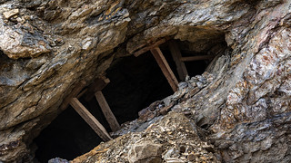
Ore bodies started playing out in 1912. In August the wooden pillars supporting the tunnels were removed to mine the last of the ore, cleaning out another $10,000 but sacrificing the mine in the process. By the end of 1912 the mine had shut down. After five years of glory and nearly one million dollars (~$31.7M in 2023), the Keane Wonder Mine had become one of Death Valley's largest - second only to Skidoo - gold producers.

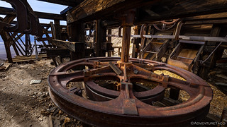
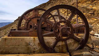
The upper tramway was an amazing piece of equipment, reminding us of the terminal of a high-speed quad ski lift. With enormous pullies and tracks to guide the ore carts, two chutes from the attached ore bin would load the carts as they passed by, the additional weight of the ore allowing each full cart to pull one that'd just been emptied at the mill 1,500 feet below.


Exploration of the upper mine area complete, we were a little over two-and-a-half hours into my two-hour estimate for completing this detour. It wouldn't have been a big deal at all, had I not already arranged to meet Jeremy - an NPS employee who leads the Abandoned Mines Program at the park - to hand off some old 20mm canon shells that we'd picked up more than a year ago when we'd hiked Military Canyon in the Owlshead Mountains.
Note: For anyone hiking in Death Valley (or any National Park for that matter), it is illegal to remove artifacts from the park, and anything over 50 years old is considered "historical." I'd always known this about remains of mines, cabins, and rocks, but I hadn't realized it was true when we were picking up these casings. In fact, we thought we were doing the park a service, in the same way we gather up Mylar balloons. It was Jeremy who - kindly - reached out to me when I posted a photo of the "trash" we'd collected, correcting my understanding. Having not yet recycled the casings, I offered to return them, which he took me up on, and we've been trying to get together ever since - to do the hand-off, and just to meet each other in person!

At any rate, heading down the mountain was a quicker - and somehow steeper - operation than the canyon climb up, and with only a few stops to investigate some of the tram towers along the way, we made good time.


Back in the truck, it was just before 2:00pm when we pulled into the Furnace Creek Visitors Center to make lunch and met up with Jeremy. And, while lunch was good, the real treat was getting to talk to Jeremy. Like us - probably more so, given his position - he loved Death Valley, having started on a road crew and then working his way into a 17-year career with the park service. Constantly exploring and figuring out ways to best preserve the mining history within the park boundaries, he was literally the guy who makes much of what we do so enjoyable.
Super. Cool.
Finally, to Trail Canyon
Having planned to head down West Side Road and up to Trail Canyon just after 10:00am for a 5-mile hike up one of its three main forks, I realized as we pulled out of the visitor center - at 3:00pm - that we only had about 90 minutes of daylight remaining.
Guess I'd underestimated how long that "left behind" Keane Wonder Mine hike would take. Still, 10/10 would do the same way again! 
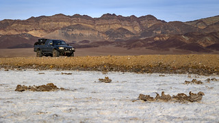
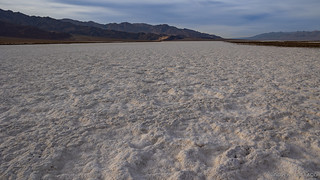
With no real hope of squeezing in the hike before dark, the pressure was off as we rolled south on Badwater Road and then crossed the salt pan to the base of the Panamint Mountains. @mrs.turbodb took the opportunity for a quick nap, and I enjoyed a part of the park that I rarely visit due to the relative crowdedness compared to my usual haunts.

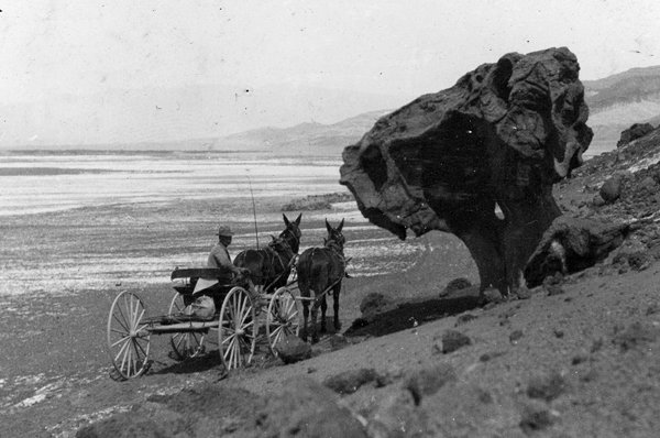
Update 2026-02: The rock is called Mushroom Rock / Devil's Throne. Tourists have posed with it since forever and slowly chipping off souvenir pieces. The old road ran right next to it, and today's modern pavement is further downhill side.


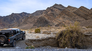
Eventually we began making our way up Trail Canyon, our thoughts now on finding a spot to camp before the sun dropped below the horizon and the temperatures dipped into the low 40s °F.
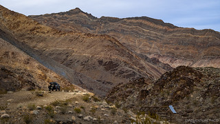
Like many of the Panamint's canyons, Trail Canyon's banks start as rounded hills, quickly growing to high ridges, then to walls of solid rock. Distinctive bands across its slopes display a sizeable portion of the region's geologic history. From its mouth to the confluence of its three main forks, nine stratigraphic formations - from the Late Proterozoic to the Late Ordovician - are displayed in sequence, covering a span of some 250 million years.
The first one, on both sides shortly after the road drops into the wash, is the Ely Springs Dolomite. Just up canyon, erosion has divided the next few formations into giant ribs. The interbedded limestone and dolomite belong to the Bonanza King Formation. The last one, the Stirling Quartzite, ends at the confluence.
Hiking Death Valley

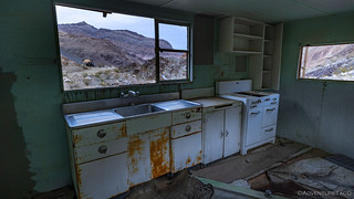
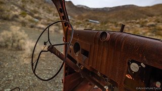
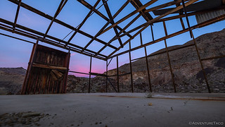
With light fading quickly, we spent the next 15 minutes or so exploring this little camp that was in use from the 1930s through the 1960s (or so). Several structures and plentiful equipment remain, though none of it in very good condition.


After poking around camp for a bit, the sky started to change colors. Knowing the forcast in the coming days was for cloudy skies, this resulted in my pace quickening as I frantically ran from location to location to try and capture the pinks and purples as they spilled across the horizon.
@mrs.turbodb knew better, and just watched with a smile.


With the light show complete by 5:00pm, it still seemed a bit early for dinner. But, knowing that it would be easier to cook and clean with a bit of non-headlamp illumination, we set about preparing our usual feast: taco-rritoes, of course.
And then, tired from measly three-hours of sleep we'd gotten in the last forty-eight, we brushed our teeth and climbed into bed. I had no idea at the time, but this wasn't the only day that I'd underestimated how long our adventures would take. Nope, not by a long shot.


As I've said before, I really enjoy your adventures showing us great photos and giving descriptions of places that I'll never be able to visit myself, thank you again! In my hiking days I was constantly amazed at how miners got heavy equipment into areas where there were no roads and then extracting minerals from the area.
Man, these guys work eithic (or was it gold fever? ?) had to be amazing. Of course, they built roads to these places to do a lot of the heavy lifting... but just building those roads - insane!
Thanks as always for the comments - I'm glad you're enjoying and it's always nice to have you along!
I've got to get back to the Valley. Up Warm Springs Canyon is one of the last Arrastra's in the west, next to the Talc Mines. Further up in Butte Valley is heaven with Mengal's, Russell's, The Geo, and Emmitt's Cabin's. Ran into Emmitt Harder at the Crow Bar. He owned the South Panamint's. I'm sure you've read his book 'These Cabins Are Filled With Ghosts' I was wondering if I could get to that Keane Mine from Greenview Rd. That's one place I've missed over the years. That pully system rig at the top is too much. That giant cable pull must weigh two tons or more. If I buy that clutch disc, does the pressure plate come with it?
I've found that there are quite a few arrastra's around, though few of them are in the same condition as the one at Warm Springs (here's a photo of that one that you remember so well).
As for Greenview Road - I'm not actually sure of the road you're talking about, so the answer is, "Dunno?" You can access the mine from both the foot as well as the top of the Funeral's though, as long as you're willing to put in the elevation!
Greenview is aka as Furnace creek rd. It snakes from Dante's view to Tecopa. Probably about 40-50 miles. Easy trail that skirts the top side of the eastern mountain range that encloses Death Valley (Furnace Range?). Anyhow I found the Keane Wonder on that little cut-off on Beatty Junction Rd. I'm going to check it out, now's the time for DV exploration.
Ahh, I didn't realize they were the same road.
Just a quick heads up, I happened to notice yesterday that Keane is closed from Jan 26th - Feb 9th to fix some of the fencing up around the collapsed shafts (which I mentioned to Jeremy (NPS) as having been toppled by rockslides). Anyway, you're right on that now is the time to visit... as long as "now" is in about a week, hahaha!
This is an absolutely excellent guide and your pics are fire. Keep it up!
Thanks Melanie, glad you enjoyed the story and photos, always nice to hear when folks do! 👍 Heading up to the Keane through the canyon wash is more work, but I think it's totally worth it!