
I'd pulled into my camp site just south of the Utah - Arizona border a little after 10:00pm. At an elevation of 2,700 feet, even with a little breeze, it was balmy compared to what I'd experienced the last couple nights in Nevada. Orienting the truck so the morning sun would act as a natural alarm - spilling into the tent as I slept - I soon drifted off to sleep, excited for the easter-egg-like hunt that I envisioned when I awoke.
Little Black Mountain

My wake-up plans were foiled when I awoke naturally before sunrise.
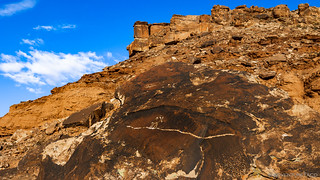
Knowing that I'd have trouble finding petroglyphs in the dark, I read my Kindle for a while before rousing myself out of bed and loading myself with all manner of electronic and viewing devices, meant to help discover and track the plethora of rock art I was sure to find as I explored the sandstone chunks that lay at the base of the 500 foot tall mesa known as Little Black Mountain.

I'd chosen a nice place - mostly by accident - in the dark.
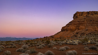
The half-hour before sunrise is always such a special time.


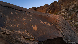
One of the first glyphs I found, as the sun spilled over the horizon.
I've heard that there are 44 boulders with petroglyphs, and initially I had my heart set on finding them all. Or, at least, most of them. Reality set in after an hour, as my count was reaching the number of digits on which I can count - I'd already seen so many, there was just no way I was going to get to them all. Still, through it all, I loved the variety - both in style and age - and even as I wound down my time walking around random boulders in the desert, I'd get excited when a new glyph would present itself.
Uh-oh, that snake got him!
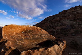
This rock was interesting - it's not often that the tops are the canvas.
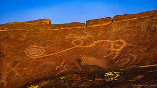
Whimsical spiral.

Dang, the deer and wolf got this guy too!


Two more interesting panels.

Invisible sheep.

Sentry of the morning light.
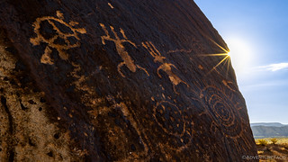
Sun (and sunstar).

Climbing the mountain.
Stay the trail.

Fat sheep. Sorry, horizontally endowed.
Eventually - after walking around the site at least twice - I headed back to the truck to eat a quick breakfast and put away the tent. Everything had been completely dry when I'd climbed down the ladder, so I was a little surprised to find a few damp spots on the shady parts tent, now a couple hours later. It was - I realized - a function of temperature, more than anything else. Like a glass of ice water, the parts of the tent that were colder than the ambient air caused condensation to collect. An easy fix - simply reorienting the Tacoma so that the shady bits of tent were in the sun - while I ate breakfast, and soon I was bidding farewell to what had been a very pleasant camp site.

Whoops, someone needs a diet. Or maybe just some pants that aren't old enough to vote.

By the time I was leaving, the clouds were adding a nice bit of interest to the sky.
Back into Utah - and Canaan Gap
Usually, I try to take relatively efficient routes when I'm out exploring - so I don't find myself backtracking, wasting fuel, and most importantly, wasting time. However, on this trip I'd had to optimize for the amount of remaining daylight, and so for the next couple of hours, I retraced some of the path I'd travelled the previous evening. Through St. George, I skirted the north side of Warner Valley before passing through Hurricane. My ultimate goal for the day lay just over the border in the Arizona Strip - near the town of Colorado City - but before reaching the border, I turned off onto a dirt road that I hoped would take me to some unique petroglyphs - if I could find them!

Gooseberry Mesa (I think?) was looking fantastic.
Almost immediately the dirt road I was traveling turned to muck. It wasn't deep enough that I was worried about getting stuck - that would come later - but it was soggy enough that chunks of mud were being flung in every direction, and I tried to moderate my speed in order to keep the truck as clean as I could.

The red clay roads were sticky as I made my way through a mixture of snow, mud, and rocks.

On the prowl, hunting for petroglyphs.
After a few miles of relatively slow going, I found myself at the top of a mesa, right on top of the waypoint I'd marked on my GPS. Others had parked here as well, and I recognized some of the surrounding landscape, so I knew I was on the right track.
The hunt was on.

A view I knew.
I searched and searched, checking all sides of the nearby boulders, working my way farther and farther from the location of the petroglyphs that I'd marked on my map. There was no certainty in this point - I'd gleaned it from scouring the interwebs; the person who'd posted it in 2011 adding the caveat to the group he shared it with, "This is the spot I've marked, but I've never been there. If anyone goes, let us know if you find them."
A little worried that the same slow trainwreck that'd pushed me out of the Pahranagat Valley was happening again, I decided to check out one final area that looked promising to me. This meant working my way off the mesa, but after 20 minutes, I found myself rounding a promising point of rocks. There - in front of me - that which I'd been seeking.

Panel in a band of varnish.
The thing that makes the Canaan Gap petroglyphs unique is the depth to which they've been sunk into the sandstone. Whether this was the original depth to which they were carved, or whether erosion of the varnished surface and exposed sandstone has happened at different rates, the effect is striking. I took my time meandering between the panels, examining the figures and marveling in their relief.

The carvings are so deep that shadows are cast by the edges of the desert varnish.

This sheep panel reminded me of The Great Hunt in Nine Mile Canyon.
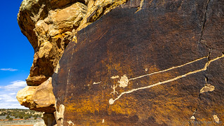
Long lines on a mostly blank canvas.

Such variety: a two headed sheep, a bear, Cave Valley anthropomorphs, and more!
Pretty jazzed to have found this site after thinking that I might have struck out, I made my way back to the Tacoma and navigated my way back to UT-59.

Even after only a few miles, I'd need to spend some serious coin at a local self-service car wash before I could deliver the truck back to storage.
More Mud to Paiute Cave
Passing through Colorado City, I once again found myself in the Arizona Strip, this time headed towards the North Rim of the Grand Canyon. I wouldn't be going that far today - though I have in the past - but I still had a good number of miles between me and my final destination.
Normally a reasonably graded road, the problem today was the snow that had fallen - and was now melting - over the course of the last week. If I'd thought Canaan Gap had been a mess, this road was in a whole different class!

Apologies, future explorers. 
If I'd been the first to drive this slippery slop, I'd probably have turned around, hesitant to leave the road rutted - a real pain in the rear when everything dries out with summer. However, given that many vehicles had made the trek ahead of me, I did my best to stay the course as fist-sized hunks of mud were flung twenty feet in the air, only to land squarely on the roof. Or tent. Or even in the bed of the truck.
That car wash was going to hate me. 

After much spinning of tires and slow going, I found myself entering a land of cinder cones dusted with powdered sugar.
It wasn't just the mud that was like Canaan Gap. The location of Paiute Cave was also one where I wasn't quite sure that I was actually going to the correct location. My anxiety increased as I followed a series of spur roads - each one snowier than the last - deeper and deeper into the backcountry. At one point I even considered getting out an walking the final few miles - since I was pretty sure it was harder to get stuck hiking as opposed to driving.
Then - in the corner of my windshield - I noticed a register! You know the ones - a metal post with a box on the top - used by agencies the world over to track who, and how many, people visit sensitive sites.
I must be in the right spot!

Sweet, sweet, relief.
Parking the Tacoma in a dry a spot as I could find, I was in such a rush to check out the treasure I knew existed in Paiute Cave that I completely forgot to bring my tripod, flashlight, and the correct lens. This of course meant two more gingerly-made trips across the spongy slop that currently passed for high desert grasslands, by which point my shoes looked as disgusting as my tires.
Still, as I headed into the cinder cave, I didn't care. Not one bit. I could see what I'd been searching for, and they were spectacular.
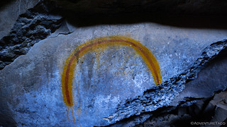
Vibrant rainbow.
Set deep far back from the entrance - and completely shielded from the sunlight that so often fades pictographs in more common locations - the red and yellow pictographs were some of the most vivid I've seen. I was like a kid in a candy store, checking out one after the other, and then back again.

Diversity of design.

The largest panel.

Man on the grass.


Man with three feet. | Man with white hair.

Man over the rainbow.

I thought this spiral was interesting as it was one of the few shapes in the cave, and as the area above it was in constant shadow, algae grew right up to the shadow line.
Eventually, it was time to go. Climbing out of the cave and heading back to the truck, it was nearly 3:00pm when I started back through the red clay that - even after I spent 34 minutes at the local Red Dirt Car Wash - will cling to the truck for years to come.

Secret passage.

Trusty steed under the shadow of a cinder code.

Headed home.
By the time I reached Colorado City, clouds had moved in, and long rays of light streamed in beneath them, illuminating the Canaan Mountain Wilderness. For the next few hours, I'd clean up the truck, rearrange my belongings, and make the trek to Las Vegas - where I could restock my stomach - before hopping on a flight back home.

With rain in the forecast, I was glad to be back on pavement.
On the one hand, the trip had been an absolute failure - not only had I botched the search for the petroglyphs I was after, but I gave up even looking. On the other, I wouldn't have had it any other way.
Well, except for the small detail of forgetting to clean out the fridge when I left. That's not going to be a fun situation when I return!


Very nice and I've heard of/seen vehicles stuck in the Utah mud, it's legendary! Some wonderful "glyphs" also. To paraphrase Star Wars, "There are NOT the glyphs you're looking for." Thanks for another fine adventure.
Thanks John! I've never gotten stuck, but I've certainly gotten close. Oh, man, the mud we saw on Day 9 of the F. U. Rain trip was crazy.
Still, even with what I experienced this time... I'll be pressure washing it out of the nooks and crannies for years, I bet! ?
Just by chance is there any way you can share your trip itinerary? I dream of taking a trip like this someday! I have visited the Three Rivers Rivers Petroglyph site in New Mexico. I thought that was amazing!! Hopefully someday I get a chance to see more.
Brad
Hey Brad,
I don't have a GPX file to share - you can read my take on that here: Do you have a GPX for that? - but if you read through the story and follow along with a map, I think you'll be able to figure out the route. Also, here's how I go about building up my routes, which will hopefully help you as you build up yours: 4 part Route Planning Series.
I'm happy to help with specific questions or recommendations once you have your route, and if you have specific options you're considering as far as that goes! Have fun out there, it's a cool place to explore!
Keep on Exploring!
A great trip even with the mud, and an amazing amount of petroglyphs and pictographs. I enjoyed the trip, thanks for sharing Dan, we all appreciate it very much.
Hopefully next month I will be heading back down to Grasmere, I am very excited to get out of town.
Kenny
Oooo, that feels like an early trip out to that area - I bet you'll run into some mud as well! You'll be better suited for it with your mode of travel though, so that's good.
I can imagine that you're feeling pretty cooped up. Have a great time out there!
I usually get out there by mid-April and other times it has been June all depends on the weather. It dries up fairly early in the spring compared to other parts of the Owyhees. Eyeing Mann Creek Reservoir area maybe in May or June to do some more exploring. Found some old mines but not much of anything else, just beautiful riding and watching the wildlife, bear country.