
I can't say I was overjoyed when I heard @mrs.turbodb's alarm blaring away as she tried to find her phone in the mess of sheets to turn it off. It was 4:00am again, and just like the night before - a surprise, I know - the moon was still up. The winds had stopped only about 15 minutes before her alarm, and I think we were both in the middle of the best sleep we'd gotten all night.
Except that now we were awake, and decided we might as well get out of the tent to take a look around.

Can you believe that's the moon over there, not the sun!
You see, apparently there was a meteor shower while we were on this trip, and with it being a relatively dark area of the sky - when there is no moon - @mrs.turbodb wanted to see what she could see. I, on the other hand was more interested in figuring out whether I could photograph the Milky Way, since that's something I've never done before.
A bit of playing with settings on the camera, and eventually I had - at least on the small camera LCD - something that looked like it might be workable. I must say, for a first time trying - and though there's clearly room to improve - I'm really quite pleased.

Our galaxy, stretched out above Black Rock Desert.
Well, we ended up hanging around in the calm night air for thirty minutes or so until the moon finally did set, and boy, it sure got a lot darker. Unfortunately, we didn't catch any meteors, so we climbed back into the tent for our last couple hours of sleep. Or really, laying there, since I don't think either of us actually fell back asleep before sunrise at 6:30am.

I always love a desert sunrise, even if there aren't any clouds to pick up the color.
With another full day ahead of us, we were up and about relatively quickly, and just before breakfast and camp break-down, the sun spilled across the playa.

I got a nice - accidental - highlight effect by parking on a lighter area of the playa. Oh, and where were those clouds a few minutes earlier!?
I think we finished the remainder of the strawberries with our cereal this morning, as we alternated between spoonful's of Cheerios and glassing the perimeter of the playa with binoculars. We were - it seems - the only ones brave (or dumb) enough to weather the previous night's wind, no other vehicles visible from our location in the dead center of the lakebed.
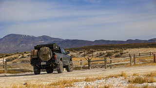
Camp teardown quickly followed, and soon we were headed north.

Black Rock Mountains, mere ghosts in the distance.
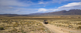
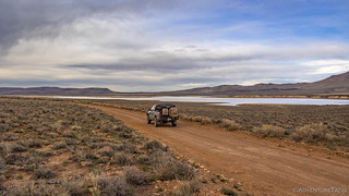
For anyone unfamiliar, the Black Rock Playa is sort of "Y"-shaped, and we'd camped about a third of the way up the center trunk. Our first destination - Black Rock Hot Springs - was at the intersection of the trunk with the two branches; at the base of the Black Rock Mountains. To my surprise, this wasn't just a couple minutes away at 50mph - rather, it took us nearly 15 minutes of highway speeds to reach the small dunes at the edge of the playa! Dang, this place is gloriously enormous. I can't wait to come back and spend an entire day driving around the entire surface, looking for interesting things along the edge and through the middle!

These might be more "salt dunes" than "sand."
Just off the playa in a sea of sand, salt, and tall grass, we came on the hot springs. As always seems to be the case, there was an single old dude floating around in the water, enjoying himself way too much. Keen to give him a bit of privacy, we passed on jumping in ourselves.

Visitor log or desert mailbox? The BLM and visitors apparently have different opinions.

I've edited out the old dude. You're welcome.

The water temps here were perfect, and the bottom looked nice and sandy.
Having passed up on a soak, we poked around the area a bit, and at some point I realized that what I initially took to be a pile of old wood was actually the remains of an historic wagon! We were, after all, on the Applegate Trail.

If you're going to break down, I guess this is a reasonable place to do it.
@mrs.turbodb kindly held down the fiberglass BLM marker - the one asking visitors to preserve our cultural heritage - as I took a photo. Unbeknownst to us, that was a terrible idea, as she was digging dozens of little glass shards out of her fingers for the rest of the day! But for now, we were back on the trail, working our way due north towards our second hot spring of the morning - Double Hot Springs.

A sandy road is a dandy road, I say; the sand makes it soft and pillowy!

Buddha Barbie?

Probably not.
We didn't wonder long about the Barbie post, I just suggested to @mrs.turbodb that it was probably a Barbie Loop road marker in a place like this  and shortly we arrived at the hot springs.
Hot springs - in the Black Rock Desert - are apparently like the story of Goldilocks. Trego Hot Springs had been too cold, Black Rock was just right, and Double Hot Springs was quite clearly warmer than we wanted to even test with our fingers.
No single old men in this spring, we had it all to ourselves.
For obvious reasons.
More than one person - and several pets - have died in this spring, a fact that I was reminded of as I hopped around the edges trying to get a shot. Not to worry, I wasn't going to let my new camera get wet so soon after acquiring it.

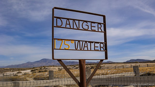
One of the two sources. Both were deep and would have been fantastic to bathe in...if they were only 70°F cooler.

Don't bust the (salty) desert crust.
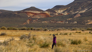
Continuing on the Applegate Trail, the mountains to our north were suddenly bright with color. There, under layers of sage, were brilliant stripes of white and orange as we turned off the main route for our next short detour: the old remains of Hardin City.

Splashes of orange.
It's hard to believe, but Hardin City was a mining camp established in 1866 when prospectors thought they had found the site of James Hardin’s lost deposit of silver (1849). As usual, the lure of shiny metal made excitement run high, and investors, prospectors, and others swarmed to the area and erected two stamp mills. Predictably - given that the site is built on the silt of the playa - no silver materialized, and the town disappeared less than six months after it was established.

All that remains of a stamp mill, returning to the dust from which it was built.
There must be more here?!?
More interesting than Hardin City - for me at least - was a nearby site known as Clapper Creek. It was here that Peter Lassen - for which so much in California is named - and his prospecting friend Edward Clapper were killed on April 26, 1860 as they too searched for Hardin's lost silver. A plaque now stands alone in the spot, the murderer never caught.

So green on our way to Clapper Creek.

Though he didn't find the silver before being killed, I'd say Lassen was more "on track" in this landscape than the fools digging in the dusty playa.

I really enjoyed these clouds as we looked back over the Black Rock Desert.
Our jaunt over to the Lassen murder site was the last stop before we reached the end of the playa - which, really, was already covered in sagebrush at this point anyway - finding ourselves looping through Soldier Meadows on the way to what I hoped would be the highlight of our trip. It was - at the very least - what I'd planned the trip around: experiencing the narrowness of High Rock Canyon.
Before we could do that, we still had a few miles to go - winding our past Soldier Meadows Hot Springs (which we'd later visit), and through Fly Canyon.
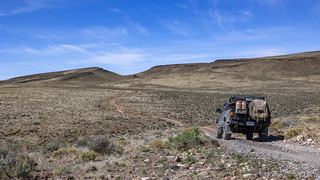
Lest we forget we were in the high desert, the high desert landscape reminded us where we were.

APPLEGATE TRAIL - FLY CANYON
"We had some very stony rodes. One hill we locked both wheels & put on ropes to let our wagons down. All got down safe. Saw some hansum sights along the rocks holes maid by the wind." -Abram Minges, 1849

We got to drive through Fly Canyon, a treat since I thought we were going to have to hike it!
As we drove through the canyon - never quite at the bottom, but along the side of the wash - it was both fun and terrifying to think what it would have been like to come this way as a settler. The bottom of the wash - where they most likely travelled - was not conducive to anything but rock hopping, and portions of the canyon were so narrow as to nearly be considered a slot. Our speed slow, it was with a keen eye that we spotted a marking on the far wall - the name of a weary traveler, painted on using axle grease.

S p _ _ _ _ _
We spent a few minutes trying to figure it out - to no avail - before being distracted by some nearby bird nests made of mud. It wouldn't be the last time we had trouble reading nearly 200 year old axle grease.
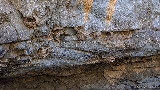
You gotta eat a lot of mud to spit up an entire nest onto a rock wall. Just sayin.
From Fly Canyon, it wasn't far to High Rock Canyon. We were now a mere 15 miles from where we'd started our loop just 36 hours or so before - and once again, there was a locked gate across our path. It was expected of course, and the plan from here was to hike four miles up the canyon - along the road - to see the narrows. But first, lunch.

South end of High Rock Canyon. I have to say, the geology was mesmerizing even before we began our trek.

Ready for an 8-mile hike.

And we're off!
The road through Black Rock Canyon is reasonably flat. However, being travelled primarily by cattle while the road is closed to vehicles, two things became immediately apparent: first, there was a lot of crap on the road; second, the road surface was soft and dusty - a little bit like walking in sand. We did our best to stay on the firmer areas in order to keep up our pace.
The first mile or so of the hike was through a broad valley - the canyon walls climbing gracefully along the edge. We could see where the modern day road and the historical wagon track merged and split several times, BLM likely doing their best to preserve the old route. And then, eventually, the canyon started to narrow.

Three pillars standing guard; marking the beginnings of the narrows.
Winding our way through the narrower section, our heads were on swivels. It wasn't narrow like a slot canyon, but the walls climbed high quickly and the orange rock was as striking as ever. Two-and-a-half miles in, we came to a cave - only a small opening presented to the outside world. The inside was a different story - not comfortable, there were rocks all over the floor - but spacious. Black soot on the ceiling indicative of those who came before us - perhaps during the winter - who were likely elated to find such lavish shelter.

A search for petroglyphs and other rock art was fruitless.
A bit further up the canyon - less than a quarter mile away - we found what we'd expected to see at the cave: evidence of those who'd come before us. Those who hadn't arrived via Tacoma, but who'd travelled on foot from many hundreds of miles away.

Towering walls of stone.

George from Wisconsin, in 1852.
And of course, we couldn't help but stir up the current residents - this little guy, even larger than the one I'd seen in Tunnel Camp, and running around like he owned the place.

This is my rock, and don't you forget it.
Our eyes now on the lookout for more names chiseled into the wall, it as a combination of my and @mrs.turbodb's near-blindness that spotted the next batch. Actually, I was admiring a huge slab of stone along the side of the canyon, and how it seemed to be made of gently curving layers, when @mrs.turbodb pointed out that there were more names! This time - as they'd been in Fly Canyon - they were painted on the wall with axle grease, the pigment of the white man.

The rock wall I was admiring. I admire strange things.

C. WHITE, AUG 18, 18__, IOWA

ABR____ (illegible)
With clear evidence "modern technology" isn't always better than just chipping away a bit of rock to leave your message about bighorn sheep, we continued on - now not very far from our turnaround point for the hike. You see, the plan from the get-go had been to hike four of the fifteen miles, to reach an even narrower section of the canyon that I'd marked as "fabulous narrow gorge," when I'd seen a photo of it in a trip report on advrider.com.
That had been nearly a year earlier, and I hoped that it lived up to my label - otherwise, I was likely to get it from my hiking partner.

That is quite fabulous, I think.
It'd taken us a little over an hour and a half to make it the 4.2 miles to this spot, so without too much lazing around, we started back the way we'd come. We figured it'd be just a little over an hour for the return trip, since there'd be fewer photos along the way. Theoretically.

Spring is coming.
Of course, fewer isn't none, so we did stop a few times when the sun illuminated the rock walls in front of us, the oranges and reds contrasting nicely with the sage, blues, and clouds.

Re-entering the narrows.

Emerging from the narrows, pillars of rock still guarding the entrance.
With that, we'd completed our loop, and we'd done it nearly a day ahead of schedule. We had a few more stops that we wanted to make as we retraced our steps out through Fly Canyon to Soldier Meadows, but it was time to start figuring out what we were going to do once that was done - because we couldn't just park and be done. Or could we?
I don't know the answer to that, but we postponed the decision for the time being, because at the mouth of High Rock Canyon, on the edge of what used to be High Rock Lake, a few dilapidated cabins sat in a field of tall grass and sage. Obviously an old ranch, headed over to take a look.

Looked better from a distance.
The cabins were in rough shape - nothing really noteworthy inside or out - and I think I was the only one who even got out to look around. I guess there was one noteworthy item - one of the cabins had a cellar dug under half of it, and was starting to crumble into said cellar.
And so, without further ado, we headed out to Soldier Meadows - a vast wonderland of nothingness - at the head of the Black Rock Desert.
Travelled by many, and yet so desolate today.
As you may recall, as we made our way through Soldier Meadows a few hours earlier, we'd passed the Soldier Meadows Hot Springs, and now was the perfect time to take a peak at them. I'd considered spending the night at a few designated camp sites nearby, but it was a Friday afternoon and there were already a few vehicles parked at some of the sites. A reminder that even in the middle of nowhere, people find a way to haul in a fifth wheel.

There were 5 pools, none of them very warm. @mrs.turbodb *almost* went in.

A nice camp spot, from this angle. Taken the other direction ... well, the background would have been trailers and UTVs. 
From Soldier Meadows, I'd planned to take one of three routes north to pavement at NV-140. This would take us through the mountains - past Summit Lake on a road bearing the same name - and then either fork left, into the Virgin Valley, or right, up through the Sheldon National Wildlife Refuge.
Summit Lake, home to its very own species of trout, found nowhere else in the world. No fishing though, this is tribal land.
And it was at this point that we had to make our decision. On any normal trip, we'd have chosen the route to the left. The road through the Virgin Valley seemed intriguing - several interesting stops along the way. However, the forecast was for rain, and after the muddy mess I'd encountered just a few weeks earlier in the Owyhee Outback, I figured that getting into mud on the first day of a trip was one thing... but that it was something else entirely on the last day of a trip, with commitments awaiting us at home.
And so, we left ourselves a little bit to explore in the future, and turned to the right - on a nicely graded road through the Sheldon National Wildlife Refuge.

Not named after the character on TV.

Our final descent into civilization.
It was easy, pretty, and got us where we needed to go - but I think both of us wished we'd chosen the other route, even if just a little. Which is fine - I reminded myself - because the whole point of this trip was to scout out the area. To figure out what looked like it was worth coming back to explore in more detail.
The answer - as often seems to be the case - was obvious: all of it!


One of my favorite areas in Nevada. You have to come back and drive High Rock Canyon. I did it in a full size boy was that fun.
It's definitely an awesome place. Getting through High Rock is definitely something I want to do - and there's a lot more to explore in the area, so it'll be a great way to head south and access all that. As one of your favorite areas in NV, do you have suggestions on things to check out? (Even just hints are fine, no need to share GPS coordinates, etc.)
I really enjoy these photos and the write up. have read them all. look forward to many more.. safe travels.
mike
Thanks Mike, glad to hear you're enjoying the stories! There aren't many who can say that they've read them all, so ? to being in an elite group. Hopefully have a few more to post up here soon, and as summer comes around... even more! ?
Great read and excellent photos! Thanks for sharing your trip!
Sure thing, and thank you! Got another one coming up soon that you can get notified of if you're interested: Don’t miss the next adventure!
BLACK ROCK CANYON AND THE NARROWS WERE INCREDIBLE. The stone walls and cave were a bonus. Enjoyed trip. However, I always wonder who is taking me on these trips. I have no idea who you are, how many of you are doing these trips on adventure taco. I assume mrs turbodb is your wife. Are there many of you as part of this group? Just curious, not nosey. I read everything you write also. Thanks again for fullfilling my need to see rock landscapes as often as I can. Jeannie.
Hi Jeannie,
As always, I'm glad you enjoyed the trip! On this one, it was just me and my wife - as is often the case. Sometimes if she's not able to make it, I am solo, and a few times a year, I get out with my buddies for a longer (usually ~2-3 week) trip. As far as "who" is taking you along for the ride, you can see a bit about me here: About me, and how I explore.
More trips coming as (hopefully) always! ?