
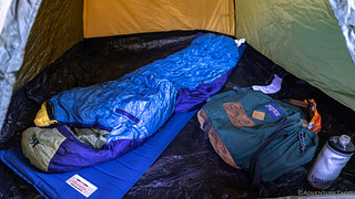
My night on a concrete floor in Panamint City was the worst camping experience of my adult life. Really, there was nothing redeeming about any aspect of it, so entertain me while I complain momentarily, completely aware that this is all my own fault! 
The sleeping bag was a disaster. In fairness to @mrs.turbodb - who warned me of this when I borrowed the bag from her - the fact that I could barely fit my shoulders into the bag, much less adjust my body at all once I was mummified, was super uncomfortable. Add to the fact that it was a 35°F bag - and it was 28°F for much of the night - and it was a recipe for disaster. But hey, the size helped to keep it lighter on my shoulders, right!?
The pad was even worse. I've gotten so accustomed to my Exped Megamat - with its insulated 4" thickness - that sleeping on a 20 year old, 18" wide, ¾" thick Thermarest was pure torture. I'm sure it was better than sleeping directly on the concrete, but not much.
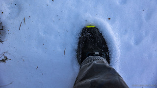
And of course, the night was long and cold. With 14 hours of darkness and snow covering the ground, the thought of losing the little heat my situation retained to take a pee was not at all appealing.
The one redeeming factor - I suppose - was the tent I'd found. Not because it was a great tent, but simply because it provided a small barrier between me and any rodents or insects that could have been attracted to my sleeping bag. Small wins, ehh?

Checking the time became a regular occurrence as I shivered through the night. At 6:00am - still a little more than 30 minutes before sunrise - I realized that I could warm up by getting an early start on the first of several hikes for the day. I'd slept in all my clothes, so it was "easy" - and by easy, I mean a struggle - to extract myself from the sleeping bag, put on my shoes, and be ready to go.


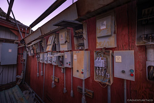
The mill - in operation until 1984 and most notably used for the Wyoming Mine - is the best example of a modern mill in Death Valley National Park. Powered by a large diesel generator housed in the workshop below the mill, the ore was screened at the top ore bin, pulverized in the jaw crusher beneath it, then transported on a conveyor belt to the cylindrical metal bin. From there it dropped into the mill's two-story building, where it was cycled repeatedly through two enormous tumblers (ball mills) and a rake classifier before being treated in a cyanide tank.

Ultimately, I decided to tackle this structure from the top to bottom, opting to get all of my uphill climbing out of the way at the beginning. For now, anyway.

Even after exploring the blasting room and Lewis Tunnel, the sun still hadn't reached the horizon, lending a purple hue to the landscape as I began my exploration of the mill.


Update: A reader of the story related some additional information to me on the tumblers at the Wyoming Mill, which I thought interesting and worth sharing, as it provides details on the internals of a ball mill/tumbler that I wasn't familiar with:
Those tumblers you pictured at the Wyoming Mill are typically called ball mills. They ordinarily are filled with steel grinding media which crush the ore as the mill rotates and they are lifted up to tumble down when they reach angle of repose and the ore gets pinched between the media and broken up.
One of the nice things about ball mills is that if they are cared for, they hold up really well and many run 100 years or more. As a result, many mills for small deposits are built with used mills and so you often see completely different designs as is the case for these two mills.
Typically, depending on the ore being crushed there would be an optimal length to diameter ratio to size the ground material to the best particle size to extract the desired precious metals. The bolts on the shell typically hold liner plates to prevent the carbon steel shell from being worn by the media. The liners are usually high chrome white iron which is incredibly hard material and these liners usually get replaced periodically as they wear out. They often include lifter bars which help lift the media to ensure that the maximum amount of energy is available for size reduction.
Looking at the installation I suspect the Mine Safety and Health Administration (MSHA) rarely visited this mill since there is no guarding anywhere and I suspect the ladders and handrails were probably pretty lame. Back in the 80s MSHA probably was more lenient than they are today. You would never get away with operating anything that funky today.
The switch gear looks like typical used crap scavenged from other industrial plants (although most of it looks like Westinghouse so it is possible it was new).
Kurt


My exploration of the mill complete, it was time to make a plan for the day. Knowing that I had a lot of ground to cover - perhaps too much for a single day of exploration and the return hike down Surprise Canyon - I decided that there was no sense in playing it safe. Rather, I'd shoot to visit everything, knowing that I could "turn around" at any point if I felt that it was getting too late to head back.
And, given that it'd taken about 6 hours to hike up to Panamint City, I figured the hike down would take about 4 hours - meaning I had to leave around 12:30pm, and giving me approximately 6 hours to explore the side canyons and mines.
Having decided to shoot for the moon, I spent a few more minutes looking at my GPS and planning out the most efficient route. This - naturally - caused my brain to short circuit, but when the haze cleared out, I'd come to the conclusion that I could hike up Water Canyon without carrying all my gear before returning to explore Panamint City. Then, I could start my trek "down" by hiking another 1,100-feet up to the Wyoming Mine and then searching for a partly cross-country route to the Hemlock Mine, spitting me out a mile below town at the mouth of Marvel Canyon.
Water Canyon - Thompson Camp, Curran Mine, Blue Jay Mine
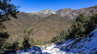
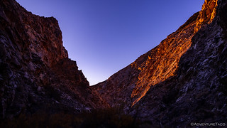
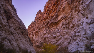
Happy to be hiking without my pack, I made great time up Water Canyon, reaching Thompson Camp just as the sun was peeking over the horizon and lighting the very top of the canyon's spectacular eastern wall. Towering more than 3,000-above the wash in which I walked, this mile-long tableau of granite fins - dating from the Cretaceous period - is the source behind the mineral wealth for all mines around Panamint City.

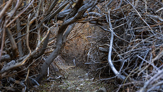
Pushing my way through the willows that line the creek flowing down Water Canyon - notably, the source of water for Panamint City - I found the road leading to the Curran Mine and began my first real ascent for the day - 700 feet in just under a mile.
The main attraction - for me - of the Curran Mine - was the promise of "two desiccated tree trunks serving as a rickety tramway tower standing outside the uppermost tunnel like esoteric modern art." (Digonnet)


Retracing my steps down from the Curran Mine, the sun finally crested Panamint Pass and Sentinel Peak to the south. Immediately warming the air, I finally shed the red puffy jacket that'd kept me alive through the cold night as I progressed a mile further up Water Canyon to the Blue Jay Mine.
While the Curran Mine appeared to be a smaller operation, the Blue Jay was clearly a larger affair. Its main shaft - now collapsed - was well collared with large timbers, and peering in through the rubble, a large, inclined shaft (1 of 5) was steeply inclined and littered with fallen rocks. Unlike the Curran, there were no dramatic colors on the walls - it was poorly mineralized.


I have to admit - as I looked out over Panamint City from high above - that I felt pretty good. Only 90 minutes after sunrise, I'd already explored an entire side canyon. Maybe this overly-ambitious schedule I'd cooked up would actually work out!
And so, oblivious to the realities of the rest of my day, I headed back down to explore the town of Panamint City.
The Town of Panamint City
As often seems to be the case, my route back into town from Water Canyon wasn't quite the same as my route out of town had been - a function of leaving via a lower road on the south side of the creek and returning by a higher road to the north. This - I hoped - would spit me out near a few cabins I could see on the hillside, saving me the trouble of walking down to the center of town and back up again.


As I hoped, the road passed by all three of the cabins I could see from the center of town; none of them in great shape, but all of them worth exploring. Each of them weathered and in varying states of disrepair, their water-stained siding gleamed in the morning sun as I made my way from one to the other in turn.


After enjoying the view from the bench of the overflow cabin for a few minutes - something I could have done for much longer had I not over-planned my stay - I gathered up my camera gear and descended the final 60 feet so I could poke around the buildings that make up the city center.

The story of Panamint City began late in the fall of 1872, when veteran prospector Richard Jacobs and his partner Robert Stewart trudged up a nameless canyon in the western Panamints, hoping to locate the source of silver float Jacobs had spotted earlier in the lower canyon. Back then, this was rough, unchartered wilderness. Ballarat, Lookout, Skidoo, and most other local legends were not yet on the map. Only a handful of emigrants had set foot in Panamint Valley. But both men had a keen eye for minerals: Jacobs had spent much of his life prospecting in California and Mexico, and Stewart had prospected up and down Panamint Valley for a decade. Deep in the mountain, the canyon flared into a valley so unexpectedly green that they called it Surprise Canyon. It was there, on the pine-dotted slopes, that they discovered the silver-bearing quartz veins they had been looking for, which would soon give birth to Panamint City. When they returned to civilization a few days later, pushed back by an early snowfall, they found that their samples assayed hundreds of dollars per ton. Anxious to secure their discovery, they returned in April 1873 and claimed the richest ground they could find. Jacobs optimistically named his the Wonder of the World, and Stewart located the Stewart's Wonder.
The discovery occurred in the wake of rich silver strikes at Cerro Gordo and Nevada's Comstock, and it sparked wild speculation. Throngs of prospectors and miners rushed to Surprise Canyon. By the end of 1873 every square foot of ground that showed the slightest promise had been claimed, and the Panamint Mining District was in place. Jacobs was first to develop his property. In association with a few friends, he incorporated the Panamint Mining Company in November and hired no fewer than three dozen miners to sink exploratory shafts. The following summer he hauled a second-hand mill to his mine, hoping to reduce his ore to a hefty $1,000 per ton.
Mining didn't start in earnest, however, until Nevada senators John Jones and William Stewart stepped in. Both men had just made a fortune at the Comstock Mine, Jones as a superintendent and Stewart as a lawyer. In the summer of 1874, they and a lawyer partner, Trenor Park, purchased almost every claim in sight, as well as Jacobs' mill, for about $250,000. This high-stake acquisition triggered a second, even wilder rush, one of the biggest the Death Valley region ever witnessed.Hiking Western Death Valley National Park
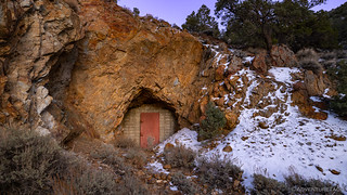
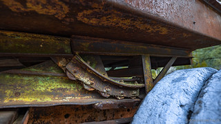
Several buildings are clustered at the crossroad on the valley floor - a two-room plywood cabin with glass windows and a one time working tap that's earned it the nickname, "Panamint Hilton," a large workshop constructed of steel beams, and a quarried stone quadrangle where I'd shivered away the night, just a few hours before.


Ultimately, I must admit to being a little underwhelmed with the cabins of Panamint City proper. Certainly, running into any of these structures elsewhere in the desert would have been a welcome discovery, but I think I'd built up the greatness of this ghost town to be something more - a series of shelters still in nearly-livable condition, rodent-free and complete with running water. Of course, time - and visitation - takes its toll on places like this, and today, these cabins are like many others you'd find elsewhere in Death Valley.
Still, the experience itself - difficult as it was - was awesome. 10/10 would do again! 
The Wyoming and Hemlock Mines
While planning my trip to Panamint City, two elements had really piqued my interest. The first - which I'd already experienced and had checked all the boxes - was the smelter smokestack that stands tall above the town. The second - visiting the Wyoming mine on the hillside south of town - promised an encounter with a historic aerial tramway, and the challenge of finding a historic connector trail to the Hemlock Mine, the districts largest producer.
Even during planning, I was acutely aware that the Wyoming and Hemlock mines might be unattainable goals on such a short trip. Others - much more experienced than me (ahem, Digonnet) - allot four days to cover the ground I was attempting to traverse in 36 hours. Yet, at 10:55am - only a couple hours before I'd planned to head back down Surprise Canyon - I made the decision to start up the 2-mile-long trail toward the Wyoming Mine. Surely, climbing 1,100 vertical feet of snow-covered road, photographing two levels of Wyoming Mine workings and aerial tramways, finding the historic connector trail, and hiking an additional 3.7 miles to the explore and photograph the Hemlock Mine - all before rejoining the Surprise Canyon trail a mile below Panamint City - could be done in that time.
Remember kids, if you ignore reality, you can create your own. 

Knowing I was pushing it from a timing perspective, I reached the lower workings - 700' above the town center - in less than half an hour. Here, a shed built in the 1970s housed a blower that once ventilated the 1,000 foot-long tunnel - the old canvas ducting disappearing into darkness as it clung to the wall.

It was significantly warmer in the mountain than it was outside, snow covering the blower shed at the mouth of the adit.

This lower-level working was also where the aerial tram towers - built in 1875 and refurbished in 1925 by the Panamint Mining Company - that I'd been anticipating were located, though they were just out of sight of the workings, making me thankful that I'd re-read the description of their location just prior to embarking on this hike.

Continuing up the side of the mountain, I covered the final half mile and 400 vertical feet - to the upper workings of the Wyoming Mine - in just under 15 minutes, my puffy coat unnecessary, even in the snow-covered, shady confines below Sentinel Peak.
Here at the end of the road are an interesting mix of modern and historic remains. Guarded by a modern generator on rubber tires, a rail track links the historic tunnel to a trestle bridge, where the ore was dumped into the aerial tramway (now collapsed) before being lowered 1,100 feet to the mill in Panamint City.

Unfortunately, the historic tunnel - accessible until at least 2019 - has collapsed, leaving only a narrow gap at the top of the collar from which one can peer into the darkness. Here, now trapped and inaccessible, two functional ore cars are still parked inside the tunnel.
Oh, how I'd have loved to push one of those carts!
My exploration of the Wyoming Mine complete, it was almost exactly noon, and I had a decision to make: head back down the way I'd come, skipping the Hemlock Mine but giving myself a good chance of descending Surprise Canyon before sunset, attempt to link together a few historic trails and cross-country scrambles to find the Hemlock Mine.
My heart set on the Hemlock, I pulled up Digonnet's description of the route to convince myself that it was a bad idea:
The Hemlock Mine was the district's largest producer, and it is also the most impressive. It [...] can be reached two ways. The longer but foolproof route is down Surprise Canyon to the Hemlock Mine Road (0.95 mile, on the south side), then up this road [for 1.8 very steep miles up Marvel Canyon].
The second route is the connector trail used in historic days to haul the Hemlock Mine ore to the Wyoming tramway for easier access to the mill. It is a little shorter, and it avoids struggling up the tailings, but it is far less obvious. To reach [it], follow a faint trail around the ridge [from the upper workings for] 0.2 miles, to a wide tailing. The next stretch is a little complicated. Scramble 80 feet up the slope to an even fainter second level trail and follow it south a short distance until it ends. Scramble again another 80 feet up to a third, faint, level trail [which can be followed to the Hemlock Mine].
Obviously - with snow making already faint trails made even more difficult to find - I made the irresponsible decision to push on.
Scrambling over snowy trails and up hillsides covered in ice, there were several points at which I wondered if I'd made the right decision. If I was forced to turn around, the descent was going to be significantly more difficult down the slippery 45° slopes.


It took me an hour - from the time I left the Wyoming Mine - to reach the lower tailings of the Hemlock.
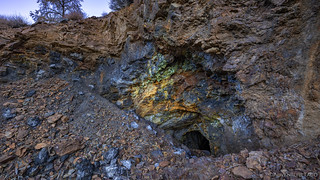
What is particularly impressive here is the height of the two tailings, which are one above the other. Combined, they completely engulf the ravine over an elevation drop of over 350 feet! My plan had been to explore the main tunnel - located above the lower tailings - which follows a smooth vertical fault plane on one side and is solid quartz on the other, eventually opening to a cathedral-like chamber with a high ceiling streaked in reds and yellows.
Unfortunately for me, the tailings - which are difficult to climb on the best of days, the pea-sized gravel making upward progress painstaking at best - were covered in two inches of ice, eliminating any chance of reaching the top.

In fact, initially I wasn't even sure how I'd make it down the tailings to the road - and I momentarily considered backtracking the entirety of the way I'd come - until I found a 10-foot length of small-guage rail track that I could use to both crack the ice and as a brace to "safely" make my way down the sheet of ice.
It was 2:00pm when I reached the bottom of the tailings and breathed a huge sigh of relief. After sending a message on my inReach Mini that I was no longer "doing something sketchy," I took a moment to soak in the spectacular views of the landscape below.

It was a 2:30pm - couple hours later than I'd hoped - when I reached the mouth of Marvel Canyon where it joined the Surprise Canyon trail that I'd hiked in the opposite direction just 24 hours before.
Racing Down Surprise Canyon
With only two hours until sunset, I knew that I was really going to have to hoof it in order to avoid navigating the slippery Suprise Canyon narrows in the dark. Grabbing the last of my trail mix and a few slices of dry mango - I hadn't brought much food, knowing I'd only be gone for 36 hours - from my pack, I picked up the pace as I raced the sun through the upper elevations of the canyon.
As had been the case on the way up, a maze of paths crisscrossed the wash and while I generally seemed to follow my original route, there were places where I found entirely new experiences.
With just over six miles to cover - I'd joined the Surprise Canyon route one mile below Panamint City by hiking six extra miles to the Wyoming and Hemlock mines - things were looking good as I maintained a 4mph pace through the upper canyon. Even as I reacquired my Muck boots - thankfully unoccupied by local riff-raff - for the wet section, I knew that I even if I didn't make it back technically before sunset, there would still be plenty of light, such that I wasn't walking in the dark.
I'd made it. Tag, you're it!

While exploring Surprise Canyon and Panamint City, one of the coolest places I found was "The Castle," a cabin nestled near the base of Stewart's Wonder Mine, up Sourdough Canyon. There, historic information was plentiful. I scanned two of the more interesting - to me - items.
More Panamint City Archives
The label on the 55 gallon drum is Standard Oil of California
Nice! Thank you Desertfox, that is obviously correct! I've updated the story - another win for the internet (which seem to be more and more rare these days ?)
You might try heating up a couple of rocks to help with the cold. They stay warm for quite a long time inside your bag.
Yes, that's a great trick. The other thing that works pretty well, I've found, are warm bottles of water. Even one that's "not warm" when you bring it in will warm up and then be a little heater through the night for the feet! And in this case, I was basically sleeping on rocks anyway, so I wouldn't have been any less comfortable with rocks in the bag with me, hahaha!
Another fine and interesting adventure with excellent photos, almost like being there, thanks for sharing place that I wouldn't otherwise be able to visit. BTW - Remind me not to invite you an a backpacking trip, LOL! You did have benefit of a roof and flat base. When we did our trips over the crest of the Eastern Sierra (Mt. Whitney, Rae Lakes, etc.) it was 60 lb packs and a small 2 person tent and everything would freeze (except us) the minute we lost direct sun. Of course we had mummy bags good to -30 or so and dense (1/2" thick) Army surplus pads to soften laying on the bumpy rocks. So we didn't get cold at night. BUT did have to think long and hard before making a bathroom break in the middle of the night but sometimes you gotta do what you gotta do! LOL!!! Those were the days!
Well, I think that with a little more preparation and the right gear, backpacking wouldn't be all that terrible. I do remember doing it quite a bit as a kid (Scouts) and loving it. Plus, there's a lot of good stuff to see that just isn't achievable in a single day, and I get that.
But hey, I like to complain on the internet just like everyone else dangit! ?
YES, I think many of us are guilty of complaining on the Internet, LOL. I suspect that my old bones would be screaming bloody murder if I were to sleep on the cold, hard ground again!
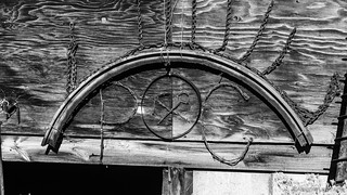
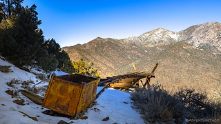
What is the item on the left? Inverted leg to old stove? Too stay warm at night, I use my battery powered coat on low heat. Stays kinda warm and fights that chill a bit. Great exploring!
I think you hit the nail on the head with the old stove leg. Obviously I'm not spending enough time upside down to figure that out! ?
A battery powered coat you say? What is this magic, I must investigate!
Another fine trip report, but one I would not want to repeat, at least at the pace you set!
BTW, last year you wrote of a trip in or near DV, where you climbed up to several mines, but then had insufficient time or energy to hike down on the other side 1500 ft to what you thought was a more pristine site. I think you approached up the east side of a ridge, but did not drop down to the west. Can you point me to that trip?
Hey Anthony, Glad you liked the trip report, as always!
As for a trip report where I left a 1500 foot climb undone... I can think of a couple (thanks a lot for pointing out my propensity to wuss out ?).
Let me know if one of those is the one you're looking for (you can find "1500" in the text of either one), and if not, I can keep searching.
Thanks for the tip. I was indeed thinking of the Eastern Sierra 3 page. I say again, I am constantly impressed by the effort you put in to produce your beautiful photographs. Your photography page shows that you are anything but casual about getting your images. Just your stopping constantly and running back to shoot your Tacoma in situ would be enough to discourage many of us, but then you go home and spend more time in post processing than on the trip. Wow. Well done!
That eastern Sierra trip and your most recent page describe what I'd would have called epic hikes, even back when I was a super hiker. When combined with "death drives" back and forth to Seattle, I don't know how you do it.
Carry on, but stay safe. When I take off for the hills my wife's last words are always "Don't do anything stupid". The Redcrosse Knight encounters a sign saying "BE BOLD, BE BOLD, BE NOT TOO BOLD". Your last adventure on the high angle scree to the tramway and trestle (https://adventuretaco.com/into-the-inyo-inyo-east-1/d) tells me you should remember those words, too.
Yes, yes I should!
I reasonably recently (about a year ago now) picked up a Garmin inReach Mini because of my tendency to do “bold” things. Really though, I’m pretty safe in my decisions around those things, really only opting to do the ones that I feel like are well within my abilities, and coaching others to make sure that what they do be within their abilities as well. An interesting one for me was a series of dry falls in another Death Valley Canyon, where I ended up ascending and descending several times in order to ensure that I was comfortable in my ability to downclimb when I was done exploring. If you’re curious, here’s a direct link to my guidance, and also the entire trip.
And thanks so much for the kind words on the photography. Luckily for me, I (mostly) enjoy it all, since it means getting out into the wild.
Awesome coverage of a neat hike. I can't see myself ever hiking in there, so this is probably as close as I'll ever get! We'd be so far from home, there is no way we could leave an empty vehicle at the trailhead. I'd be terrified to leave my truck and all of my gear there for an extended period. This is the first comment that I've left, but I'm really enjoying your trip reports.
Thanks Trey! Glad you enjoyed the story, and I hope you have a chanced to check out some of the others (or more of them, as it sounds like you've already found a few!)
As for leaving a vehicle at the trailhead - I hear your concern for sure. So far, I've been lucky and not had any issue. My hope is that folks who are out there in these remote areas have the same respect for others' belongings that I do; that we're all out there to just have a good time. Anyway, I say that only to provide a bit of reassurance to you that you can leave your stuff the vast majority of the time, and everything will work out just fine. Otherwise, you miss out on so much opportunity to see things that are "away from the road," which is where all the best stuff is!
Stay safe and have fun out there!
As somebody who has enjoyed many adventures in the past, I really enjoyed your story and hike descriptions. Thanks for sharing them with us.
So much fun but the cabins and stuff were a bit too new, sorry about that. But the thing you wondered about was as someone has already said, was definitely a stove foot.
Wow! This trip report and photos are fascinating. I've always heard Panamint City was practically washed away. You're description of the long miserable night reminded me of several times camping in Mammoth (elev. 8000' - 11000') where I experienced the same. Its possible for even the most experienced outdoorsmen to have altitude sickness. You're hike description included several high risk factors. A rapid ascent, a high degree of physical activity, previous lack of sleep, possible mild dehydration, your gender. An often overlooked symptom is trouble sleeping. I remember learning in Scouts that many sleeping bags work best if you aren't wearing much clothing as the body heat trapped in your clothes doesn't allow them to work correctly.
Thanks Joe! Most of Panamint City was actually washed away, but over the years it was rebuilt a few times, so what's remaining now are the most recent (but still old) additions.
As for altitude sickness - it's never been an issue for me, and I don't think it was a problem on this trip (Panamint City isn't all that high - even the highest mines were only ~7500' or so). The real issue was that (a) it was cold, (b) I didn't have a bag or pad that fit me b/c I am a wus when it comes to shoulder packs. Of course, the bag and pad were *way* better than what I used when I was a scout, so that just suggests that the real reason is (c), I am a wus. ?
Is there water to filter there? and what is the best time of year to backpack there?
Hey David, I can only really answer in the context of when I was there - late fall. There was filterable water at that point, so it would seem reasonable that there'd be filterable water other times as well. At the very least, you could filter water from the springs on your way up (see Hardest Hike Ever | Panamint City #1).
As for the best time of year to hike - that's totally up to you, I suppose. I'd say away when it's snow covered, and personally I don't visit the area in the heat of summer, so for me, that leaves fall and spring. I can imagine that late spring would be quite nice - flowers blooming, etc. - but I've not been at that time myself.
Hope that helps!
Does anyone have a clear map or gps routes to guide me? I tired this a few years ago and got lost after the falls. Never made it. I wan to try again. Are there any groups that go up? I would feel safer going with others.
Hi Anna, where'd you get lost on this hike? There's only one route up the canyon, and there are plenty of books that describe the route. Personally, I'd suggest Hiking Western Death Valley National Park. Have fun up there!
I just did this hike for the 3rd time, because I wanted to take a bath in the hobo hot tub at the Castle... which I somehow missed on my first 2 visits. The road was washed out from the summer monsoons, so I had to start an extra .75 mile from the trailhead -- talk about adding insult to injury!
Like you, I *HATE* backpacking.... but I had to spent the night if I wanted enough time to take a bath, so I lugged a 25-lb pack up there with me. UGHHH!
Found your awesome writeup as I was Googling the distance -- can't seem to find a straight answer online as to the length and elevation gain of this MONSTER hike. Whatever it is... it's a BEAST! But I'll bet you anything I end up doing it again some day :-p
The third time - nice! Like you, I found a lot of conflicting info online as to distance/ elevation, so here's how I ended up with my numbers.
I think a lot of folks use the length of surprise canon (7.2 miles) and the elevation gain of the entire canyon 6,400-1,700 feet to come up with "more impressive" numbers.
How was the weather/snow (if any) up there, and when were you there? I was considering my second trip up in the next couple weeks, this time to poke a little further into some of the adits, and maybe trying to make it to Panamint Pass and/or Sentinel Peak.
Thanks! There was no snow (this was Dec. 3-4), but as mentioned, the road was washed out and the trail was maybe even more messed up than usual... and more overgrown/more bushwhacking. (FYI...I was overly cautious about the road -- after hiking up, i saw that I almost certainly could have driven to the trailhead.)
On our way up, we encountered a group of 5 guys coming down... but reading the trail register in the Castle, it looked like no one had been there since September! I saw where people do it as a thru hike -- up Surprise Cyn, over Panamint Pass, then down Johnson Cyn. It would be interesting to follow the route Hungry Bill took to deliver his produce from his ranch to Panamint City, but.... with my aversion to backpacking, I'm not sure I'll ever do it!!!
Anyway, despite the bushwhacking, it's a neat time to go up there because the storm also probably washed up all kinds of new detritus... Good luck!
Nice! (and thanks for the up-to-date info)
I think a lot of folks miss the Castle entirely, and of course, not everyone signs the register, especially if they've found the one in "PC proper," so maybe that's what was going on.
I've been up Johnson Canyon to Hungry Bill's, but the trail getting there is tough to follow, and becomes significantly harder past Hungry Bill's orchard. I too have thought it'd be neat to retrace those steps though, so maybe someday I'll get up the gumption to wear a pack for what is certainly a multi-night adventure.
Will keep an eye out for video that I assume is coming! As always, enjoy yourself out there and maybe someday you'll happen on a green Tacoma, or I'll spot a white 4Runner. 😉
We're bound to run into each other out there one of these days!
Not sure I am up for this hike, but I am sure intrigued. Hmm, maybe spring or fall when a featherweight sleeping bag will suffice. But if I don't go, your trip reports are like walking in your boots, and did bring back memories of shivering in too light of bag.
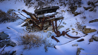
You find such interesting old mining equipment, that I find it a fun challenge to identify. Pretty sure that Wyoming Mine generator is a Gardner Denver air compressor. A little customized with air tanks relocated.
Please, identify away! I love it when this stuff gets IDed, and I'm always happy to add those IDs to the stories! Thanks!