
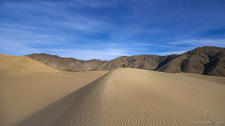
Unlike the previous morning when we slept in, I had my alarm set for early-o-clock so I could catch the sunrise from our camp site at the north end of Panamint Valley along the Big Four Mine Road. Oh, and so that we could get an early start on our 9-mile hike to the Panamint Dunes!


The tent was stowed, breakfast consumed, and our day packs strapped on by 7:30am, just a few minutes after sunrise. Both of us made a mistake of wearing too much clothing in the only-chilly-for-about-five-minutes morning as we set out to close the four-mile gap between us and some of the most remote dunes in the park.


Despite the distance, the walk to Panamint Dunes is mostly flat, rising only 750 feet over the course of the four-mile alluvial fan on which the dunes sit.
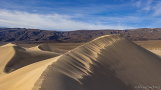
Sit however is a bit of a misnomer - the Panamint Dunes are actually moving. Slowly of course - at something like 2.8 feet per year - but moving, nonetheless.
Geologists have managed to find clear evidence of the dunes' imperceptible migration. Because of their location part way up an alluvial fan, the dunes form a local barrier across the fan's sloping surface. During a flashflood, debris flows - boulders, gravel, sand, and silt - washed down from Hunter Mountain normally spread out over a wide area of the fan. However, the portion of a debris flow intercepted by the dunes collects against the dunes' up-fan side and forms a low, flat-topped bench, much like water impounded behind a dam. Flows strong enough to reach as far down as the dunes occur infrequently, perhaps every few centuries. During this hiatus, the dunes continue to be herded up the fan by the wind, going right over the debris bench and leaving it behind as a mark of their passage. Subsequent flashfloods create other benches, higher up the fan, but the older benches are protected from them by the screen of up-fan dunes.
Like giant footprints, at least 15 benches record the steady progression of the dunes across the fans at the north end of Panamint Valley, and they tell us much about the dunes' history. By mapping the location of the benches, one can retrace the migratory path of the dunes and identify their original location. By dating the benches, one can infer the dunes' age and their rate of travel.
The dunes formed at least 6,000 years ago near the shoreline of a drying lake, about half a mile northwest of today's playa. The main source of sand is probably the quartz monzonite that makes up most of the crescent of mountains surrounding the dunes. Since then, they have migrated about 4 miles north-northwest, at an average speed of 2.8 feet per year.
The dunes are still moving. As they reach higher up the increasingly steep fan, the wind will gradually lose its battle against gravity, and they will move more and more slowly. A few thousand years from now, the Panamint Valley Dunes will reach their final resting place, near the foot of Hunter Mountain. Hiking Western Death Valley National Park


It was 9:15am as we made our way out of the last of the brush and onto the sand dunes. Completely void of footprints at this point, we contemplated our next move carefully. As we did, a group of early-20-somethings - who'd driven up to our camp spot the evening before and then noisily made their way out to the dunes to camp - spotted us just as they finalized putting away their tents. Determined to be the first to the top of the dunes, they started running up the ridge. Classy.


As with many dunes, the highest point can be deceiving when viewed from various angles below. As the running had commenced a few minutes earlier, I'd realized that - if the kids were after the highest summit - we had nothing to worry about; they were on the way to the second highest point, with no traversable path to the tallest dune!


It was as we were enjoying our small victory - competition runs deep in our blood - that the wind started to pick up. To this point, though we'd seen dust picked up further south, we'd had almost no wind in the north end of the valley - a great thing as we'd slept through the night - and even now the first few gusts were small. But then - within ten minutes or so - it was blowing a constant 20 - with gusts to 30 - miles per hour. It was - at times - hard to stand.


It turns out that the best place to be in a sand dune windstorm is at the very top. There at least, the sand is pulled back down by gravity, and while sand still gets everywhere, less of it is falling into your hair and down the neck of your shirt. Still, after waiting 15 minutes or so, even we had to descend into the vortex - though we did our best to hurry our way out of the sandblast zone.

The hike down the dunes was faster than up - each sliding step pushing us forward rather than pulling us back. Along the way we marveled at some of the windblown formations in the dunes - the graceful curves interrupted by geometric lines.


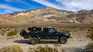
We arrived back at the Tacoma - and our camp site - just after 11:30am, having completed the 9-mile hike in just under five hours. Our first order of business was sand removal - from every piece of clothing as well as our hair and bodies - it was everywhere. Then, it was time for lunch.
There's almost nothing better than a tasty sandwich, salty chips, and cool water when you're out in the desert - and we enjoyed ours with a view of the dunes before climbing into the Tacoma for what would turn out to be a much longer drive than we'd expected.

(Note: Does Racetrack Playa's Grandstand have a similar story?)

Our last stop - and a short one at that - before pressing the skinny pedal with near reckless abandon, was at a trench that I spotted along the side of the road. Wondering what it was about, my co-pilot was quick to inform me that she'd read about it in the Death Valley bible.
This trench - one of several - was dug by geologists to analyze the pluvial history of the valley. A few feet beneath the surface, they uncovered a thin layer of dark, peaty soil that formed 2,000 or 3,000 years ago when the playa was submerged by a shallow lake. Lush marshes livened by aquatic birds then flourished around Lake Hill. The peaty layer still holds pollen of the sedges and cattails that grew at these prehistoric marshes. Hiking Western Death Valley National Park.


With only about three-and-a-half hours of daylight left and a four-hour drive in front of us, we already knew we weren't going to make it camp before dark - again. And, that didn't take into account the fact that we planned to stop in the Searles Valley near the town of Trona to check out the brightly colored holding ponds that are mined by the Searles Valley Minerals Company.

Well, it turns out that upon reaching the Searles Valley, it was nothing like I'd imagined. A combination of wind-blown dust and the pollution from the mineral company made the town of Trona look like a war zone. Not only that, but it smells... terrible. This is the kind of place where one suddenly understands how respiratory issues can plague someone who grew up here, for life.

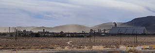


Wanting to spend as little time as we could in Trona, we quickly discovered that any hope of seeing the colorful pools of water visible from satellite was just an illusion - even if the entire area hadn't been covered in dust, the entire lakebed was off-limits, and we'd have needed a flying camera to get the right perspective anyway.
And so, we exited town to the south, more than a little bummed that we'd opted for the long way 'round to our planned destination for the evening. Still, I suppose that if we hadn't, I'd always wonder about the Searles Valley, and now I know. Plus, our route did allow us to stop at the Trona Pinnacles on our way out of town.

The pinnacles consist of more than 500 tufa spires, some as high as 140ft, that rise from the bed of the Searles Basin. Varying in size and shape - they are composed primarily of calcium carbonate - they are formed where a spring is submerged under a desert lake. If the spring water has traveled through limestone, the calcium carbonate precipitates as tufa when it enters the alkaline lake water. Little by little, a mound of tufa forms around the spring's outlet. Algae growing on its surface help fix new calcium onto it. Over time, the mound can evolve into a spire, as spring water is fed upward through the spire's hollow core and deposits tufa higher and higher. Of course, the spires generally remain under water -until the lake subsides or dries up. These are the same types of formations that can be seen at Mono Lake.

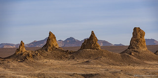
Like the town, we didn't linger long at the Trona Pinnacles. They reminded me of what Alabama Hills has become in the last several years - visited to death. Conceptually fascinating in a more remote and pristine setting, it's clear that too many people have climbed on, driven around, and pooped next to these once spectacular spires. It's a fine line we walk when places like this are made accessible to the public.
It took us four more hours to make our way south, west, and finally north again to reenter Death Valley at the southern end of Harry Wade Road. Ready for dinner we quickly found camp under the light of a nearly full moon and less than fifteen minutes later we were enjoying our tacorritos with an amazing view of the next day's adventure: the Ibex Dunes.


Out here on the edge of the wilderness, we were happy.


Great story and photos as always! Next time you find yourself in Trona with inclement weather, duck into the Old Guesthouse Museum run by the Searles Valley Historical Society. When I was there several years ago, they had a section of the Epsom Salts monorail, and many other interesting mining information and exhibits.
http://www1.iwvisp.com/svhs/
Awesome, thanks for the tip Curt! Man, I wish I'd known that there was a bit of the Epsom Salts monorail there, I'd have loved to have seen that, after seeing some bits of it when we hiked out to Crystal Hills!
Yep, that's why I mentioned it! The Epsom Salts monorail hike as been on to do list for a few years, maybe I'll get there this year.
Maybe I'm alone here, but I find Trona delightful. I mean it's a desolate shithole for sure, but there are plenty of folks that would use that term for the less industrialized valleys we cherish nearby as well. I love the fact that it's a functional mining community in the 21st century. The little restaurant is worth a stop too. Plus there's an airport and a golf course, all right by a lake. That's practically a resort in my book!
Last time I stopped by, I was trying to air up at night after my air compressor setup had rattled itself apart on the trail. I started by somewhat needlessly topping off the tank so that I could demand free use of the air compressor, but as I pulled over to unreel its hose and uncap the tires, a truckload of sketchy-looking people rolled up like usual, with maybe 6 adults piling out of a beat-up single-cab pickup truck and its bed. Most of them headed in, while a few lingered by their truck watching me. Whelp, I figured, it was no longer worth the trouble to march into a now-crowded convenience store to stand in line just to save $1.00 on an air compressor cycle (and I'm honestly still on edge about the whole Covid thing too). I had a handful of quarters in my pocket anyway, so I just started feeding them into the machine. As the first one clinked through the mechanism and plopped to the coin box, I looked up to see a somewhat intimidating character headed my way swiftly and with purpose. I'm going to be honest, this was not a comforting sight, although that might have been due to hanging out on TW and hearing things like this:
I took a few steps back so I wasn't straddling the air hose as this guy closed the gap. He was wearing a tattered hoodie and loose-fitting backpack, but don't think it was filled with textbooks or a graphing calculator. Perhaps I offered a greeting, my mind racing, as he reached down to effortlessly unlatch the compressor housing and hit the manual cycle start button for me.
Silence.
"Thing's still broken, sorry man."
I guess it had been broken for a while! It was pretty nice of him to run over and save me the disappointment of wasting three more quarters to find out. Or heaven forbid, venturing into the shop to ask.
Anyway... a delightful town!
Edit: And did I mention.... AFFORDABLE?
Better start saving those quarters!
i noticed that you said you wanted to get out of Trona as soon as you could. I agree, i went through there many years ago and i re-named the town "Trauma". UJ