
Burning Man. I've never been and don't really ever feel like I will have the need to go, but the location - a big flat playa in the middle of a bunch of wilderness - has always intrigued me. Then, while I was researching side trips for our trip along the Nevada Backcountry Discovery Route (NVBDR) last year, I stumbled upon a few photos of High Rock Canyon, just north of the Black Rock Desert - wow!
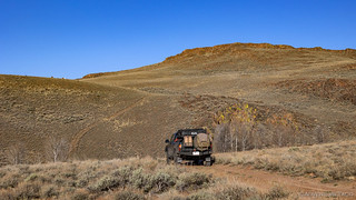
The desert turned out to be too far from the NVBDR for us to make the trip at the time, but ever since it's been nagging at me to check it out. So, with a few days available, @mrs.turbodb and I decided that we ought to check it out. Bonus points that it was only 11 hours away! It was 7:30am when we climbed into the Tacoma, and it was 6:30pm when we headed east through Cedarville and only a few minutes later when we found ourselves turning into our first stop - the Massacre Ranch.

This is a much nicer, more modern cabin, than I was expecting.

Turns out this cabin is one of a series of cabins in the area maintained by the BLM, and is used regularly on a first come, first serve basis.
Early stories suggested that forty settlers were killed near this location, but later (more reliable) studies doubt whether any massacre actually occurred here. Whatever the case, everything there now is much newer, and with the sun setting over the horizon, we continued south towards our designated camp site.

Time to get to camp while we still have some light.
We arrived at Stevens Camp to dwindling light, but way earlier than we usually make camp on the first night of a trip - a fact we were both thrilled with. At the head of Upper High Rock Canyon, we found a level spot and setup the tent - leaving our investigation of this also-very-nice-looking cabin until morning.

A small stream gurgled nearby, lulling us to sleep.
We slept well, the temperatures in the upper 30s and the breeze slight enough to be inconsequential. Unbeknownst to me, @mrs.turbodb had set her alarm for 4:00am - this area having been designated as the fourth International Dark Sky Sanctuary in early 2019. As she scrambled to silence the ongoing racket, I took a quick look out the tent door and made one simple statement: "I think the moon is still up, look at our shadow." And with that, we went back to sleep. There would be no getting up to see the Lyrid Meteor Shower, since the dark sky was... rather light.
Well, back to sleep until my alarm went off at 5:30am - just in time to catch the orange hue of sunrise on the horizon.

Desert sunrise.

15 minutes later, the few clouds in the sky picked up some good color.
At this point, I was awake, and I knew we had a full day ahead of us, so I threw on my clothes and climbed out of the tent to look around a bit. The area around Stevens Camp was reasonably sagebrush-y, so I made my way up a little hill behind camp to see if I could get a better view.

Nestled in a valley.
I wandered around for a bit - mostly investigating a spring I found on the hillside - before heading back down to camp to show off my discovery and start poking around the cabin. It was good timing too, because as I arrived back in camp, I found strawberries and Cheerios being prepared on the tailgate!

A shed antler; left for a future explorer to find.

Nicely maintained. The small extension on the right is even a shower with hot water!

Palatial accommodations. I've never seen such a well-maintained cabin. Main living space, a shower, and two additional bedrooms.
A sign in the cabin gave a bit of history
History of Stevens Camp
The site of Stevens Camp was probably first seen by white men in December of 1843 when an expedition led by John Charles Frémont passed through High Rock Canyon. A few years later in 1846, another expedition of 15 men led by the Jesse Applegate, Levi Scott, and David Goff passed through High Rock Canyon. These men were exploring for a new route into Oregon, and they established a route that was known as the South Road to Oregon, or the Applegate Trail. This route was used for a couple of years by Oregon bound emigrants, and then in 1849 by thousands of California bound gold seekers. After 1849, use of the trail waned.
In the early 1860s, ranchers started using the area. This prompted the U. S. Government to survey High Rock Canyon in 1874. The surveys identified a spring in Section 3 of Township 41 North, Range 22 East that eventually became known as Stevens Spring. In 1880, parcels of land around well-watered sites in High Rock Canyon were transferred to the State of Nevada. Nevada, in order to raise money for public schools, soon offered up the parcels for sale, including Stevens Spring.
The parcel around Stevens Camp was first purchased by employees and relatives of Eliot Crutcher. Crutcher was working with his uncle, Dr. Hugh Glenn from California. Glenn already had huge ranches and wheat farms in California, but was expanding his operations into Nevada and Oregon. Crutcher, at the behest of his uncle, established a large ranch they called the Black Rock Ranch. By 1884, the Black Rock Ranch owned 7,568 acres in Humboldt and Washoe Counties, and was running over 5,000 head of cattle on these lands and the adjoining open range. Hugh Glenn was murdered in 1883 and his heirs decided that they wanted to sell the Black Rock Ranch. It was purchased by another large California ranching operation that was expanding into Oregon and Nevada—the Miller and Lux Corporation. Miller and Lux expanded their holdings at Stevens Camp, as well as other locations in northwestern Nevada, eventually becoming the largest local ranching operation.
During these early ranching years Stevens Spring was used to water cattle. Also the grasses and other vegetation in the meadows below the spring might occasionally have been harvested for hay, and the spring site itself was used as a campsite for buckaroos out riding the range. The spring eventually became known as Stevens Camp.
The Miller and Lux Corporation pulled out of Nevada in 1926, putting the Stevens Camp property up for sale. It was initially sold to two California ranching brothers, H. J. and F. J. Powers, and subsequently passed through a number of owners.
In the 1950s, Stevens Camp was owned by Ernest L. Ford, better known as Tennessee Ernie Ford. Ford was a musician and entertainer, who started his career in 1939 as a radio announcer in Tennessee. He relocated to California after serving in the Army Air Corp during World War Il. In California, he made the transition from radio announcer to television, and recorded some of his own music. He had a number of hits, including his best known song "Sixteen Tons." He spent much of his spare time on a cattle ranch, which he started near San Francisco. Tennessee Ernie Ford built the cinder block building currently standing at Stevens Camp.
In the 1970s, the property was owned by local rancher Sam Jaksick. Mr. Jaksick wanted to enlarge holdings on nearby Forty-nine Mountain, and arranged a land swap with the Bureau of Land Management (BLM). The BLM acquired Stevens Camp in this manner in 1975.
We looked around as long as there was cereal in our bowls, and then a quick wash-up and pack-up of the tent were all that stood between us and getting under way.
Heading south on the Applegate Trail into High Rock Canyon.
Interestingly, our plan for the morning started off with us looking for a locked gate - something we generally try to avoid. Of course, in the back of our minds we hoped it wasn't locked, but all the route planning I'd done prior to departure was clear: the road is closed from Feb 1 to the second weekend in May to protect the historic Emigrant Trail and the local wildlife during breeding season.

Entering the canyon.

And there's the sign.
And so, we turned around, this point marking the start of a loop we planned to do through the region, the end of the loop terminating at - we expected - a locked gate at the other end of the High Rock Canyon where we planned to hike part of the canyon on foot.
Retracing our steps, we made a quick stop at a T-rail marker we'd seen on along the side of the road. Over 700 of these have been placed along the Oregon and California Trails by the non-profit Trails West, and we first discovered them on our Nevada BDR trip.

APPLEGATE TRAIL - LEAVING HIGH ROCK CANYON
Next came to a beautiful meadow of fine grass and well watered. It was indeed a cheering sight...we could, once more, see daylight, which was pleasant after being shut up so long in dark defiles. - B.R. Biddle, 1849
At that point, we'd planned to continue back out past Stevens and Massacre Camps, but we found a side road that appeared to go through and decided we might as well give it a shot!

On our way!
This initial part of the route was rather bland - lots of sagebrush as we wandered through the landscape. Eventually we found ourselves on NV-34, a nicely graded - though dusty - gravel highway that would take us to Gerlach and the Black Rock Desert, save for a few interesting stops along the way.

Wheeeeee!
Despite the nicely graded road, my perception is that not much traffic passes this way, save for the time right around Burning Man, and perhaps a few ranchers out to check their growing steak supply. Along the route, an old cabin caught our eye and we pulled over for a look.

Nameless homestead.

The stove could use a refresh.

Current residents.
A little further along, we saw the first of what would be dozens of wild horses along our loop. In fact, we may have seen more horses than cows on this journey, and they all looked a little lean after winter - their long-haired coats shedding for summer, and ribs poking out here and there as green shoots of grass made their welcome return with spring.

"I'm gonna stick close to momma, thank you very much."

A watchful eye.
Continuing south, the Lund Petrified Forest was our next stop along the way. Once dominated by a forest of towering giants, this area was once part of the Leadville Mining District. At that time, George W. Lund was enraged as he watched uranium prospectors blast and then bulldoze tons of petrified wood onto trucks for commercial exploitation. He spent many years and much of his own money organizing meetings writing letters and posting signs, and on occasions even made trips to the Nevada State Legislature to lobby for legislation to preserve and conserve areas of petrified wood in Nevada.
Scientific investigation has revealed more than 250 mappable occurrences of petrified wood remains, though only a few large specimens remain - the two most prominent now encased in chain link fence to prevent collectors and tourists from dismantling what little is left. It was - certainly - a sad sight, upon our arrival.

This trunk 8-foot diameter was petrified in an upright position, some 15 million years ago.

Tight growth rings, forever preserved.
Our mood a bit dampened, we didn't spend much time at the petrified forest, instead opting to continue south into the wide open landscape, its serene beauty working its magic to re-raise our spirits.

Wide open spaces.
Soon enough, we came to a short spur that would take us to (what I'd noted as) a ghost town from the Leadville Mining District days, but really turned out to be the ruins of a mining camp. It was quite obvious up on the side of the hill, and we easily made our way up to the tailings pile, where we hopped out of the truck to look around.

Onto old mining roads.

Modern day parking pad.
As we wandered around, there wasn't much left of this camp to see. Likely a combination of relatively easy access, as well as the extreme weather that rolls through this area during the winter, not much remained - only a single corrugated metal structure, wooden supports for an old rail line, and a car that had seen happier days.

Interestingly, two doors on this structure.

Trestle to cart tailings to the edge of the pile.

Still less rust than a 1st gen Tacoma. 
A commanding view.
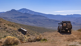
Without much to look at, we soon headed back to the truck and retraced our steps to NV-34, the snow capped Granite Peak rising nearly 9000' to our southwest. As usual, we made good time until we didn't - our squirrel-like attention span quickly engaged as we encountered the largest box of animal cookies we'd ever seen, along the side of the road. This was a nice distraction for us, since our planned stop at the nearby Fly Geyser was a bust; on private land, it was closed and well-guarded by CCTV due to COVID-19.

High speeds. For about five minutes.

I must have eaten hundreds of boxes of these things as a kid.

Ahh, now I get it. Also explains the red velvet fur covering the entirety of the interior.

Spring was starting to make itself known.
As we neared Gerlach - yes, we were making progress, if slowly - access roads to the Black Rock Desert Playa started to pop up on the side of the road. This was - as one can imagine - too much for us to pass up, and we abandoned the smooth, graded highway in favor of the much smoother, ungraded playa, for the last 12 miles or so into town. It was an unplanned foray onto the desiccated surface, and an unexpected joy given that I'd not planned to get out onto the playa until the following day!
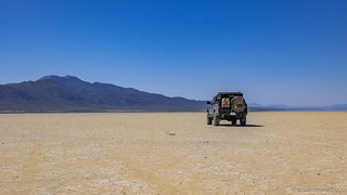
It always seems a little wrong to me to drive on a playa, but I must admit that it's a feeling like no other.
We had one final stop before town, and that was along Guru Road. This is a weird road that's been adopted by a guy named Dooby. Adopted might be the wrong word - it's more like he's painted a ton of rocks in ways that you might expect in the middle of the desert and just a few miles the site of Burning Man - and built a few shrines for various purposes. It was less than I'd expected, and it seems to change over time as well - a sculpture that @mrs.turbodb had seen a photo of and thought was interesting, wasn't there, for instance.

The Black Rock Hitching Post and Chapel.

Dooby Vision.

This blue-bellied western fence lizard was actually the highlight of Guru road, for me.
Finally, we reached Gerlach. I say "finally," but it was still only about 11:30am so we were doing just fine from a progress perspective on our day - it's just that we'd been hungry for the last hour or so, and were looking forward to the tuna sandwich fixings that @mrs.turbodb had prepped before we left home. So after topping off the Tacoma at the local fuel station, we found a nice little spot in the center of town - a shady gazebo with a picnic bench - and chowed down on sandwiches and chips as we chatted with a local resident about the surrounding area. Oh, and we admired some of the art on a nearby semi-trailer, which was quite nicely done.

Imagine.
Lunch didn't take more than twenty minutes or so - as it turned out, there were lots of gnats in town, so we didn't linger - and soon we were back in the truck and headed east. Well, almost. See, we were unexpectedly stopped on our way out of town by something we'd never predicted...


We were out in that area during Spring Break. We hit up Virginia City then up to Pyramid Lake and out through Gerlach. Didn't get to drive on the playa as it started to snow and some black clouds were heading in. Really cool area up there.
nate