It's extremely rare that we camp in the same location two nights in a row, but our second night in the Jumbo Rocks campground was - being essentially windless, and certainly snowless - so much more pleasant than the first, that it was as if we'd driven for hours and camped somewhere entirely different.
Unfortunately, that didn't mean that the tent was dry. It was still cold, so a thick layer of frost had formed on all the exterior surfaces overnight - a situation that we'd ignore as we packed up a few minutes after sunrise - requiring us to redeploy the tent before setting out on our first trail of the day - to Mastadon Peak and the ruins of the Mastadon Mine.
To get there, we'd push south - through the transition zone between the higher elevation Mojave and lower elevation Colorado deserts - along the western edge of Pinto Basin, but first we made a quick stop to check out a couple granite formations I thought @mrs.turbodb would enjoy.
One of the more popular outcroppings, there'd been so many people at this arch the last time I was here, that I'd foregone any photos whatsoever.Silhouette.I wanted this rock to be a surprise, but apparently, I was the only one who completely missed the signs with arrows to Heart Rock.
After the short walk to two rather popular destinations, we took a slightly different path back to the Tacoma, soaking in the brisk morning air as the majority of the campers in the park eeked out their last hour of sleep. I can only imagine that it was like the Joshua Tree of old - with less hustle and bustle; a more solitary experience.
Not far away, we visited the Queen of the Desert. We've seen other yonic fertility symbols on our adventures, and it is thought that they came about when natural rock formations were recognized - and sometimes enhanced - by Native Americans.
After making a few off-color jokes - how could we not? - and after @mrs.turbodb indulged in a couple of "tasty biscuits" (Duet Bites) - it was back into the cab for a forty-minute ride to our trailhead Cottonwood Spring and the southern edge of the Park.
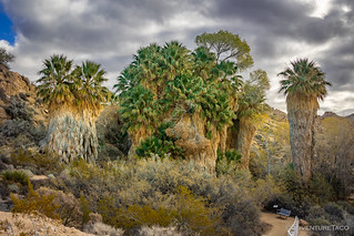
By the time we reached Cottonwood Spring, the sky was looking entirely different than it had at the northern section of the Park.Every single palm was wearing a hula skirt.Oasis.Contrast.As you can imagine, this oasis was a special spot long before the National Park existed! Several morteros decorated the granite boulders in the area.
From Cottonwood Spring, the Mastadon Loop hike would take us through a small section of the Eagle Mountains, with constantly changing terrain and commanding views of the southern portion of the park. We'd get a mix of weather as well - depending on which way we were facing - as clouds to our west and south provided a bit of drama overhead.
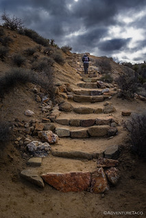
Up we go - the first of several very nice stairways.North through the Ocotillo, Pinto Mountain reached up towards the blue.Perhaps one day, we'll reach the summit.New growth on those same Ocotillo.There weren't many wildflowers, but these tiny white Eastern Mojave Buckwheat (Eriogonum fasciculatum var. polifolium) was showing off along the trail.
A little less than two miles in, the terrain changed from a gravely wash to the rocky boulders we'd experienced elsewhere in Joshua Tree, and we started our climb towards Mastadon Peak. This was my favorite part of the trail, the overcast sky tempering the usual shadows; the orange granite striking against the brilliant blue sky.
More stairs.Carving this set must have been a mountain of work.I'm sure it was caused by water over time, but I like to imagine that a bolt of lightning struck this rock, splitting it cleanly in two.
After a short, "not ADA accessible," according to @mrs.turbodb, scramble - we reached the top of Mastadon Peak. From there, views in all directions presented themselves, but none was more striking than the view to the west, where the Salton Sea stretched across the valley - a cesspool of poison.
Only a few hundred feet from the peak, the trail traversed the hillside once exploited by the Mastadon Mine. While the gold-bearing quartz vein was likely discovered in 1919, records indicate the mine was established in the 1930s and worked on and off by George Hulsey (and his family) for several decades. Originally, the ore was assayed at $744 a ton and to exploit it, an inclined shaft was eventually developed to a depth of 75 feet on the vein. However, faulting severed the main vein, and unable to relocate it, Husley eventually sold the mine, which was eventually - after the claim had lapsed in 1971 - acquired by the NPS (National Park Service).
The old shaft, well sealed.What remains of the ore bin at the mine was stabilized in 2015 by volunteers and the NPS.
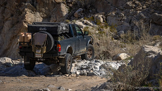
By the time we got back to the Tacoma, it was a little after 10:30am. The tent - in and out of the sun at the whim of the passing clouds - was mostly dry. After a quick towel-off by yours truly - while @mrs.turbodb prepped some sandwiches we would eat when the time was right - we got everything put away and set our sights on the first American Hiking™ trail of the trip - the road through Pinkham Canyon.
Note: American Hiking is the kind where your left foot controls speed, and your butt is remains in a seat.
On my previous trip to the Park, I'd thought that my descent through Berdoo Canyon was the only High-Clearance, 4WD road on offer, but since then I'd learned of the existence of Pinkham Canyon Road. Not only that, but the description I found led me to believe that it might be a smidge more exciting than the basically-a-forest-service-road that Berdoo turned out to be:
Pinkham Canyon is a true jeep trail with numerous ruts and rocks. A stock 4x4 with high clearance and 4 low should be able to manage the trail, but some of the sections require slow going. If you haven't aired down, now would be a good time to do so!
Overland Trail Guides
Hoping for the best but accustomed to the overdramatization of road conditions, we held off on airing down as we exited I-10 and pointed the truck north. In front of us, the Cottonwood Mountains and some rather ominous looking skies provided plenty of visual interest, even if the road seemed a little tamer than we'd been sold.
Here's to hoping for something exciting!Looks like a fun hike. Maybe for another day, when we're not American Hiking™.The wash we were climbing through was broad, with plenty of Smoke Trees lining the route.It was lots of fun to watch the sun and clouds battle against the colorful hillsides of the Cottonwood Mountains.Oh no, do you think we'll make it since we're all aired up?
At some point - around noon and knowing that we only needed to pull sandwiches out of the fridge in order to satisfy our stomachs - we stopped in the middle of the road and soaked in a few minutes of sun as we munched on the last of our provisions. Green grapes - juicy and firm - added a sweet splash at the end of the meal.
Lunch like a boss.
By this point - probably two-thirds of the way through the 19-mile route - it was blatantly obvious to both of us that this "jeep" trail was just another example of internet hype. So, while my passenger settled down for a bit of an after-lunch-nap, I did what I could to spice it up a bit.
A trail like this requires all the lights.
Soon enough we were back on only-slightly-smoother-than-Pinkham-Canyon pavement, headed north again, into the Mojave-Colorado Desert transition zone where our final hike of the trip awaited. First though, we had a stop to make - at the cholla cactus garden.
Pick one to hug.
This is a place you really don't want to bring kids, and you're asking for a world of hurt if you even think about letting an animal out of your car. These Teddybear Cholla are the devil's plant, constantly dropping cholla balls that are surely worse than the deadliest land mine, and doing their darndest to embed their tiny little barbed hooks deep into the nearest flesh.
Most of all, it is not a place where you want to heed the call of nature, should such a situation arise.
For us though, it was the trailhead for another three-and-a-half-mile hike to the Golden Bee mine. So, after gathering up our various windbreakers and camera gear, we set off towards the Hexie Mountains, our fingers crossed that the weather would hold.
Dramatic skies over Pinto Basin.After traversing a mile or so of wash, we reached the base of the Hexie Mountains.A collapsed cabin, we must be on the right track.
There are a few minor prospects scattered along this side of the Hexie Mountains, but two gold veins were discovered here that probably led to the Golden Bee: the Dickey Boy (or Dicky) and the Mabel.
By 1934, Eloge "Frenchy" Auclair and Daniel Leahy began developing the mine that would become the Golden Bee. Over the next few years, they followed the veins into the mountain with a 180-foot incline shaft, adits, crosscuts, drifts, and stopes across three different levels.
A small camp of five buildings and a headframe sprang up around the mine portal. Mine equipment consisted of a twelve-horsepower gas-driven hoist, an Ingersoll-Rand compressor, and a few air drills. The mine never had its own mill. Instead, ore was hauled over to the Wall Street Mill for processing. By 1941 and the start of WWII, the mine fell idle. Total production was about $40,000. The building at the end of the mine dump was a garage/workshop. It had the best view.
The Golden Bee Mine in 1941. Photo Courtesy of the NPS.
At some point while mining, honeybees built a hive in a water tank at the mine. They became so bothersome and aggressive that they almost forced Leahy and Auclair off the mine. The problem was so significant that the miners decided to poison the water with cyanide! That certainly did the trick and killed off all of the bees. I’m assuming they drained off the water and cleaned the tank before they re-used it. After that, the mine became known as the Golden Bee.
Climbing the hillside, we came to an old metal tank that served as the ore bin for the lowest level of the mine.An old spool of cable, once used to haul ore up the 180-foot shaft.Final ascent.The ore bin at the upper (main) level of the mine.
Reaching the top just after 3:30pm, the skies were still looking ominous and gray, but no moisture had fallen, so we decided to poke around a bit in the hopes of finding an adit we could explore. Or, more accurately, I hoped we'd find an adit that could be explored. Ultimately - unfortunately, since I'm the one telling the story - the only adits we found were sealed; understandable I suppose, since the mine is visible from Pinto Basin Road, if you know where to look. Still, there were plenty of other artifacts for us to wonder about on the upper platform.
An old slag bucket, still sitting where the slag was poured into it ... and overflowed onto the rocks below!A concrete foundation that once secured machinery of some sort - a generator, perhaps.Frenchy | Mine | Nov 30 1937The old garage/workshop. Long collapsed, but still with a killer view.
And with that, we were done. The hike back would be quick and uneventful, a little pep in our step so we could make dinner and clean up while it was still light out. Then, with no plan for where to stay, we exited the park in search of some BLM land where we could crash for the night. Anything would do, as long as we could get an early start the next morning.
The trip home...
Unlike most trips these days, this one entailed driving the Tacoma home - over the course of two days - for a bit of work that I have planned in the coming weeks. Along the way - at the northern edge of California and the southern end of the Cascade Range - we couldn't help but admire the snow-capped peaks that rose around us. While the snow pack was surely less than it'd been the previous winter, it was still a sight to behold.
Castle Crags.Mt. Shasta.Black Butte with a white cap.


Thanks Dan for the desert fix. Nice to see that there's so much wild country still there.