
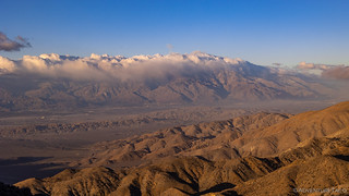
Uncomfortably hunkered down in the passenger seat of the Tacoma with a towel covering my legs for warmth, I spent the first few hours of the night transferring photos to my computer and doing a bit of reading. By 9:00pm, winds were strong enough that waves of sand where being thrown against the side of the truck as it rocked relentlessly with each 60mph gust. It wasn't until nearly midnight - after falling asleep for a few hours - that I decided I really ought to point the nose into the wind.
...HIGH WIND WARNING REMAINS IN EFFECT FROM 4 PM THIS AFTERNOON TO 4 PM PST WEDNESDAY...

* WHAT...West winds 40 to 50 mph with gusts up to 65 to 75 mph expected.

* WHERE...Western portion of Joshua Tree National Park, Eastern portion of Joshua Tree National Park, Chiriaco Summit, Palo Verde Valley and Chuckwalla Valley.

* WHEN...From 4 PM this afternoon to 4 PM PST Wednesday.

* IMPACTS...Damaging winds will blow down trees and power lines. Widespread power outages are expected. Travel will be difficult, especially for high profile vehicles. Widespread blowing dust will be possible, leading to reduced visibility.
Fun times.
Not wanting to open the doors - having experienced these types of winds and bending the driver side door hinges at Mt. Patterson - I crawled over the center console and rotated the truck into position before resuming my restless endurance of the relentless weather.
By 2:00am, windspeeds had increased significantly and the intermittent sandstorm became continuous - or at least, I thought it was sand. Not until daybreak did I realize that the sound I'd heard pelting the cab was snow - the entire ground covered in a thin layer of the white stuff.
No wonder I'd gotten so dang cold!

Unlike my previous days, I had only two items on the agenda for my last full day in the park. First, I planned to drive Berdoo Canyon - a road that I've heard about several times in the context of Joshua Tree as being a must drive for any 4x4 enthusiast. Then, I was headed to the southern edge of the park for a eight-mile hike high into the Eagle Mountains - to Cary's Castle.
And so, freezing cold and eager to get the heater turned on in the Tacoma, I pulled out of camp a few minutes after 6:00am - well before sunrise - and headed south towards the Geology Loop Road and Berdoo Canyon. Almost immediately - passing a turnoff to Keys View - I got sidetracked, figuring that I might as well check it out if I was here!

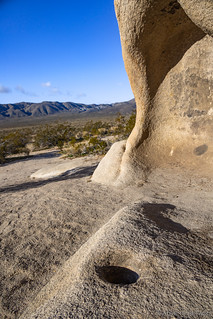
An hour later I was back on track, bumping along one of the few dirt roads in Joshua Tree, making my way towards the southern border of the park. It was still windy, but thankfully the worst of it seemed to have blown through, and when I arrived at Squaw Tank, I decided to get out and check it out while I munched on a few handfuls of trail mix.

For more than 1000 years, members of the Serrano tribe of nomadic Native American Indians inhabited this area, using Squaw Tank as a camp site where water could easily be gathered at different times of year. Numerous natural rock shelters dot the landscape, many of them with evidence their previous inhabitants.

By 8:15am, I was entering Berdoo Canyon, a sign warning me that there was no cell signal - something I'd not had anywhere in the park - and that people have died on these back roads, so I'd better be careful.
That sounded good to me, and I pushed on, figuring that the 15 mile trail would take a couple hours to complete. That would put me into Indio, CA - where I could pick up a bit of fuel and stop at In-n-Out - for an early lunch, before searching for the treasure that is Cary's Castle.

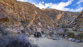
Ultimately, Berdoo Canyon wasn't all that interesting - to me at least. The road was easy - nothing the right line in a Subaru couldn't accomplish - and for the most part, the views were only so-so. I suppose that for folks trying to get into Joshua Tree from the southwest, or for those who haven't done much off-road exploration, this could be a nice way to enter the park - but it sort of reminded me of Funnel Lake in Coyote Flat - popular for no particular reason except that showed up on YouTube and then everyone jumped on the bandwagon.


Part way down the canyon, my check engine light came on. I've gotten used to this over the last couple of years - the culprit seemingly always the same: a P0420 code thrown by a catalytic converter that's eventually going to need to be replaced - so I didn't really worry about it as I fired up my OBDII reader to check and clear the code.
This time though, the code was different. A P0120, it was apparently a Throttle/Pedal Position Sensor “A” Circuit Malfunction. The throttle seemed to be working fine - I hadn't noticed any revving or slow throttle response - so I cleared the code and waited to see if it'd come back. Less than 30 seconds later, it did.
Awesome.
There wasn't much I could do until I got out of the canyon and to cell service, so I wrapped up the final few miles and made my way into town. Berdoo Canyon - in all its glory - had soaked up a whopping 41 minutes of my time. It was 9:01am, which meant I had two hours to kill until I could grab a couple burgers at In-n-Out.
After filling up on fuel, I pulled into the In-n-Out parking lot and was happy to see that employees were already showing up to work. Now with a little more than an hour to wait - while they warmed up the grills and got to cutting potatoes - I figured I might as well do a little research on the P0120 code while I aired up my tires.
Turns out that this code can be an indication of the Throttle Position Sensor (TPS) - the thing that tells the computer how much gas you're giving the vehicle - is going out, but it can also indicate a problem with the air intake system. In that case, the computer expects a certain amount of air to be measured at the MAF and through the throttle body, but instead it sees a different amount.
The easiest way to determine the actual culprit is to check the real-time readings from the TPS, and if those readings - as you slowly depress the gas pedal - move smoothly through the range of values - then the culprit is likely the air intake system, and a good cleaning of the MAF and throttle body can often resolve the problem.
Well, that sounded promising, and I made a quick run over to AutoZone to pick up some cleaner for the MAF and throttle body. I'd end up using these in camp later in the evening, and I haven't seen the code since!
By 11:15am, my belly was full, the Tacoma was topped off, and I was on my way.

I wasn't on the freeway long before my exit presented itself and I headed for the hills, literally. My destination wasn't far - only a few miles of well-graded road - as the hike began at the Joshua Tree National Park boundary; no vehicles are allowed in the wilderness. I found a nice spot to park and got myself ready for a trek.


With my destination some four miles - and 1,250 vertical feet - away, I wondered how far into the Eagle Mountains I'd get before I found Cary's Castle. In fact - while not at the highest point - I'd be along the ridgeline, affording me views in all directions. I'll get to that in due time - for now, it was time to look around and enjoy the "roses." The wash - and then canyon - were full of spring!


Arizona Lupine (Lupinus arizonicus). (right)


Of course, besides spring, there was plenty of rockery around to indulge in as well. It was a good thing too - my feet sinking into the soft sand and making every step more difficult - because hiking up the sandy wash was quite the workout. The views allowed me to stop regularly for photos, since I definitely wasn't tired every few hundred yards. Nope, definitely not.


Winding my way up the wash, at some point I realized that at each questionable point in the trail - where I wasn't sure if I should follow a route to the right or left - some idiot had spray painted the rocks with big dots and arrows to indicate the way. Seriously, what are people thinking?


Near Cary's Castle sits the Welcome Stranger Mine, I figured I'd save the best for last, and headed over to check the mine out before searching for what I knew would be the highlight of the hike.
Arthur L. Cary - only in his early twenties at the time - was involved in the filing of four claims east of Eagle Peak between 1938 and 1940. The “Beacon #7," "Beacon #8,” “Welcome Stranger,” and “Duffie No. 1" were jointly filed with his father-in-law and other members of the Grisham family.
The Welcome Stranger Claim, which today is generally called “Cary’s mine” was located on November 12, 1938. Cary was the sole locator of this mine, which he estimated to be “…about 4.75 miles in an E/S direction from… the summit of Eagle Mountain”. Apparently, Cary wasn’t too good estimating distances - he overestimated by nearly 1.75 miles.Tom Mahood


Retracing my steps, I rounded a corner to find my second house-build-into-boulders of this trip (the first being the cabin at the Eagle Cliff Mine a few days earlier). I have to admit - I was at least as excited this second time!


Cary was born in Bogue, Kansas on July 18, 1914, to a farming family. By the time he was five, he and his family had moved to Colorado, a bit west of Lamar, eventually settling in Granada, Colorado where he went to high school and met his future wife Eleanor Fern Grisham.
By 1935 Cary had moved to the Coachella Valley in California, residing in El Centro, and by 1940 he was living just north of Holtville, still in the Coachella Valley. During this period, he and his wife had a son, Harold D. Cary, born November 5, 1939.
The 1940 census records show Cary, his wife Eleanor, and their son, all living with Elenor's parents - Tom and Ollie Grisham. Cary was employed as a vegetable truck driver making $1,820 annually (about $40,000 in 2023 dollars) and his father-in-law was employed as a ranch foreman but - as we’ll soon see - it appears the whole Cary/Grisham family had an interest in mining.
Voter registration records indicate Cary lived in Holtville for many years, at least until the 1960s, working as a mechanic and tractor operator. Oh, and he and his wife were Democrats for those who keep track of such things. Eventually he relocated to Nevada, near Las Vegas, and died April 8, 1976, in Henderson.Tom Mahood


Delighted to have found the cabin, and after exploring around a bit more - which I highly recommend as there is more to find  - I was ready to head back. A bit after 2:30pm, I had plenty of time to get down the mountain, so I was in no rush as I retraced my steps.


I made it back to the Tacoma a little after 4:00pm and - for the first time all trip - I took it easy. Not knowing what the camp situation would be like at the location of my final hike the next morning, I decided that my perch - overlooking the Chuckwalla Valley - was the perfect spot to spend the night.
For a while, I hung out in warmth of the cab, watching in the distance as traffic moved east and west along I-10. Eventually, I remembered - something that's harder and harder these days - that I had some cleaning of my air intake that needed taking care of, so I did that. And finally, a little before sunset, I made my final dinner of the trip and deployed the tent.

As I'd suspected it would be, the hike to Cary's Castle had been one of my most enjoyable of the trip. In one of the most remote areas of Joshua Tree, its remoteness was part of what kept it so special. And, if that was any indication of my final hike the following morning - things were certainly going to get interesting!


Another very interesting posting and photos. You have inadvertently convinced me to invest in an OBD ll type scanner, as my trips are also to remote areas, and solo. Which brand OBD scanning tool do you own and would you recommend it? Does it have all the essential features you would need for remote travel? Thanks.
Hi Lapsley, I have a Kiwi3 scanner. It's not the cheapest of the scanners out there (it's in the $100 range, and you can get them in the $20 range), but I really like it for a couple reasons: first, it works with both Android and iOS via bluetooth, and I have both types of devices. Second, it uses very little power when the vehicle is off, so it doesn't drain the battery if I inadvertently leave it plugged in.
Blowing sand, high winds, welcome to the desert! For the past few months winds have been worse than usual and I find myself shoveling out the driveway frequently. The sand/dust is so fine out here that it will blow around/through everything and the cab of my truck will attest! As for code readers, handy little items, saved me some trips to the mechanic and helped me decide what is serious and what is not. Thanks for sharing a dandy trip to Joshua Tree, maybe we'll get over there one day but I think we'll be doing Anza-Borrego first. Always enjoy your reports and all the great photos, Thanks again!
Oh man, I do know about the winds! There have been a couple times where it's been "really bad," including this one where we ended up taking everything out of the tent in order to clean all the sand out in the morning, but I've never had 75mph and sub-freezing temps. It was brutal.
Glad you're enjoying the Joshua Tree story; I'm in the process of sending out emails for the last part of the story, so you've either got it in your inbox or will have it soon (and of course, you can always just go read it ?).
I hate the wind. Colorado has been experiencing fire weather. I'd never heard of it before this year. It has to do with the wind and dry conditions. The state has been informed we're heading into drought conditions again. It's every year and hasn't changed since the 1950s. And we'll get hurricane level 1 sustained winds. Our tornadoes are pretty strange, too.
An OBD sounds like a good thing to have, but the only time I've needed one was when an oxygen sensor went out in my Explorer. That's not to say one wouldn't come in handy in the future, and they're not that expensive. I've traveled solo since 2013, so the extra insurance wouldn't be a bad idea, except for when I'm out in the middle of nowhere. Then what, I'm not a mechanic and I don't know how serious the code means.
One place in Joshua tree that's silly with Chia plants is in the BLM overflow camping spot I was telling you about. I've wondered if I could grow them in Colorado but it would be as annuals.
Those chollas are evil. I've heard some people call them the porcupine of the desert in that they will throw their spines at you - urban myth. But their spines are like porcupine's, loosely attached.
It bears repeating I love your trips, the photographs, the occasional silliness. I know some of those roads I would never attempt, although I may think about it. So I get to see what they look like and some of your descriptions and think, nope I'll let you drive them.
Hi Darlene, Always nice to get your comments and thoughts. Came back to this one after a few days down in SE Utah where I was exploring around for ruins and rock art - a fabulous time with fantastic weather!
Bummer to hear about the CO drought. I guess I assumed (incorrectly, which I guess is what you get for assuming) that CO would be getting a ton of moisture like CA, OR, WA, ID, MT, WY, and UT. In fact, I ran into a couple BLM employees on my recent Utah trip and we were talking about how wet everything was - there's water in a bunch of the canyons - flowing no less - where the canyon bottoms are usually completely dry this time of year!
Honestly, for the OBD scanner, I'd probably only get one for two reasons (a) if you're going to try fixing things at home, and need to know what to fix - or at least, where to start. (b) if you want to reset the codes - and turn off the check engine light - when you're out on a trip. Otherwise, I think that for most people, they aren't all that useful, b/c the codes are so cryptic. 99% of the time, I find myself asking a more knowledgeable buddy, or searching the internet for whatever the code is, b/c I have no idea myself!
And of course, knowing that a check engine light that is solid is (usually) not a big deal, but that a light that is flashing means "stop right now and get it looked at," is the most useful thing to know about the check engine light.
Hope you continue to enjoy the stories and silliness! ?
I'm glad the check engine on the Explorer was nothing more than one or more oxygen sensors. The mechanic replaced all of them. Silly light came on again half an hour later and back we went. No more trouble for the next few years. I miss that old green machine. Even though it was as AWD, it took me where I told it to. It appreciated the moderate routes.
Drought is a funny thing. We've had great snows this winter, but it's never a sure thing. There are "SNOTEL"s set up by the state and USDA all over the mountains to monitor snow pack and to measure for equivalent snow water. The mountains and higher elevations are still getting buckets of snow. The eastern plains and the western part of the state are hurting for moisture. We have a lot of dry land farming and winter wheat. The state actually manages to be drought free in the winter for about a week. It's too bad we can't have that in the summer.
There are only two states in the union that does not get its water from outside the state. One is obvious, but you'd think Colorado would get its share of water from rivers. Nope, 100% is the form of snow and rain. Answer at the end of my comments. There was one winter that we hardly got any snow. Lake Powell practically dried of but the Colorado River Basin does have tributaries to help feed it. It's just not enough. Then there's the spring flooding. It will start any day now. The high mountains will keep its snow a while longer, but the lower elevations gets rain that will then melt the snow. There's one major river that flows through Denver and it flooded big time in 1965. We were living in the mountains, I got bit pretty good by one of our cats, and there was no way we could get to the doctor's office. Good thing for that wonderful invention called the telephone.
I live in Greeley, 50 miles north of Denver. We've had two major floods through here, 1976 and the other in 2013. There are three major rivers that feed the South Platte and the four converge to wipe out the lowlands. The South Platte flooded clear to the northeastern corner of the state and beyond.
Every western state (well maybe not Washington - giggle) has been affected by drought. Wyoming is not immune and neither are the other states you mentioned. Utah, Nevada, Arizona, New Mexico are dry as a bone when I go through. Just wait, Utah canyons will dry up. A lot of water is taken out of aquifers when there's not enough rain or snow. We have irrigation ditches that criss-cross all across the state and where do they get their water from? You got it.
Isn't everything wet in the winter? One summer I camped for two nights at Chaco. It rained each night. Last year it rained two different times on the same day in Utah. We're talking about July. That's why I call the weather bipolar.
The powers that be made a lot of mistakes when they drew up water laws and made contracts with the states in the Colorado River Basin in the 1880s. Even Tuscon gets Colorado water. Cities are growing too fast, no one economizes the use of water, right people just laws. Farmers insist on growing the biggest water guzzlers in the country: alfalfa, pecans, almonds, soybeans (who knew), rice. Until recently Colorado citizens was not allowed, by law, to collect rain in rain barrels. Unbelievably, the idea was even though the rain fell on your roof first, it then fell on the ground and then flowed downstream to someone else's property, meaning you're taking, I say stealing, water from them. We can now collect a whole two barrels or 110 gallons but it has to rain first.
We seem to get tons of moisture all at once.
Thanks for letting me go on, and on, and on. So much to share.
Go on and on all you want, I always love getting comments like this. The color they add, and the opportunity to think about these things are one of my favorite parts of the blog!
Water is such a complicated situation in the US (and maybe the world, I suppose). I'm right there with you on the water laws being all messed up ("use it or lose it") and at some point it's going to be too late - because as you mention, the aquifers are drying up. Those have been the real savior through the years of drought in the west, in a way that most people don't realize. But when one used to have to drill to 50' for water, and now has to drill to 500' or even 5,000', there's a real problem that a season or two of rain won't solve.
And of course, having grown up in CA, I've seen my fair share of terrible water use. The central valley routinely floods the fields (though, in the last few years it's gotten a *little* better) for irrigation and people are forced to *buy* drinking water b/c the groundwater is polluted. Not to mention the aqueducts - shipping water - uncovered all the way through the state (and from other states) under the hot summer sun, "taken" from where it fell, and evaporating all the way.
I sometimes wonder if the next "gold rush" will be for clean water. It will be unless/until we figure out how to do desalinization at reasonable prices.
Can you share way points
Hi John, it's always a balancing act to figure out how much detail to give about locations in my stories. You can read more about my approach in this post: Do you have a GPX for that?
I don't do way points, although I do have a Garmin GPX. One year my husband made me get a personal locator beacon. He was afraid I would get lost in Death Valley. I've never used it, but you never know. It's in my backpack. I rely a lot on maps, maybe a compass from time to time if I can't tell where north is. My trips are planned to the point of obsession, with a disclosure that it's subject to change at any moment.