
We awoke as we usually did, just before the sun spilled over our camp - the beginning of our last day on the trail.

It would also be the day that we ran two of the most beautiful trails we'd encounter over the course of the entire trip. And - to tilt the scale in the favor of good, as far as the day was concerned - it was the second time we'd make a group breakfast on the trip - a last-day-tradition that I hope continues forever.

We each easily ate over a pound of breakfast. Bacon alone was a half-pound serving per person!
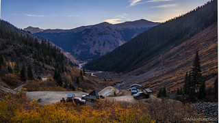
Unlike the last time we'd had a big breakfast and then gotten out of camp just before noon - this go around we were a little more attentive to the time given our plans for the day. It was only a little after 10:00am when we rolled out of camp, and covered a couple of twisty miles of pavement before pulling off at the start of Black Bear Pass.


I understood almost immediately why Mike @Digiratus had requested that save this trail for our last day. And we hadn't even gotten to the dramatic part - I was told.


As with several other passes we'd crossed, Black Bear Pass has a plateau in the trail, not long before reaching the top. We stopped here and I pulled up next to Mike - probably ruining his photo (sorry Mike) - to let thank him for making this one of our final trails.

And with that, we pushed to the top.

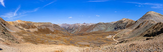
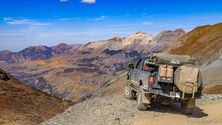
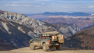
At 12,840 feet, Black Bear Pass wasn't our highest elevation - but that doesn't mean it wasn't one of the most dramatic. Views unfolded in every direction, and the smoke that'd been with us through much of the trip seemed just a little fainter on this special day - the color of the distant ridges, vibrant in the morning sun.


I didn't say anything, but I was surprised at how fast we'd reached the top - and how easy it'd been. I'm glad I didn't, because it would have shown how ignorant I really was about the trail system in which we found ourselves on this glorious day. Not a bad thing I guess - being pleasantly surprised by what you find on the trail - but unusual for me, at least to this degree!
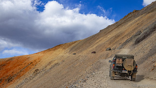
With a couple of Geo Trackers and a Jeep coming up the trail behind us, we didn't linger for too long at the pass before heading down the north side.


Like the front half of the trail, the first section of the back half seemed to alternate between segments of shelf road and open plateau. Naturally, the views from the shelf were spectacular and being that it was my first time experiencing them, I found my myself in catch-up mode as the crew was turning out of the mountains and onto the upper plateau.
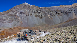
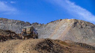
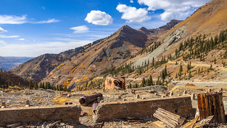
Making our way through the plateau, the driving still wasn't overly technical, though there were a few ledges to step down, and flexy places to pose, as we continued along the trail. Old mining equipment reminded us why these roads were here in the first place.


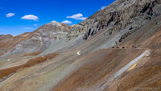
And then, as we neared the front of the plateau, the ground seemed to suddenly fall away, Telluride visible far below. Apparently the secret of Black Bear Pass was that the beginning was deceptive, and we still had a ways to go! 


This - I realized as we made our way through the steps - was what gave this trail its reputation. Not overly difficult for the experienced driver, but daunting for some, given reasonably narrow roads, steep drop-offs, and rocky terrain over which we drove.


The biggest problem for me was that I wanted to keep stopping - there was so much to see on the way down. While the rest of the guys made quick work of the steps - easily following each other's lines and able to keep an eye on each other - I found the gap between us widening as I paused to snap a photo of an old tram tower hanging on the side of the cliff!


Not all the tram tower remained poised high above Telluride, much of it had succumb to the harsh winters and time.
And with that, we'd completed the most mentally taxing section of trail, and reached the final set of switchbacks that would deliver us to Telluride. I should note that looking back at this portion of trail after completing it - on our way out of town and towards Imogene Pass, it doesn't appear that a road should be possible on this little piece of earth - a piece that appears completely vertical.
And yet, the switchbacks are visible, and we were on them.

Like many old mining roads, one from our day and age may wonder, "How does a road exist here?"


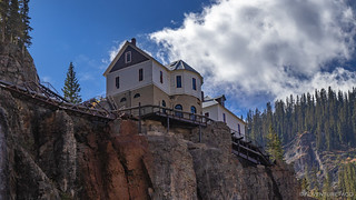
As we ticked off one switchback after another, our view of the Bridal Veil Power Station got better and better. Officially the Smuggler-Union Hydroelectric Plant, it not only generates 25% of the power used in Telluride, but has also served as a residence over the years. Originally built in 1907, it was restored in 1988 by a local resident, who later gave up his lease to the Idarado Mining Company that owns the land. (wikipedia)

Soon, all 12 switchbacks were behind us, and we were back in civilization - traffic in Telluride thick with tourists, the mask wearing during this crazy time ...minimal.
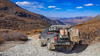
We stuck around only long enough to get gas for the trucks - or a couple of them anyway, since some of us don't run superchargers - and then we were headed back towards town, where our trail up Imogene Pass would begin.
Is the gas station out of town, just so that folks are subjected to this view as they return?
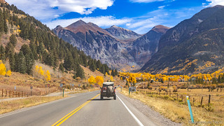
It was just after 2:00pm when we began our ascent - all of us hungry and on the lookout for a nice place to stop and eat lunch. We'd be a little late - sure - but what would anyone expect after the feast we'd had for breakfast?

Imogene dazzled almost immediately, the sheer walls full of color, and the trail winding its way through the mountain!


Running essentially parallel to Black Bear Pass - simply one canyon over - views opened up as we neared the tree line, our path leading up into the clouds, all there in front of us. As the final trail of our two week adventure, this was quite clearly a cherry on top of an amazing trip.
It was here that we found the perfect place for lunch - a pull-out on the side of the trail, with space for our trucks and old tram towers to boot! We made sandwiches and snacks, grabbed our water bottles, and explored the ruins with our eyes.

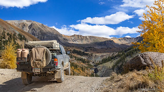
The towers it turned out were just the tip of the spear for the Tomboy Mine - the largest mining complex we'd seen all trip - just a little further up the road and sitting at 11,509 feet. As we wrapped lunch and made our way higher, the scale of the mine - spreading across the landscape - was remarkable.


The Tomboy mine and Savage Basin Camp was located 3,000 feet above Telluride. The settlement contained a school, store, stable, and the miner's cabins. The Tomboy started producing quantities of gold ore in 1894 and in 1897 the mine was sold for 2 million dollars. A daily stage ran across this shelf road carrying passengers and mail.
One of the top three producers in the region, upwards of 1,000 workers were employed at the mine, which had many amenities for its employees. These included a YMCA, bowling alley, and tennis courts. A club that held dances - "free for all ladies desiring to go to the dance." Still, like other mines of the day, the Tomboy saw its share of violence - several men shot over various disputes - before closing in 1927 when the gold and silver ran out. Over its 47 years of operation, it produced millions of dollars of gold, silver, copper, lead and zinc.

The Tomboy in the late 1800's.
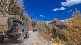
From the Tomboy, the trail began its final ascent to Imogene Pass. Once again on narrow shelf roads, we checked - and waited - for oncoming traffic before proceeding up the switchbacks. For me at least, the pause only added to the suspense of the moment, the reputation of this pass having been in the back of my mind for the previous two weeks.

And then, we arrived.

The view from the pass was stunning. Perhaps not the same dramatic view we had from Hurricane Peak or as we came down into Telluride over Black Bear Pass - but stunning nonetheless as we looked out over vast distances and an innumerable number of San Juan and Rocky Mountains.


In addition to views, a mailbox - one that's seen better days - decorated the ridge. Covered in #EAF, #instafabulous, #overland stickers, I found it funny that a Microsoft sticker was front and center. Oh, how life plays tricks on us in funny ways. 

It was windy at the top - for the first time on the trip, there were clouds in the sky - and we each donned an extra layer of clothing to keep ourselves warm as we continued to snap photos and watch traffic as it climbed, summited, and descended. Most interesting was a Jeep Gladiator JT. Completely wrapped in vinyl to make it seem like it was rusting, its owner had decked out all four sides with bright white LEDs - camp lights, really. Distracting - as you couldn't tell if was approaching or departing - and questionably legal, I wish I'd thought to snap a photo to capture the odd vehicle, if only to share its oddity.
Instead, we each focused on capturing our vehicles one last time before starting down - this, the final descent of our trip!

We only made it about two-tenths of a mile - to a nearby overlook - before climbing out of the trucks again, this time with a final view of Corkscrew Gulch and Red Mountain No. 1, still gleaming bright in the semi-cloudy conditions.


Also from this same vantage point we spotted an old mining structure, perched on the side of a lake, beckoning us to explore. Unfortunately, the road was gated and the distance too great given the time, so a photo and note to return in the future were all we could afford on this trip.

And with that, we were off - starting our descent for real, on the lookout for somewhere to camp. Preferably with a view, though none of us were likely to be picky on this, our last night.

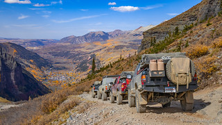
All lined up and ready to go.
Couldn't resist one last overlook shot as the road curved around an outside bend.
In the end, we made it all the way down Imogene Pass Road without finding a spot. This probably should have been surprising - the traffic here is likely insane during the summer months, and camping along the trail would surely destroy the area. Still, as we skirted the Camp Bird Mine, we were all wondering what our next step would be.


We extended the trail - if only slightly - by following a powerline road a mile or so west, its exit to Camp Bird Road near the entrance to Yankee Boy Basin gated by a large granite slab. This bit of fun was the last real "4-wheeling" we'd have on this trip and we all enjoyed taking various steep, off-camber lines up its face.

Ultimately - after searching a bit in Yankee Boy Basin and a couple of the surrounding roads for half an hour - we decided to make a beeline to civilization, the smoothly graded road allowing us to travel quickly to a spot just a few miles from our entrance to the Alpine Loop a few days earlier.


There, we aired up and discussed our plan - to head north from Ouray towards Grand Junction - the Accuterra maps I had as part of Backcountry Navigator XE showing plenty of BLM about 45 minutes away.

We drove through sunset, twilight, and into the dark. By the time we reached BLM land and found a flat spot to camp - just a few miles north of Delta, Colorado - everyone was ready to call it a day; mostly.
You see, as we'd driven our way into the dark, I'd realized that if I left for home now, the 20 hour drive would put me home sometime in the late afternoon Saturday, rather than early in the morning Sunday. I'd be tired either way, but by arriving on Saturday I could get a good night sleep and still have Sunday to get the truck put away.
So, with understandable ribbing from the guys, that's what I set off to do. It was a good decision, really, since it put me through Salt Lake City just after midnight, the traffic lighter than its ever been. The only downside: I missed the last night of guac and some time around the fire - but hey, that just left me hungry for the next time we all get together!
Thanks for the great trip Monte, Devin, Mike, Dan, Mark, Emily, Steve and Megan - I hope you enjoyed it as much as I did!


Another Great trip report! I live here and your adding trails to my list.
Glad you enjoyed it Steve! Lot's more trips you might like under the "Trip Reports" link at the top of every page 😉 ?
Man, did I ever!! This pushed Colorado to top of my must see!! I hope the damn border opens this year!!
Mike, aka @project_pos_taco
I'm sure you could find some remote crossing that just happened to be passable on 37" tires on a badass 1st gen. Not that I condone such lawlessness. 😉
Another spectacular trip and journey! Thanks for sharing your adventures with us, the best photos of the entire trip. My trips similar to this is but a memory and a chapter in my book of life.
My travels in Idaho and Oregon desert and mountains help me to recall some of my best trips and the great folks I have met.
Thanks again!
Kenny
ps, when will your next trip be? do you do more than one trip a year?
Thanks Kenny! When the next trip is, sort of depends on what you mean by that. With the whole group, the next trip will likely be sometime in late spring next year.
For @mrs.turbodb and I, the next trip is already in the books, as it turns out - two in fact. Both to Death Valley, and both a great time. I've just been holding off on posting them until this Colorado trip is done.
I'll probably post them starting just after Christmas, but you can get a sneak peak of where we went here: AventureTaco Trip Index (for 2020).
Another great trip and report! Mush of the beginning of your trip was new ground to me, but I've spent lots of summers in the Ouray area. It is hard to not go back to that place.
Thanks Keith - I'm sure I'll find myself back in Colorado in the coming years - such beautiful country. I'd like to run the Colorado BDR - I was originally planning to run NM next year, but now I can't decide between NM/CO - and I'd really like to spend 7-10 days in the Alpine Loop area; taking it slow and trying to see as much as possible.
I just have to keep remembering that (a) I don't need to do it all by the end of next year, even though I want to, and (b) there's so much to see that I'll never see everything! ?
Wow, just adding my awestruck-ness.
All so beautiful and inspiring.
Love the views.
I keep wondering about that big house built into the rock - with all the equipment needed? And how long would it take to get to a store?!?
I have checked out the entirety of your 13 posts of the Alpine Loop as you suggested. I went late August 2021, starting in Lake City and did the part of the loop to Animas Forks, Eureka, and Silverton. The trip was short lived. A lot of things on that route I didn't see, but don't you know you have to leave something for the next trip. So I did the northern passes, next time will be the southern part, more sightseeing along the road to Silverton, and there's a lot of places in the Creede area.
I'm curious about that Mineral Creek Road you went on. I believe it's called Mineral Creek Trail, very narrow and very rocky. I went down it with a friend, I'm glad I didn't try it if it's the same one you mentioned. The lower half would have had me walking if I was driving. In fact when I was there, a greenhorn got spooked and his passenger did walk down to Hwy 550.
I have to ask. Did you see the Thoreau Cabin on Engineer? I've seen photos and there used to be a USFS sign designation. It was gone when I was there. I took lots of pictures.
I come from a photographic family back to my great grandfather. My grandfather owned two photo studios, one in Ouray and one in Montrose. With the advent of the digital camera, I have the luxury of taking hundreds more photos without the expense.
Reading this series takes me back through the years. My grandfather homesteaded south of Montrose, my dad was born there. My grandmother taught school although it was against the law for a married woman to teach school in Colorado. The laws at that time were extremely restrictive for women.
I've been over Imogene, gorgeous scenery. I have plans to go to Tomboy from the Telluride side. Not as heart stopping. I haven't decided about Black Bear. Ophir is moderate. You didn't mention it, but you have to been to the trailhead of Mt. Sneffels My dad took us once and the meadows were just thick with Columbines. And there are mountain road/passes from Durango to Telluride.
I've subscribed to your blog and it's fun to get all your trips. We like to go to the same places and do the same things. I didn't think I'd ever find who did that. Keep up the good work.
Anyway, I'll be back.
Darlene - so glad you've enjoyed the stories, and to make it through all of them... kudos! ?
I feel like the loop - as you mention - is a place where there's always going to be reasons to go back. Be those "unseen" places or places that just have to be seen again because they were so beautiful, or because they are so different with the seasons - I can't imagine that I'll ever stop wanting to return!
I've been on Mineral Creek Road a couple time (so far). The first time (2020) we were headed up the lower section from 550, and the last (2021) was coming down the entire trail in the rain (on our way home) after completing the New Mexico Backcountry Discovery Route. Personally, I thought that the upper section was much more difficult; the bottom section is rocky but didn't seem to have quite as many "bad consequences" as the top. At least, in the rain!
I did not - as far as I recall - see the Thoreau Cabin on Engineer Pass. Sounds like that's just one more thing I'll have to put on the list for when I go back. The trailhead to Mt. Sneffels is another reason - I'll need to look up where that is, because I've not heard of it (though you mention I was there, hahaha). Oh, and Animas Forks - every time I've been through, it's been raining or we've been in too much of a rush to really look around. I'd love to poke around there for a few hours, checking out all the buildings, the mining structures, etc. Of course, I won't be drinking any of the water, as pretty as it looks as it poisons it's way down the creeks.
Loved getting your comments - these stories that others have are always so enjoyable for me. Please continue to share them whenever you can, or whenever one of my stories jogs a memory for you!