

Stage 3 of the New Mexico Backcountry Discovery Route - Truth or Consequences to Reserve.
As we made our way through T-or-C, a huge mural of Geronimo caught our attention. Given that we were - essentially - travelling through Apache lands for much of this adventure, it seemed only appropriate to wait a few minutes for the rain to stop in order to capture the moment.

Geronimo, of the Bedonkohe Apache tribe, and the last to surrender to the US Army in 1886.
Whereas the first stage of the BDR had taken us a little over a day, the second had taken significantly less time, and it was mid-afternoon as we headed north out of T-or-C, towards the ghost town of Chloride and a canyon I'd heard good things about: Chloride Canyon.
Luckily, the rain had stopped and the dry desert had soaked up every last bit - the roads dry and dusty, as though it'd never happened.

The roads were once again, nearly gravel highways.
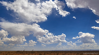
The clouds were looking fine after the rain.

North, in the distance, the Black Mountains.
As had been the case earlier in the day when we'd taken a well-graded dirt road that essentially paralleled the highway along the northern border of the White Sands Missile Range, we did the same thing on our way to Chloride Ghost Town - rejoining NM-52 a few miles from Winston.

Approaching Chucillo Mountain, Winston, and ultimately the Gila National Forest.
What would eventually become the town of Chloride - more appropriately called an old town now, rather than ghost town, as there are people and businesses still doing well here - was founded by Harry Pye in 1881, A muleskinner by trade, Pye had dreams of being a successful prospector when he discovered a rich deposit of silver along Mineral Creek as he hauled supplies from Hillsboro to the army encampment at Ojo Caliente. He kept it a secret as he fulfilled his military contract and returned in 1881 to file a claim. As word of the discovery spread, miner, prospectors, and those who prospered from their success flooded the area in spite of the infringement on Apache lands and subsequent reprisals. Pye was eventually killed by the Apaches during one of the many skirmishes. (Ghost Towns of the Southwest)
Several of the original old buildings still stand, including the Pioneer Store Museum, which is worth reading about if you're a fan of history.

There is not an info board that goes unread on our trips. The few minutes it takes to read them are well worth the time.

The Doodle Dum Cabin. Built in 1921 by Mr. Austin Crawford, it was constructed of stone and steeply pitched roofs to protect its inhabitants from large hailstones which Crawford believed would one day rain down in a display of God's wrath.
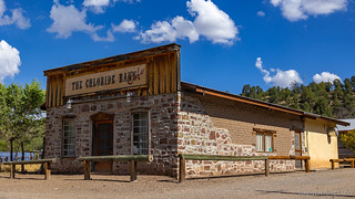
The old bank. Now, a tasty cafe... though like every other food stuffs outfit we tried to sample - closed when we arrived.

Grafton Cabin and an old bulldozer.

I sometimes wish that the colorful logos of the past were carried forward by their brands. This is so much more fun than CAT.

Craftsmanship for the ages.
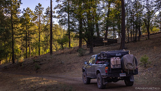
Having spent a bit more time in Chloride than I think we'd planned, the route turned up one of the old driveways and just kept going into the canyon behind town. We smiled as we realized that we'd finally be on - for perhaps the 2nd or 3rd time this trip - something that wasn't regularly graded!

Into Chloride Canyon. This road was considered "expert," and a bypass was provided by the BDR team. You know, in case you were on a Goldwing or something.
Three miles into the canyon, it only took a simple glance around for us to realize that there'd been a mine here. I'm not sure we could have done the same thing five years ago, but having explored our fair share of tailings piles and old mine roads in that time, it didn't take long for us to find a couple of the old shafts, as well as a cabin perched above the wash.

A remnant of the Nana mine.

Hand hewn.
While we probably could have spent another hour checking out the ruins here, it was 5:30pm - and that meant two things: first, it was pretty much the hottest part of the day; second, we needed to keep moving so we could - hopefully - find camp at a bit higher elevation. And so, we retreated to the air conditioned cab of the Tacoma and pushed on.

Westward bound, into the heat of the sun.

The canyon started out rather dull...

But soon, there were rocky cliffs rising all around...

And some narrow spots that would have provided the perfect place for an ambush back in the pioneer days.
It was in one of these narrow sections that I spotted some pictographs on one of the walls. In fact, I'd just been commenting that this seemed like exactly the type of place where we should expect to find some sort of rock art and dwellings - again, an indication that even I learn what to look for when shown enough examples over the years! 
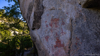
Bird tracks and cubed snowman, in red.

Basket weave and more bird tracks in the soot on the ceiling.

Keeping our eyes peeled.

59 ticks.
The remainder of the canyon was a fantastic drive - the scenery and geology captivating, and the road rough enough to require a bit of actual attention. We enjoyed it thoroughly as the miles ticked away, and we eventually climbed up and out of the canyon and began our ascent into the higher elevations of the Gila National Forest.
It was when we once again found ourselves completely befuddled by our California-like surroundings - that we stumbled upon a cabin in the middle of the woods. It was - to our dismay - securely locked up with USFS padlocks, but it must be something that enterprising campers can rent, a pit toilet nearby and indication that it's a reasonably well sanctioned place to hang out.

Looks like a cozy place to spend a colorful fall day.

No, really, this is not California.
Winding our way up, @mrs.turbodb was looking at the GPS when she mentioned that we were just about to cross the Continental Divide Trail. Over the next several days we'd leapfrog the trail several times, but this was the first time we'd seen it pop up in our view and I think we both wondered out loud what it would be like to wander the length of that trail. What it would be like for someone else, of course.

No frills indicator of the CDT; the fire restrictions are more prominent.
Our elevation now closer to 8,000 feet, and the time getting on 7:00pm, it was time to start looking for camp. Our first attempt - up a side road that looked to lead to the top of a nearby hill was a dismal failure. Not because it didn't lead to a hill, but because there were so many trees around that we may as well have stayed where we were.
So, we continued on.
Ruins of another cabin we passed in the woods.
As we started to descend down the western watershed, it was clear that we probably weren't going to end up with a spot that had a spectacular view overlooking some cliff edge. The mountains here were more gradual, and the Ponderosa Pine were nearly 100 feet tall. And so, we reset our expectations and decided that we'd just stop at some place that looked nice enough - even if that meant stopping in the road, since it was highly unlikely that anyone else would be coming this way in the next 12 hours.
It's funny how - when you sort of let go of expectations and decided to go with the flow - things seem to just work out. It wasn't five more minutes before we rolled past a nice level, grassy spot that looked like it'd be the perfect spot to camp. Off the road, we'd be out of the way, and we even had our own cave and hillside to explore as part of the deal.

We couldn't have asked for a better site.
The whip cream and cherry on the top were a complete lack of bugs, and a cool breeze blowing down the canyon. We setup the tent as fast as we could - just in case someone else came along (kidding) - and assembled some tasty cheeseburgers for dinner as the last rays of sunlight climbed the trees around us. Climbing into the tent, we each had a bit of bookkeeping to do - me, backing up the last several days of photos to the laptop; @mrs.turbodb wrapping up a few rows on a baby sweater she was knitting. Then, a few minutes with our Kindle Paperwhites and we were fast asleep.
The Following Morning...
...was just as great a the evening before, and we woke up to a cool breeze and the first rays of sunlight creeping down the trees around us. We really had scored a big win with this camp site.

A splendid night sleep.
As I waited for @mrs.turbodb to get out of the tent and take care of her morning routines, I wandered the area a bit - something I'd skipped the previous evening - to check out the cave and bluff above it. Definitely a cool find out here in the middle of nowhere, and fun to think about how long it's been used this way. With a dry creek nearby, it's a good bet that this cave has been used for hundreds of years.

I really liked the structure of this forest - not too densely packed.

I can only imagine the stories that these walls have heard.
It was early enough that we decided to skip breakfast again - until a more reasonable hour - so reasonably quickly we were on the road again, making our way west toward Reserve. Already, it was starting to warm up - it was going to be another scorcher!

On the trail again, powder puff clouds adding a bit of visual interest to the blue sky.
Not ten minutes later, we came across our first cabin of the day. As usual, it was in disrepair - the chimney having collapsed - as we poked around. I sort of wonder if people caused the problems with this one, as there didn't seem to be any reason for the failure.

Slowly being reclaimed by the weather.

The double roof was an interesting detail. I suggested that it may have been done for protection against the heat - the tin roof acting as a heat shield for the rest of the structure.
Having not made much progress, we climbed back in the truck. Cruising along, we took advantage of the cooler morning temps - the sweet smell of Ponderosa Pine wafting through the open windows - a nice respite from the artificial air conditioning that would sustain us through most of the day.
Like us, inhabitants of the forest were taking advantage of the pleasant morning and we spotted a couple of elk grazing near the side of the road. They spotted us as well and started trotting west as we too rolled along the same direction. We soon discovered why.

Breakfast time!

The herd was more than 50 strong; many fawns, closely guarded by the entire group.
Shortly after seeing our first herd, we rejoined NM-59 - the highway that had delivered us to Winston the day before. We'd have made great time on this segment, were it not for the plentiful flowers lining the sides of the road in this part of the Gila National Forest. I suggested we stop - right in the middle of our lane - for breakfast, but @mrs.turbodb wasn't having any of that.

Unexpected leaves. Some sort of thistle?

A beautiful drive, even though it was paved.
Geronimo and the Gila Wilderness
By his own account, Geronimo was born near or at the headwaters of the Gila in the late 1820's. That would put the location about seventy miles west of here. The exact location is unknown, as Apache tradition required that a person keep his birthplace as his secret place to meditate and receive strength.
Geronimo remembered that wickiups (housing shelters made of brush) were hidden in the area, while the area's valleys contained the Apache's summer fields. The prairies that stretched nearby belonged to their animals.
Born Goyakla, meaning "one who yawns," Geronimo was born into the Bedonkohe band of Chiricahua Apaches, who made their homes along the Gila and in the Mogollon Mountains. Like the other Apache bands, the Bedonkohe ranged throughout southeastern Arizona, southwestern New Mexico and northern Mexico.
Geronimo's wife, mother, and three children were killed by Mexican troops near Casas Grandes in Mexico in 1858. Geronimo later recalled this to be the turning point in his life, "I was never again content in our quiet home… I had vowed vengeance upon the Mexican troopers who had wronged me, head and my heart would ache for revenge upon Mexico."USFS sign
Soon enough we were back on dirt, an entirely different landscape unfolding before us. Out of the mountains of the Continental Divide, grassy plains and juniper ruled these rolling hills. It was ranch land - though the mountains were as well - and the evenly trimmed grass suggested that there were plenty of steaks-in-waiting wandering around.

Wide open spaces.
Then, to our left, a small cluster of Pronghorn. Three adults and two babies. As usual, they were more skittish than almost any other animal and the adults quickly hopped over the barb wire fence before turning to see if the kiddos would follow. The answer was a resounding no - the fawns had bolted and were bounding along the fence line as fast as their legs would take them. Even as it angled away from the road, they kept running. "I think they're just having fun," said @mrs.turbodb.

Watch us run!

And run!

And run!
Continuing to work our way to Bearwallow Mountain before heading north toward Reserve, we once again found ourselves in airy pine forests and approaching an old ranch. Curious as ever, we both knew that this would be a great place to eat breakfast as we explore the reasonably in-tact cabin, corrals, and windmill.

It's always nice to come to a cabin like this - to see the treasures it holds inside!
As @mrs.turbodb got breakfast assembled on the tailgate, I grabbed the camera and wide angle lens, and made my way in through the front door. The stench was overwhelming, and then entire floor of the cabin seemed to be filled with 18-24 inches of dirt. Strange.
Then, I heard it. Squeaking. Lots of squeaking. Even before I looked up, everything clicked into place. This was not a cabin I'd be exploring.

What a cool discovery. There were thousands of these fabulous mosquito-eaters!
Leaving the bats to sleep in peace, we explored the rest of the homestead/ranch as we wrapped up our cereal and blueberries, and then climbed back in the Tacoma - the air conditioning now necessary to keep us cool.

Not what I expected from New Mexico, but still a joy to drive through.
By 10:15am we reached the base of Bearwallow Mountain. To our delight, a sign pointed the way to a lookout and we turned off the BDR track to check it out, hoping that this one would be staffed.

Along the way, hundreds of butterflies made for a short detour to our short detour.
Rolling up on Bearwallow Lookout, we were excited to see it was staffed, and I must admit that we were also a little excited to have cell coverage for the first time since we'd left T-or-C. Each of us checked our emails and caught up a bit on the rest of the world before asking permission to make our way up the tower.

Bearwallow Lookout.

Lookout sunstar.
Raszik, the woman staffing the lookout was great. Chatty and happy to see us, she only allowed us to the upper landing of stairs, rather than to the lookout level itself, but that seemed pretty reasonable given that she was alone and given the uncertainty around vaccinations, etc. We chatted for a good 20 minutes or so - about the local area, about our trip, and about the smoke that was once again creeping across the horizon from the west. Fires in Arizona, it turns out.

We weren't surprised that she'd driven a Toyota Truck up to her summer haunt.
Having enjoyed the social interaction, we eventually pulled ourselves away, wishing Raszik a safe rest of her summer and headed back down the mountain and then north towards Reserve, the smoke - having settled into the valleys - seemingly getting thicker as we lost elevation.

From blue skies overhead to gray on the horizon.

This place has burned before, most recently in the 300,000-acre Whitewater-Baldy Fire of 2012.
There wasn't much to Reserve, though two gas stations and a few restaurants did line the main street. Once again, @mrs.turbodb had found a recommended spot with BBQ, but as our luck would have it, they'd lost power earlier in the day and so only had BLTs or soup or turkey on croissant for lunch.

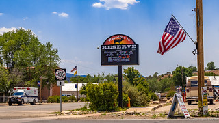
Reserve, gearing up for America's Birthday!

I like this more than I probably should. Good thing it's several states away.
Ultimately, we decided to eat at a local Mexican place called Carmen's. This was a mistake - one of two we'd make in the span of about 15 minutes. We once again opted to sit outside, and ordered what seemed like straight forward plates - enchilada verdes for the lady, and carne asada with guacamole for me.

Don't eat here. It is not authentic, Mexican, or American.
Neither meal was good, but most egregious was the fact that my carne asada was delivered as a red-sauce based soup, with no guac, and it was pork. When I mentioned this to the waitress, she offered to bring me some guac and assured me that it was carne asada.

Strangest grilled beef skirt steak (carne asada) I've ever seen! Chile Colorado with pork, maybe...
In the end, we paid our fare and left hungry. And that's when we made our second mistake... as we set out toward Luna, on the fourth leg of the New Mexico BDR.
The Whole Story


Love Backcountry Discovery Routes? Check out the
BDR Index
for all the routes I've run - they are fabulous!


")
")
")


")
Hi turbodb, This is INBONESTRYKER FROM twworld. I'm also ████████████████████ - well, at least until 7/31 when ████████ will deconstruct with pieces forever lost in cyberspace. My new email is shown below; please change at your end new where ever it needs to needs to be in order for me to continue receiving your wonderful trip reports. This one is particularly enjoyable as my only excursions to NM only had interstates for entertainment because i- not quite true. I did a backpacking trip to Bandelier NP (was a monument when I was there).
May the rest of your trip be more or less uneventful.
Hey John, Sorry for the slow reply on this - I've been out in the Sawtooth's of Idaho the last several days (though with all the smoke it was hard to see them)! Everything is updated on this end and you should continue to get trip reports. Glad you're enjoying everything and reach out any time! ?
It's strange. I have done a little exploring in NM and driven through much of it transiting and have watched a lot of video of stuff in NM. It really seems like BDR phoned in this one. Or were maybe afraid to have even more pavement to get to cooler areas. You could drive an 18 wheeler 55MPH down most of those roads lol. Better scenery than where I live and still love reading the report but it confirms NM BDR as a low priority for me.
I am dying for them to get the Wyoming one done.
I'm with you 100%. I've got some ideas as to what is going on with this BDR, but I'll save those for the end of the trip, just in case something changes between stage 3 and stage 7.