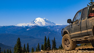
There's nothing like waking up in the morning when you hit the sack on the top of the ridge with a view of one of the largest mountains on the west coast.

I hung out under the warm covers for as long as I could stand it - really only a few minutes in earth time - before climbing down the ladder to take a few shots as the sun came up over the horizon. Unlike the previous evening, the sky was cloudless, so there was no amazing overhead display - but that didn't mean the experience lacked in the drama department.


It was still a bit chilly as I snapped a few photos, and given that nothing about this trip was rushed, I headed back into the tent to enjoy my book and view for another hour or so before @mrs.turbodb got up to make breakfast - cereal with fresh fruit. Once again, as she was productive in the food department, I wasted time taking photos and starting to get the tent put away. Really, I just couldn't stop looking at Mt. Rainier.


Uh oh, the stitching seems to have ripped out of the heavy duty CVT straps!
Half an hour later, and just before 9:00am, we were back on the trail - only a short section of Manastash Ridge between us and the road down to Shoestring Lake, and then ultimately Tripod Flats.

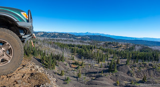
A benefit of the burn: there's always a view of Mt. Rainier.
That road - it turned out - had been adopted by the 4x4x Northwest and would prove to be just as tight and technical as Manastash Ridge the day before... if not a little tighter and more technical. But now I'm getting a little ahead of myself, as usual - at this point we were simply turning east towards Shoestring Lake.


We had quite a bit of elevation to shed on our way from the ridge to the lake, and several times through the morning, we'd nearly double back on ourselves - without even realizing it until we looked out and recognized a place we'd recently been - as we meandered our way from plateau to plateau. To our delight, the first plateau offered a few top-of-the-world style overlooks, and we took full advantage.


@mrs.turbodb wasn't happy about taking this photo.
Shortly after reaching that exciting overlook, we wound our way down into the lava-rock field below. Well, we didn't so much wind our way, as point the truck downhill and let the engine do the majority of the braking. As usual, things look flatter in photos than in real life, but the truck flexed here and there in just the right ways as we stepped down through loose rocks and ledges that ranged up to a couple of feet tall.


At some point, we also passed this sign - conveniently letting us know that we were on a rehabilitated trail to "oestring lake," and that we were in some location that had been shot up.  At least, that's how we read it.

More narrow trails and 5-point turns ensued - the 1st gen Tacoma just barely squeaking through several spots on the trail, and even then, I was hyper-vigilant as the sliders would contact standing dead trees, since I knew from experience that those could find their way into body panels if pushed just a little too much.
Oh, and we kissed the rear diff drain plug on a root. Fun times.


Eventually, we made it down several steep sections, and wound our way over towards the lake. We still hadn't spotted it by this point, but crossing a bridge and travelling on excavator tracks embedded in the trail was a good indicator that - at least in some season - there was water nearby.


And then, finally - as we were essentially "next to" Shoestring Lake on the topo map we were using in Backcountry Navigator XE - we got the fullest view we would of the lake itself. A little anti-climactic to say the least! 

From the lake, the trail never got good, but it did get a little better - or at least wider - as we continued on towards Tripod Flats. @mrs.turbodb and I wondered about this at the time - initially chalking it up to proximity to the trailhead, before stumbling upon a nicely appointed hunting lean-to - which was of course and indicator of increased traffic and accessibility.

Fifteen minutes after stopping at the first lean-to, we'd arrived at Tripod Flats. This reasonably large clearing in the woods is home to what was clearly - at one time - a nice cabin, as well as a splendid summer camp fire area with views of the meadow.


Now a couple hours into our day, we used Tripod Flats as a bit of a break from the constant bumpiness of the roads and mental workout I'd been getting as I tried to keep the sides of the truck out of the trees around some of the tight turns. We explored the cabin, a couple of poo palaces out back, and I couldn't help but notice the happy-looking, patriotic-lei-draped bear, that'd been impaled on a nearby a tree.


Even though we were both hungry, it wasn't quite lunch time and we had quite a few miles remaining on the day, so we piled back into the truck and continued our journey south - our westerly views momentarily blocked by the surrounding forest, but views to the east splendid, still.

It wasn't long however, before we broke out of the woods and had a decision to make: head southwest towards the highway (WA-410), or continue southeast a few more miles to a place I was pretty sure we would be visitors of the "look but don't touch" variety - Funny Rocks and Moon Rocks.
Oh, and we got to make our decision with another nice view as the backdrop.

This view really never gets old.
In the end, we made the decision the same way we seem to make all these types of decisions - we were here (and who knows when we'd be back) so why leave anything out? We figured that at the very least, Funny Rocks and Moon Rocks might give us a nice place to eat lunch, so we pushed forward, finding ourselves at the final approach to Funny Rocks some 12 minutes later.

Surprisingly, Funny Rocks - which I'd found a video for on YouTube that made me think it was craziness for buggies - had a line that seemed "Tacoma Friendly." Of course, I did find a u-joint cap at the base of the line, so not everyone escaped unscathed.


A few minutes at Funny Rocks, and we agreed that our next stop at Moon Rocks would be the perfect time for lunch. It was half-past twelve and a shady spot overlooking the moonscape made for the perfect place to assemble tuna sandwiches and break open a bag of jalapeño kettle chips. Yum!

Moon rocks - at least as we experienced it - was significantly less interesting that Funny Rocks, and so after lunch we sort of just drove back the way we'd come, and then out the route we'd passed earlier - Milk Lake Jeep Trail - to WA-410 - several more views of The Mountain experienced along the way.


When we popped out at the bottom, it was somewhere around 2:30pm, and a glance at our fuel gauge indicated that the last couple of days in 4Lo had taken their toll - even though we'd filled up less than 100 miles earlier, our tank was less than half full and we were going to need gas to complete the rest of the trip. Cliffdell - though the opposite direction from where we were headed - wasn't far to our south, and we hoped they'd have fuel available. As we drove through town, we saw nothing and eventually pulled to the side of the road to consult our Washington state map for the next nearest town. That turned out to be Naches - about 20 miles away - a bummer, but the smart move given our single-truck status. We pulled back into traffic, and about 300 feet up the road, just around a little bend, there was a gas station!
At a place like this, the prices weren't the lowest - but they saved us 45 minutes of driving, and for that, we were thankful!

A chopper attending to the Jungle Creek fire flew low overhead as we filled up with fuel.
The truck replenished, we headed north on WA-410 for 10 miles or so until we reached the turn off to FS-19. We'd originally planned to take this route to explore FS-1902 up to Ravens Roost, and then as our access to the Naches Trail, but the Jungle Creek fire changed all that, closing access to FS-19 right at the beginning of the road.

We had a quick chat with the USFS Ranger who was stationed at the road closure, confirming that we'd still be able to run the Naches Trail from the west side, and then hit the highway for a good 50 miles - on our way to a couple roads that we hoped would have the perfect camp spot for us to enjoy the mountain from only a few miles away and be a good jumping off point for Naches the following morning.

Up and over Chinook Pass.
We eventually found ourselves on dirt again, winding our way through a myriad of clear cuts, mature forest, and shelf roads to investigate three possible sites where we might spend the night.

In the end, all three sites would have been completely suitable, but with no one else around on this beautiful Tuesday evening, we - responsibly - opted for the one with the best view. Nestled in the trees and so sheltered from any significant wind, we really couldn't have asked for more, and we settled down to foot-long hotdogs and some more of those sungold tomatoes for dessert!

Dinner done, we followed a familiar routine as the sun set to the west. With fewer clouds than we'd had the night before, the colors weren't as dramatic - but the proximity of a towering mountain more than made up for that as far as we were concerned.


By the time the sun was all the way down, nearly all of the clouds in Mt. Rainier's self-generated weather system had dissipated, a half-moon lighting the sky as we nodded off in the tent. It'd been another full day of technical trails, and both of us were ready for a bit more in terms of "things to investigate along the way."
Little did we know that we hadn't really experienced anything in the way of "technical" yet; that would come tomorrow as we finally embarked on the impetuous for the entire trip: The Naches Trail.


Thanks for these well written trip diaries! I am enjoying the photos as well!
Glad you're enjoying Skyler! It's fun putting the stories together, and hopefully they help others get out to explore these (or other) places!
Did you know that your mother was going to see that photo of you hanging out over the cliff??
Never really thought about it. I'm sure she'd have heard if something went terribly wrong.
Very nice! Thanks for posting! Such incredible views!
Omg I love reading and seeing you two's adventures you just put me there with you. Love it
It’s awesome to hear when folks love the stories Steven, glad you are enjoying them, and hope you enjoy many to come!