
Sleep came quickly on our tailings platform nestled into the drainage high in the Panamint Mountains. Sheltered from the wind, and with temperatures in the low-40°F range, it was one of the most pleasant nights of sleep I've had in a long time. It wasn't quite as good for @mrs.turbodb, but she certainly welcomed the nearly 11 hours of shut eye after the slog of driving we'd endured over the previous 48 hours.
I'd set my alarm for just before sunrise, but my internal clock was having none of that silliness, and I awoke three minutes before Toto's Africa came blaring out of my phone. I pulled on my clothes and climbed out of the tent, happy to explore the bits of Tucki Canyon that I hadn't gotten to the previous evening.

I ended up wandering down the canyon a tad more than a mile to the end of the old mine road - at a gaggle of rocks and dry falls making further wheeled travel impractical. Besides trash that'd washed down the canyon over the last hundred years, there wasn't much to see, and 45 minutes later I was back at camp - to a much more cheerful (than the previous day) companion who already had breakfast-in-hand. 

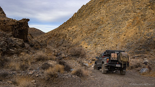
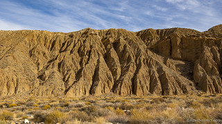
Soon, with breakfast and camp wrapped up, we were bouncing our way back up through Tucki Canyon, over the ridge, and down Telescope Canyon towards our next destination. It was a beautiful day with cool-but-comfortable temps - all you can ask for when visiting this place known for heat.


As I was out of the Tacoma - through the window, mind you, since I couldn't open the driver door in the squeeze - I happened to glance up a short side-canyon nearby and noticed the most amazing outcropping of copper. The color rivaled that of any we've seen, and was reminiscent a mine we found at Echo Pass earlier in the year.

From Telephone Canyon, we headed south, passing Emigrant Springs before arriving at our next two destinations. The first - Journigan's Mill - is located right on the side of what is now a paved road. As you can imagine, that means it's rather highly visited, and well picked over - not much more than a set of concrete foundations and a couple tanks at this point.


For several decades the site that became known as Journigan's Mill processed gold and silver ore from nearby mines, including the Skidoo mines and the Cashier Mine at Harrisburg. Local processing was an important step in reducing ore volume in order to lower transportation costs and enable profitable mining in remote areas. The mill's location was dictated by the proximity of springs in two nearby canyons, which provided the water needed to run it.
The area saw its first activity perhaps as early as 1909, when Skidoo, across the hills to the east, was three years old, mill-less, and booming. The first documented activity dates from about 10 years later, when Carl Suksdorf and Shorty Harris ran a custom ball mill for local miners. However, this site did not fully expand until 1934, when the Gold Reserve Act raised the price of gold from around $20 to $35 an ounce, prompting the revival of mines at Skidoo and Harrisburg. In March that year, Roy Journigan and a few partners filed the first claim on this site, which they called the Gold Bottom Mill Site. Later on, Journigan acquired his partners' interests and formed the Journigan Mining and Milling Company. With a capacity to treat 25 tons a day, his plant was the largest around. It had a stamp mill, a cone-type ball mill, a crusher, amalgamation plates, and cyanide vats. For several years, ore from the tunnels and dumps of the Skidoo and Harrisburg mines was trucked to the plant, where it was crushed and treated before being shipped out.
After Journigan sold the mill in 1939, the site remained busy for years, finally closing down in the late 1960s, when the Argentum Mining Company moved the machinery to Columbia Flats, Nevada. It had been active longer than any other in the park.Hiking Death Valley

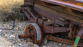
Despite the sparse nature of the mill itself, we did discover a few interesting vehicles nearby and spent a few minutes checking them out. It's amazing, really, how many vehicles are simply left to rot in the desert.


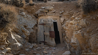
The second destination - the ███████████████████ Mill - was not too far away, but its mile-or-so buffer from the road meant that approximately zero people visit it on a given day. Perfect!


If there was a theme so far on this excursion, it was rusty cars, and this mine site was no exception. There, parked in front of the cinderblock-and-stucco cabin was a veritable cornucopia of vehicles. All were in extreme states of disrepair, but it was clear that some of them had once been quite fancy.


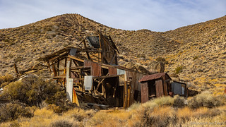
Our next stop was the cabin. Made of stucco over cinder block, it has weathered the elements better than most structures in the desert and still had recognizable insides. Rodents and time have taken their toll - I wouldn't want to sleep here - but stepping inside was like stepping back 75 years in time.


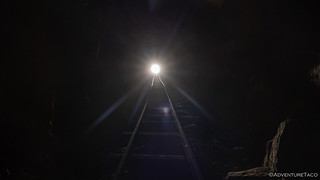
Having enjoyed the longest hike we'd take during the day, we climbed back in the Tacoma and soon we were on dirt again, this time headed east - toward Skidoo. This road - as with the remainder of the roads we'd explore this time - was nicely graded, to the point that being aired down was unnecessary. The lower pressures did make things more comfortable however, so we let the tires be as we once again wound our way into the Panamints.
I'd forgotten that I'd noticed a cabin and headframe when I'd planned the route, but as we reached the halfway point to the old mining town, we spotted both - on opposite sides of the road. Both the cabin and headframe seemed to be in reasonably good shape, and I found myself wondering if this would be like the handful of other cabins in the park that are lovingly maintained by a core group of people.


After wandering to a few nearby adits and diggings, we were both starting to get hungry and figured that we ought to find somewhere to eat once we got to Skidoo. Of course, we had no idea what to expect when we reached Skidoo, and while there was nothing in the way of old buildings - the few houses that were not dismantled and moved (an old desert tradition) now reduced to rubble, a couple of mine shafts quickly distracted us from the task at hand.


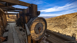
I found my fellow explorer napping in the truck, the sun warming the cab to just the right temperature and after filling her in on the maze I'd discovered, I asked her if she'd been down to the end of the road beyond the mine. In fact, she had, and told me that it led to the Skidoo Mill - the whole reason we'd come to Skidoo in the first place. I wasn't going to miss that, so once again, lunch had to wait.
Note: The Skidoo Mill is not stable and the National Park Service has posted signs asking visitors to stay off of the structure. There are plenty of places on the hillside to photograph this historic structure.

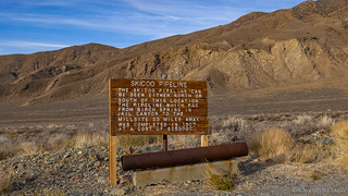
Powered by water piped from Birch Spring - high in the Panamint Range and over 20 miles away - the Skidoo Mill was the only water-powered mill to extract gold from ore in Death Valley, and was the areas second most profitable operation.

Started by a major gold discovery made by John L. Ramsey and John A. Thompson in January 1906, the two were caught in a rare fog that forced them to camp in Emigrant Canyon. Tracing the find to a giant lode, they caught the attention of E. A. (Bob) Montgomery, who purchased the claims and formed the Skidoo Mines Company.
Before long most of the surrounding ground was claimed and the town of Skidoo was laid out to support the increasing population of workers and merchants attracted by the boom. Its name was derived from "23 Skidoo," a popular phrase of the time that meant "beat it." Despite the name, Skidoo became the largest community in the Panamints and the only real town Death Valley ever had. At its height, it had a population of 400-500, and over 100 business houses and residences, offering such amenities as a bakery, a school, several restaurants, a physician, the Southern California Bank of Skidoo, and a newspaper, The Skidoo News.
Gold production started in May 1908. The ore was hauled from the mines directly to the mill in trains of mine cars pulled by burros. For quite some time, tens of tons were processed every day, yielding from $5,000 to as much as $18,000 a month and by 1909 the Skidoo Mine was the second largest gold producer in California after the Keane Wonder Mine.
The great Skidoo era lasted until September 1917, when the main ore bodies were played out or became too difficult to exploit. The area still witnessed sporadic activity for many years, and several mines were reopened in 1934 after the price of gold went up, but the heyday was over. By the end of 1917, Montgomery's mine had produced over $1.3 million. It was the only mine of the Death Valley gold rush that brought back dividends to its stockholders.Hiking Death Valley


Finally - our exploration of the mill complete - we couldn't delay lunch any longer. Finding ourselves a fantastic overlook, we could set up our chairs and enjoyed sandwiches with a view.

On our way out of Skidoo, we opted for the less-direct route, winding through the hillsides, amongst dozens - or hundreds - of workings. The most intriguing of these were a series of trenches, where gold was mined from quartz veins. The veins were thin - 18 to 24 inches wide - but impressively deep and nearly 100 feet long! Mining was difficult, as the trenches were prone to collapse, requiring miners to support them with timber logged near Telescope peak, now more than 100 years ago!


On the well-graded roads again, I'd mapped out an all-dirt track to our next destination - Aguereberry Point, with a quick stop in Harrisburg (Aguereberry Camp) - but the road I'd hoped to take is now in a wilderness area, so we made a quick jog back out to Emigrant Canyon Road before pulling up to the parking area for Harrisburg.


We followed a winding road as it circumvented the hillside behind camp. A half-mile or so up the road, the main workings of Pete Aguereberry jutted from the rocky surface - we'd found the Eureka Mine and Cashier Mill.
Gold from the Eureka Mine sustained Pete Aguereberry for 40 years. Records show that Aguereberry extracted and estimate $175,000 worth of gold - nearly 9,000 ounces, then valued at $20 per ounce - from Providence Ridge during his lifetime.
In recent years, the Eureka Mine has become a winter home for the endangered Townsend big-eared bat, and for many years the National Park Service would close the shaft when they were using it, only allowing people to explore the mine when no bats were present. However, the shaft has now been barricaded with steel like so many others - the risk of liability just too great.


On the southern slope of Providence Ridge, just behind the Eureka Mine, the Cashier Mill - built in 1909 - stands on old concrete footings. Originally powered by gasoline engines on nearby pads, the mill crushed the ore before chemical processes - using mercury and cyanide - extracted the gold.


As we poked around the camp and mine, and as is often the case on weekdays in the airspace above Death Valley, the roar of military jets had filled the sky. Naturally, we were rooting for an entire squadron of F-35s to come tearing over the landscape, a couple hundred feet off the ground, but we had no such luck this trip. We did however see a rather large plane being escorted - we thought - by a couple fighters.

The planes completed at least four complete circles in the air overhead. It was only upon inspection of my photos (at 240mm) that we later realized what was going on. This was no escort, it was practice.

The main reason we'd headed this direction wasn't for Harrisburg at all - rather, it was for a location, 6,433' up in the Panamints: Aguereberry Point. Offering one of the most expansive views on the western side of Death Valley, we could see more than 90 miles - from the salt flats of Badwater Basin to the Nevada's 11,900' tall Mt. Charleston in the distance.


Having enjoyed the view that Pete Aguereberry reportedly loved enough construct a road that would allow him to show it off to visitors, we climbed back into the truck for the six-mile descent back to Emigrant Springs Road. It wasn't yet 3:00pm, but with only 90 minutes until sunset, it was time to start making our way toward camp.

We followed Emigrant Springs to Mohogany Flats, once again winding our way up into the Panamints - this time, higher than we'd been at any other point on our journey. In fact, the plan was to camp at the highest campground in the park - Mohogany Flats. Campgrounds are a rare occurrence for us - we much prefer the solitude of a lone ridge or wide-open alluvial fan - but we weren't optimizing for the evening.

Rather, we were optimizing for what we knew would follow the next day - the primary reason for the trip. Our goal - if we could muster the stamina - was to climb our way to 11,500 feet, and the highest peak in the park.
The Whole Story


Love Death Valley? Check out
Death Valley Index
for all the amazing places I've been in and around this special place over the years.
Awesome pictures! makes it slightly less unbearable for me when I can't get out to the desert!