
High up on a ridge in the Funeral Mountains, we'd gone to bed with a gentle breeze blowing through the tent. It'd been chilly, given the time of year and our 4800' elevation, but not too bad - until midnight anyway, when the wind picked up. With gusts up to 15mph, the 32ºF air meant that wool caps, burrowing, and earplugs were in order as the tent buffeted around us for the remainder of the night.
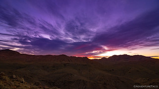
The silver lining in it all, were the clouds that were blown in, and as I climbed out of the tent just after 6:00am, I hoped to catch some color in the sky as I donned all the warmest clothes I'd brought on the trip!


While not the most dramatic sunrise I've ever seen, the pinks and purples always cast such an amazing glow on the landscape that they are surely an experience to savor. Rather than climb back into the tent - as has become a habit, especially when @mrs.turbodb is on a trip - I found a sheltered area below the ridgeline to simply enjoy the show.
Forty minutes later, the sun crested the horizon and soon @mrs.turbodb was on her way down the ladder - cognizant of the limited daylight and knowing that we had another full day ahead of us.
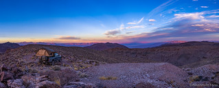

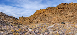
Our camp spot far up the middle fork of Echo Canyon had several things going for it: its position on the ridgeline, the associated views, and the fact that it was nestled at the end of an old mining road - mine shafts and ruins scattered over the landscape. All unprotected, it meant that we had to be careful walking around at night - but it also meant that we had plenty to explore as we enjoyed cereal and fresh berries for breakfast.

Our poking around took a bit longer than I think either of us thought it would, and it was 7:30am before we finally pulled out of camp - happy to be in the confines of the cab, where the heater could help take the bite off the still-breezy-and-cool morning air!

We didn't have far to drive - less than a mile to be certain - before our first stop. When scouting this location in my pre-trip route planning, I'd noticed an extremely green patch of land nearby that could only mean one thing: copper mine. There's something about finding a bright green rock - the copper patina such a distinctive color - that's alluring, especially to @mrs.turbodb, and as we hiked the small summit to the waypoint I'd marked, it was clear that this spot was going to be a winner.
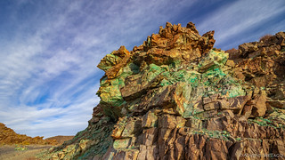
We had no details on the mine that once worked this area, but the amount of copper ore here was - for us - jaw-dropping. Sure, it wouldn't hold a candle to larger copper mines, and it was surely smaller than the Copper World Mine we'd visited on our Mojave Redemption trip, but the greens were so vibrant - we just kept picking up piece after piece to show each other in glee.


We also knew where we'd camp if we ever find ourselves in the area again as evening is approaching. The views aren't quite what we had further up the ridge, but how could we pass up a green fire ring?

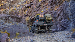
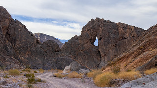
After gawking for several minutes in the early morning sun, we retreated from the summit - back to the Tacoma waiting below. Once there, we didn't have far to go - as retraced our path down Echo Canyon - before we reached the narrow dry fall that we'd encountered the evening before.

No longer trying to find camp before dark, we had a few more moments to savor this interesting couple hundred feet of road, and I took full advantage.

If you're a fan of Death Valley and have explored some of its more popular routes, you may be familiar with Steel Pass and the narrow falls in Dedeckera Canyon. The best way I can describe this hundred-foot-or-so section of Echo Canyon is the narrowness of Dedeckera, with about 2-3 times the height of the tallest fall there.


Through the narrows, the remainder of the canyon was a walk in the park for a vehicle like the Tacoma, and we made good time - having already explored the Inyo Mine the previous evening. Naturally, we made a few stops here and there as captivating views presented themselves.

The floor of Echo Canyon varies in width, with the upper canyon - both above and below the steep dry fall - being wider the thin rock layers packed one on top of the other before being mashed into various shapes by the geological pressures of time.
The middle of the canyon tightens up - never narrower than 25 feet, but with walls towering above, it can feel narrower. This is the section where Eye of the Needle Arch decorates the center of the wash, a great place to climb up for a birds eye view of the dramatic surrounding.

From the narrows, it's a slalom down the bottom of the wash and out the alluvial fan to CA-190 where we headed north just a couple of miles to Furnace Creek. Our stop there was short - just long enough to renew our annual America the Beautiful pass - before crossing the street to Texas Springs Campground - the jumping off point for our main attraction for the day.
You see, our plan was to spend more than 50% of the daylight - some four hours or so - on what we hoped was an epic hike up the Funeral Canyon, deep into the Funeral Mountains. Promising a nearly 1-mile long slot canyon, climbable 7- to 20-foot dry falls, as well as badlands and hoodoos, we knew that this could be a special place.
What we didn't know - as we set out up the alluvial fan - was that we'd have the entire thing to ourselves for the day!
But, I'm getting slightly ahead of myself in my excitement to tell the story. Before heading out, I oriented the truck so the windshield was facing south, and setup the solar panel to keep the batteries topped off as the fridge worked to keep our food chilly. Even with the partly cloudy day, this worked a treat, generating over 200W of power in the time we were gone.
While I did that, @mrs.turbodb prepped lunch - something I'd envisioned eating on our return, but that we decided, smartly, to take with us into the canyon.
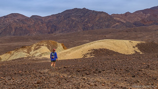
Only then did we set off up the alluvial fan, our pace quick in the well-worn burro trail - an 8+ mile round trip, with 1700' of elevation gain in front of us.

It was about half a mile in that I realized I'd forgotten my Fitbit, and I jogged the round trip back to the truck to grab it - the thought of losing credit for those miles more than I could bear. 
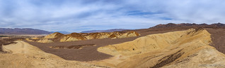
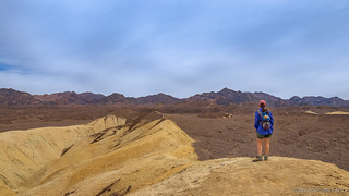
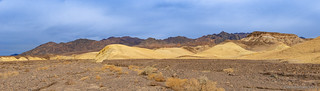
I caught back up to @mrs.turbodb as she reached the badlands - a little less than 1.5 miles up the alluvial fan. The East Coleman Hills, these yellow mudstones are draped with a veneer of dark-brown rubble, the remains of several tunnels that have been bored into their base still visible all these years later.
We paused only briefly to take in the scenery around us before continuing on. Even with nearly two miles behind us, we still had more than a mile to go up the alluvial fan before we even reached the narrows that marked the beginning of the Funeral Canyon. Already though, we could tell that we were in for a treat.
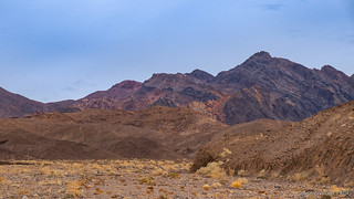
Even before reaching the narrows, sections of the wash began to rise up and sink down around us - the tall fanglomerate walls towering dozens of feet above our heads. The enormous amounts of water needed to form these structures is hard to fathom, especially in a place as parched as Death Valley.


A little more than one hour and fifteen minutes into our trek, we'd covered the 3+ miles to the start of the narrows, and found a rock in the middle of the wash on which to eat our lunch. It was still just a little before noon, but we figured that much of the hard work was behind us now - no reason to keep our rumbling bellies waiting any longer.


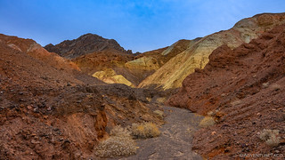
Eager to see what lay ahead, our lunch was a quick one - the anticipation of the slot canyon a little further up the wash, more than we could bear to postpone. We headed into the narrows, dramatic walls with cavernous carvings drawing us forward around each subsequent turn.


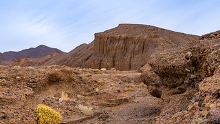
The walls at this point were primarily burnt orange in color, but a closer inspection showed them to be made of a kaleidoscope of rocks, each one embedded as though surrounded by cement.

Through this part of the wash, water had carved its way through the fanglomerate, creating sweeping overhangs that would have kept us shaded even in fullest of sun.

And then we entered a side canyon - our ultimate destination for this stroll. It was here that we'd experience the dramatic slot canyon, the grainy surfaces of the walls bristling with sharp, colorful stones. Not much grows in this section of the canyon, some places never receiving direct sunlight. Even on the brightest of days, I'm sure that this perpetually dim canyon - its towering walls hollowed by rushing water, chockstones wedged mere inches above our heads - creates wondrously unsettling spaces. It is a mysterious underworld that inspires respect and silence. With no advance warning of what lies ahead, the suspense is constantly kept alive.


Not everything is easy-going in the slot. Expectedly, chockstones make passage more difficult, but there were only two spots where we really had to resort to climbing. The first was only a few dozen feet into the slot, where the aptly-named Tunnel Fall required a couple climbs of 10 feet or so in order to continue on.

The second climb was a bit more difficult - perhaps 15 feet up a rather steep, slightly overhung fall that was more of a concern coming down than going up. But the reward for each of these was well worth it, as we continued up - and eventually out of - the slot canyon.
At the top of the slot, the landscape changed dramatically. Here, above the last dry fall, the fanglomerate ended suddenly, revealing yellow, red, and green hills even more colorful than we'd seen in the lower canyon. What a treat!


Soaking it all in, the canyon continued only another quarter mile or so before ending - for us - at a 60-foot tall wall known as Chimney Fall. I'm sure some make it past this point, but without ropes and a bit more experience, this was the end of the line for us!
Sort of.
We still had half the hike to go, simply in the opposite direction from which we'd come. And that's a great thing about slot canyons - the view in the opposite direction is always a new experience, the Funeral Slot Canyon being no exception!

Eventually of course, we reached the mouth of the slot, and then the mouth of the narrows, before treking down the alluvial fan that had ushered us into this spectacularly private experience only just across the street from one of the most populous areas in the entire park! We made good time on the way down, stopping only to empty our shoes of pebbles and admire the views around us.
We reached the Tacoma three-and-a-half hours after setting off, having kept up a reasonably good pace for the 8-mile journey, especially when factoring in the fact that we stopped for lunch along the way!
Not that our pace hadn't taken a bit of a toll; we were both ready to get off our feet and spend a bit of time letting the truck do the work of moving us along - a good thing given that we had a 75 miles of pavement to cover on the way to a place I'd been wanting to visit for nearly three years.
So, it was back onto CA-190, where we headed north and then west over Towne Pass into Panamint Valley. This section of road was familiar, having just travelled it - for the first time - only two weeks earlier on our way to the Nadeau Trail. But this time, we didn't stop in Panamint Valley at all - not even for fuel - instead, we continued west, winding our way up towards and past Father Crowley Point.
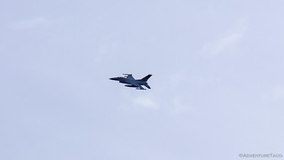
It was here along CA-190 that we were treated to a fly-over of two F-16s, their engines roaring as they banked down into Panamint Valley. It was a bit of a surprise, really, given that Star Wars Canyon was just one ridge over, and is likely a more popular route!
Even having gotten an early start on the day by exploring Echo Canyon the evening before, having made great time on our hike, and having travelled the speed limit on pavement for nearly 90 minutes, we found ourselves turning north on Saline Valley Road just after 3:45pm - a mere 45 minutes before the sun would drop below the horizon.
And so, there would be no exploring Hunter Mountain or Hidden Valley today - we'd be lucky to reach our planned camp spot by dark. But that was fine by us - we'd enjoyed ourselves thoroughly, taking the time we needed to explore what was around us as it presented itself. Plus, we still had another day to immerse ourselves in this spot I'd been trying to get to for nearly three years.
But hey, that's another story...
The Whole Story


Love Death Valley? Check out
the Death Valley Index
for all the amazing places I've been in and around this special place over the years.
Thanks again for sharing, the photos as always are spectacular. Great adventure!