
A combination of ear plugs, not much wind, and sleep deprivation over the previous couple of nights meant that we slept pretty darn well on our Molen Reef overlook. And by "we," I really mean "me," because unfortunately @mrs.turbodb didn't have quite as restful a night as I did. So, as I climbed down the ladder in order to catch the light of day breaking over the horizon, she snuggled down deeper to get a final hour of sleep before I returned to camp and it was time for breakfast.


Unlike the previous morning where we didn't even get up until the sun had made its way well into the sky, we were eating breakfast and packing up just a few minutes after sunrise, and on our way down to Moore Cutoff Road by 8:00am. As with all the roads so far - except the last mile or so of Short Canyon - this one was a little bumpy but otherwise uneventful, and our descent through the Junipers was a pleasant one.


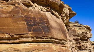
As we headed east along the few miles of pavement we'd see all day, we made a quick stop along a side spur in search of some petroglyphs. Described to us the day before - when we'd met a couple of hikers on our way out of Short Canyon - we never found them, but we did happen upon a glyph that seemed even cooler!


In high spirits after our discovery - it's always fun to find a panel that was unexpected, even if it turns out to be relatively common and well-known - we continued east before turning north onto Sand Bench. An out-and-back trail, I was looking forward to the couple-mile hike at the end into Red Hole Draw, where we'd hopefully discover a wonderland of goblins as well as - naturally - more rock art!


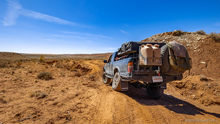
Twelve miles of dirt later, we arrived at our trailhead. Actually, first we drove right by our trailhead because we were curious about how far the road continued, but when it became apparent that it didn't continue in the direction we were going, we turned back and found a good spot to park. At this point it was right around 9:30am, and the sun was excelling at its effort to warm the landscape, so we donned our shady hiking gear and slathered our uncovered bits with sunscreen before heading down into a wash that would funnel us towards Red Hole Draw.


We had about a mile of wash and a couple hundred vertical feet to traverse before we'd reach Red Hole Draw, and along the way we were treated to several interesting distractions. I hadn't been sure if this hike would really be worth it - being that it was all alone at the end of a reasonably long road - but I must say that it turned out to be great!


Even as we left Funk's cave at near the bottom of the wash, it wasn't until we rounded another reasonably large bend that we got our first glimpse of the Red Hole Draw. "Ball valley" is - I think - what @mrs.turbodb called it as it came into view, which seems a very apt name if you ask me. Apparently this is similar to Goblin Valley (which we've not visited), though on a much smaller scale.


It was only a bit after 11:00am, but after hopping around from spot to spot to try to capture the alien landscape, our tummies were getting hungry so we headed back toward our mobile kitchen. As usual, even when we're trying to make good time, a few more things caught our eye, but eventually we found ourselves enjoying turkey-and-salami sandwiches with quite the view.


Our sandwiches - a change from the tuna we've taken to eating most days - were fantastic, and as we munched our way through them (and some satisfyingly salty potato chips), we planned out our next move. The rest of the day would be more of the same - driving, hiking, and searching for rock art - and I hoped we'd be able to camp at the location I'd planned to camp the previous night. Looking at the map however, it seemed that we might be able to save a mile or so by hiking to a spot I'd marked as Big Cave from our current location, rather than a trailhead off of Sid and Charley Road.
So, we got the truck packed away - and moved a little way to the top of a different wash - and set off in search of our next destination.


In the end, we hit an unpassable dry fall about a quarter mile before reaching the Big Cave. A little bummed, but knowing that was the risk we'd taken with trying this alternate route, we headed back to the Tacoma to enjoy the air conditioning as we retraced our path through Sand Bench, flexing a little bit as we traversed one of several washes that hadn't gotten the memo that they were crossing a road.

For nearly its entire length, the road we'd taken along Sand Bench was less than a half-mile west of our next road - Sid and Charley Road. Both skirting the same formation, Sid and Charley worked along the valley floor, compared to our previous path along the top of the bench.

With several little hikes planned along this route, we decided that we'd head all the way to the end of the road - to tackle Big Cave, hopefully with more success - before circling back to hike, and find camp a little further south.


We reached the spot where I thought we'd find Big Cave - to the point where we could even see the place to which we'd descended previously - but to our surprise, there was nothing but wash. Undeterred for the moment, we split up to explore a few nooks and crannies, hoping that a small entrance might lead to a larger cavern.
Nothing.
"Maybe it was a mud cave," I proposed to @mrs.turbodb, "and it collapsed."
Defeated - perhaps an easier task than it should have been - we decided that we might as well continue up the wash to the dry fall that had stymied us from the other direction - at the very least, giving the hike a destination. And, it was as we took just a few more steps in that direction, that I spotted the cave!
Making my way up the steep, loose, narrow trail, I'd just entered the opening when a Barn Owl dropped out of a small hole and right past my head. Fumbling as quickly as I could, I knew there was no way I could snap a photo, but I gave it a shot anyway.

After excitedly sharing the story with my hiking companion - who was still on the way up the side trail - we headed back to the wash and shortly found ourselves at the bottom of a series of dry falls that had hindered our progress previously.

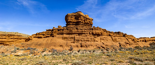
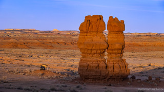
Taking a slightly different path back to the Tacoma, we soon found ourselves headed south, back towards the Sid and Charley hoodoos for which the area was named. Though it was only 3:30pm, we planned to camp at the hoodoos, meaning that even with the 3-mile hike we had planned to view a bunch of rock art, we were likely to be in camp early this evening.

As we pulled into the area around the hoodoos, I have to admit that we were a bit disappointed to see a group of folks already there, climbing the rocky towers. Still, we knew that there was a good chance they were only there for the afternoon - which they later confirmed to our delight - and so we set off on our hike, in search of a man with a broken heart.
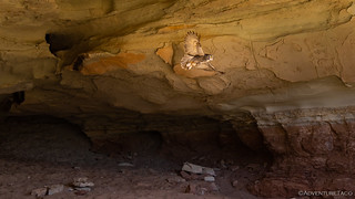
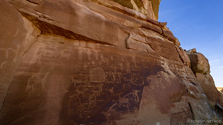
We'd find our Broken Hearted Man eventually, but first we made a quick stop at a vast sandstone wall. With a dark patina, it seemed the perfect place for a bit of artwork, and after a little binocular-ing, we made two interesting discoveries.


Continuing on our loop, we had a very enjoyable mile of hiking before any more rock art. Along the way, buttes, wind caves, and erosion kept us entertained as we sought out firm footing in the hard-to-walk-in-sandy wash.


And then, above us, a crying man with a broken heart - we'd reached the best-known panel of this area, and one that - while not all that remarkable - was one I'd been looking forward to since I'd seen it in a couple other trip reports.


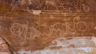
The area contains several panels of petroglyphs and we spent a little time looking around at the rest of them. One of the things that struck me was how uncrowded the panels were compared to most that we find. There weren't a lot of overlapping petroglyphs, and there was plenty of space for more!


Continuing along our loop, I spotted what I thought might be a shortcut to the adjacent wash where we expected to find some more panels, and after a bit of scrambling, let @mrs.turbodb know that she should follow me up and over. Neither was a problem, though the over part ended up taking a while as the panels we were looking for just happened to be at the apex of our climb.


The out portion of our loop had been a little more than a mile and a half, and it was just a few minutes after 6:00pm, when we finally arrived back at our starting point. The climbers were still at it, two of them basking in their success at the top of Sid and Charley.

Hungry after another long day in the sun, we pulled the truck around to the shade of the hoodoos - which also happened to protect the tailgate from the breeze - and proceeded to make dinner. With two hours before sunset, it was a nice change - making and cleaning up dinner with daylight to spare. Plus, we had a front row seat for the action as we consumed our tacorittos.

In good time, the climbers packed up their ropes and harnesses and all five of them piled into their Dodge Ram - a tight squeeze, and one that probably didn't smell so nice after they'd all sweated their way to the top of Sid and Charley - and we were left to admire the last of the light as it played across the sky.

And so, another fabulous day came to a close. We'd been in the Swell for two days, and - having planned to camp at Sid and Charley after day 1 - we were exactly one full day behind schedule. I had no idea if the trend would continue for the remainder of the trip, but one thing was certain - there was a lot more here to explore than we could see in a single visit anyway!
Little did I know that we hadn't even scratched the surface, and that the following day would bring bigger challenges than either of us ever expected.


I love the owl shot, perfect lucky timing. what is interesting is how did the couple get to the top of those tall rocks, another lucky shot, you da man!
Man, getting the owl was such perfect timing. Lucky timing, honestly. And the shot on Sid & Charley - well, that was easy since I was down on the ground, hahahaha!
Stay safe out there.
(and sorry for the slow reply, I just found a bunch of comments that were incorrectly marked as spam, so I'll need to dig into the guts of the site to figure out what's going on)
Great photos, love the petroglyphs. Looks like another great adventure. Two weeks and we are off for ten days of new territory.
Nice! That means you're off on your trip right now I bet - maybe just wrapping it up! Hope you had a good time, and I'd love to hear where you went!
Cheers, Dan
(and sorry for the slow reply, I just found a bunch of comments that were incorrectly marked as spam, so I'll need to dig into the guts of the site to figure out what's going on)
The pictures are fantastic as usual!!
Good job capturing the owl!!!!
Thank you!
Do we know the dates of this art? does only exist on rock walls? is the area it's in have anything to do with it?
is it divided into types by native Indian tribes or groups?
Hey Mark, My understanding is that the San Rafael Swell contains two main "types" of rock art - some of it is Archaic Barrier Canyon Style (BCS) and in the ~6000 year old range. There's also a lot of more recent Fremont style art, which is in the hundreds to couple thousand years old. The BCS art is primarily pictographs, and has much more detailed anthropomorphic figures, where the Fremont style focuses more on animals (often times bighorn sheep in my experience) and is more commonly petroglyphs.