
I can't really believe that I've been exploring the western United States for nearly five years now and have yet to spend any time in the San Rafael Swell. That's not entirely true - technically. I did camp one night on - what I now know to be - the extreme eastern edge of the Swell, just before a trip into The Maze with Ben @m3bassman and Zane @Speedytech7, but since then, I've never even driven through this amazing place on the highway!
This week would change all that. With eyeballs as big as saucers, I set about planning what I hoped would be an extensive foray into a place that I've only ever heard great things about. I knew it would be just the first of what would - hopefully - be many trips to this awesome place.
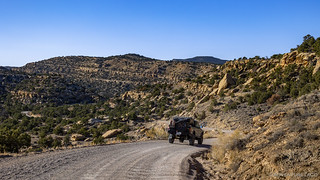
I had no idea at the time just how varied the San Rafael Swell really was; but, thinking I knew what to expect, we headed south. Some 18 hours later, and under the cover of darkness, we arrived in the Swell and set up camp. Something was oddly familiar, but I wouldn't put my finger on it till morning.

With not nearly enough sleep, a full itinerary pulled us out of bed after the sun had warmed the tent for the better part of 90 minutes. It was - at 8:30am - by far the latest we would climb down the ladder for the next several days! We quickly broke down camp, skipped breakfast, and were on our way.


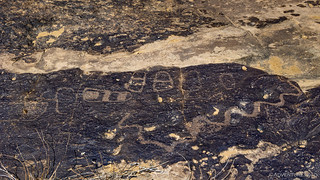
Our first planned stop was Mussentuchit Wash and a panel of petroglyphs that had been recommended to me by a fellow explorer. In fact, several of the places on this adventure had been suggested by Tim, a result of several years of his trips into the area - suggestions for which I'm extremely grateful. From our camp site, it was but ten miles or so of well-graded gravel road, and before long, we found ourselves parked at the trailhead, @mrs.turbodb keen to make breakfast, as I set out across the desert to find the panel we'd come to see.

After a quick look, I headed back for my Cheerios and blueberries, and then the two of us wandered back to the panel to soak in the details. As our first panel, we spent quite a bit of time naming various elements of it, blissfully unaware that by the end of the trip, we'd be on rock art overload.


We must have spent nearly half-an-hour before climbing back into the Tacoma in search of our next destination. The plan - you see - was to start along the western edge of the Swell, and work our way east. And so, still skirting the western edge, we headed north - towards the town of Emery, and the Rochester Panel.
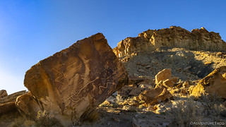
Located high above Muddy Creek, the Rochester Panel required a bit more of a hike than Mussentuchit Wash, but we'd sat enough in the previous 24 hours that being propelled by our feet was a welcome change. As we headed along the well-beaten trail, we didn't know exactly what to expect, but we did know it was apparently quite nice.
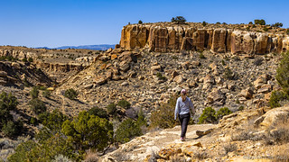

I think it's safe to say that we were both in awe when we arrived at the panel - or really, the set of panels - that sit on a point overlooking the confluence of Muddy Creek and Rochester Wash. The panel was enormous, and contained several very interesting figures, as well as the first of several rainbows we'd see on this trip.

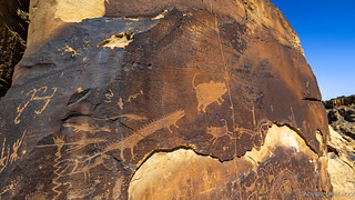


Realizing that there would be no shortage of petroglyphs on this trip, I think we spent less time here than we had at the first panel we visited, and soon we were on our way back to the Tacoma to decide our next steps.


Headed north towards the town of Ferron - where we planned to fuel up for the last time and air down for the first - both of us were getting a bit hungry, so we decided that our next stop ought to be the one where we would eat lunch. Looking back now, that meant we should have visited the Molen Seep Wash first - both because it was shorter and because it would have made for a more efficient route - but I was very much looking forward to seeing the Segregation Panel at Ferron Box, so that's where we went.

The route to Ferron Box follows a figure-eight pattern, and there are a few other rock art sites along the way that are interesting, so we paused our lunch plans for a few minutes while we checked those out.


The next panels we visited were interesting because - unlike the vast majority of rock art that is done on the vertical faces of patinaed stone - this work was done over a vast area of horizontal slickrock. While I'm sure it's not completely out of the ordinary, I've only seen this a few times before - most notably at Sky Rock Petroglyphs and along the Anasazi Trail.


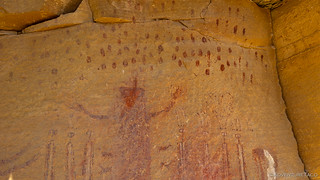
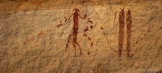
After gingerly exploring the area for a few minutes, we popped back into the truck and shortly reached the apex of our loop - the parking area for Ferron Box. I suggested checking out the pictographs before settling down for our sandwiches, and soon we were picking our way down into a deep channel cut into the Mancos Shale by Ferron Creek.

This area appears to have supported a significant population of Native American Indians in the past, but the unusual style of the rock art makes it difficult to determine what culture the inhabitants belonged to. While most of the petroglyphs and pictographs in the San Rafael Swell were made by the Fremont and Archaic Peoples who came before them, the art at Ferron Box is of a style not found anywhere else in the Swell.


Beyond the swallow nests, we came upon our second - though not our last - rainbow panel in as many stops. This panel is of special interest because the style of the art is so unusual. Its location certainly suggests that the artist must have been a member of the Fremont culture, but the imagery is unlike anything found elsewhere in the area. It has been suggested that the artist may have been an immigrant who came to the San Rafael Swell from another place. Perhaps this visitor is the unique figure in the Segregation Panel? I'd like to think so!

Our exploration of Ferron Box complete, we both settled in for a refreshing lunch - tuna, chips, and an apple - as we overlooked meander of the creek that we'd just enjoyed. Our talk as we ate was of the next spot on our journey, and what all we had planned for the remainder of the day.
Because if one thing was certain, it was that I'd planned too much. Especially for the first day after a long drive south, when we were both ready for a good night's sleep. Regardless, we set that aside as we put everything away and got back on the trail toward Molen Seep Wash.


Of all the panels we'd seen so far, I was excited to see the pictographs at Molen Seep as they were the first of the Archaic Panels that we'd see as part of this trip. Two things were interesting about the Archaic art was that it was largely done with pigment rather than etching, and it almost always depicts very detailed humanoid forms, rather than the sheep, animals, and abstract shapes that are more common in later rock art.


Retracing our steps, we were soon back at the Tacoma and on our way towards Short Canyon. Having more good sense than I had to look at the map on our GPS, @mrs.turbodb had found what appeared to be a road that connected our current location to a "back way" into Short Canyon that would keep us from hitting pavement again, so we gave it a shot.

Having been stymied in our first attempt, a bit more panning around suggested an alternate route that didn't dive headlong over the side of the canyon, and we headed that direction with much greater success - though there were a couple of gates that we had to let ourselves through along the way.


By the time we reached the entrance to Short Canyon - having come from the north rather than the more common southern route - it was clear that our shortcut had been anything but. While the terrain out here looked flat and the roads seemed to be in good condition from a distance, the reality was that numerous little washes had wreaked havoc on them, making the going slow as we were constantly easing ourselves over the 6- to 10-inch trenches across the road. Still, even if it was a bit frustrating, we couldn't complain about the surroundings.

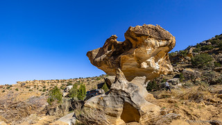
There are no petroglyphs or pictographs - as far as I know - at the mouth of Short Canyon, but this place is definitely worth a get-out-and-explore for another reason entirely. As you gaze up toward the towering walls of eroding sandstone and shale, you'll start to notice that there are spheres embedded everywhere!

According to scientists, the Mancos Shale was once a deep layer of sediment that was submerged under an inland sea. The Ferron Sandstone Member of the sediment consisted of sand, clay, carbonates and other minerals in just the right proportions so that when something like a leaf or a shell became buried in the mix, the minerals tended to precipitate out and coalescence in successive layers around the object. The process continued over a long period of time in before the sea eventually disappeared and the land hardened into stone. Now some parts of the Ferron Sandstone formation are littered with these spherical concretions. (Hidden Treasures of Utah's San Rafael Swell)
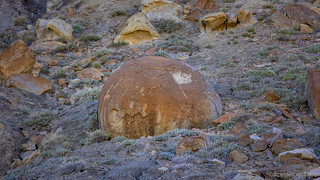

I probably spent 15 minutes scampering around under these gigantic bowling balls before heading back down the hillside to continue into the canyon - this was another place that Tim had suggested to me, and I was really looking forward to what we'd find inside!
Bumping along, the first panel we spotted was high on the wall of the canyon, and one of the most vibrant we'd see all trip.


A little over a mile into the canyon, we reached the end of the road. Already to this point it'd mostly been an ATV trail, but the Tacoma - being of the narrow 1st gen variety - had made short work of the rough terrain with only a few more pin stripes to show for it. We dismounted and set off on foot.
It was 5:30pm as we hiked up the wash. So far we'd accomplished less than 50% of what I'd planned for the day, and the Swell had been nothing like I'd imagined from a terrain perspective, but the good news was that we were both enjoying ourselves as we searched out the panels that we knew were scattered amongst the walls here in Short Canyon. Each time one of us would discover one, the other would be summoned for a look-see.


Forty-five minutes later - as the shadows were getting longer - we pulled ourselves back toward the truck, not sure exactly what our next move was going to be. With just under two hours until sunset, it was abundantly clear that we couldn't finish everything on our itinerary, much less reach the spot I'd hoped to camp for the night - and so was we walked, the topic of conversation turned toward modification of the original plan.


Ultimately, we decided that we'd continue on to a couple more sites, as there was one - the Ascending Sheep Panel - that I was extremely interested in checking out. Additionally, the fact that it was located on the top of Molen Reef got my hopes up that we might be able to find a nice overlook where we could camp for the evening. So, now in a bit of a rush, and probably not in the best of moods given our lack of sleep, pushed on.
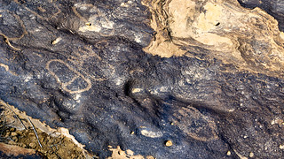
Our first stop was along the way to the next. Right alongside the paved Moore Cutoff Road, we spent just long enough at the Molen Reef panels to snap a couple photos and make the short trek to the (not very distinct and not worth photographing) dinosaur tracks.

With the wind picking up - not good for my plan to camp at the top of the reef - and with @mrs.turbodb a little worried that we'd be driving down in the dark, we headed to what would be our last location for the day - the top of the Molen Reef.
After finding what I hoped would be a nice camp site - partly sheltered by some juniper trees - we set off in search of the Ascending Sheep. Luckily for us, an easy-to-follow trail meant that the search didn't take too long, and the sun was still shining brightly as we rounded the last bend to discover one of the smallest panels I've ever seen!

Delighted that we'd found the panel so easily, and to have seen the level of detail in the centuries old art, the conversation as we headed back toward camp was of our favorite discoveries of the day. Mine was a difficult tie between the Segregation Panel and Ascending Sheep, @mrs.turbodb being partial to the Rainbow Star Trek Panel in Ferron Box.
As we set up camp and got dinner going, the wind that'd been picking up through the day seemed to dissipate as the sun dropped below the horizon, leaving us with a pleasant evening and a fabulous view.


It'd been a full day - of unexpected terrain, and amazing rock art. Not knowing if our delayed schedule would cause any issues on the rest of the trip, all we could do was to have faith that everything would work out. After all, when everything goes to plan, it's not an adventure!


Really interesting article.. I’ve been going to the “Swell” since 1978 but did not even know about the rock art in that area because I’ve always spent time at the “Wedge” or on the south side of Hwy 70 near Temple Mtn.
I’m heading out there in two days and I’ll check out some of the places you mention.
Thanks
Very interesting rock formations and an amazing amount of rock art. I have never seen this much in any location.
Great photos as usual.
Another sunny trip!!!
Thank you!
You are always welcome David; glad to hear that you're enjoying the reports!
(and sorry for the slow reply, I just found a bunch of comments that were incorrectly marked as spam, so I'll need to dig into the guts of the site to figure out what's going on)
Loved this route you took. great rock formations, my fav thing, and petr0glyphs (sp). I am behind on your trips, but saved so I can get to them all. Really enjoying the trips and locations. My grands, just like their Nana,me, are all nature lovers and rock hounds as well. They are out there camping out and sending me photos on my new Aura digital frame, they bought for my b-day. We are hooked up online and on-phone and they send me photos everywhere they go so I can enjoy their adventures as well and it's almost as good as going with them. I love it and have told them to ck out your site for ideas where to go. Thanks for great photos and stories we can share betw us all.
Glad to hear you're enjoying the stories - as always - Jeannie. And, it's very cool to hear that the grandkids are getting into the outdoors early - that's the best way, and something I've tried to do with the kiddo on this end as well. It's sometimes a battle to get her to go ("I don't want to go camping") but she always enjoys it so much once she's there ("This was the best day of my life!"). And a new digital frame - that's gotta be pretty cool! Anyway, I hope you enjoy the rest of this (and future) trip(s) - hearing when folks do is what keeps me spending the time to write them.