
I have to admit that we were a bit nervous as we climbed into the tent on our little hill next to Sid and Charley. As I'd pulled onto the pedestal, we'd noticed dozens of little burrows, and were a little concerned that we'd wake up to mice in the engine bay munching on wires.
Luckily, as I climbed down the ladder to greet the sun, no such fate had befallen us!


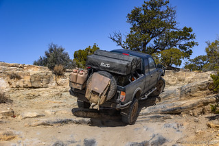
I knew we had a full day ahead of us, so my whistle to the one snuggled away in bed came earlier than usual, her relief that no rattlesnakes had slithered out of the burrows, apparent as she set about her morning routine. To make everything easier, I pulled down off the hill for tent stowage and breakfast preparation, both of which were done in a quick and efficient fashion that suggested experience. And then, we were on our way.


Heading east, we had approximately 15 miles of pavement - first on Moore Cutoff Road, then on I-70 - to our next destination at the Head of Sinbad. As we joined I-70 east, we began to climb. I suppose, looking back on it now, that we were climbing the western side of the San Rafael Swell, so technically the "unexpected" landscape we'd experienced the last two days simply meant that we hadn't yet really arrived.
As ground began to level out, an overlook presented itself, and while we don't generally stop at roadside viewpoints, for some reason I took the exit. Moments later, we found ourselves perched high on a limestone layer of the Carmel formation - prevalent across the Colorado Plateau - which formed in an ancient inland sea. As the sea covered giant sand dunes, they eventually turned to massive deposits of Navajo Sandstone. Here in the San Rafael Swell, erosion has cut the Navajo Sandstone into great white monoliths, knobs, and canyons, with the rock layers dipping slightly to the west. With erosion cutting and sculpting the rock over millions of years, the monoliths will become knobs, the knobs will become mounds, and the mounds will eventually succumb to erosion and disappear. Even the cliff from which this photo was taken will be worn away, and we may once again be standing at the bottom of the ocean.

After enjoying the view for a few moments, a little voice in the back of our heads suggested that we should get a move on - we had a lot of ground to cover - and we hopped back into the Tacoma for the final few miles to the center of the Swell and the Head of Sinbad.
Inexplicably, no exit existed, so we took the first one that presented itself - Temple Mountain Road - and backtracked on dirt until we came to a relative rarity, a tunnel under the freeway!


Before setting off on our trails for the day - what I hoped would be a nice break from the onslaught of petroglyphs and pictographs we'd enjoyed for the first couple days of our trip - we had a couple things to check out.
Pictographs, obviously! 

We spent longer at this first panel than we'd planned, as there was a Barrier Canyon Style (BCS) shaman that we were hoping to find - but couldn't. After a good twenty minutes, we finally decided to cut our losses and head to the next location, where we promptly found what we'd been looking for a half mile away!

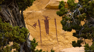

or The Snake Who Tells Time.

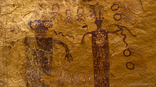
After visiting Falling Man in Gold Butte National Monument, I've enjoyed trying to capture rock art with a bit more context rather than as a perfectly straight shot. To me, it seems to add a bit more visual interest, since rock art is so often found on rocks that are themselves spectacular.

And with that, we wrapped up the pictographs. Mostly. Sort of. Well, for a few hours anyway.
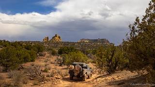
Headed north, we were now on a four-trail loop through the heart of the San Rafael Swell. The plan - if we could do it - was to follow Devil's Racetrack to Coal Wash to Fixit Pass and finally to Neilsen Dugway, ending up where we started. I say "if we could do it," because prior to departure, I'd learned that Fixit Pass had been unfixed by storms a few months earlier, and a couple of the videos I'd seen were somewhat hairy looking. Enquiries on various forums and groups hadn't yielded much in the way of information, so I knew that we could find ourselves backtracking if the road was impassable.
I had no idea at the time, but Fixit Pass would be a walk in the park compared to Devil's Racetrack. But now I'm getting ahead of myself. First, we had an arch to check out.


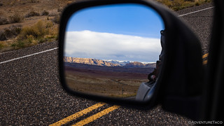
With Dutchman Arch in the rear-view mirror - or more appropriately, side view, since the rear is blocked and useless due to the tent - we took note of the "most difficult" sign at the beginning of Devil's Racetrack and cockily commented to each other that the sign was meant to warn off the Subaru Forrester's. And yes, looking back now, I feel as though a phrase about counting chickens might be appropriate.
At any rate, the first part of the trail was certainly more technical than anything we'd driven so far, but it wasn't all that challenging as far as I was concerned.


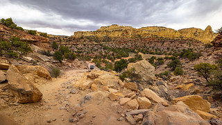
As we made our way further and further into the Head of Sinbad, the trail got trickier and more technical. Still, at this point it wasn't anything I was worried about as the increase in difficulty was a bit like sitting in a pot of water being brought to a boil - you don't really notice until it is too late.
Plus, as the difficulty increased, so did the beauty of our surroundings, and we were both really enjoying the change in scenery.


It was just before we reached the Devil's Backbone that things started to get a little hairy. And by a little, I think @mrs.turbodb would say, more than enough. Certainly, there were several places that required skill and a good line in order to avoid prolific use of skid plates and sliders. And, as the trail worked its way out onto the very edge of the canyon wall, there was one spot that created one of the most off-camber situations I think I've ever experienced.

With plenty of traction on the slickrock, the Tacoma performed well, doing nearly everything I asked of it the first time, and only requiring me to have a get-out-and-look-see in a couple of places - just to make sure I understood my tire placement before attempting a particularly tricky section. Still, the trail was definitely living up to its rating, and I nonchalantly asked @mrs.turbodb what we would have done if we'd happened on a trail like this back when we undertook our first adventure on the Oregon Backcountry Discovery Route (OBDR).
No question about it, we'd have considered it impassable.
To her credit, @mrs.turbodb rattled off a few of the most useful modifications to the Tacoma in the last several years - larger tires and experience being the most important - that made this only considerably terrifying for her.


Having successfully completed Devil's Backbone, I think it's safe to say that we were both hoping that the worst was behind us. For me, this was really a function of being a single vehicle - though as the day would progress, we'd see several other people on the trail. But rather than get easier, we shortly found ourselves at a set of ledges that stepped up a rise about 2- to 3-feet at a time, spaced approximately as far apart as the wheelbase of a 1st gen Tacoma. A bypass looked a bit easier - until it reached a vertical 4-foot ledge with sand at the top and bottom - making it a non-starter in my opinion.


We didn't know for sure at the time, but we definitely hoped that the worst was behind us at this point. It was only 11:30am, but the constant adrenaline over the last couple hours had both of us hungry, and we decided it was time to find somewhere with a view - and ideally some shade - to enjoy a tuna sandwich.


Having already spent three hours on the first of four trails for the day, we ate lunch relatively quickly so we could get back underway. Thankfully, the segment of the trail after lunch turned out to be less technical, so we made good time - except that someone kept stopping for photos - as we ticked off the miles towards Coal Wash.


Eventually we found ourselves descending off of the ridges that we'd been following and down into the washes that wound their way below.


Having completed Devil's Racetrack without incident, I'd say we were both relieved, though there was still a voice in the back of my head, nagging about the conditions on Fixit Pass. My only real concern at this point was that we might have to retrace our steps, if for some reason we couldn't make it out the planned route. For now though, we enjoyed the smooth surface of the sandy wash, the skinny pedal seeing more use than it had all morning.

We arrived at Slipper (Swayze's) Arch about 30 seconds after a group of UTVs approached from the other direction. Knowing there wasn't anything but Fixit Pass ahead of us, they confirmed that they'd come that way. Happy for some intel, I asked how they'd compare it to Devil's Racetrack. "About the same," was the response, which actually made me feel better, since the racetrack had been technical but hadn't really given us any trouble.


As we turned out of Coal Wash, the unfixed part of Fixit Pass presents itself immediately. Steep and a little rocky, my relief upon seeing it was palpable. This was most certainly not going to be an issue, and I actually felt a bit sorry for the UTV folks if they though Devil's Racetrack would be more of the same.

Cresting the pass, the scenery changed again. Here, the trail jogged north, pointing us once again toward the storm that was passing overhead, the clouds adding a nice bit of drama to the much redder landscape in which we were now immersed.


Now about 50% of the way through our four-trail loop - and with it nearing 2:30pm - we pressed on. I was pretty sure that the rest of the route would be much quicker, but I didn't want to take any chances, and I still had a few more things on the day's itinerary - hopefully - when we were done.


Less than half an hour later we wrapped up our time on Fixit Pass, and transitioned to the Nielsen Dugway. It wasn't much of a transition - except for the name - as the trail difficulty and surroundings stayed pretty much the same. After a quick chat with the occupants of a couple UTVs - one of them cracked a rim somewhere on the trail, and they'd both neglected to bring a spare - to ensure that they had someone coming with a replacement, we tackled the last several miles to great delight.
Even with the fantastic lighting, the highlight of the Nielsen Dugway was thanks entirely to my copilot, who - in some way I still can't figure out - spotted a trio of bighorn sheep more than half a mile away. To our delight, the road would take us directly under their position, and I hoped that our lower standing would give them confidence to refrain from running off.


In no time, we neared the final ascent of the dugway back to our starting point at the Head of Sinbad and I-70. Yet again the ground under tire changed colors, and appeared to do so several more times before we were done!


Where the first quarter of the loop had taken us the better part of both the morning and early afternoon, the remaining three quarters of our route had flown by, leaving us plenty of time to head south - way south - to find camp near Temple Mountain. After, of course, we hunted for a few more pictographs.
Because you can never have too much rock art. Mostly. Sort of. 
The loop I described here is a fantastic one that I feel showcased some of the best scenery that the San Rafael Swell has to offer. That said, I highly recommend running it - or at least running Devil's Racetrack - with two or more vehicles due to the difficulty of the terrain. Single vehicles can run the loop in the opposite direction, from Nielsen Dugway to Fixit Pass to Coal Wash, and then either return the way they came or continue north in Coal Wash to Ferron.


The narrative and the pictures are addictive. Thanks.
I can’t imagine handling the adrenaline rush climbing that staircase.
Thanks Joe, glad you enjoyed the pics and story! It was definitely something that had me shaking a bit when I got to the top... and wondering if there was more to come! A bit of type 1 and a bit of type 2 fun, for sure! ? ?
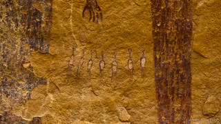
We visited the Swell in early October, and visited the Head of Sinbad pictographs. Coincidentally, the day before, we saw a herd of bighorn sheep near camp. In the evening light, their white butts glowed! After seeing the “chickens” between the pictograph figures, we all decided they were,big horn sheep, not chickens! Amazing coincidence.
OMG, you're right! That's fantastic, thank you so much for sharing that realization! Amazing how the right light/perspective in real life can open our eyes to seeing the ancient rock art in an entirely different way.
Have you spent much time in the Swell? Any favorite places (that you're willing to share)?
No, it was our first time! Our friends’ second time. We actually were very inspired by your trip! We did spend 3 nights camped in Crack Canyon before the trail starts. It’s the road off Behind the Reef road, before you get to the official trailhead. Honestly, we stumbled on it! We based ourselves there for three nights and hiked Wildhorse, Crack and Chute. Chute was my favorite!