
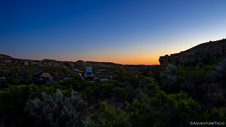
With canyon walls around us, and clouds in the sky, I didn't even set my alarm when we went to bed - so sure was I that sunrise would be a non-event. But, as often happens, my internal alarm woke me at just the right time. A quick peek out the tent door, and it was apparent that somewhere - just out of sight - was orange.
Though it was chilly, I climbed out of bed and realized that I might actually have a shot if I climbed to the top of the canyon wall. Time wasn't on my side though, so it was more of a sprint up the wall for the last few minutes of light along the horizon.


More awake than usual with my early exercise, I decided it best not to climb back into bed, but instead to hang out an read for a few hours until everyone else was up and about. Around 7:00am Will @willhaman21 got himself up and out of camp - he had to work, despite it being Saturday of Memorial Day weeked - and an hour or so later, the rest of camp began to stir.
All of our normal tasks and routines were wrapped up by 9:00am and we were on our way out of the wash; north towards Silver City!

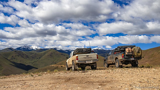
Where The Silver City road from the west is a highly travelled two-track, it's clear that most visitors come from the east. Here, the road was paved a good bit of the way, making for easy travel and great views of the snow-capped Owyhee Mountains.

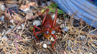
Along the way we also ran into a swarm of Mormon Crickets - actually, one swarm of many that we'd seen the last several days - their size and numbers always both a bit surprising and a little creepy.
Eventually the pavement ended, but even so, this road was quite obviously better maintained than the one we'd attempted the previous day - the grading obvious, and as we'd soon discover, it was even plowed at higher elevations!


As we crested the high point of the journey at New York Summit, we paused again - the green, white, and blue unfolding picturesquely before us. Making it here meant that we'd finally be successful in reaching Silver City - for us, the third time was a charm!

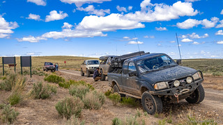
Not that we really had any doubts - the road in had been a super highway of vehicles - UTVs mostly, but also a few Jeeps and even a couple passenger vehicles - Silver City was bound to be a hopping metropolis on this first day of Memorial Day weekend.


Our first stop in town was at the historic cemetery. As we solemnly explored the graves - many of which included the original headstone as well as a more recent memorial plaque, it was striking to see how young many of those laid to rest really were a stark reminder of how tough life was in the 1800's.


From there, we entered the town - first for an auto-tour, to find parking; then for a walking tour before lunch.

Silver City began in 1863 when Michael Jordan and a part of prospectors from the Boise Basin headed for the Owyhees. They struck pay dirt on Jordan Creek. When word of the new diggings leaked out, some 2,500 men poured out of Boise overnight and tramped the sage brush trail to Owyhee... The new town stretched out along Jordan Creek and up the mountainside, thriving on rich veins of ore deep within the earth... The most prominent mines became famous, their romantic names - the Ida Elmore, Golden Chariot, Morning Star - rolled off tongues all the way from San Francisco to London.
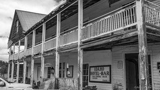
Today, it is a ghost town of its former self, yet not entirely a relic of the past. People summer here and continue to patch up the old place, so it teeters on the brink of coming alive again... It's a far cry from the old days... The old schoolhouse has become a museum housing Silver City relics, and the picturesque little Catholic church (originally Episcopalian) holds services occasionally. The sagging Idaho Hotel still stands, a faded dowager now. Roadside History of Idaho


It was 1:30pm as we wrapped up lunch and fired up the Tacomas to caravan out of town. Silver City was a cool place, but as we headed back into the mountains, I think we all found ourselves wishing we'd visited it on a less-busy day.

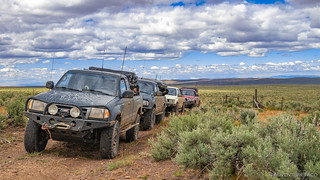
Half an hour later, we found ourselves in that transition zone between mountain and high desert, the views to the east too tempting for Mike to pass up. Not that I had any problem with that - never one to skip a nice overlook.

From the Silver City Road, we scooted ourselves down Highway 78 to Grand View for fuel, then south on Highway 51 towards our next - and final - two destinations for the day: Wikahoney and Indian Hot Springs.
Unsure of the road conditions to Wickahoney, but knowing that the road to Indian Hot Springs would benefit from lower tire pressures, I suggested that we air down as soon as we hit dirt just for a bit more comfort. There were no complaints - naturally - and expecting to have the road - which was litterally in the middle of nowhere - to ourselves, we just shut off the trucks and started airing down.
So, you can imagine our surprise when a Nissan Pathfinder approached from the opposite direction. Go figure!
The only traffic we'd see the rest of the day now in our rear view mirrors, we completed our squishy-tire-mod, and headed out along roads used only infrequently, and happy for the extra cushion we now had to absorb the bumps.
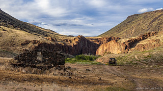
As we arrived at Wickahoney - a place that both Ben @m3bassman and I had wanted to visit since we'd seen it on satellite imagery - we were all surprised at what we found. On satellite, the location looks like a short foundation, but of course, with an overhead view, there's no way to determine height. In fact, the walls of this old stage stop were still largely intact, doors and windows breaking up the stonework.

We poked around the main building and several other rock structures for 20 minutes or so, the moo-ing of nearby cows a soundtrack to our exploration.
Wickahoney is an abandoned post office and stagecoach station between Mountain Home, Idaho and Mountain City, Nevada, which served the community from 1895 to 1911. Built with lava rock, it originally featured a wooden porch and a shingled roof with seven gables. The route brought supplies to mines in northern Nevada and was considered to be Wickahoney's best chance at economic success. However, a stagecoach route through Elko, Nevada supplanted the route through Wickahoney, and the community eventually faded away.wikipedia

By now, it was getting on in the afternoon. A little after 4:00pm, it was time to get going - the route to Indian Hot Springs - our final destination on the other side of ID-51 - some two hours away... assuming the route was passable.
We headed south.


As we neared the point at which we'd cross ID-51, we spotted a compound in the distance. None of us sure what it was, we all took guesses. A correctional facility? A military installation? A pig farm?
With no signage, we never found out.
Update, Sep. 2020 (@Idaho_Pakeha): "This is a a military target. If you had looked at it up close you would have noticed that it has no actual foundations, just posts on cinder blocks. There are some other strange features too, like the 'smokestacks' that are made of sheet metal. it is actually a simulated 'Iraqi Chemical Weapons Plant,' or so i was told when we visited the site back in the day, prior to construction."

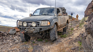
Across the highway and onto Rowland Route Road, we made good time over the first dozen or so miles towards Indian Hot Springs. This all changed though as we turned off the main drag. From that point until we reached our destination, the going was slow - the road alternating between being covered in softball-size rocks and standing water (and mud) from the rain earlier in the week.

It was a slog, one that several of us commented on over the CB radio - but not one that any of us who'd been here before had remembered as a standout feature of this road. Perhaps that's because when Ben and Kirsten had been here, they'd been stopped on the final descent - at 11:30pm - by a pair of fallen boulders, forcing them to back up the shelf road in the dark. Perhaps it was because when @mrs.turbodb and I had been here, we'd made it down the shelf road only to discover that the bridge across the Bruneau River at the bottom of the canyon was too dilapidated to cross - and since we wanted to explore the eastern route to the springs as well, that meant retracing our steps and making a 100-mile detour around to the other side.
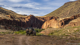
Whatever the reason, we were glad when this section of road was behind us and we found ourselves at the upper entrance to the shelf road and the Bruneau Cherrystem sign.

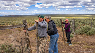
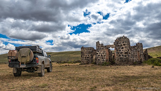
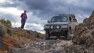
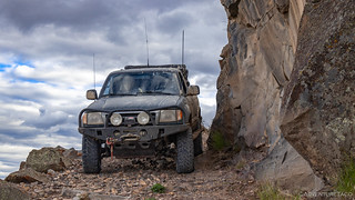
Unsure if the shelf road would be passable - or whether the section that had begun to wash out a year ago would be even more-so after another winter - we got out of our trucks to survey the situation, and investigate the ruins of a stone cabin that's perched here, high on the canyon wall.


To our relief, the road seemed in essentially the same condition it'd been in when we visited the previous year, so we decided that @mrs.turbodb and I would drive down, radioing back when we reached the bottom - just in case a rockfall further down required us to back all the way out.
It was slow going - but fun - and within 10 minutes or so, we radioed back that the next truck should make its way down.
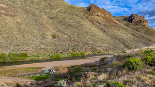
We'd made it to Indian Hot Springs, and our timing couldn't have been better. At a little after 7:00pm, the evening sun was streaming in under the clouds, but was still high enough to light the bottom of the canyon. The views here are spectacular, worth the trip even if you aren't one to partake in the soaking experience.

While we waited for the rest of the crew, we explored the ruins of the old rock buildings down here in the valley. Whoever had made a home here so many decades ago had been lucky to find such a spot, even if the route in - and out - must have been exceedingly difficult.
We also explored the new bridge over the Bruneau River. This bridge was the reason that I'd wanted to come back to this place. Not only had it been an impassable obstacle on our previous journey, but I'd received an email after *someone* read our Double Dose of Indian Hot Springs story (full trip) telling me that the bridge had been replaced. Initially I'd been skeptical - the old bridge had been in place for so long, and the location was so remote - who in their right mind would replace it? But, sure enough it turns out that the company leasing the land (Simplot), with permission from the BLM, had decided it was worth it in order to more easily retrieve cows who wandered across the natural boundary.


Soon enough, Ben and Mike @Digiratus showed up, followed shortly by Zane @Speedytech7. It was time to find camp.

Naturally, we wanted to camp down by the hot springs. Ben made his way down first - though the 180° water onto a rocky bar - where he discovered two mountain bikers had claimed the prime location, likely not more than 30 minutes before our arrival.
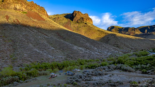
Luckily however, a little further on - though with no access to the springs - we found a nice private site with plenty of room and a fire ring where we could setup camp.
Normally, this might be the part of the story where things start to wind down - we'd get set up, make dinner, enjoy our last camp fire as an entire group - that type of thing. But not this evening. In figuring out the perfect spot to position his truck, Ben discovered that it wouldn't start.
On the one hand - he was lucky to have made it to camp with no real trouble. On the other - what, the truck won't start?!
First, he used his LiIon jump pack to get himself up and running again, but as we all do, he accidentally turned off the ignition before he could fully recharge his jump pack. Pretty sure the issue was a dead battery, and 100% sure that the battery posts and clamps were thoroughly corroded, he set about removing and cleaning them as Mike and I measured the voltage across the battery.

The battery voltage seemed OK, but turning the key still resulted in only a single click and the hum of the fuel pump. I pulled my truck into position to try and get him started and we hooked up my battery to his. Nothing. Then, we took his battery completely out of the loop and hooked his positive and negative clamps directly to my battery. Uh oh.
At this point the leading cause became the starter. Zane grabbed a hammer and gave a few good whacks to the starter housing to try and unfreeze it. Nothing. Ultimately, Ben decided that he'd just leave it for the evening, and get a bump-start in the morning.
From Mike, because Zane, @mrs.turbodb, and I were headed out early - all of us needing to be back home on Sunday rather than returning on Memorial Day itself.
So, we all gathered around the fire, made our dinner, and chatted late into the night. It was after all, our last "all there" camp fire of the trip, and so no rush for it to end.
- - - - -
Half of us were up bright and early the next morning. While Ben and Mike planned to head out over the newly constructed bridge and out the easier access road to the east, the two trucks leaving early were headed back out the way we'd come - up the shelf road to the west, and out through the bumps and mud to ID-51.
By 7:15am, we'd completed the climb to the top of the canyon - uphill for me, always an easier proposition.

The road out seemed less bad than the it had on our way in. Muddy, it still was, but the bumpiness and rocks that had worn on us all seemed about half as bad as we made our way north west. Perhaps it was the difference between driving a road like this at the end of the day vs. the beginning.
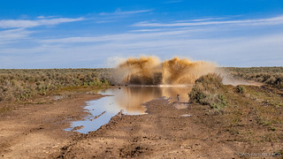
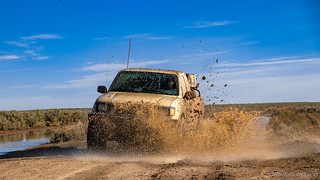
Mostly uneventful, there were a couple of flooded sections where I couldn't resist a few shots of the white truck helping itself to a free "wash" and then subsequent re-mudding.


And then, just as we were sure that the excitement was done, an ATV approached. We passed - courteously as always - only to see the rider waving his arms in our mirrors. I stopped and got out, wondering if this was perhaps the landowner, wondering what we were up to.

But it wasn't - not by a long shot. I didn't know yet, but it was *someone* named John, who greeted me with, "You're AdventureTaco!" Having been recognized a couple times in the past, I smiled and admitted to the name calling, at which point John added, "I'm the guy who emailed you about the bridge!"
Holy smokes - what a small world! This is one of the parts of exploring that I find extra special - when two people meet "in the out-there's," happy to be doing their own thing and yet even happier when meeting a kindred spirit and reveling in the coincidence of it all!
We chatted for a few minutes about the condition of the trail, and I assured him that it'd be no problem making it down to the hot springs on his ATV, and that he should say hi to the couple trucks we left down there. Then, we were each on our way - the Tacomas headed home and John just starting his adventure towards the springs!
Thanks for reading, get out there an explore!
The Whole Story


Love Owyhee? Check out
more Owyhee trips
for all the amazing places I've been in and around this special place over the years.
As always, really great pics and write-up. Truly a small world! I talked to the bicyclists,....they were hurting on their touring non suspensions bikes. That road not made for skinny bike tires. John
Great to see the bridge was fixed. This has been on my list of places to visit!!!
I'm not sure the bridge helps all that much really Keith - I mean, the east route in is really the better route for most folks and the bridge isn't needed for that. But, very cool to see the bridge, for sure!
Another good write up and great photos. I've enjoyed all of your articles about this area and it is definitely going on my list of places to explore.
FTI, I did notice some typos in the text just below the Cherrystem sign photo.
Thanks Keith! I'll take a look for those typos too 🙂 ?.
It looks like you got the canon to canyon one, but missed the our to out one? Sorry if I seem to be picking on these, I'm truly not. I just personally hate when I find typos in my own blog posts after I have published them!
The tan building at the end of Duncan Butte road is a simulated bombing facility the Air Force uses for the famous A-10 "Skullbangers" use to laser bomb. There are three of these facilities the biggest one to the east from Wickahoney.
Several times I have seen the A-10's flying low to their target and giving me an airshow for about an hour. When you hear a loud roar this is the A-15's flying high and fast often breaking the sound barrier. This is part of the Saylor Creek bombing range.
There are also dozens of old homesteads in the area just waiting to be explored. I have traveled this area extensively on an ATV/UTV. The new Indian Hot Springs bridge is a welcome sight as the old one was very scary to cross. This is one of three places you can cross the Bruneau River. Simplot use this area to winter his cows.
Great trip and great photos, thanks for sharing.
Thanks Kenny - that info about the Duncan Butte road complex is great to know! Perhaps on a future adventure, we'll be lucky enough to see an A-10 come buzzing through - that would be exhilarating for sure!
Love the pics and wanna get down there soon to check it out. Just one complaint. One of your pics showed someone standing on the walls of the cabin that overlooks Indian Hot Springs (I think). You guys know better than that. If every person that goes there climbs/stands on those structures, it won’t take long before they are rubble piles. Sorry to throw rain on your obviously cool trip, but these things are only awesome because they haven’t been torn up (although I saw the graffiti on there too). Let’s leave them intact so our kids and grandkids might get a look at them.
Hey man, glad you enjoyed the trip! The cabin you see in that pic isn't the one down by Indian Hot Springs, it's one up on the plateau that's not really historical in any way. It was built in the 1970's (given the date etched into the concrete) with rock and mortar, likely as part of the ranch that's on that land. Not only that, but whoever is leasing the land now uses that ruin to store dead cow carcasses, as there were three of them in various states of decay, and bones from several more.
At any rate, we're pretty good about trying to respect historical artifacts, and in this case, there wasn't really anything historical about it. You'll note that we didn't walk on - or even in - the cabins down by the springs - those are much older, and utilized much less robust construction (dry stacking).
Lastly, and for completeness, I should note that I do think there are times where walking on/in old/historical structures is OK - for instance, exploring the interior of an old mill or cabin. Clearly one should be careful and respectful in these cases, but if it can be done safely and without materially affecting the structure, I think it's OK. ?
That Pathfinder (white 2001 )may have been me. I was in the area May 2020.
Haha! Nice! Such a small world. If it was you, glad you found the story.
Trying to get some road updates since I am heading down that way in two weeks. You said that there is a wash out? How sketch was it. I will have some full sized vehicles traveling with me. Think it would be a problem. I know your info is a couple years old at this time, but some info would be better than no info. Thanks! George.
Hey George, though I don’t have first-hand knowledge, I’ve heard that the washout has gotten worse in the last couple of years, and I felt like it was a squeeze in my 1st gen Tacoma, when we did it a couple years ago. At the time, I certainly would not have been comfortable driving a full-size truck Down that road, and I am reasonably comfortable on relatively sketchy roads.
Personally, I would recommend coming in from the east side, especially with full-size vehicles. The west side approach is really more for ATVs these days.
Ok, Thanks for the info! I will probably still scout it out, but was wondering what the odds were. Funny that you could drive that road, but could not cross the river when it was high. Now you can cross the river, but can't drive the road... Maybe they plan on some road repairs too? I will report back on our findings. Thanks again! George.
Please do report back! I was out that way not too long ago, but headed further north on the plateau rather than dropping down to the hot springs, so would love to hear what the road conditions are like.