
By some stroke of luck, our hope - that it wouldn't rain any more after we climbed into our tents - was realized and then some. A strong breeze blew all night, not only keeping the tents free of any dew, but also helping to dry out the roads - at least a smidge.

This morning in camp was a reunion of sorts. For all of us obviously, since it was our first real group trip of the year (though I'd seen Ben and Kirsten in Death Valley for a single day a few months earlier) - but mainly for Ben @m3bassman and Mike @Digiratus who hadn't been on a trip together since The De-Tour in 2017!
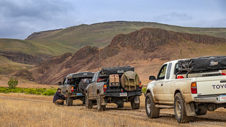
That, combined with late arrivals and a still-very-overcast sky, meant that it was 10:45am when we finally lined up the trucks to air down and roll out of camp.

Our first stop of the day wasn't far - a few miles at most up Camp Kettle Creek Road to Devil's Gate. Representative of the landscape in the Owyhee's, what look like rolling hills and vast plains are often broken up by deep rocky canyons. This one - while short relative to some - opens up at a big dry fall that makes a great place to escape from the hot sun in the middle of summer.
Of course, that wasn't an issue today as we slipped and slid our way up the muddy road to the parking area before wandering through Devil's Gate to explore the dry fall.


This is where we'd planned to camp the previous night, but in hindsight, it's a good thing we didn't. There wasn't a level bit of ground here, and in the light of day we discovered - though not before the two pups, Milo and Venice ran through it - that the base of the canyon was completely covered in poison ivy!
Time to move on, we all loaded back up into the trucks and pointed ourselves south - for what turned out to be a long muddy march towards Jordan Valley (which we wouldn't actually reach until the following day).

It was slow going as our tires strained for traction, the usually-dusty road having turned into a slop of clay, quickly clogging our lugs and flinging up in all directions, our steering wheels seemingly useless in several sections.


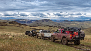
It was only a bit after noon when we found a nice hillcrest that was perfect for lunch - or as perfect as we were going to find, the sparse grass doing little to keep our shoes from picking up mud in the same way as our tires. In the distance, Three Fingers Rock - our next destination - was visible, the sun and clouds battling each other in the sky above.

Our bellies happy - and therefore, campers happier - we set out again, now with only a couple miles to go before what I knew was going to be an interesting section of road to Three Fingers, but I'm getting slightly ahead of myself. Despite all the mud, it really is striking how beautiful Owyhee is in the spring - all of the hills covered in green grass, new life everywhere.

Soon enough, we'd reached our turn up to Three Fingers. This was a road @mrs.turbodb and I had discovered on our very first trip to the Owyhee Canyonlands - but as infant explorers at the time and with no sort of map, we'd failed to follow it to its terminus! Live and learn, live and learn.
Over the CB, I mentioned to Ben that this could end up being a challenging road - steeper than it looks, and possibly impassable if it was as muddy as what we'd been on so far this trip. As such, we decided that one truck at a time would make the run, each calling back down once safely at the summit. And with that, Ben was off!

The climb turned out to be no problem at all - the road up the hill much rockier than those that we'd travelled over the plains - and before long, Mike - running tail gunner this morning - was on his way up.

Three Fingers was now within easy reach as we paused for a moment to take in the nearly 360° view of our surroundings.


Having climbed up a small rocky outcropping to get a little more perspective, I was looking down on the rest of the group as I saw Ben, Zane, and @mrs.turbodb scatter away from Mike's truck. "That's strange," I thought to myself, and headed down to see what the commotion was all about.
"There's a rattle snake over there," said pretty much everyone at the same time! 
Not one to ever pass up a reptile, I headed the opposite direction to the general flow of humans and eventually heard the little guy rattling away behind some brush and under a rock. Well, that wasn't going to do - there was no way to see him with all those branches in the way - so I carefully pulled back the sage brush and snapped a few shots.

A few more minutes in the trucks and we arrived at Three Fingers. From here, I'd hoped that we could find our way up - to the top of at least one of the fingers - and so we set out on the half-mile-or-so roundtrip around the north side, the views expanding with every step, a small arch visible from just the right position.


Not as obvious at first glance, we eventually found the scramble up to the top of the first finger and waved down to Mike who'd stayed at the trucks for this one. And we found one of the largest geocaches I've every come across - as though several visitors before us all had the same idea to bring up a container full of goodies!


It was time for a quick photo, and the interval timer on the camera did a fabulous job of capturing the moment.


Soon enough we retraced our steps back down to the trucks and continued our trek south - rejoining Succor Creek road, following it the remainder of the way to highway 95 - where we contemplated our next move.

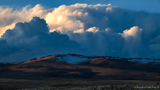
Our loose plan at this point had been to head southeast towards Silver City - a place we'd been unable to reach due to snow on our previous trip - but with all the rain in the last couple days, we could see that the Owyhee Mountains surrounding the town were quite snowy, so decided it would be better to keep to the lower elevations one more night.
With that, we made the call to head to Coffeepot Crater - at the north end of Jordan Craters - to explore the lava flow and its numerous tubes, channels, and of course the seven cinder cones themselves.


A 27 square mile olivine basalt lava flow, most of the Jordan Craters lava field is ~3000 years old. However, an 18-acre flow within the field is thought to be less than 100 years old because not even lichens have begun to colonize it. Coffeepot Crater itself was born when mildly explosive eruptions constructed a cone from overlapping lobes of dense and fragmented material thrown from the volcano. Rising magma then occupied the volcano’s center, creating a lava pond, and eventually leaked out along a 0.7-mile fissure extending southwest from the main crater, creating a moonscape that extended 10 miles from the crater.

As @mrs.turbodb and I had done at the southern end of the flow, we spent a good amount of time walking out and exploring this northern end. We'd not read the sign in the parking area before setting out, and I'd wondered if we could find a spot where there was little to no vegetation, if we got far enough into the field that the wind hadn't carried organic material in from the sides. We never did, but perhaps someday we'll find those 18 acres.


We, of course, also spent some time walking around the crater - a very cool experience in itself. This - at least in @mrs.turbodb and my opinions - is a much more interesting place to explore than even Craters of the Moon National Monument, if only because it's a much more natural environment, with many of the same features, and exactly zero other visitors.


By the time we were done, it was nearly 5:45pm and time to find camp. Luckily for us, Mike had camped nearby on his previous trip to the region, and so we headed that direction for the remainder of the evening.

Of course, though the skies had been clearing all day, it wasn't long after we arrived in camp that the rain started. It didn't last long, and soon the sun was streaming in under the clouds, a bright rainbow shooting down out of the sky to the hillsides above.

With plenty of daylight left, we circled our chairs and started the fire - stacking wet(ter) wood around the ring to dry it out prior to its conversion to charcoal. The conversation flowed easily, as though the three year gap in getting together as a group had been mere minutes. It was fantastic. And so were the burritos with guac that we had for dinner!

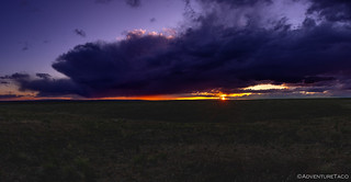
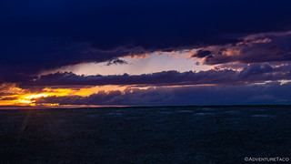
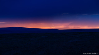
We were in a bit of a depression on the landscape, but a little after 8:00pm I noticed a glow in the western sky. I excused myself from the conversation and made my way to the nearest knoll to enjoy what I hoped would be a dramatic sunset.
At first, it was just long, warm light on the landscape around me...

But then, the magic. All the moisture in the atmosphere made for plenty of particles to reflect the light, and a purplish hue spread across the land. Rain showers in the distance glowing under the clouds.
Happy to have made the short trek away from camp, I wandered back, equally happy to spend more time around the camp fire with friends. We chatted into the night - retiring to Mike's and Ben's awnings to weather the first and second rain showers passing over camp.
Eventually we all bid each other good night and climbed into our tents. The next day was going to be interesting - we couldn't put off our attempt to reach Silver City any longer - and with the snow level seemingly lower than it been on our last trip, that was going to be an interesting endeavor...
The Whole Story


Love Owyhee? Check out
more Owyhee trips
for all the amazing places I've been in and around this special place over the years.
I love exploring the Owyhee area of Oregon.We are heading back that way here in a week or so. Nice work on the trip reports.
Thanks Nate! Glad you're enjoying the stories, they are a lot of fun to put together, and it's nice when others appreciate them. 👍